Showing 1361 items matching "land for sale"
-
 Ringwood and District Historical Society
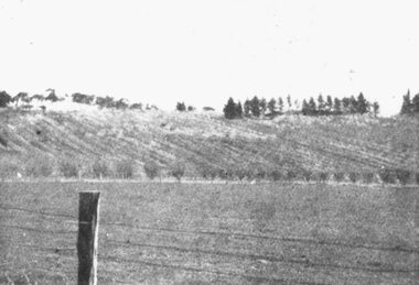
Photograph, Panoramic View of land for sale. Coleman's Heathmont Estate 15/12/1923
... Panoramic View of land for sale. Coleman's Heathmont Estate 15/12/1923...For additional details of the Coleman's Heathmont Estate land sale see VC5154....For additional details of the Coleman's Heathmont Estate land sale see VC5154. Black and white photograph Panoramic View of land for sale. ...Black and white photographFor additional details of the Coleman's Heathmont Estate land sale see VC5154. -
 Ringwood and District Historical Society
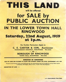
Poster, Land for Sale by Public Auction, Lower Town Hall, Ringwood - Saturday 22nd August, 1959
... Land for Sale by Public Auction, Lower Town Hall, Ringwood - Saturday 22nd August, 1959...Yellow poster and smaller attachment with auction details and summary of four properties offered under Borough of Ringwood instructions for unpaid rates, some with handwritten monetary notations. Land for Sale by Public Auction, Lower Town Hall, Ringwood - Saturday 22nd August, 1959 Poster ...Yellow poster and smaller attachment with auction details and summary of four properties offered under Borough of Ringwood instructions for unpaid rates, some with handwritten monetary notations.Lot 49 Patterson Street, East Ringwood (Opp. station). Made Road, Water and E.L. 60'x220' approx. Lot 48 Stoda Street, Heathmont. Water and E.L. 50'x150'. Lot 86 Cnr Heatherbrae & Burwood Avenues, Ringwood. Made roads, Water and E.L. 54'x140' approx. Lot 13 Tagell Road Ringwood. 64'x1130' approx. For further particulars apply to C.E. Carter & Son, Auctioneer, Maroondah Highway, Ringwood (Phone) WU6042, WU6830, or Borough of Ringwood, Town Hall, Ringwood (Phone) WU6616. F.P. Dwerryhouse, Town Clerk. -
 Ringwood and District Historical Society
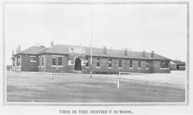
Photograph, Ringwood State School photograph for land sale - Charm-View Estate, Heathmont - 1926
... Ringwood State School photograph for land sale - Charm-View Estate, Heathmont - 1926....Written on back of photograph, "Photo taken from Sub. Div. Plan Land Sale Charm-View Estate, Heathmont. 1926?"...Written on back of photograph, "Photo taken from Sub. Div. Plan Land Sale Charm-View Estate, Heathmont. 1926?" ...Printed below picture, "This is the district school". Written on back of photograph, "Photo taken from Sub. Div. Plan Land Sale Charm-View Estate, Heathmont. 1926?" -
 Kew Historical Society Inc
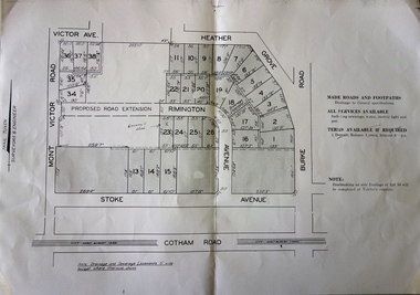
Plan, F R Simms & Son, Land for Private Sale: Cnr Victor Avenue and Mont Victor Road, Kew, 1950-1960
... Land for Private Sale: Cnr Victor Avenue and Mont Victor Road, Kew...Subdivision plan advertising five superb home sites among lots in Burke Road, Stoke Avenue, Victor Avenue, Mont Victor Road and Heather Grove. Land for Private Sale: Cnr Victor Avenue and Mont Victor Road, Kew Plan Plan F R Simms & Son ...George Rimington established The Parkhill Nursery in 1877. By 1910, it was more commonly known as Rimington’s Nurseries and well known for its sale of violets. After World War II, Rimington’s Nurseries were gradually subdivided and sold. The 38 allotments were released in sections, including lots 34 to 36 on the corner of Mont Victor Road and Victor Avenue. Previous lots in the subdivision had bordered Burke Road, Rimington Avenue, Heather Grove, and Stoke Avenue. The selling point as it had been in comparable estates for a century were the proximity to transport, schools and churches, as well as the high location and excellent views. The subdivision plan shows most of the lots in the entire subdivision: 1-11, 13-26, and 34-38. Presumably, lot 12 and lots 27-33 were still to be released.Subdivision plans are historically important documents used as evidence of the growth of suburbs in Australia. They frequently provide information about when the land was sold on which a built structure was subsequently constructed as well as evidence relating to surveyors and real estate and financial agents. The numerous subdivision plans in the Kew Historical Society's collection represent working documents, ranging from the initial sketches made in planning a subdivision to printed plans on which auctioneers or agents listed the prices for which individual lots were sold. In a number of cases, the reverse of a subdivision plan in the collection includes a photograph of a house that was also for sale by the agent. These photographs provide significant heritage information relating house design and decoration, fencing and household gardens.Subdivision plan advertising five superb home sites among lots in Burke Road, Stoke Avenue, Victor Avenue, Mont Victor Road and Heather Grove.subdivision plans - kew, rimington avenue -- kew (vic.), heather grove -- kew (vic), stoke avenue -- kew (vic.), burke road -- kew (vic.), mont victor road -- kew (vic.) -
 Bendigo Historical Society Inc.
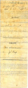
Document - LAND GRANT SALE DOCUMENTS FOR DR. JAMES BOYD, 1858
... LAND GRANT SALE DOCUMENTS FOR DR. JAMES BOYD...Land Grant Sale...Three Land Sale documents issued to Dr James Boyd for Grant by Purchase of three blocks of Land. a. 24 March 1858 Allotment 6 of Section 8C b. 18 March 1858 Allotment 14 of Section 8C c. 18 March 1858 Allotment 13 of Section 8C Blocks with near intersection of Mollison and Mundy Streets...Land Grant Sale James Boyd Three Land Sale documents issued to Dr James Boyd for Grant by Purchase of three blocks of Land. a. 24 March 1858 Allotment 6 of Section 8C b. 18 March 1858 Allotment 14 of Section 8C c. 18 March 1858 Allotment 13 of Section 8C Blocks with near intersection of Mollison and Mundy Streets Document LAND GRANT SALE DOCUMENTS FOR DR. ...Three Land Sale documents issued to Dr James Boyd for Grant by Purchase of three blocks of Land. a. 24 March 1858 Allotment 6 of Section 8C b. 18 March 1858 Allotment 14 of Section 8C c. 18 March 1858 Allotment 13 of Section 8C Blocks with near intersection of Mollison and Mundy Streetsland grant sale, james boyd -
 Tarnagulla History Archive
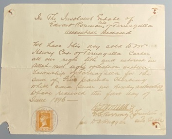
Receipt for Land Sale Estate of Edward Rosman to Henry Cox, 1896
... Receipt for Land Sale Estate of Edward Rosman to Henry Cox, 1896....Tarnagulla History Archive Tarnagulla Public Hall 69-71 Commercial Rd Tarnagulla goldfields Receipt for Land Sale Estate of Edward Rosman to Henry Cox, 1896. ... -
 Ringwood and District Historical Society
Photograph, Ringwood State School photograph for land sale - Bestpart Estate, Ringwood - 1925
... Ringwood State School photograph for land sale - Bestpart Estate, Ringwood - 1925....Ringwood State School photograph for land sale - Bestpart Estate, Ringwood - 1925. ...Written on back of photograph, "State School, Greenwood Avenue. Foundation stone re-erected in Greenwood Avenue. Transferred from old site Ringwood Street and Whitehorse Road". -
 Ringwood and District Historical Society
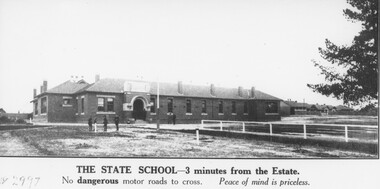
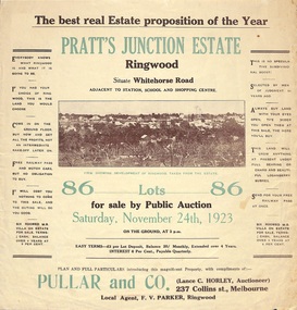
Flyer, Brochure for Land Sale By Public Auction, Pratt's Junction Estate, Ringwood, Victoria - 1923
... Brochure for Land Sale By Public Auction, Pratt's Junction Estate, Ringwood, Victoria - 1923...Folded double-sided brochure advertising 86 residential lots for sale by Public Auction at 3pm, Saturday, November 24th, 1923, with town photographs, map of subdivision and summary of local features and services. Brochure for Land Sale By Public Auction, Pratt's Junction Estate, Ringwood, Victoria - 1923 Flyer ...Folded double-sided brochure advertising 86 residential lots for sale by Public Auction at 3pm, Saturday, November 24th, 1923, with town photographs, map of subdivision and summary of local features and services. Subdivision plan includes Whitehorse Road, Oliver Street, Georges Road, Junction Street, and six room weatherboard villa for sale. Local Agent - F.V. Parker, Ringwood. -
 Marysville & District Historical Society
THE TRIANGLE NEWS-VOL 1 NO 1-JULY 1 1977
... land...for sale...Marysville & District Historical Society 39 Darwin Street Marysville yarra-valley-and-the-dandenong-ranges marysville victoria australia vale bob thompson senior citizens charlie innes recovery athol soward tudor lodge community care centre wirreanda ball committee rainfall bingo indoor bowls lions members library party bread wanted land for sale golf groceries & veg THE TRIANGLE NEWS-VOL 1 NO 1-JULY 1 1977 ...marysville, victoria, australia, vale bob thompson, senior citizens, charlie innes recovery, athol soward, tudor lodge, community care centre, wirreanda ball committee, rainfall, bingo, indoor bowls, lions members, library party, bread, wanted land, for sale, golf, groceries & veg -
Marysville & District Historical Society
THE TRIANGLE NEWS-VOL 36 NO 23-JUNE 26 2009
... ...land for sale...marysville victoria australia new cafe cross country ski hire greg and lianne mcewen new mobile coffee van marysville central update volunteers needed cathedral views natural therapies progress report wanted what's on when buxton progress assocn meeting murrindindi regional tourism assocn agm marysville & district lions club upper goulburn wine & food expo business recovery information sessions lake mountain resort murrindindi shire council sustainable building workshop moreland energy foundation murrindindi climate network kinglake west hall tourism industry recovery workshops mobile vet service triangle distribution centre taggerty odd job service black spur inn michael & margaret wood senior citizens hall seniors affected by bushfires concert advertisements lions triangle tool library church notices councillor comment marysville christian fellowship new firewood distribution plan house signs ready alexandra masonic centre marysville medical clinic fallons free bus service mayor's chair participation in community sport & recreation picsar council rate waiver murrindindi bushfire reconstruction vision for marysville upper goulburn food & wine trail marysville & triangle phoenix workshop victorian bushfire reconstruction & recovery authority vbrra land for sale triangle arts group marysville & lake mountain visitor centre volunteers required tarra warra museum of art new free entry program latest news from matdg THE TRIANGLE NEWS-VOL 36 NO 23-JUNE 26 2009 ...marysville, victoria, australia, new cafe, cross country ski hire, greg and lianne mcewen, new mobile coffee van, marysville central update, volunteers needed, cathedral views natural therapies, progress report, wanted, what's on when, buxton progress assocn meeting, murrindindi regional tourism assocn agm, marysville & district lions club, upper goulburn wine & food expo, business recovery information sessions, lake mountain resort, murrindindi shire council, sustainable building workshop, moreland energy foundation, murrindindi climate network, kinglake west hall, tourism industry recovery workshops, mobile vet service, triangle distribution centre, taggerty odd job service, black spur inn, michael & margaret wood, senior citizens hall, seniors affected by bushfires concert, advertisements, lions triangle tool library, church notices, councillor comment, marysville christian fellowship, new firewood distribution plan, house signs ready, alexandra masonic centre, marysville medical clinic, fallons free bus service, mayor's chair, participation in community sport & recreation, picsar, council rate waiver, murrindindi bushfire reconstruction, vision for marysville, upper goulburn food & wine trail, marysville & triangle phoenix workshop, victorian bushfire reconstruction & recovery authority, vbrra, land for sale, triangle arts group, marysville & lake mountain visitor centre, volunteers required, tarra warra museum of art, new free entry program, latest news from matdg -
 Ringwood and District Historical Society
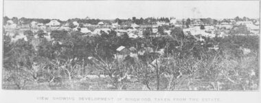
Photograph, Extract from Land Sale Brochure for Pratt's Junction Estate, Ringwood - 1923
... Extract from Land Sale Brochure for Pratt's Junction Estate, Ringwood - 1923. ...Black and white photograph Extract from Land Sale Brochure for Pratt's Junction Estate, Ringwood - 1923. ...Black and white photographTyped note on back of photograph: "Pratt's Junction Estate. Oliver St., Georges Rd., Junction St. 24/11/1923. £3 deposit and £1 per month. F.V. Parker agent. 86 lots. Free rail tickets and motor transport." Typed below photograph: "View showing development of Ringwood. Taken from the Estate." For additional details of Pratts Junction Estate see VC5175a. -
 Ringwood and District Historical Society
Photograph, Extract from Land Sale Brochure for East Ringwood Railway Estate - 1925
... Extract from Land Sale Brochure for East Ringwood Railway Estate - 1925. ...Black and white photograph (2 copies) Extract from Land Sale Brochure for East Ringwood Railway Estate - 1925. ...Black and white photograph (2 copies)Typed below photograph: "Daveys Hill from East Ringwood Railway Station shows the unsurpassable surroundings for this new high and healthy suburb." (Daveys Hill is now Maroondah Hospital ground) For additional details of the East Ringwood Railway Estate Subdivision see VC5135b. -
 Ringwood and District Historical Society
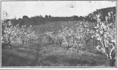
Photograph, Extract from Land Sale Brochure for Coleman's Heathmont Estate, 1923
... Extract from Land Sale Brochure for Coleman's Heathmont Estate, 1923....Black and white photograph (2 images- G0055, G0056) Extract from Land Sale Brochure for Coleman's Heathmont Estate, 1923. ...Black and white photograph (2 images- G0055, G0056)Written on back of image G0055: "Coleman's Heathmont Estate, 15/12/1923. Looking across the estate from Canterbury Rd. Bedford Rd. is seen on the far boundary." For additional details of the Coleman's Heathmont Estate Subdivision see VC5154c. -
 Ringwood and District Historical Society
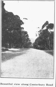
Photograph, Extract from Land Sale Brochure for Coleman's Heathmont Estate, view along Canterbury Road, Heathmont. 1923
... Extract from Land Sale Brochure for Coleman's Heathmont Estate, view along Canterbury Road, Heathmont. 1923. ...Black and white photograph Extract from Land Sale Brochure for Coleman's Heathmont Estate, view along Canterbury Road, Heathmont. 1923. ...Black and white photographWritten on back of photograph: "Coleman's Heathmont Estate. Sale 15/12/1923. Beautiful view along Canterbury Road from corner of Estate." For additional details of Coleman's Heathmont Estate see VC5154c. -
 Sunshine and District Historical Society Incorporated
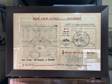
Poster - High View Estate Sunshine Land Sales Poster
... Land Sale...Framed land sale poster. The land for sale is in Sunshine West "Glengala"...Land Sale Poster Sunshine West Glengala High View Estate Sunshine 5 Reasons why you should by now H. ...High View Estate Sunshine 5 Reasons why you should by now H. Scott Propertary Limited|Street names include Ridgeway Parage, Crescent Avenue, Whitesides Avenue, Mary Street, Harold Street, Vernon Crescent, Glengala Road, Lorna Crescent, Murray Street, Daphne Street, Fern Street, James Street, Lawrence Street, Frank Street, Ailsa Street, Norma Crescentland sale, poster, sunshine west, glengala -
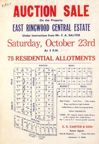 Ringwood and District Historical Society
Flyer, Land Auction Sale Advertisement, East Ringwood Central Estate - 1948
... Land Auction Sale Advertisement, East Ringwood Central Estate - 1948...Single sided land auction sale advertisement for residential allotments....Single sided land auction sale advertisement for residential allotments. ...See Victorian Collections reference 5125 for subsequent Central Estate East Ringwood subdivision flyer.Single sided land auction sale advertisement for residential allotments.Auction Sale on the property under instructions from Mr. F.A. Salter. Subdivision includes Dublin Road, Knaith Road, Talofa Avenue, Russet Road, and Shasta Avenue. Agent - C.E. Carter & Son, Main Street, Ringwood. WU 6024. -
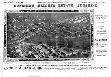 Sunshine and District Historical Society Incorporated
Poster - Sunshine Heights Estate Sunshine Land Sale Poster 1924, 2001
... Sunshine Heights Estate Sunshine Land Sale Poster 1924...... Land Sale...Four photocopies of a poster of land for sale in Sunshine Heights 1924....Sunshine Heights Land Sale Sunshine West Four photocopies of a poster of land for sale in Sunshine Heights 1924. ...sunshine heights, land sale, sunshine west -
Whitehorse Historical Society Inc.
Document, Canterbury Road estate, Unknown
... Plan of subdivision of land for sale in Canterbury Road estate, Blackburn....Whitehorse Historical Society Inc. 2-10 Deep Creek Road Mitcham melbourne land subdivision canterbury road estate blackburn main street norvel street kalka street arna street lalwa street ronley street eustace street Plan of subdivision of land for sale in Canterbury Road estate, Blackburn. ...Plan of subdivision of land for sale in Canterbury Road estate, Blackburn.land subdivision, canterbury road estate, blackburn, main street, norvel street, kalka street, arna street, lalwa street, ronley street, eustace street -
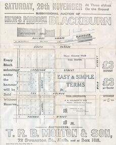 Whitehorse Historical Society Inc.
Document, Kings Padddock Blackburn
... Plan showing land for sale at Kings Paddock, Blackburn (second section)....Whitehorse Historical Society Inc. 2-10 Deep Creek Road Mitcham melbourne auctions kings paddock blackburn south parade laburnum street the avenue fuchsia street laurel grove main street t.r.b. morton & son Plan showing land for sale at Kings Paddock Plan showing land for sale at Kings Paddock, Blackburn (second section). ...Plan showing land for sale at Kings PaddockPlan showing land for sale at Kings Paddock, Blackburn (second section).Plan showing land for sale at Kings Paddockauctions, kings paddock, blackburn, south parade, laburnum street, the avenue, fuchsia street, laurel grove, main street, t.r.b. morton & son -
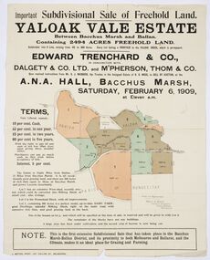 Bacchus Marsh & District Historical Society
Map, Edward Trenchard & Co, Important Subdivisional Sale of Freehold Land Yaloak Vale Estate
... Important Subdivisional Sale of Freehold Land Yaloak Vale Estate...Important Subdivisional Sale of Freehold Land Yaloak Vale Estate...This subdivisional sale of land took place in Bacchus Marsh on the 6th February 1909. ...Land sales advertising poster with map indicating specific lots of land for sale....A good example of land sale maps and advertising material for the district of Bacchus Marsh. ...A land sales map and advertisementLand sales advertising poster with map indicating specific lots of land for sale.A land sales map and advertisementimportant subdivisional sale of freehold land yaloak vale estate, land sales -
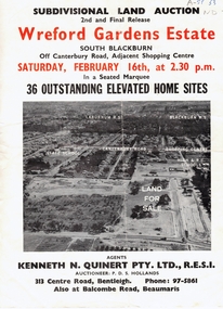 Whitehorse Historical Society Inc.
Document, Wreford Gardens Estate, 1/02/1963 12:00:00 AM
... Pamphlet advertising land for sale on Wreford Gardens Estate, Blackburn 16th February, 1963...Whitehorse Historical Society Inc. 2-10 Deep Creek Road Mitcham melbourne land sales wreford gardens estate blackburn south abercromby road edinburgh road baird court barrina street Wreford Gardens Estate, Pamphlet advertising land for sale on Wreford Gardens Estate, Blackburn 16th February, 1963 Wreford Gardens Estate Document Document ...Wreford Gardens Estate,Pamphlet advertising land for sale on Wreford Gardens Estate, Blackburn 16th February, 1963Wreford Gardens Estate,land sales, wreford gardens estate, blackburn south, abercromby road, edinburgh road, baird court, barrina street -
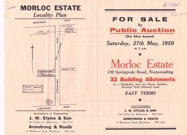 Whitehorse Historical Society Inc.
Document, Morloc Estate
... Advertising brochure, including plan of land for sale in Morloc Estate, Nunawading off Springvale Road...Whitehorse Historical Society Inc. 2-10 Deep Creek Road Mitcham melbourne morloc estate nunawading land subdivision springvale road nunawading Advertising brochure, including plan of land Advertising brochure, including plan of land for sale in Morloc Estate, Nunawading off Springvale Road Morloc Estate Document Document ...Advertising brochure, including plan of landAdvertising brochure, including plan of land for sale in Morloc Estate, Nunawading off Springvale RoadAdvertising brochure, including plan of land morloc estate nunawading, land subdivision, springvale road, nunawading -
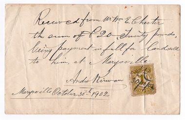 Marysville & District Historical Society
Ephemera (Item) - Land sale certificate, Mr Andrew Kirwan, 30-10-1902
... Land sale certificate......land sale certificate...A land sale certificate between Mr and Mrs E. Chester and Mr Andrew Kirwan dated October 30th, 1902. ...A land sale certificate between Mr and Mrs E. Chester and Mr Andrew Kirwan dated October 30th, 1902. ...The land sold was in Marysville. marysville victoria australia land sale certificate mr and mrs e. chester mr andrew kirwan A land sale certificate between Mr and Mrs E. ...A land sale certificate between Mr and Mrs E. Chester and Mr Andrew Kirwan dated October 30th, 1902. The land sold was in Marysville.A land sale certificate between Mr and Mrs E. Chester and Mr Andrew Kirwan dated October 30th, 1902. The land sold was in Marysville.marysville, victoria, australia, land sale certificate, mr and mrs e. chester, mr andrew kirwan -
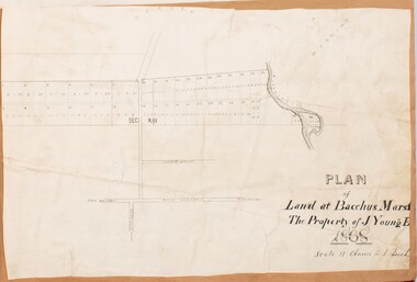 Bacchus Marsh & District Historical Society
Map, Plan of Land at Bacchus Marsh, the Property of James Young, 1868
... Anderson 38 blocks of land which ran from the Lerderderg RIver westwards beyond Gisborne Road in the vicinity of the present day Masons Land. The land for sale was described as, 'unsurpassed Agricultural Land, in the immediate vicinity of Bacchus Marsh, varying in size from 2 to 12 acres each'. ...A single page paper map showing 38 blocks of land for sale in 1868 in the vicinity of Masons Lane Bacchus Marsh. ...Land Sales Bacchus Marsh Bacchus Marsh Victoria Maps James Young 1816-1871 Masons Lane Bacchus Marsh Land Sales A single page paper map showing 38 blocks of land for sale in 1868 in the vicinity of Masons Lane Bacchus Marsh. ...James Young was a prominent businessman, land owner and public figure in the early colonial period of Bacchus Marsh. In February 1868 he offered for sale through the agent W. Anderson 38 blocks of land which ran from the Lerderderg RIver westwards beyond Gisborne Road in the vicinity of the present day Masons Land. The land for sale was described as, 'unsurpassed Agricultural Land, in the immediate vicinity of Bacchus Marsh, varying in size from 2 to 12 acres each'. The sale notice in the Bacchus Marsh Express of 1st February 1868 page 2, also noted that, ' Plans can be seen at Mr. Young's Border Mills Store, and at the Border Inn'. One of the largest and most important land sales in the early colonial period of Bacchus Marsh.A single page paper map showing 38 blocks of land for sale in 1868 in the vicinity of Masons Lane Bacchus Marsh. Scale 11 chains to 1 inch. The map is pasted into a bound volume containing 76 maps or plans in total. High resolution digital image stored on BMDHS computer network. land sales bacchus marsh, bacchus marsh victoria maps, james young 1816-1871, masons lane bacchus marsh land sales -
 Buninyong & District Historical Society
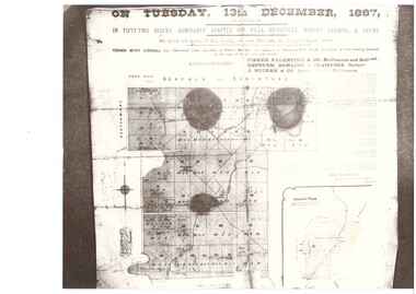
Photograph - Black and White photo land sale advertisement 1887, Advertisement for sale of land from Learmonth's Estate Buninyong 1887
... Black and White photo land sale advertisement 1887...Advertisement for sale of land from Learmonth's Estate Buninyong 1887...An advertisement showing plan of blocks of land for sale from the Learmonth estate in 1887, terms of purchase and locality map ...Buninyong Land sales Learmonth Estate Fisken Family On Tuesday, 13th December 1887 An advertisement showing plan of blocks of land for sale from the Learmonth estate in 1887, terms of purchase and locality map Advertisement for sale of land from Learmonth's Estate Buninyong 1887 Photograph Black and White photo land sale advertisement 1887 ...The advertisement came from the Fisken family Album, Archibald Fisken was an early settler and successful businessmanThe land for sale in this advertisement is from the original Learmonth estate 1838 in Buninyong.An advertisement showing plan of blocks of land for sale from the Learmonth estate in 1887, terms of purchase and locality map On Tuesday, 13th December 1887buninyong, land sales, learmonth estate, fisken family -
 Orbost & District Historical Society
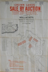
maps, early 1900s
... 796.1 - Crown Land Sale by auction in the township of Mallacoota on Wednesday January 1920 at 2pm. 796.2 - Snowy River farms , 630 acres of river flat land at Orbost on Wednesday April 28, 1909 at 2.30pm. 796.3 - Famous Orbost Flats - "Important Sale of Snowy River Land" , 900 acres subdivided into 13 choice farms on Wednesday 1st December 1920 at 2.30pm. 796.4 - "Second Great Sale in James' Subdivision", adjoining town of Orbost on 16th May, 1919 at 2pm. 796.5 - "Subdivisional Sale Brooklands Estate", 5 rich Snowy River farms on Wednesday 23rd February at 2.30 at Orbost on account of James Hossack Esq. 796.6 - "Subdivisional sale of Splendid Residence Sites and Handy Small Paddocks" adjoining the progressive town of Orbost on 5th March 1915 at 11am at the rooms of H.James & Co. 796.7 - This is a contract drawing on waxed paper. ...A set of twelve maps, plans and land sale posters ....Orbost-land-1900s maps posters H.James A set of twelve maps, plans and land sale posters . maps ...796.1 - Crown Land Sale by auction in the township of Mallacoota on Wednesday January 1920 at 2pm. 796.2 - Snowy River farms , 630 acres of river flat land at Orbost on Wednesday April 28, 1909 at 2.30pm. 796.3 - Famous Orbost Flats - "Important Sale of Snowy River Land" , 900 acres subdivided into 13 choice farms on Wednesday 1st December 1920 at 2.30pm. 796.4 - "Second Great Sale in James' Subdivision", adjoining town of Orbost on 16th May, 1919 at 2pm. 796.5 - "Subdivisional Sale Brooklands Estate", 5 rich Snowy River farms on Wednesday 23rd February at 2.30 at Orbost on account of James Hossack Esq. 796.6 - "Subdivisional sale of Splendid Residence Sites and Handy Small Paddocks" adjoining the progressive town of Orbost on 5th March 1915 at 11am at the rooms of H.James & Co. 796.7 - This is a contract drawing on waxed paper. Crossing near Harbecks Cunninghame Signed and traced N. Anderson 17/11/00. 796.8 - A plan and specification on waxed paper. Shire of Orbost Cunninghame Road - signed by the shire engineer. 796.9 - This is a hand drawn map of Orbost Cunninghame Road, November 1896. 796.10 - This is a hand drawn cross-section of a culvert on the Orbost Cunninghame Road. 796.11 - This is a plan of a culvert on Tabbara Road, 13th January 1899 796.12 - This is a poster for an "Important Subdivisional Sale' for land near Orbost Bridge, on Wednesday 16th March 1921 at the rooms of H. James & Co. These documents are an important part of Orbost history in that they show how the town and surrounding areas were subdivided for farming and residential settlement.A set of twelve maps, plans and land sale posters .orbost-land-1900s maps posters h.james -
 Ringwood and District Historical Society
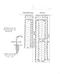
Plan, Paradise Estate Subdivision, Ringwood, Victoria - circa 1925
... Paradise Estate layout also included in Land Sale Brochure Titled Eureka Plan Book - Seven Delightful & Valuable Ringwood Estates - circa 1925, Reg. ...Locality plan showing land for sale south of Canterbury Road, 1 Mile south of Ringwood Railway Station. ...Locality plan showing land for sale south of Canterbury Road, 1 Mile south of Ringwood Railway Station. ...Paradise Estate layout also included in Land Sale Brochure Titled Eureka Plan Book - Seven Delightful & Valuable Ringwood Estates - circa 1925, Reg. No. 5100.Subdivision plan of Paradise Estate, Ringwood, showing allotments for sale, with typed page attached showing block sizes and prices.Locality plan showing land for sale south of Canterbury Road, 1 Mile south of Ringwood Railway Station. Subdivison includes Canterbury Road and Dandenong Road (later Wantirna Road). Surveyors - McKenzie Aisbett & Webber, surveyors & engineers, 440 Little Collins Street, Melbourne, Telephone Central 11540. Subdivision for Mr Grenwood at Ringwood. Additional typewritten price list showing footage, price per foot, and price per block for Lots No. 1 to 60. Paradise Estate layout also included in Land Sale Brochure Titled Eureka Plan Book - Seven Delightful & Valuable Ringwood Estates - circa 1925, Reg. No. 5100. -
 Ringwood and District Historical Society
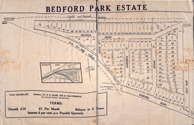
Plan - Sub-division, Bedford Park Estate, Ringwood, Victoria - 1924
... Poster size land sale advertisement....The land adjoining the railway line became parkland with provision for sporting facilities and the remainder was purchased by the Education Department as the site for Ringwood High School/Secondary College. Subdivision plan includes Bedford Road, Graham Road, Joyce Street, Anderson Street, and Adams Street. Solicitors - W.R.R. Blair, Son & Falconbridge, 405 Collins Street, Melbourne. Poster size land sale ...Bedford Park subdivisional development did not eventuate. The land adjoining the railway line became parkland with provision for sporting facilities and the remainder was purchased by the Education Department as the site for Ringwood High School/Secondary College. Poster size land sale advertisement.Subdivision plan includes Bedford Road, Graham Road, Joyce Street, Anderson Street, and Adams Street. Solicitors - W.R.R. Blair, Son & Falconbridge, 405 Collins Street, Melbourne. -
 Sunshine and District Historical Society Incorporated
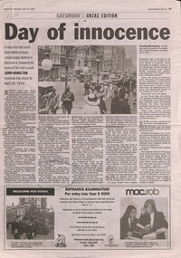
Article - Cost of Land in 1914
... Newspaper article on land sale in Sunshine...Newspaper Article Herald Sun 24 April 204 Day of innocence Newspaper article on land sale in Sunshine Article Cost of Land in 1914 ...Newspaper Article Herald Sun 24 April 204 Day of innocence -
 Bacchus Marsh & District Historical Society
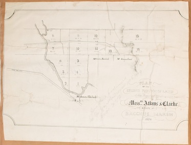
Map, Plan of the second portion of the property of Messers Atkins and Clarke situate at Bacchus Marsh 1856
... This plan of land allotments for sale indicates part of the property once owned by the Bacchus family in and around the township area of Bacchus Marsh. ...A single page paper plan showing allotments of land for sale. The subdivided land shown was owned by John Aitkins and Robert Nalder Clarke, but previously owned by the Bacchus Family and was in and around their Manor House (Mansion) property in Bacchus Marsh. ...Bacchus Marsh & District Historical Society Lerderderg Library Main Street Bacchus Marsh This plan of land allotments for sale indicates part of the property once owned by the Bacchus family in and around the township area of Bacchus Marsh. ...This plan of land allotments for sale indicates part of the property once owned by the Bacchus family in and around the township area of Bacchus Marsh. The Bacchus family sold their property in Bacchus Marsh to John Aitkins and Robert Nalder Clarke in March 1851. Aitkins and Clarke kept the property for a number of years until April 1856 when these allotments were put up for sale.This is a very early land sales plan for agricultural land close to the township of Bacchus Marsh. It therefore provides some clues as to how the early urban development of the township and agricultural development of the nearby area took place. Upon seeing the map in 1911 Bacchus Marsh Express newspaper editor Christopher Crisp wrote "The sale appears to have created the present township, which had a nucleus in earlier times further east", Express, 30 September, 1911, page 3.A single page paper plan showing allotments of land for sale. The subdivided land shown was owned by John Aitkins and Robert Nalder Clarke, but previously owned by the Bacchus Family and was in and around their Manor House (Mansion) property in Bacchus Marsh. This plan shows allotments in the second portion of land to be sold which was located east of the Manor House on the eastern side of the Lerderderg River. The land for sale was made up of 15 allotments. The plan is pasted into a bound volume containing 76 maps or plans in total. BMDHS Loc: AR/B12/S4 Bacchus Marsh Township and Nearby Districts Maps Volume In-house Digital copies: BMDHS, Computer Network: Maps\Bacchus Marsh Township and Nearby Districts Maps Volumebacchus marsh victoria maps, bacchus family, land sales, manor house bacchus marsh