Showing 1002 items matching "land subdivisions"
-
 Glen Eira Historical Society
Document - LAND SUBDIVISIONS 1880-1938
... LAND SUBDIVISIONS 1880-1938...... Land subdivision...This file contains various subdivisions’ advertising flyers and cards. 1/Advertising announcement for auction sale of land (15 lots) at Glenhuntly Tram Terminus, to be held on 29/03/1924. ...A fourth postcard is a map of allotments between Orrong, Kooyong, Seymour and Alison Roads, Caulfield, no date (each 13.5cm x 9cm) 6/Large advertising poster (41cm x 52.5cm) for ‘Carnegie Land Sale’ auction of the Egan Estate (near Carnegie Railway Station) on 12 April, no year given, but appears to be circa1900 7/‘Riddell Estate – Plan of Subdivision – Parish of Prahran’ mounted map, no date, probably c. 1900 (16cm x 21cm) Auctions House auctions Land subdivision Land development Subdivisions Caulfield Land subdivisions East St. ...This file contains various subdivisions’ advertising flyers and cards. 1/Advertising announcement for auction sale of land (15 lots) at Glenhuntly Tram Terminus, to be held on 29/03/1924. Verso is map of the area (21.5cm x 29cm) 2/Advertising announcement for Trustees’ Auction sale of corner shop sites at Caulfield South near Glenhuntly Road and Hawthorn Roads, 15/11/1927 (21cm x 31cm) 3/Advertising pamphlet (A3) for auction of Cantala Estate, East St. Kilda (32 allotments), between Dandenong, Waiora, and Alma Roads, 21/05/1938 (15.5cm x 28.5cm) 4/Seven advertising postcards relating to auctions of land in Caulfield and Elsternwick. Only one (10 December 1881) with a year on it. (Each 13.5cm x 9cm) 5/Four more advertising postcards relating to auctions of land in Caulfield. One is dated 31/11/1880(?); another 09/02/1905. A third has no date. A fourth postcard is a map of allotments between Orrong, Kooyong, Seymour and Alison Roads, Caulfield, no date (each 13.5cm x 9cm) 6/Large advertising poster (41cm x 52.5cm) for ‘Carnegie Land Sale’ auction of the Egan Estate (near Carnegie Railway Station) on 12 April, no year given, but appears to be circa1900 7/‘Riddell Estate – Plan of Subdivision – Parish of Prahran’ mounted map, no date, probably c. 1900 (16cm x 21cm)auctions, house auctions, land subdivision, land development, subdivisions, caulfield, land subdivisions, east st. kilda, glenhuntly, carnegie, map, ‘new glenhuntly tram terminus estate’, ‘cantala estate’, ‘strathnaver estate’, ‘range estate’, ‘egan estate’, ‘riddell estate’ -
Whitehorse Historical Society Inc.
Article, Council rules for land subdivisions, 1976
... Council rules for land subdivisions......Land subdivision...'Know your Council' stating rules and procedures for land subdivision....'Know your Council' stating rules and procedures for land subdivision. Council rules for land subdivisions Article Article ...'Know your Council' stating rules and procedures for land subdivision.'Know your Council' stating rules and procedures for land subdivision.'Know your Council' stating rules and procedures for land subdivision.city of nunawading, land subdivision -
 Ringwood and District Historical Society
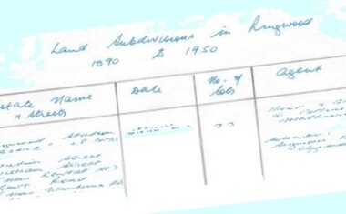
Document - Research Notes, Richard Carter, Land Subdivisions in Ringwood 1890-1950
... Land Subdivisions in Ringwood 1890-1950...£300 Handwritten table listing main local pre-1950s subdivisions in the Ringwood area, with estate names, streets, number of allotments for sale, and where known, vendor agent, LP (Lodged Plan) title registration number, and auction/sale date, some with sale price. Land Subdivisions in Ringwood 1890-1950 Document Research Notes Richard Carter ...Handwritten table listing main local pre-1950s subdivisions in the Ringwood area, with estate names, streets, number of allotments for sale, and where known, vendor agent, LP (Lodged Plan) title registration number, and auction/sale date, some with sale price.Pg1 RINGWOOD STATION ESTATE LP3070 (Year?) Station Street, William Street (now Kendall Street), Wantirna Road, Station Street Pg1 RINGWOOD TOWNSHIP ESTATE LP5577 (1913) Station Road (now Warrandyte Road), Pratt Street (part now Aird Street), Whitehorse Road Pg2 RINGWOOD ORCHARD ESTATE LP4315 (1914) Brysons Road, Hillcrest Road, Anzac Avenue, Sulva Road Pg3 RINGWOOD RAILWAY ESTATE LP7522 (1918) Whitehorse Road (now Mount Dandenong Road), Dublin Road, Freeman Street, Patterson Street, Bona Street Pg4 THE RINGWOOD ESTATE LP7578 (1919) Warrandyte Road, Hobart Street, Paxton Street, Arnold Street Pg5 GARDEN FARMS ESTATE (LP?) (1919) Canterbury Road, Armstrong Road, Bungalook Road, Orchard Road, Bayswater Road (now Mountain Highway) Pg6 THE RINGWOOD ESTATE (SECOND SUB-DIVISION) LP7604 (1919) Warrandyte Road, Tamar Street, Derwent Street, Mersey Street Pg7 RINGWOOD STATION ESTATE LP7703 (1919) Bedford Road, Williams Grove (now Lena Grove) Pg8 RINGWOOD TOWNSHIP ESTATE LP8198 (1919) Wantirna Road, Ellison Street, Haig Street, Greenwood Avenue Pg9 EASTFIELD ESTATE (LP?) (1920) Eastfield Road, Longview Road, Pleasant Rise, The Mount Pg10 ELECTRIC RAILWAY ESTATE RINGWOOD LP9473 (1922) Campbell Street, Myrtle Avenue, George Street (now Tudor Court), Henry Street (now Myrtle Avenue), Williams Grove (now Lena Grove) Pg11 RINGWOOD PARK ESTATE LP7884 (1922 - two stages) Wonga Road (now Loughnan Road), William Street, Andrew Street, Harrison Street Pg12 HEATHMONT STATION ESTATE LP11009 (Date? - after 1922) Lisgoold Street, Viviani Crescent, Balrour Avenue, Station Street (now part Heathmont Road and part Wainui Street) Pg13 RINGWOOD RAILWAY ESTATE LP10507 (1923) Whitehorse Road, Sherbrooke Avenue, Burwood Avenue, Bonview Avenue, Heatherbrae Avenue, Grant Crescent Pg14 GARDEN HOMES ESTATE (LP?) (1923) Mullum Road, The Centreway, Wattle Crescent (now Wattle Avenue) Reserve Crescent (now Reserve Road) Pg15 DUBLIN ROAD ESTATE LP11993 (1923) Alexandra Road, Vonadawn Avenue, Green Street, Wood Street, Howard Avenue, Bedford Road, Dublin Road Pg16 CARLINGA ESTATE RINGWOOD LP9620 (1923) Bourke Street, Bond Street, Ringwood Street Pg17 PRATT'S JUNCTION ESTATE (LP?) (1923) Junction Street, Georges Road, Oliver Street, Whitehorse Road Pg18 EAST RINGWOOD ESTATE LP10492 (1923) Bona Street, Patterson Street, Miller Grove, Fairview Avenue, Eastfield Road, Whitehorse Road (now Mount Dandenong Road) Pg19 COLEMAN'S HEATHMONT ESTATE LP9974 (1923) Canterbury Road, Bedford Road, Alvena Crescent, Coleman Street, Leonard Street (now Royal Avenue) Pg20 RINGWOOD HEIGHTS ESTATE LP10506 (1924) Whitehorse Road, Bonview Avenue, Grant Crescent, Hillcrest Avenue, Heatherbrae Avenue, Margaret Street, Mary Street Pg21 EAST RINGWOOD STATION ESTATE LP10551 (1924) Knaith Road, Wenwood Street, Lois Street, Victoria Street, Station Street (now Railway Avenue) Pg22 GRAND VIEW ESTATE LP11019 (1924) Whitehorse Road, Rupert Street, Herbert Street, Leonard Street Pg23 RINGWOOD RAILWAY ESTATE & RINGWOOD HEIGHTS ESTATE - FINAL SECTIONS LP10506 & LP10507 (1924) Whitehorse Road, Sherbrooke Avenue, Burwood Avenue, Bonview Avenue, Heatherbrae Avenue, Margaret Street, Mary Street, Grant Crescent Pg24 RINGWOOD EAST ELECTRIC STATION ESTATE (LP?) (1924) Railway Parade (now Patterrson Street), Federal Road, Howship Avenue (part now French Street), Dublin Road, Rosedale Crescent Pg25 BEDFORD PARK (now Ringwood Secondary College) (LP?) (1924) Bedford Road, Adams Street, Anderson Street, Joyce Street, Graham Road Pg26 CROWN JEWEL ESTATE LP11645 (Private sales after 1924) Mount Dandenong Road, Mirabel Avenue, Valda Avenue, Evon Avenue, Velma Grove Pg27 GRAND CENTRAL ESTATE LP10917 (1925) Heathmont Road, Great Ryrie Street, Douglas Street, Garden Street, Bellevue Avenue Pg28 RINGWOOD (unnamed estate - 1926) Nelson Street, Seymour Street, Whitehorse Road Pg29 EAST RINGWOOD RAILWAY STATION ESTATE (YEAR? - 25 shops 60 villas) Railway Avenue, Dublin Road, Lawrence Grove, Stanley Avenue, Knaith Road Pg30 CHARM VIEW ESTATE (LP?) (year? - after 1926) Canterbury Road, Heathmont Road, Dickasons Road, Bennjett Avenue, Orchid Street Pg31 SUNBEAM ESTATE LP12150 (Circa 1925) Govt Road (now Old Lilydale Road), Sunbeam Avenue, Holland Road, Everard Street (now Everard Road) Pg32 FAIRVIEW ESTATE EAST RINGWOOD LP10853 (Circa 1924) Eastfield Road, Patterson Street, Margaret Street (now Short Street) Pg33 EAST RINGWOOD TOWNSHIP ESTATE LP3025 (Circa 1924 - 35 allotments) Mount Dandenong Road, Grey Street, Eastfield Road Pg34 EAST RINGWOOD TOWNSHIP ESTATE LP3025 (Circa 1924 - 49 allotments) and STATE SCHOOL ESTATE (26 allotments) and EAST RINGWOOD STATION ESTATE (14 shop sites) Mount Dandenong Road, Grety Street, Dunn Street, Eastfield Road, King Street, Holland Road, Dublin Road, Patterson Street, Bona Street Pg35 EAST RINGWOOD CENTRAL ESTATE LP17004 (1948) Knaith Road, Shasta Avenue, Talofa Avenue, Russet Road, Dublin Road Pg36 WARE ESTATE LP43360 (1958) Ware Crescent, Davey Drive, Grey Road (now Grey Street), Mount Dandenong Road Pg37 Lot 57 Kendall Street LP3070 (1939) £75.0.0 Pg37 Lot 14 LP7346 (year?) £225 Pg37 Lot 8 WHITE HORSE ESTATE LP14010 (year?) Maroondah Hwy, Seymour Street £98.9.0 Pg37 Lots 4-14 incl. LP10902 (year?) £300 Pg37 Lots 69&70 LP2216 (1939) Bedford Road, Pitt Street £500 Pg37 Lots 60&70 LP2216 (year?) £460 Pg37 MOUNTAIN VIEW ESTATE LP10902 (1936) Lots 1&2, 19-22 Wantirna Road, Daisy Street £50 Pg38 RAILWAY STATION ESTATE RINGWOOD EAST LP7522 (1925) Lots 16 to 19 £250 Pg38 RINGWOOD PARK ESTATE (LP?) (1924) Lot 112 Munro Street £230 Pg38 RINGWOOD TOWNSHIP ESTATE (LP?) (1925) Lot 57 Wantirna Road £850 Pg38 ELECTRIC RAILWAY ESTATE LP9473 (1925) Lot 98 & 99 £180 (30/- foot) Pg38 ELECTRIC RAILWAY ESTATE LP9473 (year?) Lot 100 £233.12.6 incl improvements (£2.12.6 foot) Pg38 Lot 22&23 Bedford Road Heathmont (LP & year?) £675 incl improvements Pg39 Lot 9 Mullum Mullum Road LP8221 (1923) £150 Pg39 Lot 27 Haig Street LP8198 (1925) £825 Pg39 Lot 56 Haig Street cnr Wantirna Road LP8198 (1923) £171 Pg39 Lots 3 & 4 Loughnan Road LP9626 (192?) £147 Pg39 Lots 98 & 99 Myrtle Avenue LP9473 (1925) £180 Pg39 Lots 80 & 81 Myrtle Avenue LP9473 (1929) £150 Pg39 Lot 30 Sherbrooke Avenue LP10507 (1926) £700 incl improvements Pg40 Lot 10 (year?) LP7703 £750 Pg40 Lot 36 (year?) LP7522 £25 Pg40 Lot 38 Pitt Street LP2216 (year?) £350 Pg40 Lot 7 Dublin Road cnr Green Street LP11993 (year?) £300 -
Ringwood and District Historical Society
Envelope, Nunawading, Ringwood, East Ringwood Land Subdivision Sales, and Grid Map of Melbourne
... Nunawading, Ringwood, East Ringwood Land Subdivision Sales, and Grid Map of Melbourne...Land Subdivision Sales - Nunawading; Land Subdivision Sales - East Ringwood; Land Subdivision Sales - Ringwood; Land Subdivision Sales - Grid map of Melbourne...Ringwood and District Historical Society 125A Warrandyte Road Ringwood North melbourne Land Subdivision Sales - Nunawading; Land Subdivision Sales - East Ringwood; Land Subdivision Sales - Ringwood; Land Subdivision Sales - Grid map of Melbourne Nunawading, Ringwood, East Ringwood Land Subdivision Sales, and Grid Map of Melbourne Envelope ...Land Subdivision Sales - Nunawading; Land Subdivision Sales - East Ringwood; Land Subdivision Sales - Ringwood; Land Subdivision Sales - Grid map of Melbourne -
Glen Eira Historical Society
Document - Vadlure Avenue, 2, St. Kilda East
... ... Land Subdivisions...Printed and handwritten research from Brighton Historical Society giving brief details on 2 Vadlure Avenue, regarding subdivision of land formerly grounds of Kilwinning and residents of property from 1931 to 1974. ...Kilda East Service James Land Subdivisions 'Kilwinning' Denman Street Kosky Samuel McArdle Daniel J. ...Printed and handwritten research from Brighton Historical Society giving brief details on 2 Vadlure Avenue, regarding subdivision of land formerly grounds of Kilwinning and residents of property from 1931 to 1974. Dated 19/01/1988.vadlure avenue, st. kilda east, service james, land subdivisions, 'kilwinning', denman street, kosky samuel, mcardle daniel j., elisha e., elisha d., bullock h., landells rosalind -
 Glen Eira Historical Society
Photograph - NETTALIE
... ... Land subdivisions...Shaw Herbert Shaw Alfred Henry Shaw Arthur Shaw Amelia Shaw Lavinia Forsyth William Blundell Mary Fosbery John Bakewell John Hailes George B Blundell Miss Stephen George Sir Billings Richard Ware Martha Desailly Alfred Cameron William Dr Cameron J Mrs Nettalie The Nest Netley House House names Caulfield North Balaclava Road Grimwade House Orrong Road Harleston Caulfield Road District St Kilda East The Curragh Shelford Helenslea Sylliot Hall Labassa O’Loughlin Street Ormond Hotham Street Melbourne Grammar School Caulfield Conservation Study Mansions Teachers Schools Independent schools Hardware stores Business people Lawyers Businesses Brick houses Outbuildings Architectural styles Classrooms Bunya bunya pine trees Trees Orchards Land subdivisions Land sales Doctors Photograph NETTALIE ...Various documents about and photographs of Nettalie or Netley House or The Nest on Balaclava Road Caulfield now part of Melbourne Grammar School: 1/The first is an article undated and unattributed accessed from Beresford.org on 14/07/2006 detailing with bibliography the history of Netley House including the owners especially the Shaw family. 2/There are several separately colour-printed photographs of the front facade of Nettalie most undated and unattributed, and one family portrait of the Shaw family circa 1863. All were also accessed from Beresford.org on 14/07/2006. 3/One black and white photograph is inscribed '73 Balaclava Rd Caulfield 3/9/72 Neg 16A'. 4/Two copies of a plan of Nettalie next to The Curragh and Harleston, also in the article and likely accessed from same source on same date. 5/A copy of Dr Cameron’s letter to Herbert Shaw dated 24/05/1949. 6/One copy of a letter from Herbert Shaw to Dr William Cameron dated 25/05/1949. 7/A plan of Melbourne Grammar School with each building dated to when it was built including Netley House in 1863.shaw herbert, shaw alfred henry, shaw arthur, shaw amelia, shaw lavinia, forsyth william, blundell mary, fosbery john, bakewell john, hailes george b, blundell miss, stephen george sir, billings richard, ware martha, desailly alfred, cameron william dr, cameron j mrs, nettalie, the nest, netley house, house names, caulfield north, balaclava road, grimwade house, orrong road, harleston, caulfield road district, st kilda east, the curragh, shelford, helenslea, sylliot hall, labassa, o’loughlin street, ormond, hotham street, melbourne grammar school, caulfield conservation study, mansions, teachers, schools, independent schools, hardware stores, business people, lawyers, businesses, brick houses, outbuildings, architectural styles, classrooms, bunya bunya pine trees, trees, orchards, land subdivisions, land sales, doctors -
Glen Eira Historical Society
Plan - Nettalie
... ... Land subdivisions...Caulfield Caulfield North Elsternwick St Kilda East Parish of Prahran Parish of Moorabbin Caulfield Road District Melbourne and Brighton Railway Rosstown Railway Elsternwick Railway Station Caulfield Railway Station Rosstown Railway Station Murrumbeena Railway Station Baptist Church Paddy’s Swamp reserve Cemetery Reserve Leman Swamp Reserve Caulfield Racecourse Reserve Brighton Cemetery The Vine Caulfield Hotel The Tam O’Shanter Hotel Melbourne Hunt Hotel Royal Hotel Hotham Street Horne Street Nepean Highway North Road Orrong Road Dandenong Road Princes Highway Kooyong Road Alma Road Inkerman Road Balaclava Road Glen Eira Road Glen Huntly Road Hawthorn Road Cemetery Road Bambra Road Redan Road Kambrook Road Neerim Road Booran Road Racecourse Road Grange Road Koornang Road Murrumbeena Road Crosbie Road Kangaroo Road Poath Road Ford W Lempriere Cople J Riddell J C Manifold J Testar T Billing R H Semple Blundell Shaw A Butchart G Stephen J W Stephen G Sir Hart J Duncan G Blackie R Stephen F McCombie T Woollaston H Higgins J Lloyd J C Daish J McLeod J Hughes D Wilson A Jamieson G Webb G H Renwick S Pennington H Dunn J Kirkpatrick W Ricketson W Toad A Sayce J Watts T Widgery Store Guess J Anketell J Clack J Sissen W Clayton G Dickson D Bevan J Hart T Anderson J Hart Mrs Webb H Masters S Waghorn J Hemming C Hiam C Farquhar W Newing T Payne T Cooper R Snipe S Chambers J Forster W Summers R Harriman B Warrick O’Connell Long J Peck R Cochrane C Murray Ross W Evans C Kennedy J Maclean N Forster Lyall W Dean J Newton H Looker W Baker C Johnston Crosbie J Kerr Jones Parr Nelson C Montgomery L Parsons W James J C Sibon C Smith Sydney W Plans Maps Land subdivisions Land use Settlements Roads and streets Hotels Churches Police stations Post offices Land surveys Railway stations Railways Schoolhouses Commerce Clergy residences Official buildings Local government Road districts Plan Nettalie ...An A4 photocopy of the 'Plan of the Caulfield Road District' dated 1867. This plan shows the location of the properties owned by A Shaw and Blundell on Balaclava and Orrong Roads where Nettalie is situated. The plan includes all the landowners listed where their property was, the street names and other landmarks of 1867 including railways, hotels and reserves.caulfield, caulfield north, elsternwick, st kilda east, parish of prahran, parish of moorabbin, caulfield road district, melbourne and brighton railway, rosstown railway, elsternwick railway station, caulfield railway station, rosstown railway station, murrumbeena railway station, baptist church, paddy’s swamp reserve, cemetery reserve, leman swamp reserve, caulfield racecourse reserve, brighton cemetery, the vine caulfield hotel, the tam o’shanter hotel, melbourne hunt hotel, royal hotel, hotham street, horne street, nepean highway, north road, orrong road, dandenong road, princes highway, kooyong road, alma road, inkerman road, balaclava road, glen eira road, glen huntly road, hawthorn road, cemetery road, bambra road, redan road, kambrook road, neerim road, booran road, racecourse road, grange road, koornang road, murrumbeena road, crosbie road, kangaroo road, poath road, ford w, lempriere, cople j, riddell j c, manifold j, testar t, billing r h, semple, blundell, shaw a, butchart g, stephen j w, stephen g sir, hart j, duncan g, blackie r, stephen f, mccombie t, woollaston h, higgins j, lloyd j c, daish j, mcleod j, hughes d, wilson a, jamieson g, webb g h, renwick s, pennington h, dunn j, kirkpatrick w, ricketson w, toad a, sayce j, watts t, widgery, store, guess j, anketell j, clack j, sissen w, clayton g, dickson d, bevan j, hart t, anderson j, hart mrs, webb h, masters s, waghorn j, hemming c, hiam c, farquhar w, newing t, payne t, cooper r, snipe s, chambers j, forster w, summers r, harriman b, warrick, o’connell, long j, peck r, cochrane c, murray ross w, evans c, kennedy j, maclean n, forster, lyall w, dean j, newton h, looker w, baker c, johnston, crosbie j, kerr, jones, parr, nelson c, montgomery l, parsons w, james j c, sibon c, smith sydney w, plans, maps, land subdivisions, land use, settlements, roads and streets, hotels, churches, police stations, post offices, land surveys, railway stations, railways, schoolhouses, commerce, clergy residences, official buildings, local government, road districts -
Glen Eira Historical Society
Plan - Pascoe Avenue, 26, Bentleigh
... ... Land Subdivisions...The 1954 documents were clearly used in the 1957 valuation. Pascoe Ave Land Subdivisions Land Values Bentleigh Pergolas Architectural features Parish of Moorabbin Plans Architectural styles County of Bourke Maps Brick Houses National Trustees Co Illustrations Dendy’s Crown Special Survey Plan Pascoe Avenue, 26, Bentleigh ...Document detailing two valuations by National Trustees Co of the property at 26 Pascoe Ave, Bentleigh, the first valuation is dated 14/07/1954 and the second dated 19/07/1957. Included are handdrawn plans, handwritten notes and typed valuations listing values of architectural features, and correspondence from National Trustees Co. for both 1954 and 1957. The 1954 documents were clearly used in the 1957 valuation.pascoe ave, land subdivisions, land values, bentleigh, pergolas, architectural features, parish of moorabbin, plans, architectural styles, county of bourke, maps, brick houses, national trustees co, illustrations, dendy’s crown special survey -
 Greensborough Historical Society
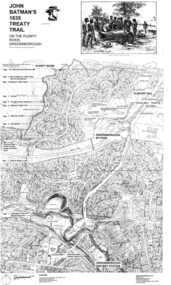
Map, Dennis Ward, John Batman's 1835 Treaty Trail on the Plenty River, 2010_
... Large laminated map, including land subdivisions and street names....This map shows many places of interest along the Plenty River. plenty river heritage trail Large laminated map, including land subdivisions and street names. John Batman's 1835 Treaty Trail on the Plenty River Map Dennis Ward ...Map of the Plenty River through Greensborough and surrounding areas, annotated with historic places. Prepared by Dennis Ward, this map shows places of interest with historic markers for a proposed Heritage Trail along the Plenty. This was a joint project of Dennis Ward, Rotary Greensborough and Nillumbik Historical Society.This map shows many places of interest along the Plenty River. Large laminated map, including land subdivisions and street names.plenty river heritage trail -
 Ringwood and District Historical Society
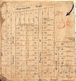
Map, Residential Subdivision Allotment Layout on Mullum Mullum Road, Hobart Street, Paxton Street, Arnold Street and Warrandyte Road, Ringwood, Vic. circa 1920
... One of 3 unrelated land subdivision maps on cardboard backing....One of 3 unrelated land subdivision maps on cardboard backing. Residential Subdivision Allotment Layout on Mullum Mullum Road, Hobart Street, Paxton Street, Arnold Street and Warrandyte Road, Ringwood, Vic. circa 1920. ...One of 3 unrelated land subdivision maps on cardboard backing.H.C. Crouch, Licensed Surveyor, 443 Lt Collins Street, Melbourne. -
Tatura Irrigation & Wartime Camps Museum
Poster, Subdivision of Township Allotments
... ...land subdivision...Shows map of land subdivision....Advertising land subdivision for sale in the township of Rushworth. ...Poster depicting the land which was being sold by J S Darby on the 3 December 1890. Auctioneer was Martin Cussen and Co. Map shows location of land.Single sheet of paper, laminated. Advertising land subdivision for sale in the township of Rushworth. Being sold by Martin Cussen and Co, auctioneers for J S Darby. Shows map of land subdivision.rushworth, land subdivision, martin cussen and co, j s darby -
Glen Eira Historical Society
Letter - Rosstown Railway
... ... Land Subdivisions...RETURN TO ROSSTOWN: RAILWAYS LAND SALES AND SUGAR BEET VENTURES IN CAULFIELD Land Sales Walking Trails Ross William Murray Transport Objects Locomotion Walking Cycling Driving Sports Country Mansions People Caulfield John Builders Construction and Demolition Workers Occupations Careers Professionals Topography Geology Landforms Horticulture Market Gardens Primary Industry Workers City of Caulfield MOOD KEE Pennington Harold Annual General Meetings Caulfield Town Hall Glen Eira City Council Carnegie Carnegie Station Rosstown Station People by Circumstance Migrants Sugar Beet Sugar Beet Mill Sugar Beet Industry Mills Factories SEA BEACH LINES Bent Thomas Parliamentary Representatives Neville Street Miller Street Lemann’s Swamp Reserve Koornang Park Cane Sugar Industry Breweries Rabbit Processing Plants Health Establishments Hospitals Food Production Establishments Abattoirs Thieves Social Problems Vagrants Theft Squatting Financial Economics Debt Finance Industry Insurance Companies Company Managers Bentleigh Ross Leila THE GRANGE Leila Road Wild Cherry Road Financial Trouble Mortgages Gisborne Street Archibald Street Riddell Parade VICTORIA RAILWAYS Glen Huntly Road Clarence Street College Street Gladstone Parade Parrell Street Aileen Avenue Seaview Street Land Subdivisions Dover Street Sussex Street Landfill Marara Road Booran Road Woodville Avenue Dorothy Avenue Ormond Park Royal Avenue Ormond Railway Station Oakleigh Road Melten Avenue Miller Street Munro Avenue Lord Reserve Neerim Road Toolambool Road The Rosstown Hotel Rosanna Street Murrumbeena Crescent Commercial Establishments The National Bank Rosstown Road Kangaroo Road Poath Road Freda Street Hughesdale Kindergarten Oakleigh Council Hughesdale Community Centre Civic Establishments Galbally Reserve Plaques Warrigal Road OUT AND ABOUT BROCHURES Orion Estate Letter Rosstown Railway ...This file contains four items: 1/A black and white photocopy of a letter dated either 07/08/1889 or 09/08/1889, from Robert Lundon to an unidentified recipient discussing an agreement reached between the author – on behalf of the recipient – and Soon Hang Hi in regard, in regards to the allotment known as Webber’s. The agreement is outlined in the letter in what appears to be Chinese characters, and includes the marks of Robert Lundon and Soon Hang Hi. File note from Joy Wu states that the calligraphy is not Mandarin or traditional Chinese. 2/Three sheets of hand-written working notes with information taken from the Victorian Government Gazette on THE ROSSTOWN AND MURRUMBEENA LAND COMPANY LIMITED, THE ROSSTOWN JUNCTION RAILWAY AND PROSPERITY COMPANY LIOMITED, and THE ROSSTOWN JUNCTION, ELSTERNWICK, AND OAKLEIGH RAILWAY COMPANY LIMITED, covering dates between 1887 and 1894. The notes concern meetings and creditors claims relevant to the companies, with reference numbers for the information source. Date and author of the notes are not recorded. 3/A black and white photocopy of the a partial map of the Rosstown Railway and surrounding area, undated. The map includes the names of landholders in the areas of Brighton, Garden Vale and Elsternwick, as well as other railway lines present in the region. 4/A fold-out map and guide of the Rosstown Rail Trail, including a brief general history of Caulfield as well as a more extensive biography of William Murray Ross and the Rosstown Railway. The map marks and describes significant sites along the trail, including photographs of some of these sites, provided by DF Jowett.documents, correspondence, webber’s, lundon robert, chinese characters, ethnic communities, signatures, text, settlements, taxes, fraser john grieves, lovell r.h., price davies, meetings, communication activities, soon hang hi, commercial events and activities, the rosstown and murrumbeena land company limited, victorian government gazette, bulmer richard, parry john, osment henry, shareholders, creditors claims, the rosstown junction railway and property company limited, finch and best, lawyers, the rosstown junction elsternwick and oakleigh railway company limited, cameron w.c., phillips p.d., garden vale, elsternwick, elsternwick railway station, rosstown, rosstown railway, thomas street, bay street, kooyong road, melbourne and brighton railway, hawthorn road, bambra road, caulfield and frankston railway, booran road, grange road, koornang road, murrumbeena road, north road, north road railway station, east brighton railway station, south road, railway routes, railway lines, railways, land transport, murphy j., caulfield, hamilton t.f., dane p., holloway, webb, ailee john, payne t.b., brodie chas, dane john, o’neil h., mccombie john, mcmillane a., smyth c.d., cooper, ebden, landholders, jeffrey j.d., gill j., balcombe a.e., cooper h., mcnab j., white j., sutherland j., greeves a.f.a., newton m.c., chamley f.b., fowler j., inglis p., grant t., stooke j., swanson g., cochrane c., adams e.b., mccombie thas, keyes robert, brighton cemetery, burials grounds and graveyards, war-ein road, were j.b., holland j., mcmahon c., winter t.l.m., dendy henry, mitchell w., jackson s., were j.e., wickham francis dawe, bryant jane, east brighton railway station, railway stations, maps, allotments, land titles, roads and streets, rosstown rail trail, city of glen eira, tourism, trains, tourism information bureaus, tours, pamphlets, elsternwick railway park, oakleigh junction, princes park, ee gunn reserve, packer park, sites, jowett d.f., weickhardt i.g., return to rosstown: railways land sales and sugar beet ventures in caulfield, land sales, walking trails, ross william murray, transport objects, locomotion, walking, cycling, driving, sports, country mansions, people, caulfield john, builders, construction and demolition workers, occupations, careers, professionals, topography, geology, landforms, horticulture, market gardens, primary industry workers, city of caulfield, mood kee, pennington harold, annual general meetings, caulfield town hall, glen eira city council, carnegie, carnegie station, rosstown station, people by circumstance, migrants, sugar beet, sugar beet mill, sugar beet industry, mills, factories, sea beach lines, bent thomas, parliamentary representatives, neville street, miller street, lemann’s swamp reserve, koornang park, cane sugar industry, breweries, rabbit processing plants, health establishments, hospitals, food production establishments, abattoirs, thieves, social problems, vagrants, theft, squatting, financial economics, debt, finance industry, insurance companies, company managers, bentleigh, ross leila, the grange, leila road, wild cherry road, financial trouble, mortgages, gisborne street, archibald street, riddell parade, victoria railways, glen huntly road, clarence street, college street, gladstone parade, parrell street, aileen avenue, seaview street, land subdivisions, dover street, sussex street, landfill, marara road, booran road, woodville avenue, dorothy avenue, ormond park, royal avenue, ormond railway station, oakleigh road, melten avenue, miller street, munro avenue, lord reserve, neerim road, toolambool road, the rosstown hotel, rosanna street, murrumbeena crescent, commercial establishments, the national bank, rosstown road, kangaroo road, poath road, freda street, hughesdale kindergarten, oakleigh council, hughesdale community centre, civic establishments, galbally reserve, plaques, warrigal road, out and about brochures, orion estate -
Glen Eira Historical Society
Map - CAPLES PLACE SUBDIVISION
... Land Subdivisions...The map provides the dimensions of roads and allotments in the area, including also handwritten notes from the original document and others written directly onto the copy. Land Subdivisions Documents Maps Glen Eira CAPLES PLACE CAPLES PLACE Subdivision Land Surveys Orrong Road Mulgrave Road Prahran Grove Somerset Road Prahran Grove Prahran Grove East Walk Land Allotments Town Planning Garden Road Map CAPLES PLACE SUBDIVISION ...This file contains a copy of a map of the CAPLES PLACE SUBDIVISION, undated and author unknown. The map provides the dimensions of roads and allotments in the area, including also handwritten notes from the original document and others written directly onto the copy.land subdivisions, documents, maps, glen eira, caples place, caples place subdivision, land surveys, orrong road, mulgrave road, prahran grove, somerset road, prahran grove, prahran grove, east walk, land allotments, town planning, garden road -
 Glen Eira Historical Society
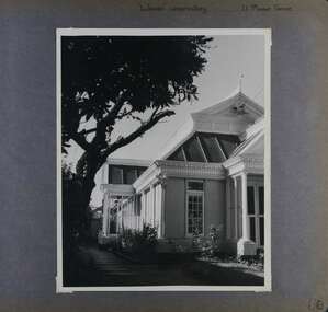
Album - Album page, Labassa Conservatory, 21 Manor Grove, Circa 1972
... ...land subdivisions...This building is unusual as an example converted to residential use. bracketed eaves caulfield north labassa balaclava road orrong road sylliott hill alexander william robertson ontario john a. b. koch john boyd watson mouldings 1920's la bassa manor grove st kilda east architects john koch greenhouses gardens plants land subdivisions gates macfarlane foundry brick cast iron work hipped roofs gables 1890's Handwritten: "Labassa" conservatory 21 Manor Grove [top right] /130 [bottom right] Page 130 of Photograph Album with one portrait photograph of Labassa's conservatory. ...This photograph is part of the Caulfield Historical Album 1972. This album was created in approximately 1972 as part of a project by the Caulfield Historical Society to assist in identifying buildings worthy of preservation. The album is related to a Survey the Caulfield Historical Society developed in collaboration with the National Trust of Australia (Victoria) and Caulfield City Council to identify historic buildings within the City of Caulfield that warranted the protection of a National Trust Classification. Principal photographer thought to be Trevor Hart, member of Caulfield Historical Society. Most photographs were taken between 1966-1972 with a small number of photographs being older and from unknown sources. All photographs are black and white except where stated, with 386 photographs over 198 pages. WHAT IS SIGNIFICANT? [From Victorian Heritage Database citation for Former Labassa Conservatory - H2005 Victorian Heritage Register http://vhd.heritage.vic.gov.au/places/result_detail/12504 (25/01/2021)] The former Labassa Conservatory is believed to have been built as part of the extensive reworking of the Labassa estate in c1890 for the new owner Alexander Robertson, proprietor of the Cobb and Co line. Robertson commissioned the architect JAB Koch to remodel the house, and Koch may have been responsible for the conservatory as well. Alternatively, the conservatory may have been imported. The gates installed at Labassa in 1890 were manufactured by the MacFarlane foundry of Glasgow, Scotland, a firm known to have manufactured conservatories. Around 1917 the glass house from 'Labassa', Caulfield was offered for sale to Malvern Council for its own gardens but the offer was declined. Following subdivision of the Labassa estate in the 1920s the conservatory was converted into a residence. The structure has a simple rectangular plan, with a brick base and superstructure of cast iron columns and roof trusses. The hipped roof is surmounted by an elaborately decorated gable structure. Most of the original glass has been replaced by metal sheeting. The decoration comprises pressed metal fascias including an egg and dart style cornice moulding, mullion mouldings and gable end panels with a rising sun motif. Cast iron ridgework and finials add to the lively roof form. Internally the floor appears to have been raised as part of the conversion work to a residence, and stained timber panelling introduced to provide room spaces. Boilers probably heated the conservatory in the colder months, but these do not survive.From Victorian Heritage Database citation for Former Labassa Conservatory - H2005 http://vhd.heritage.vic.gov.au/places/result_detail/12504 (25/01/2021) HOW IS IT SIGNIFICANT? The former Labassa Conservatory is of historical and architectural significance to the State of Victoria. WHY IS IT SIGNIFICANT? The former Labassa Conservatory is historically significant for its associations with the Labassa estate. Subdivision of the estate separated a number of outbuildings from the mansion. The former conservatory is significant as part of the large scale improvements carried out to the estate in the 1890s. The nineteenth century was the great age of conservatory designs, enabled by technological developments in heating, glazing and iron. Whilst conservatories were common in botanical gardens and universities, where they were primarily used for cultivating, studying, and experimenting with plants, they had also become an accessory of the wealthy on private estates. The former Labassa conservatory is architecturally significant as a rare example of a building type. Many Victorian mansion houses had attached conservatories, but detached conservatories were much less common. The only other detached example associated with a residence known to survive on its original site in Victoria is an earlier example at Warrock homestead, near Casterton. Conservatories attached to nineteenth century mansions are far more numerous. The Labassa example is very ornate, and its decoration draws on the versatility of pressed metal and cast iron. This highlights the dual purpose of the conservatory, as both a functional structure and a picturesque building on the Labassa estate. This building is unusual as an example converted to residential use. Page 130 of Photograph Album with one portrait photograph of Labassa's conservatory.Handwritten: "Labassa" conservatory 21 Manor Grove [top right] /130 [bottom right]bracketed eaves, caulfield north, labassa, balaclava road, orrong road, sylliott hill, alexander william robertson, ontario, john a. b. koch, john boyd watson, mouldings, 1920's, la bassa, manor grove, st kilda east, architects, john koch, greenhouses, gardens, plants, land subdivisions, gates, macfarlane foundry, brick, cast iron work, hipped roofs, gables, 1890's -
Glen Eira Historical Society
Document - Villiers Street, 2, Elsternwick
... ... Land Subdivisions...Villiers Street Elsternwick Land Subdivisions Hendrick John Robertson George Gillespie J. ...Printed and handwritten duplicated copy on the history of Villiers Street by Hilary Bullock. Also gives names of tenants and property owners from 1892 to 1974. Brief description of house interior.villiers street, elsternwick, land subdivisions, hendrick john, robertson george, gillespie j., haines w., johnson charles, reeves christine, quinlan john f., quinlan william, wykes leonard, wykes i.f., tarrant george, laity r.j., thout r. zoe -
Glen Eira Historical Society
Letter - Lirrewa
... ... Land subdivisions...Lirrewa Lirrewa Grove O’Donnell J Fulton Thomas Land subdivisions Glen Eira Road Glen Huntly Road Kooyong Road Tennant Dr Cox James Dr Brooks Walter Richard Baby health care Bryce Percy H Sylverly House names Market gardens Chinese community Langdon Montague William Langdon Henry Joseph Rosecraddock Langdon Elizabeth Tarqua St Marys church Caulfield Hawthorn Road Lirrewa Grove Stables Architectural features Brooks Gladys Brooks Walter Councillors Scott Robert Redcliff Mr Architects McCulloch Mr Teachers Office workers Farmer Mr Ward Andrew Mansions Verandahs Slate tiles Fountains Leadlights Fireplaces Grant RS Black RS Anderson P Russell Edwin R Cast ironwork Flats Marble Mantel pieces Gothic revival style Brick Arches Letter Lirrewa ...Four articles on Lirrewa’s history, conservation study and notes on architectural features and correspondence from National trust to Mrs W Brooks. Photocopy of an extract from Caulfied Historical Newsletter (No 4 April 1973) containing 2 articles about Lirrewa and Caulfield (one by J O’Donnell, one by Mrs AP Bell) Photocopied extract from the Caulfield Conservation study detailing history and features of Lirrewa written by Andrew Ward (January 1995) Handwritten notes on architectural features of home and hand drawn designs of side and centre windows and design above all main room doors. Includes typed directory listings from 1886 to 1921. Date and author unknown Copy of correspondence to Mrs W Brooks from the Administration National Trust of Australia regarding classification Lirrewa 20/03/1973 and stables.lirrewa, lirrewa grove, o’donnell j, fulton thomas, land subdivisions, glen eira road, glen huntly road, kooyong road, tennant dr, cox james dr, brooks walter richard, baby health care, bryce percy h, sylverly, house names, market gardens, chinese community, langdon montague william, langdon henry joseph, rosecraddock, langdon elizabeth, tarqua, st marys church, caulfield, hawthorn road, lirrewa grove, stables, architectural features, brooks gladys, brooks walter, councillors, scott robert, redcliff mr, architects, mcculloch mr, teachers, office workers, farmer mr, ward andrew, mansions, verandahs, slate tiles, fountains, leadlights, fireplaces, grant rs, black rs, anderson p, russell edwin r, cast ironwork, flats, marble, mantel pieces, gothic revival style, brick, arches -
 Glen Eira Historical Society
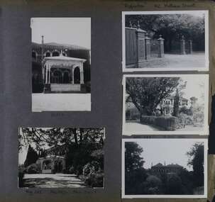
Album - Album page, Ripponlea, 192 Hotham Street, Circa 1972
... ...land subdivisions...It was built about 1884. trevor hart elsternwick mansion hotham street frederick sargood reed and barnes cast iron porte cochere conservatory 1860's 1890's ballroom 1880's benjamin nathan louisa jones thomas bent sir thomas bent william guilfoyle adam anderson lake grotto shade house portico ripponlea victorian sir frederick sargood architects polychrome bricks lombardic romanesque architectural style rippon lea taylor and fitts land subdivisions gardens drives vegetable gardens orchards Handwritten: "Ripponlea" 192 Hotham Street [top right] / North [under top left photo] / Neg 255 Dec 1972 MAIN DRIVE [under bottom left photo] / Neg 238 8 OCT 1966 [under middle right photo] / 88 [bottom right] Page 90 of Photograph Album with five photographs (one landscape and 4 portrait) of Ripponlea - two different views of the front entrance to the mansion, one of the front gates and two different views of the main residence. ...This photograph is part of the Caulfield Historical Album 1972. This album was created in approximately 1972 as part of a project by the Caulfield Historical Society to assist in identifying buildings worthy of preservation. The album is related to a Survey the Caulfield Historical Society developed in collaboration with the National Trust of Australia (Victoria) and Caulfield City Council to identify historic buildings within the City of Caulfield that warranted the protection of a National Trust Classification. Principal photographer thought to be Trevor Hart, member of Caulfield Historical Society. Most photographs were taken between 1966-1972 with a small number of photographs being older and from unknown sources. All photographs are black and white except where stated, with 386 photographs over 198 pages.From Victorian Heritage Database citation for Rippon Lea H0614 https://vhd.heritagecouncil.vic.gov.au/places/427(as at 23/10/2020) Rippon Lea was commenced in 1868 by Frederick Sargood, a most successful politician and merchant. He was born in England in 1834 and arrived in Melbourne in 1850. He soon joined his father's wholesale soft goods firm, spending some time as its manager on the goldfields. Sargood entered the Legislative Council in 1874. He was Victoria's first Minister for Defence in 1883. Sir Frederick Sargood was created CMG. In 1885 and KCMG in 1890 as a reward for his contribution to public life. He died suddenly in 1903. Rippon Lea was designed by the leading firm of architects, Reed and Barnes. Joseph Reed had travelled in Europe in 1863, including northern Italy. When he returned he introduced the use of polychromy. While not the first examples, Rippon Lea and the Independent Church in Collins Street were the best and set a fashion which became a distinctly Melbourne style, particularly used for houses and churches. Its popularity was possible because of the new availability of different coloured bricks. Reed's fine Lombardic Romanesque details soon became debased by others. As Sargood's family grew and his fortunes prospered, Rippon Lea was extended to include 33 rooms - a complete mansion. The cast iron porte cochere and the northern conservatory were added in 1897. The architects were Taylor and Fitts. The ballroom was added in 1882 and remodelled in 1889. Many alterations have changed the interior and exterior during the ownerships of Benjamin Nathan and later his daughter Mrs Louisa Jones in the 1930s and are in their own right of significance. Sir Thomas Bent owned the property from 1903 until 1911 but never lived there. He subdivided much of the land. The original garden dates from about 1868, and it seems that William Guilfoyle of the Botanic Gardens was involved. It was redesigned in a more natural style in the 1880s by Sargood and his head gardener, Adam Anderson. The lake, waterfalls, fernery, hill and grotto are balanced by mighty deciduous trees and conifers. These are interspersed with, but never dominated by Australian species such as eucalyptus and other exotics. The sinuous drive with its carefully prepared approach to the house is notable. The original vegetable gardens, orchard and outer paddocks no longer survive. The shade house is important as the largest known in Australia and possibly the world. Its curved plan and form of construction are particularly notable. It was built about 1884.Page 90 of Photograph Album with five photographs (one landscape and 4 portrait) of Ripponlea - two different views of the front entrance to the mansion, one of the front gates and two different views of the main residence.Handwritten: "Ripponlea" 192 Hotham Street [top right] / North [under top left photo] / Neg 255 Dec 1972 MAIN DRIVE [under bottom left photo] / Neg 238 8 OCT 1966 [under middle right photo] / 88 [bottom right]trevor hart, elsternwick, mansion, hotham street, frederick sargood, reed and barnes, cast iron porte cochere, conservatory, 1860's, 1890's, ballroom, 1880's, benjamin nathan, louisa jones, thomas bent, sir thomas bent, william guilfoyle, adam anderson, lake, grotto, shade house, portico, ripponlea, victorian, sir frederick sargood, architects, polychrome bricks, lombardic romanesque architectural style, rippon lea, taylor and fitts, land subdivisions, gardens, drives, vegetable gardens, orchards -
Glen Eira Historical Society
Article - Attwood Family
... ... Land Subdivisions...Timber Houses Outbuildings Artists Trains Car Parks Christie’s Woodyard Ferguson Cam Railway Accidents Ardyne Street North Road Dalny Road Brett Street Barnes Family Newspapers Roads and Streets Soils Flower Growing Market Gardens World War 1939-1945 Land Subdivisions Air Raid Precautions Bicycles Drawing Springthorpe Park Mass Media Murrumbeena Shopping Centre Butcher Shops Grocer Shops Green Grocers Shoe Shops Confectionary Shops Barber Shops Beck George Bowyer Ralph Rennie Bill Bookmakers Presbyterian Church Methodist Church Hanna’s Milk Bar Sunday School Woodland Bill SSW Grocery Chain Drays Woodland Alec Lee Ron Jewellers Bakeries Fish Shops Dressmakers Delicatessens East Bentleigh Selkrigs Family Pottery Heads’ Garage Head Lindsay Head Doug Head Clarry Head Ron Murrumbeena Road Car Retailers Petrol Pumps Motor Vehicle Repair Shops Billy One Motors Bird Mr. ...Two items about the Attwood Family: A seventeen page computer typed copy of the memories of John Attwood, compiled by Colin Smith in January 2002. Includes memories of his childhood, contact and impressions of local identities including Merric Boyd and others; the retailers and business owners in the Murrumbeena area, the trains and railway stations, picture theatres and other businesses. A photocopy of an article taken from the Herald Sun newspaper 06/11/2007. Myra Attwood, wife of John, local business person in Murrumbeena Newsagency; includes brief local history of family and Myra’s personal hobbies, till the time of her death. Also a newspaper clipping of her death notice, unknown source and date.emily street, murrumbeena, elsternwick, railway stations, signal boxes, beena avenue, murrumbeena state school, primary schools, attwood john, attwood myra, attwood rhonda, attwood colin, attwood warren, attwood murray, attwood janine, attwood susan, attwood michael, attwood greg, attwood gerard, black bridge, outer circle railway, murrumbeena newsagency, newsagents, murrumbeena railway station, railway stations, book binders, stevens alf, sykes harold, attwood motors, neerim road, boyd merric, boyd mrs., timber houses, outbuildings, artists, trains, car parks, christie’s woodyard, ferguson cam, railway accidents, ardyne street, north road, dalny road, brett street, barnes family, newspapers, roads and streets, soils, flower growing, market gardens, world war 1939-1945, land subdivisions, air raid precautions, bicycles, drawing, springthorpe park, mass media, murrumbeena shopping centre, butcher shops, grocer shops, green grocers, shoe shops, confectionary shops, barber shops, beck george, bowyer ralph, rennie bill, bookmakers, presbyterian church, methodist church, hanna’s milk bar, sunday school, woodland bill, ssw grocery chain, drays, woodland alec, lee ron, jewellers, bakeries, fish shops, dressmakers, delicatessens, east bentleigh, selkrigs family, pottery, heads’ garage, head lindsay, head doug, head clarry, head ron, murrumbeena road, car retailers, petrol pumps, motor vehicle repair shops, billy one motors, bird mr., real estate agents, w.b. tonks and company, sparrow mr., pidgeon mr., hardware stores, florist shops, murrumbeena post office, tile shops, gardens, murrumbeena chamber of commerce, kiosks, gardeners, carnegie citizens band, spurway nursing home, argosy theatre, cinemas, dance halls, the capri, theatre groups, caulfield council, the blowfly train service, billiard rooms, printers, hammond olsen and company, l.j. miles and company, moody’s real estate agency, paddocks, flats, es&a bank murrumbeena, esanda bank murrumbeena, state savings bank murrumbeena, commonwealth bank murrumbeena, fuel merchants, hobart road, golden fleece service station, quince’s buses, bus services, ardyne street, timber yard, gow mr., railway parade, shell service station, pharmecies, house miss, bicycle shops, barnhill les mr., fliner mr., boot makers, widdop peter, moran and cato’s, grocers, pizza shop, car yards, classic caravan, o’brien kevin, wrought iron work, williams mr., candle making factory, lights, power tom, gates, fences, whitelaw monier tiles, whitelaw bill, hanna rex, dandenong road, cumloden grammar school, independent schools, emmaus rest house, oakdene, house names, taranto bob, hanson cab service, billy one motors, grey mr., horse troughs, horse drawn vehicle, taxis, board roy, buick cars, charleston’s bakery, carnegie, rosstown hotel, corum’s dairy, kangaroo road, reids dairy, dalny road, reid shaver, racehorses, cove’s dairy, wilson street, police, murrumbeena police station, dunoon street, murrumbeena park, footballers, gangs, liberal party, labour party, united australian party, uap, woodland alec, liquor shops, johnson suzanne, singers, taylor squizzy, boyd family, artists, criminals, skase christopher, skase charles, sunaria competition, herald and weekly times, ralph j.w., j.h. ralph butchers, butcher shops, pennington gardens, home units, flats, schrape frank, builder, smith colin, mansions, death registers, hockley myra, esperanto, book keepers, accountants, solicitors -
Glen Eira Historical Society
Document - Hartington
... ... Land subdivisions...Kooyong Park Estate Hartington Burnett Templeton Captain Kirkham Charles F Gladstone Parade Clarence Street Victorian style Hartington Street Justices of the Peace Ward Andrew Land subdivisions Architectural styles Architectural features Windows Elsternwick Caulfield Conservation Study Document Hartington ...A two page photocopy of a Caulfield Conservation Study by Andrew Ward, dated 10/1994, on the house Hartington at 15 Gladstone Parade. The study gives a description of the architectural features of the house, a brief history of the house and includes a photograph (100mm x 153mm) of the exterior of the house.kooyong park estate, hartington, burnett templeton captain, kirkham charles f, gladstone parade, clarence street, victorian style, hartington street, justices of the peace, ward andrew, land subdivisions, architectural styles, architectural features, windows, elsternwick, caulfield conservation study -
Glen Eira Historical Society
Document - Cantala
... ... Land subdivisions...land subdivided. The first document is a typed 3 page history from Caulfield Historical Society dated 02/1974, describing the owner of the property, Septimus Miller, as well as architectural features of the house Cantala. The second document is one page of typed correspondence from T J Hart to the editor of Southern Cross, dated 01/11/1973, describing the architectural features and history of Cantala. The file also includes a copy of a typed letter from Brighton Historical Society concerning research conducted about Cantala and the subdivision...Miller Septimus Miller Henry Money Mattinson Elizabeth Bell Clara Johnstone Stewart Gwendoline Henderson Helen Muriel Miller Ronald Nevil Damian Salway William Hart T J Miller Helen Pirera M T Fetter A Bullock Hilary Landells Rosalind Redleap Cantala Caulfield Caulfiled North Dandenong Road Wiora Waiora Road Alma Road Brighton Cemetery Caulfield Racecourse Findon Avenue Cantala Avenue Olgita Rivoli Caulfield Historical Society Victoria Racing Club Horse Racing Italianate style Art deco Architectural styles Architectural features Balconies Towers Stairs Bay windows Mansions Stables Land subdivisions Monuments and Memorials Gothic (revival) architecture Drawing rooms Walking trails Parks and reserves Gardens Flats Document Cantala ...Various documents and correspondence detailing the history of the house and land on the corner of Dandenong and Waiora Roads, Caulfield, known as Cantala before being demolished and the land subdivided. The first document is a typed 3 page history from Caulfield Historical Society dated 02/1974, describing the owner of the property, Septimus Miller, as well as architectural features of the house Cantala. The second document is one page of typed correspondence from T J Hart to the editor of Southern Cross, dated 01/11/1973, describing the architectural features and history of Cantala. The file also includes a copy of a typed letter from Brighton Historical Society concerning research conducted about Cantala and the subdivision and detailing the owners and occupiers of flats erected where Cantala stood. Accompanying this document is a one page handwritten note providing the same details. Finally, the file includes a one page photocopy, undated, of an entry in Who’s Who in the World of Women of Mrs Septimus Miller (Muriel), the second wife and widow of Septimus Miller.miller septimus, miller henry money, mattinson elizabeth, bell clara johnstone, stewart gwendoline, henderson helen muriel, miller ronald nevil damian, salway william, hart t j, miller helen, pirera m t, fetter a, bullock hilary, landells rosalind, redleap, cantala, caulfield, caulfiled north, dandenong road, wiora, waiora road, alma road, brighton cemetery, caulfield racecourse, findon avenue, cantala avenue, olgita, rivoli, caulfield historical society, victoria racing club, horse racing, italianate style, art deco, architectural styles, architectural features, balconies, towers, stairs, bay windows, mansions, stables, land subdivisions, monuments and memorials, gothic (revival) architecture, drawing rooms, walking trails, parks and reserves, gardens, flats -
Glen Eira Historical Society
Document - Cavers Carre
... ... Land Subdivisions...Surveyors Muntz and Muntz Cavers Carre Elsternwick Stanley Street Carre Street Railway Cresent Riddell Parade Riddell John Carre Land Subdivisions Document Cavers Carre ...Three articles about Cavers Carre. Handwritten document giving details of the location of the house. Built c.1866 and demolished prior to 1905 when the block was subdivided. No details of the house. Two plans of Gardenvale and Riddell Estate dated 29/11/1884 and unknown from State Library Victoria records.gardenvale estate, glen huntly road, riddell estate, melbourne and brighton railway, mcmillan street, orrong road, archibald street, rowan street, hamilton street, downshire road, shoobra road, madden walter, tuxen august, fraser and co., surveyors, muntz and muntz, cavers carre, elsternwick, stanley street, carre street, railway cresent, riddell parade, riddell john carre, land subdivisions -
Glen Eira Historical Society
Drawing - St. Stephen’s Presbyterian Church, Caulfield
... ... Land Subdivisions...Wells Organisation Land Subdivisions Clergy Residences Churches Settlements Community Services Sunday Schools Religious Structures and Establishments Architectural Features Stained Glass Paintings Farms Religious Groups Ministers Monuments and Memorials Clubs and Associations Sporting Clubs P.W.M.U. ...Two copies of a sixteen page booklet titled First Fifty Years, detailing a brief history, researched by John Watson, of St. Stephen’s Presbyterian Church, Balaclava Road Caulfield, between 1910-1960. The booklet includes several images, including two photographs, one of the interior of the church, the other of the interior of the main hall. There is also a set of six portrait photographs of the ministers of St. Stephen’s from 1913-1960. There is also a photograph of the front view of the first church and a sketch by Haddon and Henderson architects of the design for the present, 1960, church dated to the early-mid 1920s. There is a list of names of office-bearers for the year 1960. That list has been photocopied and is included in the file. Finally, there are two pages of handwritten notes, undated and unattributed, of information about St. Stephen’s derived from the First Fifty Years booklet.caulfield, st. stephen’s presbyterian church, presbyterian church, balaclava road, caulfield west, oulton street, watson john, kerry gordon f.g. rev., currie george, kinross george, haddon robert, thomson william rev., pollard mr., hunter c. hay m.a. rev., burns hugh m.m.a.b.d. rev., tamagno f. rev., simpson w.l. rev., goddard s.a.m.a.b.d. rev., robinson e.b. rev., adamson j. mr., jamieson r.f. mr., fraser w. mr., tannahill a.s. mr., mcilroy r. mr., smith f.b. mr., josephs a. mr., mac callum d. mr., darby g. mr., watson t.c. mr., attwood w.b. mr., wells organisation, land subdivisions, clergy residences, churches, settlements, community services, sunday schools, religious structures and establishments, architectural features, stained glass, paintings, farms, religious groups, ministers, monuments and memorials, clubs and associations, sporting clubs, p.w.m.u., presbyterian women’s missionary union, p.f.a., p.b.a., p.g.a., men’s brotherhood, soldier’s welfare association, youth executive, women’s league, dramatic club, halls, committees of management, building construction, fundraising events, business and finance, festivals and celebrations, religious ceremonies, architects, choirs, christian religion -
Glen Eira Historical Society
Article - Long Street, 22, Elsternwick
... ... Land Subdivisions...Elsternwick Caulfield Grammar Rogers Mark Long Street Ripponlea Landells Rosalind Caulfield Sargood Bullock Hilary Glenhuntly Road Victorian Style Architectural features St George’s Road Buxton Advertisements Land Sales Auctions Land Subdivisions Depression 1890s Property Developers Real Estate Agents Real Estate Agencies Corner Stores Businesspeople Article Long Street, 22, Elsternwick ...Two items in the file (1) Typewritten notes, dated 03/02/1988, written by Mrs Rosalind Landells and researched by Miss Hilary Bullock regarding the history of 22 Long Street, Elsternwick and the street in general. Both sides of the page have notes, but are more or less the same in content. (2) The second item is an advertisement, dated 02/03/2005, source unknown, for 22 Long Street, Elsternwick regarding the sale of the house. The architectural and other features are described a copy of a photograph is included.elsternwick, caulfield grammar, rogers mark, long street, ripponlea, landells rosalind, caulfield, sargood, bullock hilary, glenhuntly road, victorian style, architectural features, st george’s road, buxton, advertisements, land sales, auctions, land subdivisions, depression 1890s, property developers, real estate agents, real estate agencies, corner stores, businesspeople -
Glen Eira Historical Society
Document - Seymour Road, 47, Elsternwick
... ... Land subdivisions...Marcola Seymour Road Elsternwick Beemery Park Land subdivisions Bullock Hillary Landells Rosalind Hubbard Edward W Lazarus Mark McCrea D G Rev Mackay Angas Patterson John R Robertson John R de Hugard Alex Siddall Jas W Siddall Norman Caulfield Grammar School Siddall Phyllis Brock Ella Siddall Mrs Whitehead Alfred E Brock John Jackson PP Murphy TE House names Document Seymour Road, 47, Elsternwick ...Two documents (with working notes) about the history of this property: 1/Typed document dated 03/06/1989 from Brighton Historical Society covering history of owners/residents from 1891 to 1974 with particular history of the Siddall family. Handwritten undated working notes accompany the document. 2/Typed document dated 22/07/1989 from Brighton Historical Society covering history of owners/residents for a shorter period 1891 to 1957. This one inclueds more detail about the other longterm occupants as well. Handwritten undated working notes accompany the document.marcola, seymour road, elsternwick, beemery park, land subdivisions, bullock hillary, landells rosalind, hubbard edward w, lazarus mark, mccrea d g rev, mackay angas, patterson john r, robertson john r, de hugard alex, siddall jas w, siddall norman, caulfield grammar school, siddall phyllis, brock ella, siddall mrs, whitehead alfred e, brock john, jackson pp, murphy te, house names -
Glen Eira Historical Society
Document - Roseneath, Nepean Highway, 31, Elsternwick
... ... Land Subdivisions...Kilda Riding Historic Buildings Register National Trust Register National Estate Register Italianate Style Architectural Styles Architectural Features Mansions Brick Houses Verandahs Cast Iron Work Bluestone Bay Windows Land Subdivisions Merchants Judges Leases Councillors Document Roseneath, Nepean Highway, 31, Elsternwick ...A photocopy of a Caulfield Conservation Study conducted in January 1995 by historian Andrew Ward of the house Roseneath named thus by 1904. The document includes a photocopied photograph of the front façade, although the features are unclear. The document, which includes a bibliography, details the history of Roseneath, including owners and occupiers, as well as the architectural features of significance and historical value.ward andrew, millar william, boyle andrew, worthington george, tulloch annie, cross anastasia, meek alex, caulfield, roseneath, elsternwick, nepean highway, mcmillan street, point nepean road, rusden street, cumbernauld, hawthorn road, glenmoore, st. georges road, caulfield south, shire of caulfield, east st. kilda riding, historic buildings register, national trust register, national estate register, italianate style, architectural styles, architectural features, mansions, brick houses, verandahs, cast iron work, bluestone, bay windows, land subdivisions, merchants, judges, leases, councillors -
Glen Eira Historical Society
Document - Tucker Road, 240, McKinnon
... ... Land Subdivisions...Chinese Community Andrews James H. Builders Land Subdivisions Manufacturing industry Telegraph Telephones Document Tucker Road, 240, McKinnon ...A photocopy of undated research notes by Hilary Bullock f Brighton Historical Society describing the history of the property at 240 Tucker Road, McKinnon includes a brief history of the area and a list of the tenants from 1880 to 1955.tucker road, mckinnon, masters william h., manchester road, north road, draper thomas t., masters w. h. and co., electrical apparatus, market gardeners, market gardens, mcdonald henry, hewton d.r., church of england centre road, centre road, marquis leslie, monger arthur, devereaux john, priddeth charles, ianson h., chinese community, andrews james h., builders, land subdivisions, manufacturing industry, telegraph, telephones -
Canterbury History Group
Map - Canterbury subdivisions, 1996
... ...Land subdivisions...Canterbury Maps Land subdivisions Photocopy of map from Camberwell Library showing Canterbury subdivisions. ...Photocopy of map from Camberwell Library showing Canterbury subdivisions.canterbury, maps, land subdivisions -
 Kew Historical Society Inc
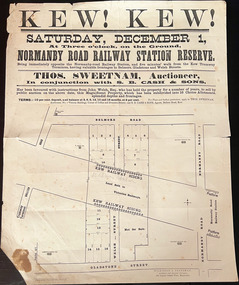
Plan, Kew! Kew!, 1888
... ...Land Subdivisions...The Land Boom of the 1880s accelerated the rate of subdivisions in Kew. This subdivision, 'Kew! ...subdivision are bisected by the route of the Outer Circle railway, and next to the proposed Normanby Station (later renamed East Kew). On the plan, local landmarks such as the tram terminus, the Harp of Erin hotel, and the station are located. The street where the lots are numbered , was called Welsh Street on the plan as this was the name of the vendor. Surrounding land...Outer Circle Railway Land Subdivisions Plan of an 1888 subdivision bounded by Bulleen Road (now High Street), Gladstone Street (now Campbell Street?) ...The Land Boom of the 1880s accelerated the rate of subdivisions in Kew. This subdivision, 'Kew! Kew!' was also impacted by, or resulted from, the decision by the Victorian Government to construct the Outer Circle railway. Construction of the railway began in 1888 and was completed in 1891. Plan of an 1888 subdivision bounded by Bulleen Road (now High Street), Gladstone Street (now Campbell Street?), Park Street (now Adeney Avenue), and Belmore Road (now Harp Road). The 16 lots in the proposed subdivision are bisected by the route of the Outer Circle railway, and next to the proposed Normanby Station (later renamed East Kew). On the plan, local landmarks such as the tram terminus, the Harp of Erin hotel, and the station are located. The street where the lots are numbered , was called Welsh Street on the plan as this was the name of the vendor. Surrounding land owners are also named: G. Smith Esq, Matthew Maher Esq, and Maurice Neligan Esq.outer circle railway, land subdivisions -
Canterbury History Group
Document - School Project: Elgar's Special Survey, Tudehope, Jennifer, 1963
... ...Land subdivisions...Maling> J Canterbury Road Survey Road Boroondara Roads Board Camberwell Historical Society Mont Albert Road Brooks> R. Land subdivisions Well researched essay on the background of Elgar's Special Survey. ...Well researched essay on the background of Elgar's Special Survey. Includes mapcanterbury, elgar> henry t., land surveys, boroondara, campbell> j & r, dacre> r, towns> r., sea> h., dyce> a., mccarthy> w.g., shenley> james, henty's paddock, norris> j.r., maling> j, canterbury road, survey road, boroondara roads board, camberwell historical society, mont albert road, brooks> r., land subdivisions -
Canterbury History Group
Document - Thematic Environmental History, Built Heritage, 1/05/2012
... ...Land subdivisions...Final document produced, after community consultation, for the City of Boroondara by Built Heritage City of Boroondara Canterbury Churches Cottages Dairies Danks Family Elgar Survey Exploration Frognall Goldings Boot Factory Maling Road Malone's Hotel Maps Masonic Lodges National Parks Native Plants Police Stations Post Offices Railways Rochester Road Schools Shrublands Soldiers Memorial Hall Sport Telephone Exchanges Theatres Transport Wildlife Canterbury Road Land subdivisions Parks and reserves Outer Circle railway Back yards 242 pages Document Thematic Environmental History Built Heritage ...Thematic Environmental Heritage. Final document produced, after community consultation, for the City of Boroondara by Built Heritage242 pages city of boroondara, canterbury, churches, cottages, dairies, danks family, elgar survey, exploration, frognall, goldings boot factory, maling road, malone's hotel, maps, masonic lodges, national parks, native plants, police stations, post offices, railways, rochester road, schools, shrublands, soldiers memorial hall, sport, telephone exchanges, theatres, transport, wildlife, canterbury road, land subdivisions, parks and reserves, outer circle railway, back yards