Showing 12383 items matching "land-clearing"
-
 Whitehorse Historical Society Inc.
Photograph, Land clearing, Mitcham, C1960's
... Land clearing, Mitcham...2 coloured photographs showing a bull dozer clearing land in Mitcham....Whitehorse Historical Society Inc. 2-10 Deep Creek Road Mitcham melbourne mitcham land clearing 2 coloured photographs showing a bull dozer clearing land in Mitcham. ...2 coloured photographs showing a bull dozer clearing land in Mitcham.mitcham, land clearing -
 Whitehorse Historical Society Inc.
Photograph - Black & white photograph, Clearing Land for Mitcham Reservoir
... Clearing Land for Mitcham Reservoir...Black and white photo of Teams of Horses clearing Land for M.M.B.W. Reservoir at Mitcham....Clearing Land for Mitcham Reservoir Photograph Black & white photograph ...Black and white photo of Teams of Horses clearing Land for M.M.B.W. Reservoir at Mitcham.meagher, ray, melbourne and metropolitan board of works, mitcham reservoir -
 National Vietnam Veterans Museum (NVVM)
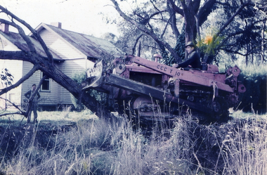
Document, Copy of a letter of thanks from the people of Tam Phucc (for clearing their land of mines) to Australian Army officers
... Copy of a letter of thanks from the people of Tam Phucc (for clearing their land of mines) to Australian Army officers...A copy of page 6 of a Letter of Thanks From The People of Tam Phuoc addressed to the Captaon Commanding, 17th Construction Squandron - Land Clearing Team and the Captain Commanding, 3 Cav Det attached to the Land Clearing Team for their assistance of helping their village to clear the land....National Vietnam Veterans Museum (NVVM) 25 Veterans Drive Newhaven phillip-island-and-the-bass-coast 17 Const Sqn Land Clearing Team 3 Cav Det Tam Phuoc Village Chief A copy of page 6 of a Letter of Thanks From The People of Tam Phuoc addressed to the Captaon Commanding, 17th Construction Squandron - Land Clearing Team and the Captain Commanding, 3 Cav Det attached to the Land Clearing Team for their assistance of helping their village to clear the land. ...A copy of page 6 of a Letter of Thanks From The People of Tam Phuoc addressed to the Captaon Commanding, 17th Construction Squandron - Land Clearing Team and the Captain Commanding, 3 Cav Det attached to the Land Clearing Team for their assistance of helping their village to clear the land.17 const sqn, land clearing team, 3 cav det, tam phuoc, village chief -
 National Vietnam Veterans Museum (NVVM)
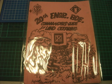
Booklet - Guide to land clearing, 20th Engineer Brigade guide to land clearing
... 20th Engineer Brigade guide to land clearing...Photocopied information book on land clearing. Ornate cover featuring tractors, trees & soldiers....Photocopied information book on land clearing. Ornate cover featuring tractors, trees & soldiers. 20th Engineer Brigade guide to land clearing Booklet Guide to land clearing ...11 paged booklet with pink cover. Photocopied information book on land clearing. Ornate cover featuring tractors, trees & soldiers.land clearing, engineers, 20th brigade -
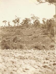
 Orbost & District Historical Society
black and white photograph, late 19th century - early 20th century
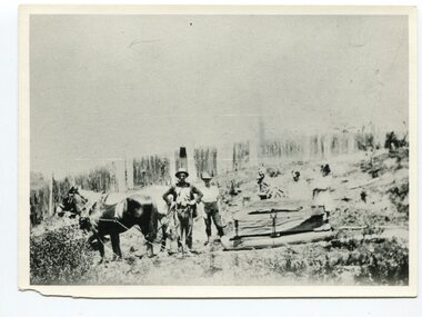
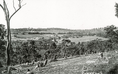
... This photograph shows land clearing at Bendoc. From 1845 the Bendoc area was part of pastoral leases. ...A badly distorted black / white photograph of a horse drawn wagon, three men and two women clearing land....on back - "Clearing land at Bendoc"...(info. from Victorian Places) This is a pictorial history associated with the early settlement of Bendoc in East Gippsland. bendoc-land-clearing bendoc-early-settlement on back - "Clearing land at Bendoc" A badly distorted black / white photograph of a horse drawn wagon, three men and two women clearing land. black and white photograph ...This photograph shows land clearing at Bendoc. From 1845 the Bendoc area was part of pastoral leases. In the 1850s alluvial gold was discovered in the Bendoc River. This was quickly exhausted, and a number of mines began successful reef operations. At the head of the river, the settlement of Clarkville clustered round several other mines. Many miners, including numbers of Chinese, sluiced the rivers. The population of the area was as high as 500 during this period. The township was surveyed in 1869 and the hotel built in 1870. This building was burnt down in the early 1900s and rebuilt. A school was also begun at this time. In the 1870s there was a decline in gold mining. Some miners selected land, which in many cases is still held by descendants. Dairying was common in the early days, supplying a butter factory at the New South Wales border, and a milk factory at Orbost in more recent times. Wheat was grown for the settlers' own use and ground at Bombala. Now beef cattle grazing is the main occupation. (info. from Victorian Places)This is a pictorial history associated with the early settlement of Bendoc in East Gippsland.A badly distorted black / white photograph of a horse drawn wagon, three men and two women clearing land.on back - "Clearing land at Bendoc"bendoc-land-clearing bendoc-early-settlement -
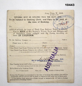 Bendigo Military Museum
Administrative record - TRAVEL VOUCHER, WW1, No. 2 Clearing Hospital AIF, 18 Jul 1919
... This voucher was issued by No.2 Clearing hospital but is blank in relation to who is receiving it....Stamped "AUSTRALIA" and stamped "No.2 GROUP CLEARING HOSPITAL"....No. 2 Clearing Hospital AIF...Administrative record TRAVEL VOUCHER, WW1 No. 2 Clearing Hospital AIF ...Vouchers issued to facilitate travel in UK for serving personnel. To apply, personnel needed to be in uniform. Part of the collection of William (Bill) Thomason. refer Cat no. 4136P.Small white form issued by soldier's unit that is a voucher authorisation for cheap travel on the railway service. This voucher was issued by No.2 Clearing hospital but is blank in relation to who is receiving it.Stamped and dated 19th July 1919. Stamped "AUSTRALIA" and stamped "No.2 GROUP CLEARING HOSPITAL".collection of william (bill) thomason, admin record, travel voucher', ww1 -
 Ringwood and District Historical Society
Photograph, Clearing at "Quambee", North Ringwood - 1912
... Clearing at "Quambee", North Ringwood - 1912....Sepia photograph showing land after partial clearing....Ringwood and District Historical Society 125A Warrandyte Road Ringwood North melbourne Sepia photograph showing land after partial clearing. Clearing at "Quambee", North Ringwood - 1912. ...Sepia photograph showing land after partial clearing. -
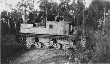 Upper Yarra Museum
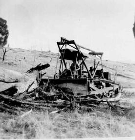
Negative Photographic Reproduction, George (Mick) Worlley’s Grant tank used for clearing scrub 1952 Hoddles Creek
... George (Mick) Worlley’s Grant tank used for clearing scrub 1952 Hoddles Creek...George Worlley bought a Grant Tank from Bandiana for clearing scrub and falling trees for the mill in 1952...George (Mick) Worlley’s Grant tank used for clearing scrub 1952 Hoddles Creek Black and White negative scanned at 600 dpi Check no ...Upper Yarra Museum Old Railway Station 2415C Warburton Highway Yarra Junction yarra-valley-and-dandenong-ranges George Worlley bought a Grant Tank from Bandiana for clearing scrub and falling trees for the mill in 1952 George (Mick) Worlley’s Grant tank used for clearing scrub 1952 Hoddles Creek Black and White negative scanned at 600 dpi Check no George (Mick) Worlley’s Grant tank used for clearing scrub 1952 Hoddles Creek Negative Photographic Reproduction Sandy Ross ...George Worlley bought a Grant Tank from Bandiana for clearing scrub and falling trees for the mill in 1952George (Mick) Worlley’s Grant tank used for clearing scrub 1952 Hoddles Creek Black and White negative scanned at 600 dpi Check no -
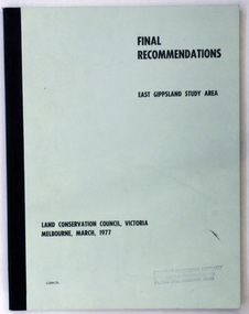 Orbost & District Historical Society
document, FINAL RECOMMENDATIONS E. GIPPSLAND STUDY AREA - LAND CONSERVATION COUNCIL, VICTORIA March 1977, March 1977
... GIPPSLAND STUDY AREA - LAND CONSERVATION COUNCIL, VICTORIA March 1977...Established in 1971, the Land Conservation Council operated under the Land Conservation Council Act 1970. ...A document of 75 pp with a pale green cover and black print, titled Final Recommendations East Gippsland Study area. Land Conservation Council, Melbourne, March, 1977....Land Conservation Council...Orbost & District Historical Society Ruskin Street Orbost gippsland Established in 1971, the Land Conservation Council operated under the Land Conservation Council Act 1970. ...Established in 1971, the Land Conservation Council operated under the Land Conservation Council Act 1970. In July 1997, the Environment Conservation Council Act 1997 came into operation. This Act revoked the Land Conservation Council Act 1970 and abolished the Land Conservation Council. An Environment Conservation Council was established in its place. (ref. TROVE) This document is a useful reference tool.A document of 75 pp with a pale green cover and black print, titled Final Recommendations East Gippsland Study area. Land Conservation Council, Melbourne, March, 1977.land-conservation-east-gippsland -
 Ringwood and District Historical Society
Land Sale Documents, Board of Land and Works, Documents pertaining to application for a land grant around Ringwood Lake in 1874, 30-May-1870 and 25-Mar-1874
... Documents pertaining to application for a land grant around Ringwood Lake in 1874....This concerns the application and granting of land to Anthony Ford around the Ringwood lake area in 1874. ...Documents pertaining to application for a land grant around Ringwood Lake in 1874. Copied documents, cream paper. 8pp. ...Board of Land and Works...+Additional Keywords: Ford, Anthony / Kennedy, James Documents pertaining to application for a land grant around Ringwood Lake in 1874. Land Sale Documents Board of Land and Works ...This concerns the application and granting of land to Anthony Ford around the Ringwood lake area in 1874. Includes details of improvements made to the area, including a dwelling. The land is described as being very poor and not worth the labour of cultivation. 8pp.Documents pertaining to application for a land grant around Ringwood Lake in 1874. Copied documents, cream paper. 8pp. +Additional Keywords: Ford, Anthony / Kennedy, James -
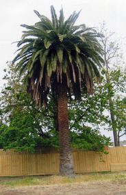 Whitehorse Historical Society Inc.
Photograph, Palm tree on original Schwerkolt Land, 1/10/2007 12:00:00 AM
... Palm tree on original Schwerkolt Land...Coloured photo taken in October 2007 of the palm tree planted by August Schwerkolt on land now owned by Council....Orchard Land of Complex...Whitehorse Historical Society Inc. 2-10 Deep Creek Road Mitcham melbourne schwerkolt palm trees Coloured photo taken in October 2007 of the palm tree planted by August Schwerkolt on land now owned by Council. Palm tree on original Schwerkolt Land Photograph Photograph ...Coloured photo taken in October 2007 of the palm tree planted by August Schwerkolt on land now owned by Council.schwerkolt, palm trees -
 Eltham District Historical Society Inc
Photograph, Clearing land for Le Pine Funeral Home, cnr York Street and Main Road, Eltham, c.March 1998, 1998
... Clearing land for Le Pine Funeral Home, cnr York Street and Main Road, Eltham, c.March 1998...Newsletter No. 116, September, 1997 846-848 MAIN ROAD ELTHAM Nillumbik Shire Council has granted a permit for a funeral parlour on land which includes this site at the corner of Main Road and York Street. ...If you have passed the site recently you will have noticed that it has now been demolished - another part of the old Eltham township has disappeared. a.r. warren eltham feed store le pine funeral home main road york street c.r. nicholls charles cockcroft grocery store Kodak Gold 200-6 Roll of 35mm colour negative film, 6 strips Also photographic prints 10 x 15 cm Clearing land for Le Pine Funeral Home, cnr York Street and Main Road, Eltham, c.March 1998 Photograph ...Newsletter No. 116, September, 1997 846-848 MAIN ROAD ELTHAM Nillumbik Shire Council has granted a permit for a funeral parlour on land which includes this site at the corner of Main Road and York Street. The site contains an architect's office in a building which was formerly a shop and dwelling dating from the 1920's. The proposal requires demolition of this building which is one of the few remaining old shops which formed the rather spread out "town centre" of Eltham. Prior to making its decision the Council obtained a report from Graeme Butler and Associates, the heritage consultants who carried out Stage 1 of the Nillumbik Heritage Study. The report summarized the historical significance as follows:- "This brick comer shop with associated residence has potential local historical significance as a late 1920's grocer's shop, now much altered and one of only a few shops of that era left in Eltham's Main Road. This significance is qualified by the many changes. The other examples are better preserved and still function as shops." With this type of expert advice it is difficult to make a strong case for preservation of the building although, of course, it is a shame to see it demolished. The report includes details of the site itself and its history based on research carried out by Carlotta Kellaway. The building dates from the late 1920's when it was owned by C.R. Nicholls. From the early 1930's it was Charles Cockroft's grocery shop and he also ran a grain store there. According to his daughter, Edna Brown, he delivered groceries around the district taking his truck as far as Kangaroo Ground. In 1950 he shifted to Traralgon. Since then several different businesses have operated from the site including a bottle merchant and produce store. Conversion to the present office use involved alterations to the shop front and rebuilding the galvanized iron store at the rear. Newsletter 119 March 1998 In our Newsletter No. 116 it was reported that the former shop on the comer of Main Road and York Street, Eltham was to be demolished as part of a funeral parlour development. If you have passed the site recently you will have noticed that it has now been demolished - another part of the old Eltham township has disappeared.Roll of 35mm colour negative film, 6 strips Also photographic prints 10 x 15 cmKodak Gold 200-6a.r. warren, eltham feed store, le pine funeral home, main road, york street, c.r. nicholls, charles cockcroft, grocery store -
University of Melbourne, Burnley Campus Archives
Journal - Journal Extract, Melbourne School of Land and Environment, Land & Environment, Summer 2013
... Land & Environment...Article in Land & Environment Summer 2013 p 13. "Burnley Gardens 150th."...Melbourne School of Land and Environment...Land & Environment Journal Journal Extract Melbourne School of Land and Environment ...150th celebrations, burnley gardens -
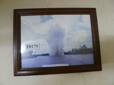 National Vietnam Veterans Museum (NVVM)
Photograph, Channel clearing operations Hoi An 1970
... Channel clearing operations Hoi An 1970...Colour photo of clearing operations...National Vietnam Veterans Museum (NVVM) 25 Veterans Drive Newhaven phillip-island-and-the-bass-coast Photograph Clearing operations Colour photo of clearing operations Channel clearing operations Hoi An 1970 Photograph Photograph ...Colour photo of clearing operationsphotograph, clearing operations -
Phillip Island and District Historical Society Inc.
Book, Korumburra &? District Historical Society, land of the lyre bird : a story of early settlement in the great forest of South Gippsland, being a description of the big scrub in its virgin state with its birds and animals, and of the adventures and hardships of its early explorers and prospectors, also accounts by the settlers of the clearing, settlement and development of the country, 1998
... land of the lyre bird : a story of early settlement in the great forest of South Gippsland, being a description of the big scrub in its virgin state with its birds and animals, and of the adventures and hardships of its early explorers and prospectors, also accounts by the settlers of the clearing, settlement and development of the country...Phillip Island and District Historical Society Inc. phillip-island-and-the-bass-coast land settlement victoria gippsland south gippsland personal observations history Stamped 'Phillip Island & District Historical Society'. land of the lyre bird : a story of early settlement in the great forest of South Gippsland, being a description of the big scrub in its virgin state with its birds and animals, and of the adventures and hardships of its early explorers and prospectors, also accounts by the settlers of the clearing, settlement and development of the country Book Korumburra &? ...Stamped 'Phillip Island & District Historical Society'.land settlement, victoria, gippsland, south gippsland, personal observations, history -
 Eltham District Historical Society Inc
Photograph, Tom Prior, Clearing land at Research
... Clearing land at Research...A second copy was also presented to the Andrew Ross Museum, Kangaroo Ground Black and white photograph mounted in an album, the Reynolds/Prior Photograph Collection, this being one of 53 reproduced black and white images of early Eltham. Clearing land at Research Photograph Tom Prior ...Main Road is in the distance with the aqueduct following the pine trees at top of photo. Doney's store is visible near the road.The Reynolds family were early settlers in Research. The Reynolds/ Prior collection of photographs were taken by Tom Prior, the maternal uncle of Ivy Reynolds, around 1900 and the 60 photos in the album give a fine overview of many of the landmarks of Research and Eltham over 100 years ago. lvy lived in the family home for many years at 106 Thompson Cres Research. Ivy's father, Ernst Richard Reynolds and grandfather, Richard Reynolds, lived at the same address. Ivy's father Richard worked for Mr. Trail on his property in Research. Reynolds Road is named after the family. Mr Tom Prior (wife Eva) worked at the Melbourne zoo. He was very innovative and made his own camera, using the black cloth hood to exclude the light. The photographs are a reminder of the rural nature of Research and Eltham and its rich heritage. Black and white photograph mounted in an album, the Reynolds/Prior Photograph Collection, this being one of 53 reproduced black and white images of early Eltham.The Reynolds/Prior Photograph Collection, Presented to the Eltham District Historical Society, 14 June 2006 by Ross McDonald. A second copy was also presented to the Andrew Ross Museum, Kangaroo Groundreynolds prior collection, research (vic.) -
National Vietnam Veterans Museum (NVVM)
Audio - Audio, CD, Photos from SVN 1971: land clearing and beast photos
... Photos from SVN 1971: land clearing and beast photos...National Vietnam Veterans Museum (NVVM) 25 Veterans Drive Newhaven phillip-island-and-the-bass-coast Vietnam War 1961 - 1975 - Land clearing Package contains hardcopies of photos and donation note from Brian Griffith Photos from SVN 1971: land clearing and beast photos Audio Audio, CD Griffith, Brian ...Package contains hardcopies of photos and donation note from Brian Griffithvietnam war, 1961 - 1975 - land clearing -
Lakes Entrance Historical Society
Book, Land Conservation Council Victoria, The Gippsland Lakes Land Use Strategy Plan 1978, 1985
... The Gippsland Lakes Land Use Strategy Plan 1978...A review of public land use in the East Gippsland area, including natural resources, flora and fauna, recreation. ...Land Conservation Council Victoria...The Gippsland Lakes Land Use Strategy Plan 1978 Book Land Conservation Council Victoria ...A review of public land use in the East Gippsland area, including natural resources, flora and fauna, recreation. Contains photographs, maps statistics.conservation, aboriginals, primary industry -
 Falls Creek Historical Society
Photograph - Old plough clearing trees
... Old plough clearing trees...Black and white photos of men clearing trees with a plough...These images record work being carried out to clear and maintain land in the Falls Creek area in 1953 bogong falls creek snow snowfields Black and white photos of men clearing trees with a plough Old plough clearing trees Photograph Old plough clearing trees ...This photo is part of the Fred Griffith Photographic Collection documenting his time with the Australian Alpine Club and the formation of the Albury Ski Club. Frederick Charles “Fred” Griffith was born in Albury, NSW on 2 March 1910. Educated in Albury and Geelong Grammar. Beginning in 1927 he spent many years working first as a jackeroo and on a range of prominent pastoral and merino stud properties in NSW and Queensland. In 1935 he repurchased his former family property “Toonallook", Bowna, NSW and developed it to be the largest Romney Marsh stud in the world, exporting rams to Argentina. He introduced many innovative practices on his property including rabbit control measures and aerial crop dusting. He was an active member of the Albury Show Society and in 1949 established the Albury Sheep Show. Fred was also the Albury representative on the Graziers’ Association Council for over 30 years. He became a life member of both the Albury and Commercial Clubs. Fred’s greatest hobby was snow skiing. His first visit to the snow was to Kosciusko in 1919. The Albury Ski Club was formed in 1935 and Fred was an inaugural member. In 1949 they were granted a site at Falls Creek to build their own lodge. Fred guaranteed the Club for finance from the Bank of NSW. The first portion of the prefabricated building was constructed in Albury. It was transported to Falls Creek on the back of Fred’s truck and erected in one day. This was the bathroom section and the rest was completed in 1950. The original lodge was burned down in 1952 and a new one built the following year. In 1955, Fred also built the Bowna Lodge for his family in partnership with David Fairbairn. He became head of the North Eastern District Skiing Association (N.E.D.S.A.) and successfully applied to run the Australian Ski Championships. Fred also inaugurated children’s races at Falls Creek and ran them for about 20 years. He also formed the company “Falls Creek Ski Tows”. In 1956 Fred along with a group of key people selected the site for Thredbo Village. Fred and his brother sold Toonallook in sections between 1951 and 1974. He moved to Albury and set up as a landscape gardener and fencing contractor. After a serious work accident, Fred retired in 1985 and moved to Rosebud, Victoria where he died on 19 August 1992.These images record work being carried out to clear and maintain land in the Falls Creek area in 1953Black and white photos of men clearing trees with a ploughbogong, falls creek, snow, snowfields -
Lakes Entrance Historical Society
Book, Land Conservation Council, Victoria, East Gippsland Area Review Final Recommendations Land Conservation, 1986
... East Gippsland Area Review Final Recommendations Land Conservation...History, climate, geomorphology, land use, flora and fauna are presented. Map included....Land Conservation Council, Victoria...East Gippsland Area Review Final Recommendations Land Conservation Book Land Conservation Council, Victoria ...Report describing the physical nature of the East Gippsland area (Victoria) study area. History, climate, geomorphology, land use, flora and fauna are presented. Map included.topography, land settlement -
 Merbein District Historical Society
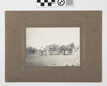
Photograph - Block clearing Merbein, Finnigans Photos Mildura, Clearing the block
... Clearing the block...Men helpers on the block when clearing M.S. Finnigans Mildura embossed card...Merbein District Historical Society 36 Box St Merbein the-murray horses blocks clearing timber Merbein Men helpers on the block when clearing M.S. ...Original sepia photograph mounted on cardboardMen helpers on the block when clearing M.S. Finnigans Mildura embossed cardhorses blocks clearing timber merbein -
 Phillip Island and District Historical Society Inc.
Book, Warwick Nelson & Martin Brabon, Scotland to the Island. And the call of the land, 2022
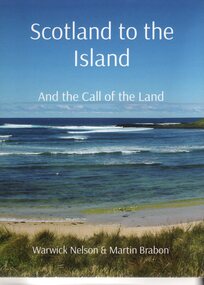
... And the call of the land....Robert Miller selected land in Ventnor in 1868. His daughter, Catherine, later lived nearby with the neighbouring bay named after her, Kitty Miller Bay....Book - Scotland to the Island and the call of the land. Large Book...Scotland to the Island. and the call of the land. Warwick Nelson & Martin Brabon...And the call of the land. Book Warwick Nelson & Martin Brabon ...The Miller family were one of the early settlers on Phillip Island. Robert Miller selected land in Ventnor in 1868. His daughter, Catherine, later lived nearby with the neighbouring bay named after her, Kitty Miller Bay.HistoricalBook - Scotland to the Island and the call of the land. Large BookScotland to the Island. and the call of the land. Warwick Nelson & Martin Brabonmiller family, kitty miller bay phillip island, catherine walker (nee kitty miller), warwick nelson, robert miller, farming, ventnor -
 Bendigo Military Museum
Photograph - RA Svy Project C4 Aerodist Operation, Eastern & Western Arnhem Land, NT, 1967, 1968
... RA Svy Project C4 Aerodist Operation, Eastern & Western Arnhem Land, NT...This is a set of 26 photographs of Royal Australian Survey Corps (RA Svy) personnel from Central Comd Fd Svy Unit (Adelaide) on Aerodist survey operation - Project C4 in Eastern Arnhem Land, Northern Territory in 1967 (photos .4P to .26P) and in Western Arnhem Land, Northern Territory in 1968 (photos .1P to .3P). ...This is a set of 26 photographs of Royal Australian Survey Corps (RA Svy) personnel on Aerodist survey operations in Eastern Arnhem Land, Northern Territory in 1967 and Western Arnhem Land, Northern Territory in 1968. ...Gove, Eastern Arnhem Land, NT...RA Svy Project C4 Aerodist Operation, Eastern & Western Arnhem Land, NT Photograph RA Svy Project C4 Aerodist Operation, Eastern & Western Arnhem Land, NT Army Survey Regiment ...This is a set of 26 photographs of Royal Australian Survey Corps (RA Svy) personnel from Central Comd Fd Svy Unit (Adelaide) on Aerodist survey operation - Project C4 in Eastern Arnhem Land, Northern Territory in 1967 (photos .4P to .26P) and in Western Arnhem Land, Northern Territory in 1968 (photos .1P to .3P). Photos of personnel were taken either at the operations base at Numbulwar or the main base at Gove (Nhulunbuy). RA Svy conducted nineteen Aerodist operations for 12 years from 1964 to 1975. Aerodist MRC2 was a tellurometer-based system adapted for aircraft to accurately measure distances between non-intervisible ground survey stations, using the aircraft as an intermediate station. Lower order geodetic results could be achieved by survey network trilateration. The measured distances between stations formed survey networks from which each station’s latitude and longitude was computed. Aerodist MRC2 was RA Svy’s major horizontal control survey tool for mainly medium scale topographic mapping (scale 1:100,000 Class A being spatially accurate to within 50 metres) in PNG, northern NT, north-west WA, Kalimantan Barat (West) Indonesia, Sumatra Indonesia, Gulf of Carpentaria and Cape York, QLD. In 1967, the Aerodist MRC2 Master equipment was installed in the aircraft featured in this set of photos, Executive Air Services’ (Essendon VIC) Grand Aero Commander VH-EXX. It was the same aircraft type and company contracted to Division of National Mapping for Aerodist MRC2 surveys. From July to October 1967 the aircraft was attached to Central Comd Fd Svy Unit (Adelaide - Major Don Ridge) on Project C4 eastern-Arnhem Land NT, where 317 Aerodist lines measuring 17,300 line miles were successfully completed. This was the most productive Aerodist project thus far. The most common helicopter used by RA Svy up to 1972 was the civilian Bell 47G-2 and the Sioux Light Observation Helicopters (LOH), the Australian Army’s equivalent featured in this photo set. These light observation helicopters had a limiting load carrying capacity of up to about 500 pounds. By comparison, one Aerodist team including two people weighed up to 1,500 pounds. In 1968, after completion of the Kimberley Aerodist Operation project, the Aerodist system in VH-EXX was immediately deployed to western-Arnhem Land NT for Central Comd Fd Svy Unit (Adelaide - Major Don Ridge) to complete the mapping control across northern NT from mid-July to October. The Aerodist MRC2 Remote antenna seen in Photos .24P to .26P is mounted on a 20 foot pole tower. The antenna direction was controlled by wires/ropes to the two arms under the dish at right angles. The antenna elevation could be changed to the vertical for aircraft height checks as seen in photo .25P. Source: Royal Australian Survey Corps – Aerodist Years 1964-1975 by Peter Jensen. Refer to Item 6449.30P for more photos taken during these Aerodist survey operations.This is a set of 26 photographs of Royal Australian Survey Corps (RA Svy) personnel on Aerodist survey operations in Eastern Arnhem Land, Northern Territory in 1967 and Western Arnhem Land, Northern Territory in 1968. The photographs are on 35mm negative film and scanned at 96 dpi. They are part of the Army Survey Regiment’s Collection. .1) to .2) – Photo, black & white, 1968, unidentified soldier with an opened can of food, possibly bully beef. .3) – Photo, black & white, 15 Aug 1968, aerial view of terrain taken from a helicopter in vicinity of MILINGIMBI SIERRA. .4) – Photo, black & white, 1967, aerial view of an island taken from a helicopter. .5) & .6) – Photo, black & white, 1967, unidentified soldier driving a Haflinger 4x4 Light utility vehicle with trailer. .7) – Photo, black & white, 1967, unidentified surveyors taking vertical measurements with a leveling instrument and staff. .8) – Photo, black & white, 1967, Australian Army Sioux Light Observation Helicopter (LOH) with float removed. .9) to .11) – Photo, black & white, 1967, Australian Army Sioux Light Observation Helicopter (LOH) with floats. .12) – Photo, black & white, 1967, civilian Bell 47G-2 helicopter (Australian Army Sioux LOH equivalent) refuelled. .13) – Photo, black & white, 1967, survey station on coastline surrounded by white plastic aerial photographic identification panels lined with rocks. .14) & .15) – Photo, black & white, 1967, soldier (possibly a signaller from RA Sigs) operating a radio. .16) – Photo, black & white, 1967, Central Comd Fd Svy Unit Operations Section tent, Main Base Gove (Nhulunbuy) L to R: SPR Harry Dunn, WO1 Pat Wood BEM. .17) – Photo, black & white, 1967, Central Comd Fd Svy Unit Operations Section tent, Main Base Gove (Nhulunbuy) L to R: unidentified, WO1 Pat Wood BEM. .18) – Photo, black & white, 1967, Central Comd Fd Svy Unit Operations Section, Main Base Gove (Nhulunbuy), unidentified Australian Army Catering Corps cook preparing meals. .19) – Photo, black & white, 1967, Central Comd Fd Svy Unit Operations Section, Main Base Gove (Nhulunbuy) mess tent in readiness for meals. .20) – Photo, black & white, 1967, Bank of batteries in transit boxes undergoing recharging using generators. .21) – Photo, black & white, 1967, A topographic survey identification plaque set in a concrete block being weighed using a set of scales hanging from slaughtering gallows. .22) – Photo, black & white, 1967, CPL (Geoff or Gary) Larkin operating the remote Aerodist MRC2 ground instrument at Veronica Island, located north of Nhulunbuy. .23) – Photo, black & white, 1967, L to R: CPL (Geoff or Gary) Larkin with unidentified surveyor operate the remote Aerodist MRC2 ground instrument at Venica Island, located north of Nhulunbuy. .24) & .25 – Photo, black & white, 1967, The Aerodist MRC2 Remote antenna. .26) – Photo, black & white, 1967, The Aerodist MRC2 Remote antenna.The following photos are annotated in black ink on edge of film negative: .3P – ’15 Aug ’68, 2000’, 1-C18 ’68 MILINGIMBI SIERRA’ .4P – ’U462’ .8P – ‘1-C3/67 Float Removed’ .13P – ‘U477 10-C3/67 .20P - ‘2-C3/67 Bank of Chargers’ .21P - ‘3-C3/67 Gallows & Scales’ .22P - ‘0462 VERONICA ISLAND NT, CPL Larkin’ .23P - ‘0462 VERONICA ISLAND NT’ .24P - ‘4-C3/67 20’ Aerodist Tower’ .25P - ‘5-C3/67 20’ Aerodist Tower’ .26P - ‘6-C3/67 20’ Aerodist Tower’royal australian survey corps, rasvy, army survey regiment, army svy regt, fortuna, asr, aerodist, surveying, central comd fd svy unit -
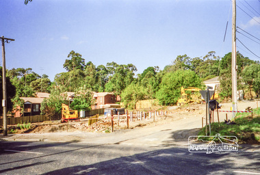
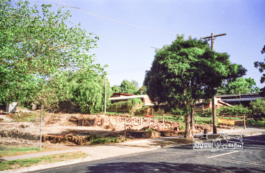
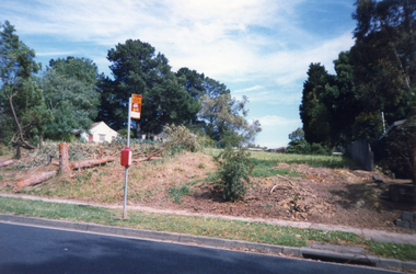 Whitehorse Historical Society Inc.
Photograph, Clearing Deep Creek Road, 2001
... Clearing Deep Creek Road...Coloured Photo of clearing for Bridge on Deep Creek Road, Mitcham, begins....Clearing Deep Creek Road Photograph Photograph ...Coloured Photo of clearing for Bridge on Deep Creek Road, Mitcham, begins.deep creek road, mitcham. -
Lakes Entrance Historical Society
Book, Land Conservation Council Victoria, Land Conservation Council East Gippsland Area Review, 1985
... Land Conservation Council East Gippsland Area Review...Report describing the physical and biological aspects of the public land in the eastern corner of Victoria, predominantly the Orbost Shire. ...Land Conservation Council Victoria...Many issues are covered in the report, including timber industry, national parks, waterways and tourism. Six maps Land Conservation Council East Gippsland Area Review Book Land Conservation Council Victoria ...Report describing the physical and biological aspects of the public land in the eastern corner of Victoria, predominantly the Orbost Shire. Many issues are covered in the report, including timber industry, national parks, waterways and tourism. Six mapsparks, waterways, tourism, gippsland -
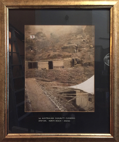 Tramways/East Melbourne RSL Sub Branch - RSL Victoria Listing id: 27511
Print, 1st Australian Casualty Clearing Station
... 1st Australian Casualty Clearing Station...Printed underneath the image is '1ST AUSTRALIAN CASUALTY CLEARING STATION, NORTH BEACH - ANZAC'...Images details terrain, building materials and overall conditions of the site. 1st Australian Casualty Clearing Station Print ...A framed print showing the temporary buildings set up on North Beach - Anzac Cove in WW1 to deal with incoming casualties. Images details terrain, building materials and overall conditions of the site. Printed underneath the image is '1ST AUSTRALIAN CASUALTY CLEARING STATION, NORTH BEACH - ANZAC'casualty clearing station, north beach, anzac, medical, triage, ww1, gallipoli -
 Lorne Historical Society
Photograph, Clearing Rockfall Great Ocean Road 1930's
... Clearing Rockfall Great Ocean Road 1930's...Photograph showing clearing of rockfall on the Great Ocean Road, circa 1930's...Lorne Historical Society Lorne Community House Mountjoy Parade Lorne great-ocean-road G.O.R:; Rockfall=-1930; Photograph showing clearing of rockfall on the Great Ocean Road, circa 1930's Clearing Rockfall Great Ocean Road 1930's Photograph Photograph ...Photograph showing clearing of rockfall on the Great Ocean Road, circa 1930'sg.o.r:; rockfall=-1930; -
University of Melbourne, Burnley Campus Archives
Magazine - Journal articles, Melbourne School of Land and Environment et al, Land & Environment, 2013
... Land & Environment...The Melbourne School of Land and Environment Magazine, Winter 2013. ...Melbourne School of Land and Environment...Welcome Back, Sugar by Megan Backhouse p 14. - Sugar Gum table and Chairs (originally appeared in The Age) Land & Environment Magazine Journal articles Melbourne School of Land and Environment Nerissa Hannink Megan Backhouse ...green roofs, sugar table