Showing 138 items matching "landowners"
-
 Kew Historical Society Inc
Archive (Sub-series) - Subject File, Early Landowners (Kew), 1958
... Early Landowners (Kew)...Small archive file that contains information on early landowners in Kew. The research and notes are unsigned and undated. ...John Murchison, Hugh Glass, Richard Davies Ireland, Edward Augustus Atkyns etc. Early Landowners (Kew) Archive Subject File ...Various partiesReference, Research, InformationSecondary Values (KHS Imposed Order)Small subject file that contains information on early landowners in Kew. The research and notes are unsigned and undated. There is also some research on residents named in the early rate books. Specific landowners with information about them in the file include notes by Mavis Rolley on J.W. Cowell and Catherine Cowell, George Wharton, Nicholas Fenwick, Capt. John Murchison, Hugh Glass, Richard Davies Ireland, Edward Augustus Atkyns etc.j.w. cowell, catherine cowell, john murchison, richard davies ireland, edward augustus atkyns, nicholas fenwick, george whartonj.w. cowell, catherine cowell, john murchison, richard davies ireland, edward augustus atkyns, nicholas fenwick, george wharton -
 Peterborough History Group
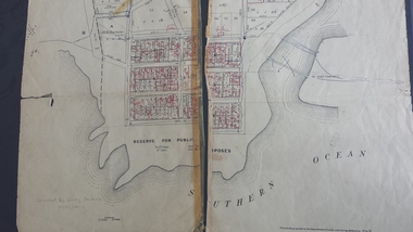
Map - Map of the town, Government Printer, Township of Peterborough
... 27/6/1931 paper map of the township of Peterborough including names of the landowners at that time....Handwritten landowner names over the original printed names....Significant as it shows the names of the owners of each allotment in 1931 and handwritten notes of more recent owners. peterborough old maps maps Handwritten landowner names over the original printed names. 27/6/1931 paper map of the township of Peterborough including names of the landowners at that time. ...Map donated by Barry Jenkins and assume that updated names were written on the map by him. Good information pertaining to the history of each allotment. Significant as it shows the names of the owners of each allotment in 1931 and handwritten notes of more recent owners.27/6/1931 paper map of the township of Peterborough including names of the landowners at that time.Handwritten landowner names over the original printed names.peterborough, old maps, maps -
Lakes Entrance Historical Society
Map - Merloch County of Tanjil
... landowners...Parish map landowners, roads....Lakes Entrance Historical Society 4 Marine Parade Lakes Entrance gippsland landowners Roads and Streets Parish map landowners, roads. ...Parish map landowners, roads.landowners, roads and streets -
 Beechworth Honey Archive
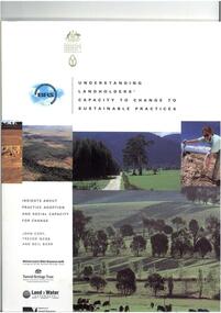
Publication, Understanding landowners' capacity to change to sustainable practices: insights about practice adoption and social capacity for change. (Cary, John, Webb, Trevor and Barr, Neil). Canberra, 2002, 2002
... Understanding landowners' capacity to change to sustainable practices: insights about practice adoption and social capacity for change. ...Beechworth Honey Archive 87 Ford Street Beechworth high-country 67 pages Understanding landowners' capacity to change to sustainable practices: insights about practice adoption and social capacity for change. ...67 pages -
Lakes Entrance Historical Society
Map - Township of Raymond Island/Parish of Bairnsdale/County of Tanjil 1964, AC Brooks Government Printer, 1964
... landowners...Shows McMillan Strait, Lake Victoria, Landowners names...landowners Waterways Shows McMillan Strait, Lake Victoria, Landowners names Map Township of Raymond Island/Parish of Bairnsdale/County of Tanjil 1964 AC Brooks Government Printer ...Shows McMillan Strait, Lake Victoria, Landowners nameslandowners, waterways -
Lakes Entrance Historical Society
Map - Gelantipy
... Landowners...Shows landowners Gelantipy, Peeck, Westphal, Reidy, Butchers Creek...Landowners Waterways Rh of Marroo Shows landowners Gelantipy, Peeck, Westphal, Reidy, Butchers Creek Map Gelantipy ...Shows landowners Gelantipy, Peeck, Westphal, Reidy, Butchers CreekRh of Marroolandowners, waterways -
Lakes Entrance Historical Society
Map - Benworden County of Tanjil
... Landowners...Parish map landowners, Backwater Morass, Lake Victoria...Lakes Entrance Historical Society 4 Marine Parade Lakes Entrance gippsland East Gippsland Historical Society Inc. B 1928 Landowners Waterways Township Parish map landowners, Backwater Morass, Lake Victoria Map Benworden County of Tanjil ...East Gippsland Historical Society Inc. B 1928Parish map landowners, Backwater Morass, Lake Victorialandowners, waterways, township -
Lakes Entrance Historical Society
Map - Colquhoun
... ...landowners...Map of Colquhoun showing landowners Lake Tyers and Lakes Entrance...Lakes Entrance Historical Society 4 Marine Parade Lakes Entrance gippsland Maps Townships landowners Map of Colquhoun showing landowners Lake Tyers and Lakes Entrance Map Colquhoun ...Map of Colquhoun showing landowners Lake Tyers and Lakes Entrancemaps, townships, landowners -
Lakes Entrance Historical Society
Map - Purgagoolah County of Croajingolong, Department of Lands and Survey
... Landowners...Shows landowners Glen Arte River, Crabhole Creek, Bemm River, Cabbage Creek River...Landowners Waterways Shows landowners Glen Arte River, Crabhole Creek, Bemm River, Cabbage Creek River Map Purgagoolah County of Croajingolong Department of Lands and Survey A C Brooks Govv. ...Shows landowners Glen Arte River, Crabhole Creek, Bemm River, Cabbage Creek Riverlandowners, waterways -
Lakes Entrance Historical Society
Map - Township of Manorina Parish of Jilwain County of Croajingolong, Department of Lands and Survey, 1967
... Landowners...Shows allotments some with landowners, Princes Highway, Main Road Shire of Orbost...Landowners Roads and Streets Township Shows allotments some with landowners, Princes Highway, Main Road Shire of Orbost Map Township of Manorina Parish of Jilwain County of Croajingolong Department of Lands and Survey ...Shows allotments some with landowners, Princes Highway, Main Road Shire of Orbostlandowners, roads and streets, township -
Lakes Entrance Historical Society
Map - Township of Bendoc Parish of Bendock County of Croajingolong, Department of Lands and Survey, 1951
... ...Landowners...Shows Bendock River, Landowners, Land occupied by Snowy Mountains Hydro Electric Authority...Waterways Landowners Hydro Electricity Shows Bendock River, Landowners, Land occupied by Snowy Mountains Hydro Electric Authority Map Township of Bendoc Parish of Bendock County of Croajingolong Department of Lands and Survey ...Shows Bendock River, Landowners, Land occupied by Snowy Mountains Hydro Electric Authoritywaterways, landowners, hydro electricity -
Lakes Entrance Historical Society
Map - Meerlieu County of Tanjil
... Landowners...Shows Parish map, landowners, Lake Wellington, Toms Creek, Princes Highway, Providence Ponds....Lakes Entrance Historical Society 4 Marine Parade Lakes Entrance gippsland East Gippsland Historical Society Inc. No B1937 Landowners Waterways Roads Shows Parish map, landowners, Lake Wellington, Toms Creek, Princes Highway, Providence Ponds. ...East Gippsland Historical Society Inc. No B1937Shows Parish map, landowners, Lake Wellington, Toms Creek, Princes Highway, Providence Ponds.landowners, waterways, roads -
Lakes Entrance Historical Society
Map - Tonghi County of Croajingolong, Department of Lands and Survey, 24/8/1926
... ...Landowners...Shows landowners Tonghi Creek, Cann River, Serpentine Creek, Reedy Creek, State Forests...Waterways Landowners Forest Shows landowners Tonghi Creek, Cann River, Serpentine Creek, Reedy Creek, State Forests Map Tonghi County of Croajingolong Department of Lands and Survey ...Shows landowners Tonghi Creek, Cann River, Serpentine Creek, Reedy Creek, State Forestswaterways, landowners, forest -
Lakes Entrance Historical Society
Map - Nungurner Township
... Landowners...Shows landowners - Bates, Bury, Riches, Peart, Bell, Dolphin, Kempton, Reeves Channel, Bumberah...Landowners Township Waterways Shows landowners - Bates, Bury, Riches, Peart, Bell, Dolphin, Kempton, Reeves Channel, Bumberah Map Nungurner Township ...Shows landowners - Bates, Bury, Riches, Peart, Bell, Dolphin, Kempton, Reeves Channel, Bumberahlandowners, township, waterways -
Lakes Entrance Historical Society
Map - Bullumwaal c1900, 1985
... ...landowners...Township map shows landowners, roads, Boggy Creek, mines....Lakes Entrance Historical Society 4 Marine Parade Lakes Entrance gippsland Based on the first survey of the township map drawn on from memory by Syd Hibbins Roads and Streets Mines and Mining Townships Waterways landowners Township map shows landowners, roads, Boggy Creek, mines. ...Based on the first survey of the township map drawn on from memory by Syd HibbinsTownship map shows landowners, roads, Boggy Creek, mines.roads and streets, mines and mining, townships, waterways, landowners -
Lakes Entrance Historical Society
Map - Figure 2.3 Lakes Entrance Commercial Strategy-Shire of Tambo Strategy Plan, Tract Consultants Pty Ltd Landscape Architects and Urban Planners
... ...Landowners...Shows roads and landowners, Bulloch Island, Cunninghame Arm, Ninety Mile Beach...Islands Waterways Roads Landowners Shows roads and landowners, Bulloch Island, Cunninghame Arm, Ninety Mile Beach Map Figure 2.3 Lakes Entrance Commercial Strategy-Shire of Tambo Strategy Plan Tract Consultants Pty Ltd Landscape Architects and Urban Planners ...Shows roads and landowners, Bulloch Island, Cunninghame Arm, Ninety Mile Beachislands, waterways, roads, landowners -
Lakes Entrance Historical Society
Map - Bumberrah Counties of Dargo and Tambo
... ...landowners...Shows landowners, state forest, Colquhoun North and Tambo River, Tambo Bay and Nicholson River....Lakes Entrance Historical Society 4 Marine Parade Lakes Entrance gippsland Waterways Forest Township landowners Shows landowners, state forest, Colquhoun North and Tambo River, Tambo Bay and Nicholson River. ...Shows landowners, state forest, Colquhoun North and Tambo River, Tambo Bay and Nicholson River.waterways, forest, township, landowners -
Lakes Entrance Historical Society
Map - Glenaladale County of Tanjil, Dept of Lands and Survey
... ...landowners...Shows landowners, roads, Mitchell River, Woolshed Creek, Cobbannan Creek. ...Lakes Entrance Historical Society 4 Marine Parade Lakes Entrance gippsland Waterways Roads and Streets landowners Township Shows landowners, roads, Mitchell River, Woolshed Creek, Cobbannan Creek. ...Shows landowners, roads, Mitchell River, Woolshed Creek, Cobbannan Creek. Insert map of township of Iguanawaterways, roads and streets, landowners, township -
Lakes Entrance Historical Society
Map - Bumberrah Counties of Dargo and Tambo. Colquhoun Counties of Tambo and Tanjil, Dept of Lands and Survey, 1918
... Landowners...Two maps joined together showing landowners, forests, Bass Strait, Lake King, Tambo Bluff....Landowners Waterways Forest Shoreline Two maps joined together showing landowners, forests, Bass Strait, Lake King, Tambo Bluff. ...Two maps joined together showing landowners, forests, Bass Strait, Lake King, Tambo Bluff.landowners, waterways, forest, shoreline -
Lakes Entrance Historical Society
Map - Tabbara County of Croajingolong
... ...Landowners...Shows Orbost East, Cabbage Tree Creek, Marlo, Princes Highway, Bass Strait, Landowners, Aerodrome Reserve...Townships Settlement Aerodromes Landowners Shows Orbost East, Cabbage Tree Creek, Marlo, Princes Highway, Bass Strait, Landowners, Aerodrome Reserve Map Tabbara County of Croajingolong ...Shows Orbost East, Cabbage Tree Creek, Marlo, Princes Highway, Bass Strait, Landowners, Aerodrome Reservetownships, settlement, aerodromes, landowners -
Lakes Entrance Historical Society
Map - Bidwell County of Croajingolong, Department of Lands and Survey, 18/1/1932
... Landowners...Shows landowners Bendoc River, unnamed roads, timber reserve,Errinundra, Bendock, Dellicknora, Bonang, Cabanandra....Landowners Waterways Roads Forestry Townships Shows landowners Bendoc River, unnamed roads, timber reserve,Errinundra, Bendock, Dellicknora, Bonang, Cabanandra. ...Shows landowners Bendoc River, unnamed roads, timber reserve,Errinundra, Bendock, Dellicknora, Bonang, Cabanandra.landowners, waterways, roads, forestry, townships -
Lakes Entrance Historical Society
Map - Boole Poole County of Tanjil, Dept of Lands and Survey, 1965
... landowners...Shows landowners named on Boole Poole. The Lakes National Park, Sperm Whale Head, Lake Victoria, Seacombe. 2 pages A and B and four photocopies....Lakes Entrance Historical Society 4 Marine Parade Lakes Entrance gippsland landowners Waterways Parks Land settlement Shows landowners named on Boole Poole. ...Shows landowners named on Boole Poole. The Lakes National Park, Sperm Whale Head, Lake Victoria, Seacombe. 2 pages A and B and four photocopies.landowners, waterways, parks, land settlement -
Lakes Entrance Historical Society
Map - Lakes Entrance Waterways
... ...Landowners...Shows Fraser Island, Bullock Island, Snake Island, Hopetown Channel, Lakes Entrance, Landowners R H McMahon, A Sanford, H Keating, J A Carpenter...Islands Waterways Township Landowners Shows Fraser Island, Bullock Island, Snake Island, Hopetown Channel, Lakes Entrance, Landowners R H McMahon, A Sanford, H Keating, J A Carpenter Map Lakes Entrance Waterways ...Shows Fraser Island, Bullock Island, Snake Island, Hopetown Channel, Lakes Entrance, Landowners R H McMahon, A Sanford, H Keating, J A Carpenterislands, waterways, township, landowners -
Lakes Entrance Historical Society
Map - Colquhoun County of Tambo, Department of Lands and Survey, 28/12/1988
... ...Landowners...Shows Reeves River, original entrance to lakes near Lake Bunga, Landowners, Lakes Entrance and Lake Tyers Beach area, Aboriginal Reserve Lake Tyers 2 pages A and B...Townships Waterways Aboriginal reserve Landowners Shows Reeves River, original entrance to lakes near Lake Bunga, Landowners, Lakes Entrance and Lake Tyers Beach area, Aboriginal Reserve Lake Tyers 2 pages A and B Map Colquhoun County of Tambo Department of Lands and Survey T Gowan ...Shows Reeves River, original entrance to lakes near Lake Bunga, Landowners, Lakes Entrance and Lake Tyers Beach area, Aboriginal Reserve Lake Tyers 2 pages A and Btownships, waterways, aboriginal reserve, landowners -
Lakes Entrance Historical Society
Map - Colquhoun Area Bruthen District, roads and landowners
... Shows roads and landowners...Forest Land Settlement Shows roads and landowners Map Colquhoun Area Bruthen District, roads and landowners ...Shows roads and landownersforest, land settlement -
Lakes Entrance Historical Society
Map - Colquhoun Counties of Tambo and Tanjil
... Map showing original landowners of Colquhoun Counties...Lakes Entrance Historical Society 4 Marine Parade Lakes Entrance gippsland Land Settlement Records Map showing original landowners of Colquhoun Counties Map Colquhoun Counties of Tambo and Tanjil ...Map showing original landowners of Colquhoun Countiesland settlement, records -
Eltham District Historical Society Inc
Folder, Fleming, 1851
... Folder of information on Fleming, Landowner, Diamond Creek, 1851...Eltham District Historical Society Inc 728 Main Rd Eltham melbourne Fleming Folder of information on Fleming, Landowner, Diamond Creek, 1851 Fleming Folder ...Folder of information on Fleming, Landowner, Diamond Creek, 1851fleming -
Whitehorse Historical Society Inc.
Legal record - Land Title, Spall Orchard, 1916-1982
... Principal landowners: Louis Schwerkolt (Vol.3955 Fol.825), Francis Arnold Vaughan and James George & Sybil Margaret Spall (Vol.8249 Fol. 849). ...Certificates of Title relating to the Spall Orchard, Wattle Valley Road Mitcham and surrounding parts of Crown Portion 128, Parish of Nunawading. Principal landowners: Louis Schwerkolt (Vol.3955 Fol.825), Francis Arnold Vaughan and James George & Sybil Margaret Spall (Vol.8249 Fol. 849). ...Whitehorse Historical Society Inc. 2-10 Deep Creek Road Mitcham melbourne Principal landowners: Louis Schwerkolt (Vol.3955 Fol.825), Francis Arnold Vaughan and James George & Sybil Margaret Spall (Vol.8249 Fol. 849). ...Certificates of Title relating to the Spall Orchard, Wattle Valley Road Mitcham and surrounding parts of Crown Portion 128, Parish of Nunawading.Certificates of Title relating to the Spall Orchard, Wattle Valley Road Mitcham and surrounding parts of Crown Portion 128, Parish of Nunawading. Principal landowners: Louis Schwerkolt (Vol.3955 Fol.825), Francis Arnold Vaughan and James George & Sybil Margaret Spall (Vol.8249 Fol. 849). With historical summary, agent's sale notice 1984 and letter from Shirley Mill.Certificates of Title relating to the Spall Orchard, Wattle Valley Road Mitcham and surrounding parts of Crown Portion 128, Parish of Nunawading.wattle valley road, mitcham, highland avenue mitcham, trenham court mitcham, spall, james george, spall, sybil margaret, vaughan, francis arnold, schwerkolt, louis, mill, shirley, land titles -
 Peterborough History Group
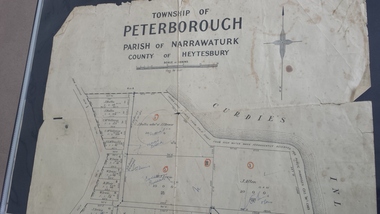
Map - Map of the township of Peterborough, Township of Peterborough
... Includes the names of the landowners 1931...Includes the names of the landowners 1931 Township of Peterborough Map Map of the township of Peterborough ...Same map as 4012 but printed names are easier to read. Hand drawn arrows show the road now built connecting Macs St to the Warrnambool RdShows early layout of the town and names of landownersgovernment map of the township of Peterborough with handwritten notes on it. Includes the names of the landowners 1931some hand drawn arrows.peterborough, old maps, maps -
 Kew Historical Society Inc
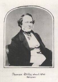
Photograph - Photograph [copy], Thomas Wills about 1856, 56 years, 1856
... Wills was an early landowner in Kew....Wills was an early landowner in Kew. Thomas Wills about 1856, 56 years Photograph Photograph [copy] ...Wills Street in the Kew ward of Studley Park was named after Thomas Wills. This work forms part of the collection assembled by the historian Dorothy Rogers, that was donated to the Kew Historical Society by her son John Rogers in 2015. The manuscripts, photographs, maps, and documents were sourced by her from both family and local collections or produced as references for her print publications. Many were directly used by Rogers in writing ‘Lovely Old Homes of Kew’ (1961) and 'A History of Kew' (1973), or the numerous articles on local history that she produced for suburban newspapers. Most of the photographs in the collection include detailed annotations in her hand.The Rogers Collection provides a comprehensive insight into the working habits of a historian in the 1960s and 1970s. Together it forms the largest privately-donated collection within the archives of the Kew Historical SocietyA copy of a portrait of Thomas Wills, aged 56 years. Wills was an early landowner in Kew.Thomas Wills - Born Sydney 1799. Built Willsmere Farm ca. 1850thomas wills, kew, dorothy rogers, wills street, wills family