Showing 1402 items matching "lands"
-
 Stawell Historical Society Inc
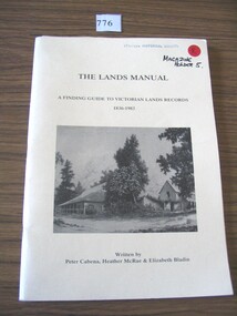
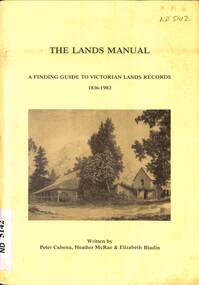
Book, Peter Cabena, Heather McRae & ElizabethBladin, The Lands Manual - A Finding guide to Victorias Lands Records 1836-1983, 1989
... The Lands Manual - A Finding guide to Victorias Lands Records 1836-1983...The Purpose of this manual is to describe the documentary archives of the Department of Crown Lands and Survey (Lands Department) and Explain, how they can be used for historical research...The Lands Manual A Finding guide to Victorian Lands Records 1836-1983 Written by Peter Cabena, Heather McRae & Elizabeth Baldin...Stawell Historical Society Inc 46 Longfield St Stawell grampians The Purpose of this manual is to describe the documentary archives of the Department of Crown Lands and Survey (Lands Department) and Explain, how they can be used for historical research stawell The Lands Manual A Finding guide to Victorian Lands Records 1836-1983 Written by Peter Cabena, Heather McRae & Elizabeth Baldin Yellow card Cover Black Print and B/W Photo of two wooden buildings The Lands Manual - A Finding guide to Victorias Lands Records 1836-1983 Book Peter Cabena, Heather McRae & ElizabethBladin Alliance Printing Company Pty, Ltd ...The Purpose of this manual is to describe the documentary archives of the Department of Crown Lands and Survey (Lands Department) and Explain, how they can be used for historical researchYellow card Cover Black Print and B/W Photo of two wooden buildings The Lands Manual A Finding guide to Victorian Lands Records 1836-1983 Written by Peter Cabena, Heather McRae & Elizabeth Baldinstawell -
 Ballan Shire Historical Society
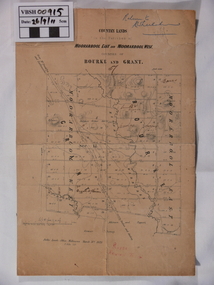
Map - Map. Moorarbool East and West, Country Lands in the Parishes of Moorarbool East and Moorarbool West. Counties of Bourke and Grant
... Country Lands in the Parishes of Moorarbool East and Moorarbool West. ...This is a map of "Country Lands" around the Werribee River, north of Ballan in the Counties of Bourke and Grant....Public Lands Office...Moorarbool East and West. Public Lands Office ...This is a map of "Country Lands" around the Werribee River, north of Ballan in the Counties of Bourke and Grant.A relatively small map, paper on a material backing. Shows topographical features, roads and property divisions. Scale of forty chains to one inch. The map is dated March 31st, 1859.There is a small inscription under the chain scale that reads "No 58/364 John Phillips ? Survey 1st August 1858". The name Dugald McPherson is hand written on one of the blocks of land.moorarbool west, moorarbool east, dugald mcpherson, county of bourke, county of grant, werribee river, ballan -
 Marysville & District Historical Society
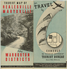
Map (Item) - Tourist Map, Department of Lands & Survey, Tourist Map of Healesville, Marysville and Warburton Districts, 1938
... A tourist map for Healesville, Marysville and Warburton that was produced by the Victorian Department of Crown Lands and Survey, in conjunction with Victorian Railways, in 1938....A tourist map for Healesville, Marysville and Warburton that was produced by the Victorian Department of Crown Lands and Survey, in conjunction with Victorian Railways, in 1938....Compiled by the Department of Lands and Survey, Melbourne Issued by the Betterment and Publicity Board, Victorian Railways, Melbourne, Victoria. ...Department of Lands & Survey...A tourist map for Healesville, Marysville and Warburton that was produced by the Victorian Department of Crown Lands and Survey, in conjunction with Victorian Railways, in 1938. healesville marysville warburton victoria tourist information tourism map tourist map victorian deparment of crown lands and survey victorian railways betterment and publicity board Compiled by the Department of Lands and Survey, Melbourne Issued by the Betterment and Publicity Board, Victorian Railways, Melbourne, Victoria. ...A tourist map for Healesville, Marysville and Warburton that was produced by the Victorian Department of Crown Lands and Survey, in conjunction with Victorian Railways, in 1938.A tourist map for Healesville, Marysville and Warburton that was produced by the Victorian Department of Crown Lands and Survey, in conjunction with Victorian Railways, in 1938.Compiled by the Department of Lands and Survey, Melbourne Issued by the Betterment and Publicity Board, Victorian Railways, Melbourne, Victoria. May 1938healesville, marysville, warburton, victoria, tourist information, tourism, map, tourist map, victorian deparment of crown lands and survey, victorian railways, betterment and publicity board -
 Bendigo Military Museum
Journal - Desert Exploration - Extract from Northern Territory Lands and Survey Dept Annual Report 1960-61, Northern Territory Lands and Survey Branch, 1961
... Desert Exploration - Extract from Northern Territory Lands and Survey Dept Annual Report 1960-61...This Extract from Northern Territory Lands and Survey Dept Annual Report 1960-61 is about Desert Exploration between Wave Hill and Tennant Creek. ...Northern Territory Lands and Survey Branch...Pages and maps are two hole punched Desert Exploration - Extract from Northern Territory Lands and Survey Dept Annual Report 1960-61 Journal Desert Exploration - Extract from Northern Territory Lands and Survey Dept Annual Report 1960-61 Northern Territory Lands and Survey Branch ...This Extract from Northern Territory Lands and Survey Dept Annual Report 1960-61 is about Desert Exploration between Wave Hill and Tennant Creek. The 2 x fold out maps are 1:1,000,000 scale with one showing a Levelling Traverse. The exploration took place during March and April 1960. This document has been included in the RASvy collection because it was valuable information that was needed by RASvy surveyors who were required to operate in the area in later years.5 x foolscap sized pages and 2 x map foldout pages held together with a slide clip. Pages and maps are two hole punchedroyal australian survey corps, rasvy, fortuna, army survey regiment, army svy regt, asr -
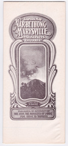
 Marysville & District Historical Society
Map (Item) - Tourist Map, Department of Lands & Survey, Tourist's Map of Narbethong and Marysville Districts Victoria, 1913
... A tourist map for the Narbethong and Marysville Districts that was originally produced by the Department of Lands & Survey in 1925....A tourist map for the Narbethong and Marysville Districts that was originally produced by the Department of Lands & Survey in 1925....Photo Lithographed at the Department of Lands and Survey Melbourne by W.J. Butson/ 26.8.13...Department of Lands & Survey...Marysville & District Historical Society 39 Darwin Street Marysville yarra-valley-and-the-dandenong-ranges A tourist map for the Narbethong and Marysville Districts that was originally produced by the Department of Lands & Survey in 1925. A tourist map for the Narbethong and Marysville Districts that was originally produced by the Department of Lands & Survey in 1925. narbethong marysville victoria department of lands & survey the acheron valley warburton map tourist map Reprint of the 1925 Tourist brochure by permission R.E. ...A tourist map for the Narbethong and Marysville Districts that was originally produced by the Department of Lands & Survey in 1925.A tourist map for the Narbethong and Marysville Districts that was originally produced by the Department of Lands & Survey in 1925.Reprint of the 1925 Tourist brochure by permission R.E. Holmes Surveyor General By Authority: ALBERT J. MULLETT, Government Printer, Melbourne. Photo Lithographed at the Department of Lands and Survey Melbourne by W.J. Butson/ 26.8.13narbethong, marysville, victoria, department of lands & survey, the acheron valley, warburton, map, tourist map -
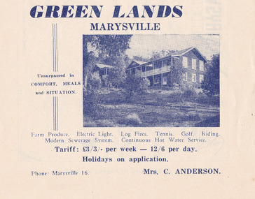 Marysville & District Historical Society
Ephemera (Item) - Advertisement, GREEN LANDS MARYSVILLE, Unknown
... GREEN LANDS MARYSVILLE...An advertisement for Green Lands guest house in Marysville....An advertisement for Green Lands guest house in Marysville....GREEN LANDS MARYSVILLE Ephemera Advertisement ...An advertisement for Green Lands guest house in Marysville.An advertisement for Green Lands guest house in Marysville.marysville, victoria, australia, greenlands, the spot, green lanes, sarah mclean, murdock mclean, geoffrey cobb, cath m anderson, mr and mrs a.g. clarke, e pigdon, bert patterson, guest house, advertisement -
![Map, Public Lands Office, Township of Sandridge [cartographic material] / lithographed at the Public Lands Office, March 30th 1859, 30 March 1859](/media/collectors/4f729f5897f83e0308601603/items/63c6354eae7bf372478c58b7/item-media/63c635d4ae7bf372478c7627/item-fit-380x285.jpg?cb=6) Mission to Seafarers Victoria
Mission to Seafarers VictoriaMap, Public Lands Office, Township of Sandridge [cartographic material] / lithographed at the Public Lands Office, March 30th 1859, 30 March 1859
... Township of Sandridge [cartographic material] / lithographed at the Public Lands Office, March 30th 1859....Public Lands Office...It also shows the name Gregory, a family of land owners who became the managers of the new building on the same site in 1889. sandridge bethel church customs house gregory Township of Sandridge [cartographic material] / lithographed at the Public Lands Office, March 30th 1859. Map Public Lands Office ...The map shows where the land of the Customs House was and where the Bethel church was built in 1860. It also shows the name Gregory, a family of land owners who became the managers of the new building on the same site in 1889.sandridge, bethel church, customs house, gregory -
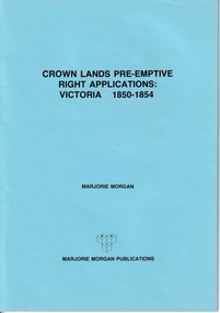 Whitehorse Historical Society Inc.
Administrative record - Crown Land Valuations and Applications, Government Printer - John FERRES, Crown Lands Pre-emptive Right Applications: Victoria 1850-1854, 1855
... Crown Lands Pre-emptive Right Applications: Victoria 1850-1854...This document contains the return of all lands alienated from the Crown (in Victoria) and applied for under Pre-Emptive right with the name of Purchaser, etc on 20 April 1855....Contains a valuation for Crown Lands applications under pre-emptive right by Victorian county, giving names of applicants name of run, area, and remarks. ...Contains a valuation for Crown Lands applications under pre-emptive right by Victorian county, giving names of applicants name of run, area, and remarks. ...Contains a valuation for Crown Lands applications under pre-emptive right by Victorian county, giving names of applicants name of run, area, and remarks.Contains a valuation for Crown Lands applications under pre-emptive right by Victorian county, giving names of applicants name of run, area, and remarks. Contains a valuation for Crown Lands applications under pre-emptive right by Victorian county, giving names of applicants name of run, area, and remarks. clarke andrew, anglesey, evelyn, bourke, dalhousie, dundas, follett, grant, hampden, heytesbury, normanby, polwarth, ripon, talbot, villiers, district of murray, district of wimmera, district of western port, early settlement, mornington -
 Tatura Irrigation & Wartime Camps Museum
Book, Register of Lands, 1984
... Register of Lands...Register of Lands in Tatura district regarding annual water rights for farms 1983-84...Black lettering, SR & WSC Victoria, Register of Lands, Rodney Irrigation area of Goulburn Murray Irrigation District. 1983-84 Irrigation Season...Black lettering, SR & WSC Victoria, Register of Lands, Rodney Irrigation area of Goulburn Murray Irrigation District. 1983-84 Irrigation Season Register of Lands Book ...Register of Lands in Tatura district regarding annual water rights for farms 1983-84Grey back cover, pale green front cover, blue cloth spine. Black lettering, SR & WSC Victoria, Register of Lands, Rodney Irrigation area of Goulburn Murray Irrigation District. 1983-84 Irrigation Seasonfarming, irrigation, books, rural, industry -
 Linton and District Historical Society Inc
Letter, Paper manufactured by T. Edmonds 1890 (watermark), Department of Lands and Survey, Argyle Common, Linton, 1897, 18.05.1897
... Department of Lands and Survey, Argyle Common, Linton, 1897...MacGibbon, Secretary for Lands, to C. Stratton, Secretary, Argyle Common, Linton. ...Handwritten letter on grey paper headed Department of Lands and Survey, dated 18th May 1897. Addressee C. ...MacGibbon, Secretary for Lands, to C. Stratton, Secretary, Argyle Common, Linton. ...Letter written on behalf of Tho. MacGibbon, Secretary for Lands, to C. Stratton, Secretary, Argyle Common, Linton. Acknowledging receipt of Argyle Common accounts for 1896, and informing of their passing by the Board of Land and Parks. Also requesting that in future the accounts should be prepared on the prescribed form, a copy of which was enclosed. Found in the home of Miss Margaret Gorman after her death. See form sent with letter - Registration No. 1617Handwritten letter on grey paper headed Department of Lands and Survey, dated 18th May 1897. Addressee C. Stratton Esq.-Secretary-Argyle Common-Linton.argyle common linton, animal grazing, agricultural activity, chris stratton -
 Whitehorse Historical Society Inc.
Manual - Government (Lands Dept), Royal Historical Society of Victoria, The Lands Manual - A Finding Guide to Victorian Land Records 1836 - 1983, March 1989
... The Lands Manual - A Finding Guide to Victorian Land Records 1836 - 1983...The manual documents the archives of the Department of Crown Lands and Survey (Lands Department) and explains how they can be used for historical research....Whitehorse Historical Society Inc. 2-10 Deep Creek Road Mitcham melbourne As the Department existed for nearly 130 years, it created a vast collection of maps, plans, correspondence files, business registers, letter, books and other ancillary records. Crown Lands Victoria. Department of Crown Lands and Survey The manual documents the archives of the Department of Crown Lands and Survey (Lands Department) between 1836 to 1983 and explains how they can be used for historical research. ...The manual documents the archives of the Department of Crown Lands and Survey (Lands Department) between 1836 to 1983 and explains how they can be used for historical research.The manual documents the archives of the Department of Crown Lands and Survey (Lands Department) and explains how they can be used for historical research.The manual documents the archives of the Department of Crown Lands and Survey (Lands Department) between 1836 to 1983 and explains how they can be used for historical research.crown lands, victoria. department of crown lands and survey -
RMIT GSBL Justice Smith Collection
Report, Australian Law Reform Commission, Lands acquisition and compensation : report no. 14, 1980
... Lands acquisition and compensation : report no. 14 ...Lands Acquisition and Compensation Report No. 14 ...RMIT GSBL Justice Smith Collection Building 13 379-405 Russell Street Melbourne melbourne government purchasing of real property -- australia compensation (law) -- australia eminent domain -- australia ISBN: 0642034281 Lands Acquisition and Compensation Report No. 14 Lands acquisition and compensation : report no. 14 Report Australian Law Reform Commission Australian Government Publishing Service ...Lands Acquisition and Compensation Report No. 14 ISBN: 0642034281 government purchasing of real property -- australia, compensation (law) -- australia, eminent domain -- australia -
Stawell Historical Society Inc
Map, Locality Plan, Shewing Lands for Sale, 1866
... Locality Plan, Shewing Lands for Sale ...Locality Plan, Shewing Lands for Sale ...Stawell Historical Society Inc 46 Longfield St Stawell grampians Stawell Locality Plan, Shewing Lands for Sale Locality Plan, Shewing Lands for Sale Map ...Locality Plan, Shewing Lands for Sale stawell -
Stawell Historical Society Inc
Map, Country Lands Parishes of Drung Drung & Golton Golton, 1866
... Country Lands Parishes of Drung Drung & Golton Golton ...Country Lands Parishes of Drung Drung & Golton Golton ...Stawell Historical Society Inc 46 Longfield St Stawell grampians Stawell Country Lands Parishes of Drung Drung & Golton Golton Country Lands Parishes of Drung Drung & Golton Golton Map ...Country Lands Parishes of Drung Drung & Golton Golton stawell -
Federation University Historical Collection
Document, Crown Lands Act, 1862, 1862
... Crown Lands Act, 1862...Blue foolscap printed Government document on the Crown Lands Act. ...Barker Library (top floor) Mount Helen goldfields land land sales crown land ararat petition Blue foolscap printed Government document on the Crown Lands Act. Crown Lands Act, 1862 Document John Ferres John Ferres ...Blue foolscap printed Government document on the Crown Lands Act. land, land sales, crown land, ararat, petition -
Federation University Historical Collection
Document, Crown Lands Alienated , 1861, 1861
... Crown Lands Alienated , 1861...Blue Foolscap printed Government document relating to alienated Crown Lands. ...Barker Library (top floor) Mount Helen goldfields crown lands Blue Foolscap printed Government document relating to alienated Crown Lands. ...Blue Foolscap printed Government document relating to alienated Crown Lands. crown lands -
 Rutherglen Historical Society
Document - License to thin trees, 1899 (Exact)
... "Department of Lands and Survey. On Forest Business"...Secretary for Lands, Department of Lands and Survey / On Forest Business...On back, copy of Land Act Regulations 1890 Document License to thin trees Secretary for Lands, Department of Lands and Survey / On Forest Business ...Dated July 14th 1899. Sent to Mr W. Cooper / c/o Mr Barrie / Storekeeper / No. 2 Valley / Chiltern / "Copy of Land Act 1896 / Regulations. Chapter XI Thinning Licenses"Document on stiff paper. Letter to Mr W. Cooper granting license to thin trees on a block of land at Chiltern Reserve. On back, copy of Land Act Regulations 1890"Department of Lands and Survey. On Forest Business"license, timber felling, cooper family, forestry, chiltern reserve -
Whitehorse Historical Society Inc.
Document, Will of Francisco Schwerkolt and statement of lands, 1945
... Will of Francisco Schwerkolt and statement of lands...Will of Francisco Schwerkolt, 1945 and inventory of assets plus statement of lands comprised in assessment, 1946....Whitehorse Historical Society Inc. 2-10 Deep Creek Road Mitcham melbourne Schwerkolt Family Schwerkolt Francesca Will of Francisco Schwerkolt, 1945 and inventory of assets plus statement of lands comprised in assessment, 1946. Will of Francisco Schwerkolt and statement of lands Document Document ...Will of Francisco Schwerkolt, 1945 and inventory of assets plus statement of lands comprised in assessment, 1946.schwerkolt family, schwerkolt, francesca -
 Ringwood and District Historical Society
Archive, Lands Department Field Notes, Ringwood 1878-1955 (Parent Record)
... Lands Department Field Notes, Ringwood 1878-1955 (Parent Record)...This record is the Parent Record for contents of folder "Lands Department - Survey of Field Notes of Ringwood Area"....Lands Department Field Notes, Ringwood 1878-1955 (Parent Record) Archive ...This record is the Parent Record for contents of folder "Lands Department - Survey of Field Notes of Ringwood Area". -
Whitehorse Historical Society Inc.
Document, Department of Crown Lands and Survey, 1983
... Department of Crown Lands and Survey...Research guide of historical resources of the Department of Crown Lands and Survey. Compiled by P. Cabena, Aug 1983...Cabena, Aug 1983 Department of Crown Lands and Survey Document Document ...Research guide of historical resources of the Department of Crown Lands and Survey. Compiled by P. Cabena, Aug 1983Research guide of historical resources of the Department of Crown Lands and Survey. Compiled by P. Cabena, Aug 1983Research guide of historical resources of the Department of Crown Lands and Survey. Compiled by P. Cabena, Aug 1983crown land, land surveys, victorian government -
 Bacchus Marsh & District Historical Society
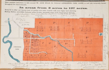
Map, Lerderderg Park Lands sale plan. 1911
... Lerderderg Park Lands sale plan. 1911....The plan has been extensively annotated with hand-written notes indicating the names of people who purchased the various parcels of lands and the prices paid for those lands. ...Top: Have received instructions to Sell, account Mr John Wills, his renowned LERDERDERG PARK LANDS, so well and favourably known throughout the Commonwealth. ...The plan has been extensively annotated with hand-written notes indicating the names of people who purchased the various parcels of lands and the prices paid for those lands. ...This plan was for the sale of parcels of land from the Lerderderg Park Estate property in 1911. Advertising for the sale appeared in the Bacchus Marsh Express newspaper through July of 1911. The property was situated only a few kilometers from the township of Bacchus Marsh. The agents for the sale were L. A. Fairbairn & Co.Lerderderg Park Estate was a significant and early colonial property in the Bacchus Marsh area. This plan provides details about the first time the property was subdivided for sale. It is therefore documents an important moment in the history of this property and the broader trend of the subdivision of older and larger properties in the district.A single page paper plan showing allotments of land for sale from the Lerderderg Park property owned by John Wills. The parcels of land for sale are coloured in red.The Lerderderg River and Pyke's Creek Irigation Channel shown on the plan are in blue ink. The rest of the plan is a dark cream or beige colur with the text in black ink. The plan has been extensively annotated with hand-written notes indicating the names of people who purchased the various parcels of lands and the prices paid for those lands. Part of the top of the plan containing some text appears to be missing. The plan is pasted into a bound volume containing 76 maps or plans in total. Top: Have received instructions to Sell, account Mr John Wills, his renowned LERDERDERG PARK LANDS, so well and favourably known throughout the Commonwealth. In areas from 3 acres to 1276 acres. Every lot is either rich lucerne land (or portion now under lucerne) with some higher land adjoining Railway Station, and 2 Milk factories within 2 miles, absolutely the finest land in Victoria. Bottom: THIS IS THE FIRST SUBDIVISIONAL SALE of Rich Flats in Bacchus Marsh since the Pyke's Creek Scheme, and every lot is commanded by it. Only 32 miles from Melbourne.bacchus marsh victoria maps, land sales, lerderderg park estate, land subdivision -
Port Melbourne Historical & Preservation Society
Map - Port Melbourne, Department of Lands and Survey, 20 Sep 1932
... Dept. of Lands and Survey Map Sheet 5 Port Melbourne, Parish of South Melbourne....Department of Lands and Survey...Department of Lands and Survey...Map Port Melbourne Department of Lands and Survey Department of Lands and Survey ...Dept. of Lands and Survey Map Sheet 5 Port Melbourne, Parish of South Melbourne.Annotated re MHT precincts on foreshore:Plan sketches re boat harbourtown planning, sandridge lagoon, melbourne harbor trust - port of melbourne authority, transport - railways -
Tatura Irrigation & Wartime Camps Museum
Book, Register of Lands, 1966-67
... Register of Lands...Red linen card covered book. 3 brass screws holding pages. Register of Lands written on cover....Tatura Irrigation & Wartime Camps Museum 49 Hogan Street Tatura the-murray Register setting out Water Rights apportioned and Rating Divisions 1966-67 season for Goulburn Murray Irrigation District irrigation rating divisions water rights apportioned books accounts rural industry Red linen card covered book. 3 brass screws holding pages. Register of Lands written on cover. Register of Lands Book ...Register setting out Water Rights apportioned and Rating Divisions 1966-67 season for Goulburn Murray Irrigation DistrictRed linen card covered book. 3 brass screws holding pages. Register of Lands written on cover.irrigation, rating divisions, water rights apportioned, books, accounts, rural, industry -
Lakes Entrance Historical Society
Book, Andrew Claridge, Survey of Crown Lands 1989, 1989
... Survey of Crown Lands 1989...A Preliminary Survey of Crown Lands between Lake Bunga and Mill Piont, Lake Tyers Beach Area Victoria....Survey of Crown Lands 1989 Book Andrew Claridge ...A Preliminary Survey of Crown Lands between Lake Bunga and Mill Piont, Lake Tyers Beach Area Victoria.surveying -
 Federation University Historical Collection
Document, Victorian Crown Lands Bill Petition, 1856-7, 1857
... Victorian Crown Lands Bill Petition, 1856-7...Blue Foolscap printed document relating to a Crown Lands Bill Petition ordered by the Legislative Assembly to be printed on 21 August 1857....Victorian Crown Lands Bill Petition, 1856-7 Document John Ferres ...Blue Foolscap printed document relating to a Crown Lands Bill Petition ordered by the Legislative Assembly to be printed on 21 August 1857.crown land, petition, emerald hill, robert anderson, james eville -
 St Kilda Historical Society
Photograph - Photo map, Department of Crown Lands and Survey (1857-1983), 22/01/1970
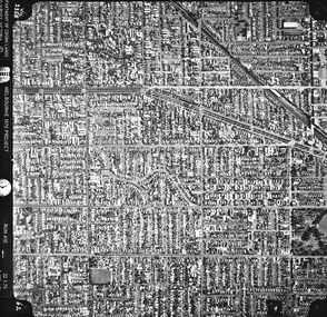
... One of a series of photo-maps produced for the Department of Crown Lands and Survey (1857-1983). For correlation with a current map, and access to other historical photo maps of Victoria, see the Historic Photo-Maps Index published by the Department of Environment, Land, Water and Planning at https://services.land.vic.gov.au/DELWPmaps/historical-photomaps/...Vic 2358 Department of Crown Lands and Survey Victoria,.© Melbourne 1970 Project Run 41E 22.1.70 5,100 ASL 62...Department of Crown Lands and Survey (1857-1983)...St Kilda Historical Society St Kilda Branch Library 150 Carlisle Street St Kilda melbourne One of a series of photo-maps produced for the Department of Crown Lands and Survey (1857-1983). For correlation with a current map, and access to other historical photo maps of Victoria, see the Historic Photo-Maps Index published by the Department of Environment, Land, Water and Planning at https://services.land.vic.gov.au/DELWPmaps/historical-photomaps/ Caulfield Caulfield North St Kilda EAst Armadale 1970 Vic 2358 Department of Crown Lands and Survey Victoria,.© Melbourne 1970 Project Run 41E 22.1.70 5,100 ASL 62 Black and white aerial photograph Photograph Photo map Department of Crown Lands and Survey (1857-1983) ...One of a series of photo-maps produced for the Department of Crown Lands and Survey (1857-1983). For correlation with a current map, and access to other historical photo maps of Victoria, see the Historic Photo-Maps Index published by the Department of Environment, Land, Water and Planning at https://services.land.vic.gov.au/DELWPmaps/historical-photomaps/Black and white aerial photographVic 2358 Department of Crown Lands and Survey Victoria,.© Melbourne 1970 Project Run 41E 22.1.70 5,100 ASL 62caulfield, caulfield north, st kilda east, armadale, 1970 -
 St Kilda Historical Society
Photograph - Photo map, Department of Crown Lands and Survey (1857-1983), 22/01/1970
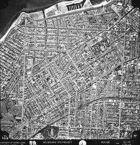
... One of a series of photo-maps produced for the Department of Crown Lands and Survey (1857-1983). For correlation with a current map, and access to other historical photo maps of Victoria, see the Historic Photo-Maps Index published by the Department of Environment, Land, Water and Planning at https://services.land.vic.gov.au/DELWPmaps/historical-photomaps/...Vic 2358 Department of Crown Lands and Survey Victoria,.© Melbourne 1970 Project Run 42E 22.1.70 5,100 ASL 77...Department of Crown Lands and Survey (1857-1983)...St Kilda Historical Society St Kilda Branch Library 150 Carlisle Street St Kilda melbourne One of a series of photo-maps produced for the Department of Crown Lands and Survey (1857-1983). For correlation with a current map, and access to other historical photo maps of Victoria, see the Historic Photo-Maps Index published by the Department of Environment, Land, Water and Planning at https://services.land.vic.gov.au/DELWPmaps/historical-photomaps/ St Kilda St Kilda East St Kilda Marina Elwood Elwood canal Elsternwick Park Point Ormond Balaclava MC Moran Reserve Ripponlea St Kilda Botanical Gardens Peanut farm 1970 Vic 2358 Department of Crown Lands and Survey Victoria,.© Melbourne 1970 Project Run 42E 22.1.70 5,100 ASL 77 Black and white aerial photograph Photograph Photo map Department of Crown Lands and Survey (1857-1983) ...One of a series of photo-maps produced for the Department of Crown Lands and Survey (1857-1983). For correlation with a current map, and access to other historical photo maps of Victoria, see the Historic Photo-Maps Index published by the Department of Environment, Land, Water and Planning at https://services.land.vic.gov.au/DELWPmaps/historical-photomaps/Black and white aerial photographVic 2358 Department of Crown Lands and Survey Victoria,.© Melbourne 1970 Project Run 42E 22.1.70 5,100 ASL 77st kilda, st kilda east, st kilda marina, elwood, elwood canal, elsternwick park, point ormond, balaclava, mc moran reserve, ripponlea, st kilda botanical gardens, peanut farm, 1970 -
 St Kilda Historical Society
Photograph - Photo map, Department of Crown Lands and Survey, 22/01/1970
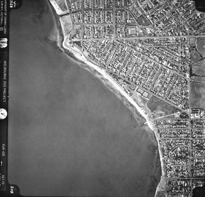
... One of a series of photo-maps produced for the Department of Crown Lands and Survey (1857-1983). For correlation with a current map, and access to other historical photo maps of Victoria, see the Historic Photo-Maps Index published by the Department of Environment, Land, Water and Planning at https://services.land.vic.gov.au/DELWPmaps/historical-photomaps/...Vic 2358 Department of Crown Lands and Survey Victoria,.© Melbourne 1970 Project Run 43E 22.1.70 5,100 ASL 208...Department of Crown Lands and Survey ...St Kilda Historical Society St Kilda Branch Library 150 Carlisle Street St Kilda melbourne One of a series of photo-maps produced for the Department of Crown Lands and Survey (1857-1983). For correlation with a current map, and access to other historical photo maps of Victoria, see the Historic Photo-Maps Index published by the Department of Environment, Land, Water and Planning at https://services.land.vic.gov.au/DELWPmaps/historical-photomaps/ Elwood Elwood beach Point Ormond Elwood Park Elwood canal MC Moran Reserve 1970 Vic 2358 Department of Crown Lands and Survey Victoria,.© Melbourne 1970 Project Run 43E 22.1.70 5,100 ASL 208 Black and white aerial photograph Photograph Photo map Department of Crown Lands and Survey ...One of a series of photo-maps produced for the Department of Crown Lands and Survey (1857-1983). For correlation with a current map, and access to other historical photo maps of Victoria, see the Historic Photo-Maps Index published by the Department of Environment, Land, Water and Planning at https://services.land.vic.gov.au/DELWPmaps/historical-photomaps/Black and white aerial photographVic 2358 Department of Crown Lands and Survey Victoria,.© Melbourne 1970 Project Run 43E 22.1.70 5,100 ASL 208elwood, elwood beach, point ormond, elwood park, elwood canal, mc moran reserve, 1970 -
 St Kilda Historical Society
Photograph - Photo map, Department of Crown Lands and Survey, 22/01/1970
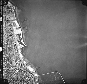
... One of a series of photo-maps produced for the Department of Crown Lands and Survey (1857-1983). For correlation with a current map, and access to other historical photo maps of Victoria, see the Historic Photo-Maps Index published by the Department of Environment, Land, Water and Planning at https://services.land.vic.gov.au/DELWPmaps/historical-photomaps/...Vic 2358 Department of Crown Lands and Survey Victoria,.© Melbourne 1970 Project Run 42E 22.1.70 5,100 ASL 75...Department of Crown Lands and Survey ...St Kilda Historical Society St Kilda Branch Library 150 Carlisle Street St Kilda melbourne One of a series of photo-maps produced for the Department of Crown Lands and Survey (1857-1983). For correlation with a current map, and access to other historical photo maps of Victoria, see the Historic Photo-Maps Index published by the Department of Environment, Land, Water and Planning at https://services.land.vic.gov.au/DELWPmaps/historical-photomaps/ St Kilda St Kilda beach St Kilda marina Point Ormond St Kilda pier 1970 Vic 2358 Department of Crown Lands and Survey Victoria,.© Melbourne 1970 Project Run 42E 22.1.70 5,100 ASL 75 Black and white aerial photograph Photograph Photo map Department of Crown Lands and Survey ...One of a series of photo-maps produced for the Department of Crown Lands and Survey (1857-1983). For correlation with a current map, and access to other historical photo maps of Victoria, see the Historic Photo-Maps Index published by the Department of Environment, Land, Water and Planning at https://services.land.vic.gov.au/DELWPmaps/historical-photomaps/Black and white aerial photographVic 2358 Department of Crown Lands and Survey Victoria,.© Melbourne 1970 Project Run 42E 22.1.70 5,100 ASL 75st kilda, st kilda beach, st kilda marina, point ormond, st kilda pier, 1970