Showing 21 items matching "lava flow"
-
 Hume City Civic Collection
Photograph, early 1990's
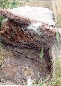
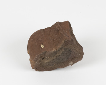
... A soil profile showing a whitened lava flow above decomposing timber and soil at the lower level....The photographs were included in a study of these sites which was published by the Shire of Bulla in the early 1990's. aboriginal ring sites george evans collection A soil profile showing a whitened lava flow above decomposing timber and soil at the lower level. ...The set of 20 photographs were taken of a number of archaeological sites in Sunbury of sacred sites and aboriginal rings. The photographs were included in a study of these sites which was published by the Shire of Bulla in the early 1990's.A soil profile showing a whitened lava flow above decomposing timber and soil at the lower level.aboriginal ring sites, george evans collection -
 Federation University Historical Collection
Booklet, Thomas Stephen Hart, The Highlands and Main Divide of Western Victoria, 1907, 12/12/1907
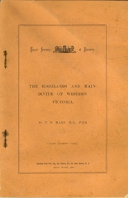
... ...lava flow...Hart was a teacher at the Ballarat School of Mines, and a member of the Ballarat Field Naturalists Club thomas hart thomas s. hart ballarat school of mines ballarat field naturalists club royal society of victoria western victoria ballarat great dividing range mt william volcano volcanic plains waterways lal lal basin yarrowee creek ballarat common lava flow wendouree warrenheip ballarat plateau mt elephant grampians t.s. hart mt buangor mt beckworth mt misery mt bolton lal lal iron ored mt ararat mt wiliam mt cole burrumbeet mt warrenheip daylesford waubra ercildoun gap smythesdale lal lal falls parwan valley burrumbeet creek staffordshire reef pyranees bacchus marsh rowsley fault ben nevis avoca hill landsborough hill mt blowhard weatherboard mclean's hill Fyan's Creek thomas stephen hart lal lal Article with illustrations published by the Royal Society of Victoria by Thomas S. ...Thomas S. Hart was a teacher at the Ballarat School of Mines, and a member of the Ballarat Field Naturalists ClubArticle with illustrations published by the Royal Society of Victoria by Thomas S. Hart. The following plates are included: Fig 1. The Main Divide and some of the transverse ridges Fig 2. Hills on and near the Divide at the Ercildoun and Ascot Gaps Fig. 3. Profile of the Divide at Ascot Gap. Fig. 4. Sketch of the Hills west and north-west from Mt Buninyong - - The divide in Ascot Gap from Mt Blowhard (Serra Range, Mt William, Mt Ararat, Larne Gerin, Ben Major, Mt Cole, Mt Misery, Mt Bolton) Fig. 5. Diagram to illustrate the possible courses of the leads south of the present Divide - Burrumbeet Basin (Smythesdale, Ballarat, Lal Lal , Mt Doran, egerton, Parwan Creet, Rowsley Fault, Eastern Plateau) Fig. 6. Diagramatic cross section of the grampians, south of Hall's Gap. Profile of the Pyranees, from maiden Hill - Diagramatic Section of the Grampians south of Hall's Gap. (Mt Cole, Mt Mitchell, Ben Major, Ben More, Avoca Hill, Hall's Gap.) Fig. 7. Profile of the Pyrenees as seen from Maiden Hill near Waubra.thomas hart, thomas s. hart, ballarat school of mines, ballarat field naturalists club, royal society of victoria, western victoria, ballarat, great dividing range, mt william, volcano, volcanic plains, waterways, lal lal basin, yarrowee creek, ballarat common, lava flow, wendouree, warrenheip, ballarat plateau, mt elephant, grampians, t.s. hart, mt buangor, mt beckworth, mt misery, mt bolton, lal lal iron ored, mt ararat, mt wiliam, mt cole, burrumbeet, mt warrenheip, daylesford, waubra, ercildoun gap, smythesdale, lal lal falls, parwan valley, burrumbeet creek, staffordshire reef, pyranees, bacchus marsh, rowsley fault, ben nevis, avoca hill, landsborough hill, mt blowhard, weatherboard, mclean's hill, fyan's creek, thomas stephen hart, lal lal -
 Ballarat Heritage Services
Photograph - Colour Photograph, Clare Gervasoni, Mount Greenock, 2025, 28/06/2025
... In the crater are blocks and bombs of scoriaceous basalt. Long lava flows extend both north and south from the cone. ...In the crater are blocks and bombs of scoriaceous basalt. Long lava flows extend both north and south from the cone. ...Mt Greenock is an extinct volcano with lava flows associated with a deep lead. It is a tall scoria cone with a broad shallow crater open to the northwest. In the crater are blocks and bombs of scoriaceous basalt. Long lava flows extend both north and south from the cone. It is considered a significant geological site, and part of the Major Mitchell Trail, with a 1936 ‘Centenary of Major Mitchell ‘monument on the summit. The flow to the north has been eroded by McCallum Creek which is a lateral stream. On the eastern base of the cone, the stream valley exposes a lava flow and underlying sedimentary rocks. The lava flow and the scoria cone overlie the Greenock lead (a buried valley with auriferous gravels). A line of mine tailing and abandoned mining relics associated with the former Union Mine occur on the margins of the lava flow. Mount Greenock is a 120 hectare ‘Geological Reserve’, is one of the few large scoria cones on public land and contains abundant outcrop and morphological evidence of its volcanic origin. Colour Photographs of Mt Greenock, near Talbot, Victoria. The photographs were taken in winter not long after the first post drought rains. Mt Greenock was climbed by Major Thomas Mitchell on 26 September 1936, and he gave it the current name. At that time the mount was part of Alexander McCallum's Dunach Forest Pastoral Run.mt greenock, mount greenock, mining, mullock heap, mt greenock geological reserve, union mine, volcanic grasslands, dunach -
 Ballarat Heritage Services
Photograph - Colour Photograph, Clare Gervasoni, Built Remains near Mount Greenock, 2025, 28/06/2025
... In the crater are blocks and bombs of scoriaceous basalt. Long lava flows extend both north and south from the cone. ...In the crater are blocks and bombs of scoriaceous basalt. Long lava flows extend both north and south from the cone. ...Mt Greenock is an extinct volcano with lava flows associated with a deep lead. It is a tall scoria cone with a broad shallow crater open to the northwest. In the crater are blocks and bombs of scoriaceous basalt. Long lava flows extend both north and south from the cone. It is considered a significant geological site, and part of the Major Mitchell Trail, with a 1936 ‘Centenary of Major Mitchell ‘monument on the summit. The flow to the north has been eroded by McCallum Creek which is a lateral stream. On the eastern base of the cone, the stream valley exposes a lava flow and underlying sedimentary rocks. The lava flow and the scoria cone overlie the Greenock lead (a buried valley with auriferous gravels). A line of mine tailing and abandoned mining relics associated with the former Union Mine occur on the margins of the lava flow. Mount Greenock is a 120 hectare ‘Geological Reserve’, is one of the few large scoria cones on public land and contains abundant outcrop and morphological evidence of its volcanic origin. Colour Photographs of bluestone and brick buildings at Mt Greenock, near Talbot, Victoria. The photographs were taken in winter not long after the first post drought rains. mt greenock, mount greenock, mining, mullock heap, mt greenock geological reserve, union mine, volcanic grasslands, dunach -
 Ballarat Heritage Services
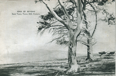
Photograph - Image - Black and White, Gum Trees on Tower Hill, Victoria, c1950, c1950
... Tower hill is a dormant volcano, with associated conical hills, large and small craters, basalt outcrops from lava flows and layers of Ash from long ago eruptions. ...Tower hill is a dormant volcano, with associated conical hills, large and small craters, basalt outcrops from lava flows and layers of Ash from long ago eruptions. gum trees tower hill A black and white image of two trees in a barron landscape at tower Hill,Victoria Gum Trees on Tower Hill, Victoria, c1950 Photograph Image - Black and White ...Tower Hill is 18km west of Warrnambool and is accessed from the Princes Highway. Tower hill is a dormant volcano, with associated conical hills, large and small craters, basalt outcrops from lava flows and layers of Ash from long ago eruptions. A black and white image of two trees in a barron landscape at tower Hill,Victoriagum trees, tower hill -
 Ballarat Heritage Services
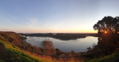
Photograph, Clare Gervasoni, Tower Hill Crater, 11/09/2020
... Tower hill is a dormant volcano, with associated conical hills, large and small craters, basalt outcrops from lava flows and layers of Ash from long ago eruptions. ...Tower hill is a dormant volcano, with associated conical hills, large and small craters, basalt outcrops from lava flows and layers of Ash from long ago eruptions. ...Tower Hill is 18km west of Warrnambool and is accessed from the Princes Highway. Tower hill is a dormant volcano, with associated conical hills, large and small craters, basalt outcrops from lava flows and layers of Ash from long ago eruptions. Panorama of the crater at Tower Hilltower hill, crater, volcano -
 Ballarat Heritage Services
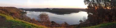
Photograph, Clare Gervasoni, Tower Hill Crater, 11/09/2020
... Tower hill is a dormant volcano, with associated conical hills, large and small craters, basalt outcrops from lava flows and layers of Ash from long ago eruptions. ...Tower hill is a dormant volcano, with associated conical hills, large and small craters, basalt outcrops from lava flows and layers of Ash from long ago eruptions. ...Tower Hill is 18km west of Warrnambool and is accessed from the Princes Highway. Tower hill is a dormant volcano, with associated conical hills, large and small craters, basalt outcrops from lava flows and layers of Ash from long ago eruptions. Panorama of the crater at Tower Hilltower hill, crater, volcano -
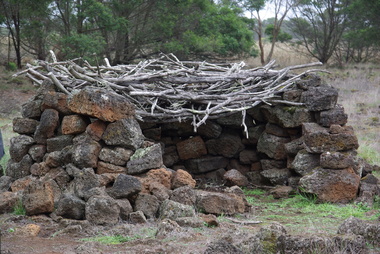
 Ballarat Heritage Services
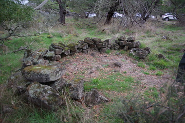
Photograph - Photograph - Colour, Aboriginal Rock Huts at Tyrendarra, 2016, 16/04/2016
... The Budj Bim National Heritage Landscape - Tyrendarra Area on the Australian National Heritage List lies on the Tyrendarra lava flow between the Fitzroy River and Darlot Creek close to the township. ...Ballarat Heritage Services PO Box 2209 Bakery Hill Post Office goldfields The Budj Bim National Heritage Landscape - Tyrendarra Area on the Australian National Heritage List lies on the Tyrendarra lava flow between the Fitzroy River and Darlot Creek close to the township. ...The Budj Bim National Heritage Landscape - Tyrendarra Area on the Australian National Heritage List lies on the Tyrendarra lava flow between the Fitzroy River and Darlot Creek close to the township. These photographs were taken during a guided tour with Gunditjmara guide Dennis Rose. Remains of stone shelters built and used by the Gunditj Mirring people.rock shelter, aboriginal, aborigines, tyrendarra, winda mara, dennis rose, budj bim national heritage landscape, gunditjmara -
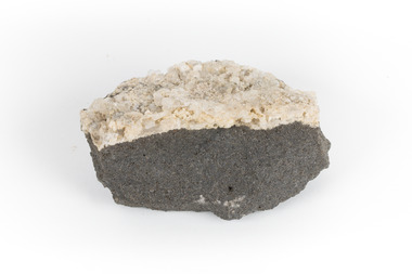 The Beechworth Burke Museum
Geological specimen - Hyalite in Basalt
... It is commonly formed as an extrusive rock, such as lava flow. It is one of the most common forms of rock underlying the earth's surface....It is commonly formed as an extrusive rock, such as lava flow. It is one of the most common forms of rock underlying the earth's surface. ...According to the 1912 Department of Mines Bulletin of the Geological Survey of Victoria, basalt covers a considerable portion of the Macedon area including Mount Macedon. Basalt is the most common form of rock underlying the earth's surface and is found in three kinds of rock forming environments: ocean divergent boundaries, oceanic hotspots, and mantle plumes and hotspots beneath continents.This specimen is part of a larger collection of geological and mineral specimens collected from around Australia (and some parts of the world) and donated to the Burke Museum between 1868-1880. A large percentage of these specimens were collected in Victoria as part of the Geological Survey of Victoria that begun in 1852 (in response to the Gold Rush) to study and map the geology of Victoria. Collecting geological specimens was an important part of mapping and understanding the scientific makeup of the earth. Many of these specimens were sent to research and collecting organisations across Australia, including the Burke Museum, to educate and encourage further study.A solid mass, geological specimen in shades of grey and white. Hyalite is a colourless variety of opal. It occurs as globular and botryoidal masses and irregular crusts in volcanic and pegmatite environments where the silica deposits from the gas phase. Basalt is dark in colour, fine-grained igneous rock composed of plagioclase and pyroxene minerals. It is commonly formed as an extrusive rock, such as lava flow. It is one of the most common forms of rock underlying the earth's surface.burke museum, geological specimen, department of mines, geological survey of victoria, basalt, mount macedon, beechworth -
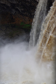 Ballarat Heritage Services
Photograph - Photograph - Colour, Wannon Falls, 2012, 18/08/2012
... The falls were created by basalt lava flow that surged up stream to the Wannon River....The falls were created by basalt lava flow that surged up stream to the Wannon River. warrnambool hopkins river mouth sea wannon falls Colour photographs of Wannon Falls, Victoria. ...Located 20km from Hamilton and around 15 km from Coleraine, the Wannon Falls present a spectacular display of water flowing down the falls into a deep plunge pool below. The falls were created by basalt lava flow that surged up stream to the Wannon River.Colour photographs of Wannon Falls, Victoria.warrnambool, hopkins river, mouth, sea, wannon falls -
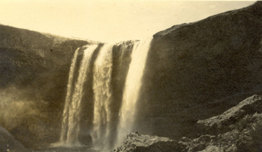 Federation University Historical Collection
Photograph, Wannan Falls near Hamilton
... Wannon Falls were created by lava flows that surged upstream to the Wannon River. ...Barker Library (top floor) Mount Helen goldfields Wannon Falls were created by lava flows that surged upstream to the Wannon River. ...Wannon Falls were created by lava flows that surged upstream to the Wannon River. The cascade is a 30 metre vertical drop into a deep plunge pool. Downstream rapids wind their way around large blocks of basalt. The Wannon Falls have been painted by notable artists such as Nicholas Chevalier, Eugene von Guerard, Thomas Clark and Louis Buvelot.Black and white photograph of a waterfall cascade known as Wannon Falls.Verso in black ink handwriting 'Wannon Falls near Hamilton'chatham family archive, chatham, wannon falls, hamilton, waterfall -
 Ballarat Heritage Services
Photograph - Colour, Aboriginal Rock Hut recreations at Tyrendarra, 2016, 16/04/2016
... The Budj Bim National Heritage Landscape - Tyrendarra Area on the Australian National Heritage List lies on the Tyrendarra lava flow between the Fitzroy River and Darlot Creek close to the township. ...Ballarat Heritage Services PO Box 2209 Bakery Hill Post Office goldfields The Budj Bim National Heritage Landscape - Tyrendarra Area on the Australian National Heritage List lies on the Tyrendarra lava flow between the Fitzroy River and Darlot Creek close to the township. ...The Budj Bim National Heritage Landscape - Tyrendarra Area on the Australian National Heritage List lies on the Tyrendarra lava flow between the Fitzroy River and Darlot Creek close to the township. The Budj Bim Cultural Landscape was ascribed on the UNESCO World Heritage List on 06 July 2019 (AEST). These photographs were taken during a guided tour with Gunditjmara guide Dennis Rose.Remains of stone shelters built and used by the Gunditj Mirring people.rock shelter, aboriginal, aborigines, tyrendarra, winda mara, rock hut, gunditjmara, unesco world heritage -
 The Beechworth Burke Museum
Geological specimen - Ropy Lava
... It occurs in specific lava flows that are slow moving and slow cooling, allowing for unique formations to be created out of the motion. ...It occurs in specific lava flows that are slow moving and slow cooling, allowing for unique formations to be created out of the motion. ...‘Ropy lava’ is known for its sculptural and layered qualities. It occurs in specific lava flows that are slow moving and slow cooling, allowing for unique formations to be created out of the motion. Ropy Lava is a flow that has a hardened crust with molten material underneath, the tension between these states is what creates its characteristic form. The brown/red hue of the stone is an indication of age, as it is oxidised iron deposits. This rock deposit is thought to be sourced from the area by Talbot, in western Victoria. This area has a rich mineral history and experienced the gold rush in the 1850's. The traditional owners of this area are the Dja Dja Wurrung people.This geological specimen shows the conditions in which the Australian landscape was created as well as provides an indication as to how these events occurred. It is representative of a common natural process that contextualises the formation of Australia with the formation of other landmasses. This specimen is part of a larger collection of geological and mineral specimens collected from around Australia (and some parts of the world) and donated to the Burke Museum between 1868-1880. A large percentage of these specimens were collected in Victoria as part of the Geological Survey of Victoria that begun in 1852 (in response to the Gold Rush) to study and map the geology of Victoria. Collecting geological specimens was an important part of mapping and understanding the scientific makeup of the earth. Many of these specimens were sent to research and collecting organisations across Australia, including the Burke Museum, to educate and encourage further study.Hand sized specimen in brown/red hues42 / victoria, talbot, lava, ropy, ropy lava, mineral, geological specimen, geological, geological heritage, natural stone, natural history -
 Merri-bek City Council
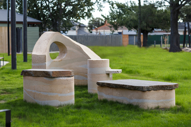
Sculpture - Rammed earth, basalt, mudstone, Isadora Vaughan, Terra Pneumatics, 2021
... The City of Merri-bek and Glenroy lie on the Western Basalt plains of Victoria, with soil and bluestone derived from ancient volcanic lava flows. Vaughan’s sculpture is created from these locally found sediments with the range of colours and textures reflecting the changing use of the land as various soils, rocks and sand were introduced from the coastal areas of Victoria. ...The City of Merri-bek and Glenroy lie on the Western Basalt plains of Victoria, with soil and bluestone derived from ancient volcanic lava flows. Vaughan’s sculpture is created from these locally found sediments with the range of colours and textures reflecting the changing use of the land as various soils, rocks and sand were introduced from the coastal areas of Victoria. ...Located at the Glenroy Community Hub, Isadora Vaughan’s rammed earth and bluestone sculpture draws attention to the continual transformation of Glenroy’s geology and its communities. The City of Merri-bek and Glenroy lie on the Western Basalt plains of Victoria, with soil and bluestone derived from ancient volcanic lava flows. Vaughan’s sculpture is created from these locally found sediments with the range of colours and textures reflecting the changing use of the land as various soils, rocks and sand were introduced from the coastal areas of Victoria. These forms reflect Glenroy’s changing communities, emphasising our relationship with the earth, and have been shaped to enable connection through offering places to sit, lean, play and to gather. Terra Pneumatics embodies the history and sediment of Glenroy —both human and geological — and invites the community to become part of this process of layering and transformation.merri-bek public art collection -
 The Beechworth Burke Museum
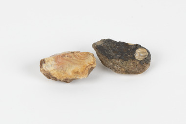
Geological specimen - Unknown, possible Carnelian Agate or Chalcedony
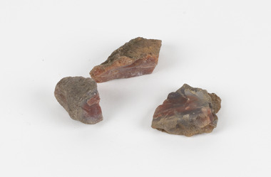
... Agate occurs when amygdales (gas pockets) form in the upper levels of basaltic lava flows. If these pockets or bubbles are iniltrated by water bearing silica in solution, the fluid dries and hardens in layers, forming round or egg shaped nodules or geodes within the rocky matrix. ...Agate occurs when amygdales (gas pockets) form in the upper levels of basaltic lava flows. If these pockets or bubbles are iniltrated by water bearing silica in solution, the fluid dries and hardens in layers, forming round or egg shaped nodules or geodes within the rocky matrix. ...Although it is not known where these specimens were collected, Victoria and other regions of Australia were surveyed for sites of potential mineral wealth throughout the 19th Century. The identification of sites containing valuable commodities such as gold, iron ore and gemstones in a locality had the potential to shape the development and history of communities and industries in the area. The discovery of gold in Victoria, for instance, had a significant influence on the development of the area now known as 'the goldfields', including Beechworth; the city of Melbourne and Victoria as a whole. Agate occurs when amygdales (gas pockets) form in the upper levels of basaltic lava flows. If these pockets or bubbles are iniltrated by water bearing silica in solution, the fluid dries and hardens in layers, forming round or egg shaped nodules or geodes within the rocky matrix. Agate is formed of a silica mineral chalcedony similar to quartz. The term carnelian primarily refers to the reddish shading of the stone; whether the stone is termed an agate or chalcedony type is often influenced by the degree of colour banding the specimen shows. The specimens are significant as examples of surveying activity undertaken to assess and direct the development of the mineral resource industries in Victoria and Australia, as well as the movement to expand human knowledge of earth sciences such as mineralogy and geology in the nineteenth century.Three small geological specimens that appear visually consistent with images of rough or unpolished Carnelian Agate or Chalcedony. geological specimen, geology, geology collection, burke museum, beechworth, indigo shire, north-east victoria, gemstones, agate, carnelian -
 Ballarat Heritage Services
Photograph - Photograph - Colour, Kathleen Gervasoni, Red Rock, Alvie, 1989, 02/09/1989
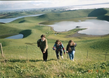
... There are some good views out to Lake Corangamite and the lava flows (probably from Warrion Hill) can be seen where they have entered the lake. ...There are some good views out to Lake Corangamite and the lava flows (probably from Warrion Hill) can be seen where they have entered the lake. ...Red Rock, Alvie, near Colac, is a complex of approximately 30 volcanic eruption points and is the Southern most of a chain of three volcanoes, the others being Warrion Hill and Alvie Hill. It is arguably the youngest eruption point in Victoria at around 8000 years, especially since the age of Mt Napier has been progressively pushed back. The highest point (on the Northern side) has many interesting features, including some awesome spatter ramparts. Driving around the rim to the south, you can also see layered tuff. There are some good views out to Lake Corangamite and the lava flows (probably from Warrion Hill) can be seen where they have entered the lake. Most of Red Rock is in private land, with two lookout points with some interpretive information. The water depicted in this photograph is not evident in 2019. Type: Volcanic Complex Location: South of Alvie, Victoria Last Eruption: 8000 years ago Access: Mostly private land, but there is an access road and some interpretive signage Visited: Visited Colour photograph of sisters Clare Gervasoni (left), Ann Gervasoni (centre) and Lisa Gervasoni and Red Rock, Alvie clare gervasoni, lisa gervasoni, ann gervasoni, red rock alvie -
 The Beechworth Burke Museum
Geological specimen - North Queensland Agates, Unknown
... Agate occurs when amygdales (gas pockets) form in the upper levels of basaltic lava flows. If these pockets or bubbles are iniltrated by water bearing silica in solution, the fluid dries and hardens in layers, forming round or egg shaped nodules or geodes within the rocky matrix. ...The Beechworth Burke Museum Loch Street Beechworth high-country Agate occurs when amygdales (gas pockets) form in the upper levels of basaltic lava flows. If these pockets or bubbles are iniltrated by water bearing silica in solution, the fluid dries and hardens in layers, forming round or egg shaped nodules or geodes within the rocky matrix. ...Agate occurs when amygdales (gas pockets) form in the upper levels of basaltic lava flows. If these pockets or bubbles are iniltrated by water bearing silica in solution, the fluid dries and hardens in layers, forming round or egg shaped nodules or geodes within the rocky matrix. Agate is formed of a silica mineral chalcedony similar to quartz. Although relatively common and semi-precious, agate has been prized since at least 1450 BC - an intricately carved agate seal was found in the 2015 excavation of a grave belonging to a Mycenaeum priest or warrior near Pylos in Greece. Agate is also used in jewellery and other decorative or ritual purposes due to its often striking appearance. These specimens originated in North Queensland, which contains noted agate-fossicking regions such as in the area surrounding Forsayth. They were collected in approximately 1852 as an adjunct to the Geological Survey of Victoria. It was donated to the Museum in 1868. Victoria and other regions of Australia were surveyed for sites of potential mineral wealth throughout the 19th Century. The identification of sites containing valuable commodities such as gold, iron ore and gemstones in a locality had the potential to shape the development and history of communities and industries in the area. The discovery of gold in Victoria, for instance, had a significant influence on the development of the area now known as 'the goldfields', including Beechworth; the city of Melbourne and Victoria as a whole. The specimens are significant as examples of surveying activity undertaken to assess and direct the development of the mineral resource industries in Victoria and Australia, as well as the movement to expand human knowledge of earth sciences such as mineralogy and geology in the nineteenth century. Two solid egg-sized pieces of peach/orange toned agate (a common semi-precious chalcedony, similar to quartz) with a striped pattern, embedded in a light and dark brown matrix. geological specimen, geology, geology collection, burke museum, beechworth, agate, north queensland agate, 1852 geological survey of victoria, l. hufer - donor, mineralogy, agate specimen, indigo shire -
 The Beechworth Burke Museum
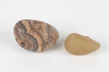
Geological specimen - Agate and Quartz pebbles
... Agate occurs when amygdales (gas pockets) form in the upper levels of basaltic lava flows. If these pockets or bubbles are iniltrated by water bearing silica in solution, the fluid dries and hardens in layers, forming round or egg shaped nodules or geodes within the rocky matrix. ...The Beechworth Burke Museum Loch Street Beechworth high-country Agate occurs when amygdales (gas pockets) form in the upper levels of basaltic lava flows. If these pockets or bubbles are iniltrated by water bearing silica in solution, the fluid dries and hardens in layers, forming round or egg shaped nodules or geodes within the rocky matrix. ...Agate occurs when amygdales (gas pockets) form in the upper levels of basaltic lava flows. If these pockets or bubbles are iniltrated by water bearing silica in solution, the fluid dries and hardens in layers, forming round or egg shaped nodules or geodes within the rocky matrix. Agate is formed of a silica mineral chalcedony similar to quartz. Although relatively common and semi-precious, agate has been prized since at least 1450 BC - an intricately carved agate seal was found in the 2015 excavation of a grave belonging to a Mycenaeum priest or warrior near Pylos in Greece. Agate is also used in jewellery and other decorative or ritual purposes due to its often striking appearance. Quartz is found all over Australia, including Beechworth in Victoria. It is formed in deep-seated igneous rocks and crystallized through hot aqueous solutions. It can have two forms; Microcrystalline quartz or Crystalline quartz. Microcrystalline quartz is a fine grain quartz where crystalline quartz is often a large crystal. The colour of quartz can vary. These specimens were collected in Victoria in the vicinity of the Burke Museum. Victoria and other regions of Australia were surveyed for sites of potential mineral wealth throughout the 19th Century. The identification of sites containing valuable commodities such as gold, iron ore and gemstones in a locality had the potential to shape the development and history of communities and industries in the area. The discovery of gold in Victoria, for instance, had a significant influence on the development of the area now known as 'the goldfields', including Beechworth; the city of Melbourne and Victoria as a whole.The specimens are significant as examples of surveying activity undertaken to assess and direct the development of the mineral resource industries in Victoria and Australia, as well as the movement to expand human knowledge of earth sciences such as mineralogy and geology in the nineteenth century.Geological specimens of Agate and Quartz respectively; the fist-sized piece of Agate has peach/coral colouring with grey concentric patterning and the smaller piece of quartz is a uniform yellow/orange shade. Existing label: Local pebbles / (agate and / quartz / (yellowish) / egg-shaped). / BB geological specimen, geology, geology collection, burke museum, beechworth, agate, quartz, north-east victoria, indigo shire, geological surveys -
 The Beechworth Burke Museum
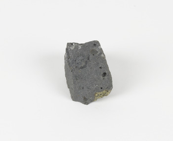
Geological specimen - Basalt (igneous-volcanic) containing Olivine, unknown
... In 1852, as part of the Victorian gold rush, gold was discovered in the immediate area, this gold was created by lava flows during the Newer Volcanic period, which were mined intensively during the nineteenth century. ...In 1852, as part of the Victorian gold rush, gold was discovered in the immediate area, this gold was created by lava flows during the Newer Volcanic period, which were mined intensively during the nineteenth century. ...This particular geological specimen was found in Mount Franklin or Lalgambook in Djadjawurrung, located between Daylesford and Newstead, approximately ninety minutes drive from Melbourne. The mountain is an example of a breached scoria cone (a steep conical hill of loose pyroclastic fragments) which was created by a volcanic eruption about 470,000 years ago, a date which may indicate the age of this geological specimen. The volcanic eruptions of Mount Franklin were most likely witnessed by members of the Dja Dja Wurrung Aboriginal tribe, who referred to this country as the 'smoking grounds'. Mount Franklin and the surrounding area appears to have been a place of considerable religious significance to Aboriginal people, there is evidence which indicates that frequent large ceremonial gatherings took place in the area. Basalt is the most common rock on Earth’s surface, more than 90% of all volcanic rock on Earth is basalt. Basalt is an aphanitic extrusive igneous rock formed from the rapid cooling of low-viscosity lava exposed at or very near the surface of a rocky planet or moon. Specimens are black in colour and weather to dark green or brown. Basalt is rich in iron and magnesium and is mainly composed of olivine, pyroxene, and plagioclase. Olivine is the name of a group of rock-forming silicate minerals with compositions ranging between Mg2SiO4 and Fe2SiO4. Unlike other minerals, Olivine has a very high crystallisation temperature which makes it the first of the minerals to crystallise from magma. As magma cools, the crystals begin to form and settle on the bottom of the lava and form basalts that are abnormally enriched in olivine in the lower part of lava flows. According to H. M. King (on geology.com) "Olivine is thought to be an important mineral in Earth's mantle. Its presence as a mantle mineral has been inferred by a change in the behaviour of seismic waves as they cross the boundary between Earth's crust and mantle". Lava from Mount Franklin and other volcanoes in the area filled valleys and buried the gold bearing streams that became the renowned ‘deep leads’ of the gold mining era. In 1852, as part of the Victorian gold rush, gold was discovered in the immediate area, this gold was created by lava flows during the Newer Volcanic period, which were mined intensively during the nineteenth century. Around 1865 the presence of a deep lead in Mount Franklin was established. Deep lead mining was initially unsuccessful, and it was not until the late 1870s that the Franklinford Gold Mining Company mined at Mount Franklin on a significant scale. A few years later the Mount Franklin Estate Gold Mining Company also struck gold, followed by the Shakespeare and Great Western companies in the mid-1880s. By the late 1880s, however, deep lead mining had ceased in the area. Soon after gold was discovered in 1851, Victoria’s Governor La Trobe wrote to the Colonial Office in London, urging ‘the propriety of selecting and appointing as Mineral Surveyor for this Colony a gentleman possessed of the requisite qualifications and acquaintance with geological science and phenomena’. Alfred Selwyn was appointed geological surveyor in Australia in 1852 which began the Geological Survey of Victoria. In 1853-69 the Geological Survey issued under Selwyn's direction sixty-one geological maps and numerous reports; they were of such high standard that a writer in the Quarterly Journal of the Geological Society of London bracketed the survey with that of the United States of America as the best in the world. During his years spent in Australia, Selwyn collected numerous significant geological specimens, examples of which are held in collections such as the Burke Museum.This geological specimen is an example of basalt and olivine which shows the volcanic lava activity and geographical specific nature of Mt Franklin as a significant volcanic site. According to Agriculture Victoria 'The crater is one of the deepest in the Central Highlands area. It is a major megacryst site with some of the largest known Victorian examples of megacrysts of augite and an orthoclase. The small parasitic mound of Lady Franklin on the western flanks adds to the geological interest of the site'. This specimen also highlights the locality as a significant place for both indigenous activity and Victorian gold rush era mining practices. This specimen is part of a larger collection of geological and mineral specimens collected from around Australia (and some parts of the world) and donated to the Burke Museum between 1868-1880. A large percentage of these specimens were collected in Victoria as part of the Geological Survey of Victoria that begun in 1852 (in response to the Gold Rush) to study and map the geology of Victoria. Collecting geological specimens was an important part of mapping and understanding the scientific makeup of the earth. Many of these specimens were sent to research and collecting organisations across Australia, including the Burke Museum, to educate and encourage further study.An angular, solid hand-sized piece of grey volcanic Basalt with green/brown Olivine phenocrysts along one flat edge.Olivine in basalt / - label is probably / correct. / C. Willman / 15/4/21burke museum, beechworth, indigo shire, beechworth museum, geological, geological specimen, mineralogy, basalt, igneous rock, igneous-volcanic, volcanic geology, volcanic, olivine, olivine specimen, basaltoid -
 The Beechworth Burke Museum
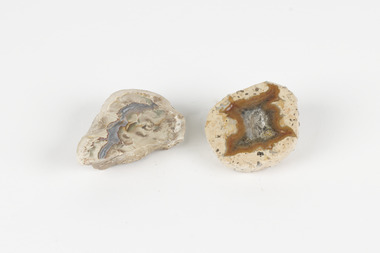
Geological specimen - Thunderegg agates, Unknown
... The specific locality of these specimens is unknown but they can be found in flows of rhyolite lava. They are formed in gas pockets in the lava, which act as moulds. ...The specific locality of these specimens is unknown but they can be found in flows of rhyolite lava. They are formed in gas pockets in the lava, which act as moulds. ...Thunderegg Agates are formed within rhyolite volcanic ash layers. They are rough spherical shapes, varying in size from less than an inch to over a metre long. Thundereggs usually contain centres of chalcedony which may have been fractured followed by deposition of agate, jasper or opal, either uniquely or in combination. A unique characteristic that these specimens have is the fact that they often look like ordinary rocks on the outside, but slicing them in half and polishing them may reveal intricate patterns and colours. These particular specimens are examples of thunderegg agates. Agate is a variety of chalcedony, a cryptocrystalline form of quartz. The agate component contributes to the intriguing internal patterns of the specimens. The specific locality of these specimens is unknown but they can be found in flows of rhyolite lava. They are formed in gas pockets in the lava, which act as moulds. These specimens can be found globally, with specific locations in Germany being particularly abundant. This specimen is part of a larger collection of geological and mineral specimens collected from around Australia (and some parts of the world) and donated to the Burke Museum between 1868-1880. A large percentage of these specimens were collected in Victoria as part of the Geological Survey of Victoria that begun in 1852 (in response to the Gold Rush) to study and map the geology of Victoria. Collecting geological specimens was an important part of mapping and understanding the scientific makeup of the earth. Many of these specimens were sent to research and collecting organisations across Australia, including the Burke Museum, to educate and encourage further study.Two small solid specimens with pale, sandy-coloured exteriors and fractured internal patterns. burke museum, beechworth, geological, geological specimen, thundereggs, thundereggs agate, agate, rhyolite, rhyolite lava, volcanic ash, chalcedony, cryptocrystalline -
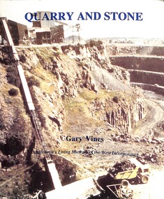 Sunshine and District Historical Society Incorporated
Book - Quarry and Stone, Melbourne's Living Museum of the West, 1993
... Sunshine and surrounding suburbs are located on the world's third largest flows of basaltic lava "Blue Stone". Settlers turned the quarrying industry into one of the largest in the area. ...Sunshine and surrounding suburbs are located on the world's third largest flows of basaltic lava "Blue Stone". Settlers turned the quarrying industry into one of the largest in the area. ...The history of quarrying bluestone in the 19th century in Melbourne's westSlim A 5 book, well-illustrated, and a picture of Market Street Quarry on the front covernon-fictionThe history of quarrying bluestone in the 19th century in Melbourne's westbluestone, quarry