Showing 7 items matching "leane drive"
-
 Eltham District Historical Society Inc
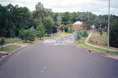
Photograph, Looking southeast along Leane Drive towards Main Road, Eltham, c.1989, 1989
... Looking southeast along Leane Drive towards Main Road, Eltham, c.1989...Alan Marshall Reserve, Eltham, Infrastructure, Leane Drive, Main Road, streets...Eltham District Historical Society Inc 728 Main Rd Eltham melbourne Alan Marshall Reserve, Eltham, Infrastructure, Leane Drive, Main Road, streets Kodak GA100 5095 Roll of 35mm colour negative film, 5 strips Also colour print Looking southeast along Leane Drive towards Main Road, Eltham, c.1989 Photograph ...Roll of 35mm colour negative film, 5 strips Also colour print Kodak GA100 5095alan marshall reserve, eltham, infrastructure, leane drive, main road, streets -
 Eltham District Historical Society Inc
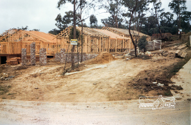
Photograph, Building development cnr Leane Drive and Long Valley Way, Eltham, 1985, 1985
... Building development cnr Leane Drive and Long Valley Way, Eltham, 1985......leane drive...Originally contained in a 2-ring PVC binder and document sleeves series 13 shire of eltham archives construction eltham long valley way houses leane drive Three colour photographs Building development cnr Leane Drive and Long Valley Way, Eltham, 1985 Photograph ...2 Long Valley Way, Eltham. Shire of Eltham Archives Series 13, Photograph Album, 1985. Originally contained in a 2-ring PVC binder and document sleevesThree colour photographsseries 13, shire of eltham archives, construction, eltham, long valley way, houses, leane drive -
 Eltham District Historical Society Inc
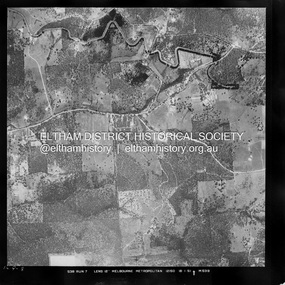
Photograph - Aerial Photograph, Landata, Eltham / Research, Vic, Jan. 1951
... ...Leane Drive...Centred on Brinkkotter Road opposite Yarramie Reserve, Eltham bounded by Maroondah Aqueduct to north, Nyora Road to south, Eltham College to east and Leane Drive to west. Historic Aerial Imagery Source: Landata.vic.gov.au Aerial Photo Details: Project No :65 Project : MELBOURNE AND METROPOLITAN PROJECT NO. 2 Run : 7 Frame : 8 Date : 01/1951 Film Type : B/W Camera : EAG9 Flying Height : 12200 Scale : 12000 Film Number : 1419 GDA2020 : 37°42'32"S, 145°10'41"E MGA2020 : 339408, 5824924 (55) Melways : 22 F3 (ed. 42)...Eltham District Historical Society Inc 728 Main Rd Eltham melbourne Centred on Brinkkotter Road opposite Yarramie Reserve, Eltham bounded by Maroondah Aqueduct to north, Nyora Road to south, Eltham College to east and Leane Drive to west. Historic Aerial Imagery Source: Landata.vic.gov.au Aerial Photo Details: Project No :65 Project : MELBOURNE AND METROPOLITAN PROJECT NO. 2 Run : 7 Frame : 8 Date : 01/1951 Film Type : B/W Camera : EAG9 Flying Height : 12200 Scale : 12000 Film Number : 1419 GDA2020 : 37°42'32"S, 145°10'41"E MGA2020 : 339408, 5824924 (55) Melways : 22 F3 (ed. 42) Historical aerial photos and photo maps provide viusal evidence of the chronology of changes to the built landscape of the district and assist in dating other images Aerial Photo 1951-01 Eltham Neil Webster Collection Brinkkotter Road Eltham College Leane Drive Maroondah Aqueduct Melways 22F3 Nyora Road Yarramie Reserve Digital jpg and electronic PDF file Eltham / Research, Vic. ...Centred on Brinkkotter Road opposite Yarramie Reserve, Eltham bounded by Maroondah Aqueduct to north, Nyora Road to south, Eltham College to east and Leane Drive to west. Historic Aerial Imagery Source: Landata.vic.gov.au Aerial Photo Details: Project No :65 Project : MELBOURNE AND METROPOLITAN PROJECT NO. 2 Run : 7 Frame : 8 Date : 01/1951 Film Type : B/W Camera : EAG9 Flying Height : 12200 Scale : 12000 Film Number : 1419 GDA2020 : 37°42'32"S, 145°10'41"E MGA2020 : 339408, 5824924 (55) Melways : 22 F3 (ed. 42)Historical aerial photos and photo maps provide viusal evidence of the chronology of changes to the built landscape of the district and assist in dating other imagesaerial photo, 1951-01, eltham, neil webster collection, brinkkotter road, eltham college, leane drive, maroondah aqueduct, melways 22f3, nyora road, yarramie reserve -
 Eltham District Historical Society Inc
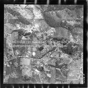
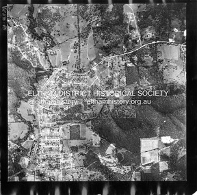
Photograph - Aerial Photograph, Landata, Eltham, Vic, Feb. 1956
... ...Leane Drive...Centred on present day Parsons Avenue at Leane Drive near the Maroondah Aqueduct, Eltham bounded by Lorimer Road to north, Thompson Crescent and Norman Road to south, Bells Hill Road to east and Parsons Road to west Historic Aerial Imagery Source: Landata.vic.gov.au Aerial Photo Details: Project No :250 Project : MELBOURNE OUTER SUBURBS PROJECT Run : 19 Frame : 5 Date : 02/1956 Film Type : B/W Camera : EAG9 Flying Height : 10000 Scale : 12000 Film Number : 1176 GDA2020 : 37°42'04"S, 145°11'09"E MGA2020 : 340064, 5825786 (55) Melways : 22 H1 (ed. 42)...Eltham District Historical Society Inc 728 Main Rd Eltham melbourne Centred on present day Parsons Avenue at Leane Drive near the Maroondah Aqueduct, Eltham bounded by Lorimer Road to north, Thompson Crescent and Norman Road to south, Bells Hill Road to east and Parsons Road to west Historic Aerial Imagery Source: Landata.vic.gov.au Aerial Photo Details: Project No :250 Project : MELBOURNE OUTER SUBURBS PROJECT Run : 19 Frame : 5 Date : 02/1956 Film Type : B/W Camera : EAG9 Flying Height : 10000 Scale : 12000 Film Number : 1176 GDA2020 : 37°42'04"S, 145°11'09"E MGA2020 : 340064, 5825786 (55) Melways : 22 H1 (ed. 42) Aerial Photo 1956-02 Neil Webster Collection Allendale Road Bells Hill Road Eltham Leane Drive Lorimer Road Maroondah Aqueduct Melway 22H1 Norman Road Parsons Road Research (Vic.) ...Centred on present day Parsons Avenue at Leane Drive near the Maroondah Aqueduct, Eltham bounded by Lorimer Road to north, Thompson Crescent and Norman Road to south, Bells Hill Road to east and Parsons Road to west Historic Aerial Imagery Source: Landata.vic.gov.au Aerial Photo Details: Project No :250 Project : MELBOURNE OUTER SUBURBS PROJECT Run : 19 Frame : 5 Date : 02/1956 Film Type : B/W Camera : EAG9 Flying Height : 10000 Scale : 12000 Film Number : 1176 GDA2020 : 37°42'04"S, 145°11'09"E MGA2020 : 340064, 5825786 (55) Melways : 22 H1 (ed. 42)aerial photo, 1956-02, neil webster collection, allendale road, bells hill road, eltham, leane drive, lorimer road, maroondah aqueduct, melway 22h1, norman road, parsons road, research (vic.), thompson crescent -
 Eltham District Historical Society Inc
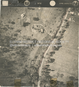
Photograph - Aerial Photograph, Main Road, Eltham near Leanne Drive, 2 Jul. 1951
... ...Leane Drive...Eltham District Historical Society Inc 728 Main Rd Eltham melbourne Not originally catalogued in Shire of Eltham Archives but from the same series of photos taken for Country Road Board study of Main Road widening shire of eltham archives Aerial Photo Country Roads Board Eltham Main Road Road widening Leane Drive 1951-07 Black and white proto print Size: 245x230 mm Condition: good Main Road, Eltham near Leanne Drive Photograph Aerial Photograph ...Not originally catalogued in Shire of Eltham Archives but from the same series of photos taken for Country Road Board study of Main Road wideningshire of eltham archives, aerial photo, country roads board, eltham, main road, road widening, leane drive, 1951-07 -
 Eltham District Historical Society Inc
Document - Property Binder, 1275 Main Road, Eltham
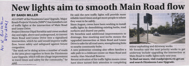
... ...Leane Drive...Newspaper article: New lights aim to smooth Main Road flow by Sandi Miller, Manningham and Nillumbik Bulletin, Novemebr 2021 Eltham Main Road Eltham Property Leane Drive Major Roads Project Victoria (MRPV) Fitzsimons Lane Upgrade Miscellaneous clippings, notes, photocopies, etc held on the subject property. 1275 Main Road, Eltham Document Property Binder ...Newspaper article: New lights aim to smooth Main Road flow by Sandi Miller, Manningham and Nillumbik Bulletin, Novemebr 2021eltham, main road eltham, property, leane drive, major roads project victoria (mrpv), fitzsimons lane upgrade -
 Eltham District Historical Society Inc
Photograph - Aerial Photograph, Landata, Eltham, Feb. 1956
... Centred on present day Shalbury Avenue, Eltham bounded by Leane Drive and Parsons Road to north, Nyora Road to south, Reynolds Road to east and the Diamond Creek to west Historic Aerial Imagery Source: Landata.vic.gov.au Aerial Photo Details: Project No :250 Project : MELBOURNE OUTER SUBURBS PROJECT Run : 18 Frame : 95 Date : 02/1956 Film Type : B/W Camera : EAG9 Flying Height : 10000 Scale : 12000 Film Number : 1176 GDA2020 : 37°41'57"S, 145°09'51"E MGA2020 : 338145, 5825965 (55) Melways : 22 C1 (ed. 42)...Eltham District Historical Society Inc 728 Main Rd Eltham melbourne Centred on present day Shalbury Avenue, Eltham bounded by Leane Drive and Parsons Road to north, Nyora Road to south, Reynolds Road to east and the Diamond Creek to west Historic Aerial Imagery Source: Landata.vic.gov.au Aerial Photo Details: Project No :250 Project : MELBOURNE OUTER SUBURBS PROJECT Run : 18 Frame : 95 Date : 02/1956 Film Type : B/W Camera : EAG9 Flying Height : 10000 Scale : 12000 Film Number : 1176 GDA2020 : 37°41'57"S, 145°09'51"E MGA2020 : 338145, 5825965 (55) Melways : 22 C1 (ed. 42) Aerial Photo 1956-02 Neil Webster Collection Eltham Diamond Creek (Creek) Melway 22C1 Nyora Road Parsons Road Reynolds Road Shalbury Avenue Digital jpg and electronic PDF file Eltham Photograph Aerial Photograph Landata ...Centred on present day Shalbury Avenue, Eltham bounded by Leane Drive and Parsons Road to north, Nyora Road to south, Reynolds Road to east and the Diamond Creek to west Historic Aerial Imagery Source: Landata.vic.gov.au Aerial Photo Details: Project No :250 Project : MELBOURNE OUTER SUBURBS PROJECT Run : 18 Frame : 95 Date : 02/1956 Film Type : B/W Camera : EAG9 Flying Height : 10000 Scale : 12000 Film Number : 1176 GDA2020 : 37°41'57"S, 145°09'51"E MGA2020 : 338145, 5825965 (55) Melways : 22 C1 (ed. 42)aerial photo, 1956-02, neil webster collection, eltham, diamond creek (creek), melway 22c1, nyora road, parsons road, reynolds road, shalbury avenue