Showing 16 items matching "lerderderg street land allotments"
-
![Map, Plan of Subdivision [Allotments along Lerderderg, George and McFarland Streets]](/media/collectors/5e461d8021ea67224c82f2a1/items/675d7243165f146b8adfc656/item-media/675d72d7165f146b8adfc859/item-fit-380x285.jpg?cb=6) Bacchus Marsh & District Historical Society
Bacchus Marsh & District Historical SocietyMap, Plan of Subdivision [Allotments along Lerderderg, George and McFarland Streets]
... ...Lerderderg Street Land Allotments...This map shows allotments of land on the northern side of Lerderderg Street from Gisborne Road through to the approximate site of the present day Bacchus Marsh Primary School. ...Single page map showing house block size land allotments in the Lerderderg, George Street and McFarland Street area of Bacchus Marsh with larger allotments north of this area towards Masons Lane also shown. ...Bacchus Marsh Victoria Maps Lerderderg Street Land Allotments McFarland Street Land Allotments Single page map showing house block size land allotments in the Lerderderg, George Street and McFarland Street area of Bacchus Marsh with larger allotments north of this area towards Masons Lane also shown. ...This map shows allotments of land on the northern side of Lerderderg Street from Gisborne Road through to the approximate site of the present day Bacchus Marsh Primary School. There are also allotments shown on the southern side of McFarland Street between George Street and Gisborne Road. Larger allotments of land are shown extending northwards towards Masons Lane. Inscribed at the top of the map are the words, 'Plan of Subdivision of Cr Pors (Crown Portions) 12 & 13 & Allotments 1,2,3,4, Block 3, Parish of Korkuperrimul, County of Bourke'. The date of the map has not been established but the absence of the Bacchus Marsh Primary School on the map suggests it may have been produced prior to 1865 when the primary school was built in Lerderderg Street.Single page map showing house block size land allotments in the Lerderderg, George Street and McFarland Street area of Bacchus Marsh with larger allotments north of this area towards Masons Lane also shown. Scale 150 feet to 1 inch. Part of a set of maps which are pasted into a bound volume containing 76 maps or plans in total. High resolution digital image stored on BMDHS computer network. bacchus marsh victoria maps, lerderderg street land allotments, mcfarland street land allotments -
![Map, Plan of Town Allotments Bacchus Marsh [1891-1897]](/media/collectors/5e461d8021ea67224c82f2a1/items/66acc1c90c778f9f64a3daec/item-media/66acc3990c778f9f64a3e09b/item-fit-380x285.jpg?cb=6) Bacchus Marsh & District Historical Society
Bacchus Marsh & District Historical SocietyMap, Plan of Town Allotments Bacchus Marsh [1891-1897]
... A single page paper plan showing allotments of land fronting Lerderderg and Bennett Street. Buildings, businesses and houses along most of the streets are identified by hand written annotations. ...Street which was constructed in 1898. Hence the date is sometime between 1891 and 1897. This plan of Bacchus Marsh is one of the most detailed visual representations of the location of shops, businesses and houses in the central part of Bacchus Marsh. It provides very precise locations of most of the shops and houses in the town in the 1890s. Bacchus Marsh Victoria Maps Shops Bacchus Marsh A single page paper plan showing allotments of land fronting Lerderderg ...This plan of town allotments in Lerderderg Street and Bennett Street also includes the location of many of the buildings, shops, businesses and houses which were present in the retail and business area of Bacchus Marsh in the 1890s. The precise date of the plan is not known but it must be sometime between 1891 and 1897. The Post Office and the Wesleyan Church are both shown on this plan. Both of these were constructed in 1890. The plan does not show the Baptist Church in Main Street which was constructed in 1898. Hence the date is sometime between 1891 and 1897.This plan of Bacchus Marsh is one of the most detailed visual representations of the location of shops, businesses and houses in the central part of Bacchus Marsh. It provides very precise locations of most of the shops and houses in the town in the 1890s. A single page paper plan showing allotments of land fronting Lerderderg and Bennett Street. Buildings, businesses and houses along most of the streets are identified by hand written annotations. Streets identified on plan: Lerderderg Street - Bennett Street - Main Street - Gell Street - Young Street - Graham Street. Physical boundaries of the map are: North border - Lerderderg Street - South border - Main Street - West border Gell Street - East border - Young Street. The plan is pasted into a bound volume containing 76 maps or plans in total. bacchus marsh victoria maps, shops bacchus marsh -
 Bacchus Marsh & District Historical Society
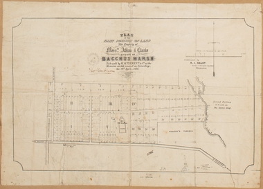
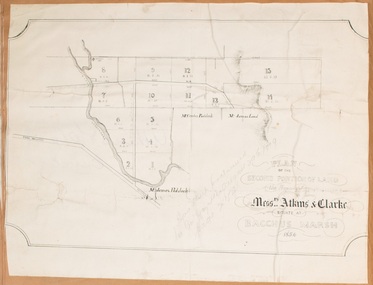
Map, Plan of the property of Messers Atkins and Clarke to be sold at the Mansion, Bacchus Marsh 19th April 1856. Copy 1
... allotments of land for sale. The subdivided land shown was owned by John Atkins and Robert Nalder Clarke, but previously owned by the Bacchus Family and was in and around their Manor House (Mansion) property in Bacchus Marsh.There are 5 portions of land further divided into numerous small portions. The land for sale is bounded by the present day streets of Main Street, Young Street, McFarland Street, Morton Streets, Crook Street, and part of the eastern section extends to the Lerderderg...Bacchus Marsh & District Historical Society Lerderderg Library Main Street Bacchus Marsh This plan of land allotments for sale indicates the property once owned by the Bacchus family in and around the township area of Bacchus Marsh. ...This plan of land allotments for sale indicates the property once owned by the Bacchus family in and around the township area of Bacchus Marsh. The Bacchus family sold their property in Bacchus Marsh to John Atkins and Robert Nalder Clarke in March 1851. Atkins and Clarke kept the property for a number of years until April 1856 when these allotments were put up for sale.This plan is almost identical to another copy held by the Bacchus Marsh and District Historical Society, VC Record 452, BMDHS collection). This plan, VC Record 707 Copy 1, contains a little more detail overall than VC Record 452 Copy 2, such as who did the survey work for the plan (R.C. Bagot) and who the selling agents were, (W.M. Tennent), and on the right side of the plan near the Lerderderg River is indicated the general area for a second parcel of land from this sale which is to be sold. There is also a compass illustration indicating north and south compass points.This is a very early land sales plan for the township of Bacchus Marsh and it therefore provides some clues as to how the early urban development of the township took place. Upon seeing the map in 1911 Bacchus Marsh Express newspaper editor Christopher Crisp wrote "The sale appears to have created the present township, which had a nucleus in earlier times further east", Express, 30 September, 1911, page 3.A single page paper plan showing allotments of land for sale. The subdivided land shown was owned by John Atkins and Robert Nalder Clarke, but previously owned by the Bacchus Family and was in and around their Manor House (Mansion) property in Bacchus Marsh.There are 5 portions of land further divided into numerous small portions. The land for sale is bounded by the present day streets of Main Street, Young Street, McFarland Street, Morton Streets, Crook Street, and part of the eastern section extends to the Lerderderg River. Scale: 8 chains to 1 inch The plan is pasted into a bound volume containing 76 maps or plans in total. BMDHS Loc: AR/B12/S4 Bacchus Marsh Township and Nearby Districts Maps Volume In-house Digital copies: BMDHS, Computer Network: Maps\Bacchus Marsh Township and Nearby Districts Maps VolumeHeading: Plan of the first portion of land. The property of Messers Atkins and Clarke situate at Bacchus Marsh. To be sold by W.M. Tennent & Co. at the Mansion on the Ground on Saturday the 19th April 1856. Below heading: Jas Ferguson, Lithographer On upper right side: Subdivided by R.C. Bagot London and Liverpool Chambers, Melbourne. 'Thos Taubman'. Post Office Stamp: BACCHUS MARSH VICTORIA MY 6, 63bacchus marsh victoria maps, bacchus family, land sales, manor house bacchus marsh -
 Bacchus Marsh & District Historical Society
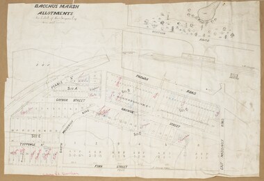
Map, Gaynor Street Land Sales, Maddingley, circa 1880s-1890s
... Lerderderg Library Main Street Bacchus Marsh This map was produced for a major sale of land in the Maddingley area of Bacchus Marsh. The precise date of the sale has not been determined. Features present on the map such as the Bacchus Marsh Railway Station indicate the land sale must have taken place some time after 1887 when the Railway Station opened. Bacchus Marsh Victoria Maps Maddingley Victoria Maps Land Use Maddingley Victoria History Land Sales Bacchus Marsh Land Sales Maddingley A single page paper map showing land allotments ...This map was produced for a major sale of land in the Maddingley area of Bacchus Marsh. The precise date of the sale has not been determined. Features present on the map such as the Bacchus Marsh Railway Station indicate the land sale must have taken place some time after 1887 when the Railway Station opened. A single page paper map showing land allotments for sale in the Maddingley area of Bacchus Marsh. Locations shown include Gaynor Street, Maddingley Road South, Parwan Road, Mitchem Street, Typpynge Street, Finn Street and East Maddingley Road. . The map is pasted into a bound volume containing 76 maps or plans in total. High resolution digital image stored on BMDHS computer network. bacchus marsh victoria maps, maddingley victoria maps, land use, maddingley victoria history, land sales bacchus marsh, land sales maddingley -
 Bacchus Marsh & District Historical Society
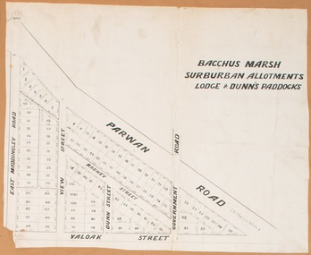
Map, Bacchus Marsh Suburban Allotments Parwan Road Lodge & Dunn's Paddocks 1888
... Bacchus Marsh & District Historical Society Lerderderg Library Main Street Bacchus Marsh This map was created as a plan for an auction of land close to the Bacchus Marsh Railway Station. The auction took place on 23 October 1888. 102 allotments ...This map was created as a plan for an auction of land close to the Bacchus Marsh Railway Station. The auction took place on 23 October 1888. 102 allotments of land from an area known as Lodge and Dunn's paddocks was offered for sale. A single page paper map showing allotments of land for sale along the Parwan Road in Maddingley. The map is pasted into a bound volume containing 76 maps or plans in total. High resolution digital image stored on BMDHS computer network. land sales bacchus marsh, land sales maddingley, bacchus marsh victoria maps, maddingley victoria maps -
 Bacchus Marsh & District Historical Society
Map, Atkins and Clarke Land Sale situate at Bacchus Marsh 1856 Copy 2
... Bacchus Marsh & District Historical Society Lerderderg Library Main Street Bacchus Marsh This plan of land allotments for sale indicates the property once owned by the Bacchus family in and around the township area of Bacchus Marsh. ...This plan of land allotments for sale indicates the property once owned by the Bacchus family in and around the township area of Bacchus Marsh. The Bacchus family sold their property in Bacchus Marsh to John Atkins and Robert Nalder Clarke in March 1851. Atkins and Clarke kept the property for a number of years until April 1856 when these allotments were put up for sale.This plan is almost identical to another copy held by the Bacchus Marsh and District Historical Society, VC Record 707, BMDHS collection). This plan, VC Record 452 Copy 2, contains a less detail than than VC Record 707 Copy 1. For example the selling agents and the surveyor who created the plan are not indicated on this copy of the plan. This copy of the plan does indicate the name Crook Street on the map. As the Crook family were the buyers of the Manor House property and surrounding land from Atkins and Clarke in 1856 it suggests that this copy is a later one of the earlier version. It is unlikely that the Crook family would have had the adjacent street named after them prior to purchasing the house and property. This is a very early land sales plan for the township of Bacchus Marsh and it therefore provides some clues as to how the early urban development of the township took place. Upon seeing the map in 1911 Bacchus Marsh Express newspaper editor Christopher Crisp wrote "The sale appears to have created the present township, which had a nucleus in earlier times further east", Express, 30 September, 1911, page 3. A single page paper map showing a portions of land available for sale in Bacchus Marsh in 1856. The subdivided land shown was owned by John Atkins and Robert Nalder Clarke, but previously owned by the Bacchus Family and was in and around their Manor House (Mansion) property in Bacchus Marsh.There are 5 portions of land further divided into numerous small portions. The land for sale is bounded by the present day streets of Main Street, Young Street, McFarland Street, Morton Streets, Crook Street, and part of the eastern section extends to the Lerderderg River. Scale: 4 chains to 1 inch. The map is pasted into a bound volume containing 76 maps or plans in total. High resolution digital image stored on BMDHS computer network. Plan of the first portion of land. The property of Messers Atkins and Clarke situate at Bacchus Marsh.land sales, land sales bacchus marsh, manor house bacchus marsh, crook family bacchus marsh -
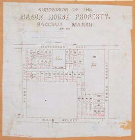 Bacchus Marsh & District Historical Society
Map, Subdivision of the Manor House Property Bacchus Marsh c.1908
... This included the large stone home known as the Manor House and various parcels of land including around 50 allotments of land near the Manor House, bounded by Young, Lerderderg, Crook and Main Streets. ...This included the large stone home known as the Manor House and various parcels of land including around 50 allotments of land near the Manor House, bounded by Young, Lerderderg, Crook and Main Streets. ...This land sales plan shows allotments of land offered for sale in the inner township area of Bacchus Marsh in 1908. The land put up for sale was from the estate of the late Mr and Mrs J.E. Crook. That being James Elijah Crook and his wife Harriet, (nee Athorn). The Crooks had been resident in Bacchus Marsh since the 1840s and were prominent members of the community. They were prominent in the business, social and civic affairs of the town and district. In the 1850s the Crooks acquired the Manor House and nearby land once owned by the Bacchus family. James Crook died in 1889. When Harriet Crook died in February 1908 their estate was offered for sale. This included the large stone home known as the Manor House and various parcels of land including around 50 allotments of land near the Manor House, bounded by Young, Lerderderg, Crook and Main Streets. Most of these allotments of land were sold in October 1908. The Manor House itself was passed in at the sale and continued to be owned by the Crook family for several decades after 1908.A single page map on a single page of a bound volume of maps. The map shows portions of land for sale from the subdivision of the Manor House property in Bacchus Marsh in 1908. The names of most of the buyers of the portions of land have been hand-written into the various allotments they purchased. The maps are pasted into a bound volume containing 76 maps or plans in total. High resolution digital image stored on BMDHS computer network. bacchus marsh victoria maps, land sales bacchus marsh, manor house bacchus marsh, crook family bacchus marsh -
 Bacchus Marsh & District Historical Society
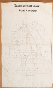
Map, Landsberg Estate Blackwood
... Lerderderg Library Main Street Bacchus Marsh The date this map was created has not been identified. It was possibly created at the time the Landsberg Estate near Blackwood was subdivided and sold into smaller lots in December 1886. Bacchus Marsh Victoria Maps Landsberg Estate Blackwood Single page map showing land allotments ...The date this map was created has not been identified. It was possibly created at the time the Landsberg Estate near Blackwood was subdivided and sold into smaller lots in December 1886.Single page map showing land allotments which made up the Landsberg Estate near Blackwood. Scale 20 chains to 1 inch. The map is pasted into a bound volume containing 76 maps or plans in total. High resolution digital image stored on BMDHS computer network. bacchus marsh victoria maps, landsberg estate blackwood -
 Bacchus Marsh & District Historical Society
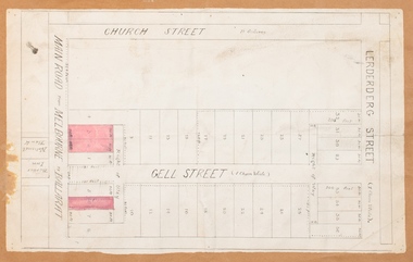
Map, Main Road and Gell Street Allotments
... This map shows allotments of land along Gell Street Bacchus Marsh running between Main Road (now called Main Street) and Lerderderg Street. ...Bacchus Marsh & District Historical Society Lerderderg Library Main Street Bacchus Marsh This map shows allotments of land along Gell Street Bacchus Marsh running between Main Road (now called Main Street) and Lerderderg Street. ...This map shows allotments of land along Gell Street Bacchus Marsh running between Main Road (now called Main Street) and Lerderderg Street. The total area of the map encompasses Main Road, Church Street, Lerderderg Street and Gell Street. 36 allotments of land are shown. Three allotments which connect to Main Road are shaded in pink. The date of the map has not been established but the National Bank building erected in 1865 near the Border Inn is indicated which indicates that the map dates from after 1865. Reports in the Bacchus Marsh Express newspaper on 5 March 1870, page 2, column 6 announced building lots in Gell Street had been withdrawn from sale by the agent J.E. Crook. Later reports in the Express on 1 November 1873, page 2, column 2 advertised 14 allotments of land in Gell Street for sale. Single page map showing allotments of land along the Main Road (Main Street) and Gell Street areas of Bacchus Marsh. Part of a set of maps which are pasted into a bound volume containing 76 maps or plans in total. High resolution digital image stored on BMDHS computer network. bacchus marsh victoria maps, gell street land allotments, main street land allotments -
 Bacchus Marsh & District Historical Society
Map, Gaynor Street Area Land Sales, Maddingley, 1888
... Lerderderg Library Main Street Bacchus Marsh This map was produced for a major sale of land in the Maddingley area of Bacchus Marsh in 1888. The sale was conducted by two firms from Melbourne, Carney and Kelly 12 Swanston Street Melbourne. and 'Richardson, Kerr & Co. 40 Flinders Lane Melbourne. 136 blocks were for sale. Bacchus Marsh Victoria Maps Maddingley Victoria Maps Land Use Maddingley Victoria History Land Sales Bacchus Marsh Land Sales Maddingley A single page paper map showing land allotments ...This map was produced for a major sale of land in the Maddingley area of Bacchus Marsh in 1888. The sale was conducted by two firms from Melbourne, Carney and Kelly 12 Swanston Street Melbourne. and 'Richardson, Kerr & Co. 40 Flinders Lane Melbourne. 136 blocks were for sale.A single page paper map showing land allotments for sale in the Maddingley area of Bacchus Marsh. Locations shown include Gaynor Street, Maddingley Road South, Parwan Road, Mitchem Street, Typpynge Street, Finn Street and East Maddingley Road. . The map is pasted into a bound volume containing 76 maps or plans in total. High resolution digital image stored on BMDHS computer network. bacchus marsh victoria maps, maddingley victoria maps, land use, maddingley victoria history, land sales bacchus marsh, land sales maddingley -
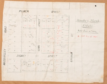 Bacchus Marsh & District Historical Society
Map, Bacchus Marsh Estate sold 30th June 1888 and sold 28 December 1895
... Lerderderg Library Main Street Bacchus Marsh Blocks of land in this area of Bacchus Marsh were sold in lots between 1888 and the late 1890s. This map shows sales made in 1888 and 1895. Bacchus Marsh Victoria Maps Land Sales Bacchus Marsh Pilmer Street Bacchus Marsh Graham Street Bacchus Marsh Sydney Street Bacchus Marsh Como Street Bacchus Marsh Maddingley Road Bacchus Marsh Grant Street Bacchus Marsh Single page map showing allotments of land bounded by Pilmer Street, Graham Street, Sydney Street and Maddingley Road (Grant Street) in Bacchus Marsh.The area is dissected by Como Street down the central area. 43 blocks of land are shown with the names of buyers or sellers in 1888 written in black in. ...Blocks of land in this area of Bacchus Marsh were sold in lots between 1888 and the late 1890s. This map shows sales made in 1888 and 1895.Single page map showing allotments of land bounded by Pilmer Street, Graham Street, Sydney Street and Maddingley Road (Grant Street) in Bacchus Marsh.The area is dissected by Como Street down the central area. 43 blocks of land are shown with the names of buyers or sellers in 1888 written in black in. Buyers or sellers for December 1895 are written in red ink. Part of a set of maps which are pasted into a bound volume containing 76 maps or plans in total. High resolution digital image stored on BMDHS computer network. bacchus marsh victoria maps, land sales bacchus marsh, pilmer street bacchus marsh, graham street bacchus marsh, sydney street bacchus marsh, como street bacchus marsh, maddingley road bacchus marsh, grant street bacchus marsh -
 Bacchus Marsh & District Historical Society
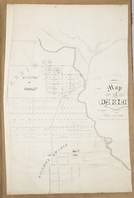
Map, 'Map of Darley' circa 1877-1897
... Lerderderg Library Main Street Bacchus Marsh This map shows the early laid out streets and roads for the village of Darley and the main roads and streets in the central area of the township of Bacchus Marsh. The date of the map is not known. Landmarks indicated on the map including the Anglican Church in Church Street (Gisborne Road), opposite the Presbyterian Church, and the Baptist Church at its pre-1898 Main Street location suggest the map is dated between 1877 and 1897. Landholders names can be seen on some of the allotments of land ...This map shows the early laid out streets and roads for the village of Darley and the main roads and streets in the central area of the township of Bacchus Marsh. The date of the map is not known. Landmarks indicated on the map including the Anglican Church in Church Street (Gisborne Road), opposite the Presbyterian Church, and the Baptist Church at its pre-1898 Main Street location suggest the map is dated between 1877 and 1897. Landholders names can be seen on some of the allotments of land marked in this map, including the names Clifton, Cosgrove, O'Hagan, McFarlane, Nagle, O'Hagan, Simpson and Vallence.A single page paper map showing the village of Darley and the township of Bacchus Marsh. Scale 10 chains to 1 inch. The map is pasted into a bound volume containing 76 maps or plans in total. High resolution digital image stored on BMDHS computer network. darley victoria maps, bacchus marsh victoria maps -
 Bacchus Marsh & District Historical Society
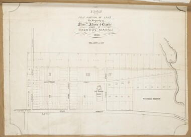
Map, Plan of the second portion of the property of Messers Atkins and Clarke situate at Bacchus Marsh 1856
... Bacchus Marsh & District Historical Society Lerderderg Library Main Street Bacchus Marsh This plan of land allotments for sale indicates part of the property once owned by the Bacchus family in and around the township area of Bacchus Marsh. ...This plan of land allotments for sale indicates part of the property once owned by the Bacchus family in and around the township area of Bacchus Marsh. The Bacchus family sold their property in Bacchus Marsh to John Aitkins and Robert Nalder Clarke in March 1851. Aitkins and Clarke kept the property for a number of years until April 1856 when these allotments were put up for sale.This is a very early land sales plan for agricultural land close to the township of Bacchus Marsh. It therefore provides some clues as to how the early urban development of the township and agricultural development of the nearby area took place. Upon seeing the map in 1911 Bacchus Marsh Express newspaper editor Christopher Crisp wrote "The sale appears to have created the present township, which had a nucleus in earlier times further east", Express, 30 September, 1911, page 3.A single page paper plan showing allotments of land for sale. The subdivided land shown was owned by John Aitkins and Robert Nalder Clarke, but previously owned by the Bacchus Family and was in and around their Manor House (Mansion) property in Bacchus Marsh. This plan shows allotments in the second portion of land to be sold which was located east of the Manor House on the eastern side of the Lerderderg River. The land for sale was made up of 15 allotments. The plan is pasted into a bound volume containing 76 maps or plans in total. BMDHS Loc: AR/B12/S4 Bacchus Marsh Township and Nearby Districts Maps Volume In-house Digital copies: BMDHS, Computer Network: Maps\Bacchus Marsh Township and Nearby Districts Maps Volumebacchus marsh victoria maps, bacchus family, land sales, manor house bacchus marsh -
 Bacchus Marsh & District Historical Society
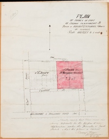
Map, Plan of Survey of Part of Crown Allotment 9, Parish of Korkuperrimul, 1890
... Bacchus Marsh & District Historical Society Lerderderg Library Main Street Bacchus Marsh This map documents a transfer of an allotment of land in Clarke Street Bacchus Marsh in 1890. ...This map documents a transfer of an allotment of land in Clarke Street Bacchus Marsh in 1890. Clarke Street is located on the eastern side of Bacchus Marsh not far from Main Street and Crook Street. It is now known as Candeloro Street. The map indicates J. Booth as the owner of the land and H. Simpson as the occupier. Next to this allotment is a an allotment of land owned by J. Elmore,Single page map showing Crown allotment 9, Parish of Korkuperrimul, County of Bourke. Scale 100 feet to inch. Part of a set of maps which are pasted into a bound volume containing 76 maps or plans in total. High resolution digital image stored on BMDHS computer network. At bottom of map: I hereby certify that I have made this survey expressly for the purpose of an application under the Transfer of Land Statute that this plan is correct. Barry B???, Lic. Surveyor, 16.10.90bacchus marsh victoria maps, clarke street bacchus marsh maps -
![Map, Plan of Town Allotments Bacchus Marsh [1873]](/media/collectors/5e461d8021ea67224c82f2a1/items/677a8ee7ab7bb47995c5573f/item-media/677a8fdeab7bb47995c55b56/item-fit-380x285.jpg?cb=6) Bacchus Marsh & District Historical Society
Bacchus Marsh & District Historical SocietyMap, Plan of Town Allotments Bacchus Marsh [1873]
... Streets, are also shown on this map. Land Sales Bacchus Marsh Bacchus Marsh Victoria Maps James Young 1816-1871 Bacchus Marsh Roads and Streets Bennett Street Bacchus Marsh A single page paper map showing 30 blocks of land for sale around 1873 in the vicinity of Bennett Street and Lerderderg Street. Described in contemorary sources as a 'lithographed copy'. No scale is indicated. The map is pasted into a bound volume containing 76 maps or plans in total. High resolution digital image stored on BMDHS computer network. Plan of Town Allotments ...James Young was a prominent businessman, land owner and public figure in the early colonial period of Bacchus Marsh. After his death in 1871 land remaining from his estate in Bacchus Marsh was sold at auction in 1873. The sale of his estate included the substantial stone residence in Bennett Street which later became known as 'Stone Villa'. The sale of his land in 1873 was conducted by local auctioneer James Crook. 29 allotments were advertised for sale, although the plan for the sale indicated 30 allotments. The sale notice in the Bacchus Marsh Express of 11 October 1873 noted that the allotments were " in the very centre and heart of the most populous and business portion of the township, at the same time being the only remaining portion of the business block available for purchase by public sale, which fact intending purchasers should not lose sight of, as the opportunity cannot occur again". The designation of a new street, 'Bennett Street', shown on the plan, is also indicated in the advertising, "In reference to the main street frontages, opposite the Border Flour Mills. The Auctioneer would also direct attention to the plan, showing the formation of a new thorough fare (Bennett street) leading from Young street into Gell street, thus opening up the township on the high, more healthy, and commanding position so much to be desired for private dwellings".An important cartographic document which indicates an early major subdivision of land in the inner urban area of the Bacchus Marsh township. This subdivision lead to the continuing residential and commercial development of the township of Bacchus Marsh in the later part of the 19th century. The location of two well known demolished public structures, the Free Gardeners Hall in Gell Street, and the Old Mechanics Institute Hall (aka the Buffs Hall), on the corner of Young and Bennett Streets, are also shown on this map.A single page paper map showing 30 blocks of land for sale around 1873 in the vicinity of Bennett Street and Lerderderg Street. Described in contemorary sources as a 'lithographed copy'. No scale is indicated. The map is pasted into a bound volume containing 76 maps or plans in total. High resolution digital image stored on BMDHS computer network. land sales bacchus marsh, bacchus marsh victoria maps, james young 1816-1871, bacchus marsh roads and streets, bennett street bacchus marsh -
 Bacchus Marsh & District Historical Society
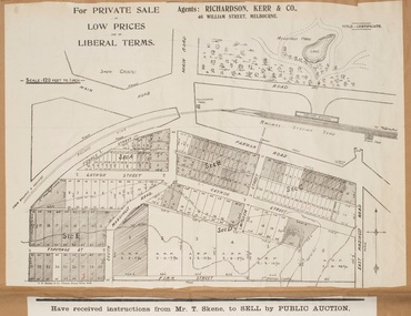
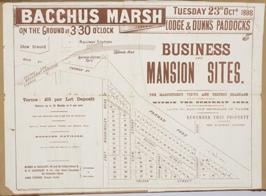
Map, Bacchus Marsh Tuesday 23rd Oct. 1888, Lodge & Dunn's Paddocks 1888. Business and Mansion Sites
... Bacchus Marsh & District Historical Society Lerderderg Library Main Street Bacchus Marsh This map was created as a plan for an auction of land close to the Bacchus Marsh Railway Station. The auction took place on 23 October 1888. 102 allotments ...This map was created as a plan for an auction of land close to the Bacchus Marsh Railway Station. The auction took place on 23 October 1888. 102 allotments of land from an area known as Lodge and Dunn's paddocks was offered for sale. The auction was conducted by auctioneers based in Melbourne and was advertised in Melbourne newspapers as well as in the Bacchus Marsh Express newspaper. The auction plan contains a range of details including the selling agents, Munro and Baillieu; W.P. Lockhart; and John Turner, all of Melbourne, deposit terms for purchases, price of railway passes for a return trip from Melbourne to Bacchus Marsh of 1 shilling, and a description of the land as having 'magnificent views and perfect drainage'. A single page paper map showing allotments of land for sale along the Parwan Road in Maddingley. The map is pasted into a bound volume containing 76 maps or plans in total. High resolution digital image stored on BMDHS computer network. At bottom on left side: 'Harston & Co. Lith, Melb.'land sales bacchus marsh, land sales maddingley, bacchus marsh victoria maps, maddingley victoria maps