Showing 106 items matching "local landmark"
-
 Greensborough Historical Society
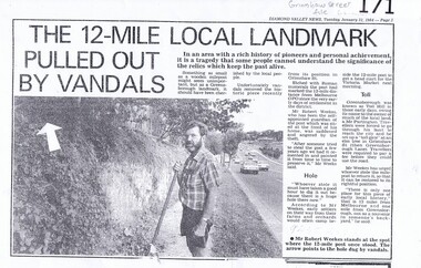
Newspaper clipping, Diamond Valley Leader, The 12-Mile Local Landmark Pulled Out By Vandals, 31/01/1984
... The 12-Mile Local Landmark Pulled Out By Vandals...The 12-Mile Local Landmark Pulled Out By Vandals Newspaper clipping Diamond Valley Leader ...A newspaper article relating the history, significance and later theft of a 12 Mile marker from the Grimshaw Street location were it had stood since the very early days of settlement of the district. The road marker had been a local landmark. A photocopy of an article fromt the Diamond Valley News.Nilgrimshaw street, melbourne gpo, 12 mile marker, greensborough -
 Tatura Irrigation & Wartime Camps Museum
Artwork, other - Plaque - wooden, Plaque wood burned original home, Rodney irrigation trust office, Dr Parks surgery, Mr & Mrs Reillys home, now Tatura Museum
... local landmark...Originally of the Rodney Irrigation Trust office, later Dr Parks Surgery, then Mr & Mrs Reilly's home, now Tatura museum Local Tatura History local landmark Front is covered by burned engraving of house and surrounds. on back written in blue pen, Bev Sheahan, 2/14 Ashenden St, Shepparton. ...Originally of the Rodney Irrigation Trust office, later Dr Parks Surgery, then Mr & Mrs Reilly's home, now Tatura museumLocal Tatura HistoryNatural wood slab, with original bark edging, burned engraving of the building which is now Tatura Museum. originally Rodney Irrigation Office, then Dr. Parks home and SurgeryFront is covered by burned engraving of house and surrounds. on back written in blue pen, Bev Sheahan, 2/14 Ashenden St, Shepparton. Ph 212282. CP 12132, 2 242098. Sticker Donor: Ian Glover sept 1998local landmark -
 Greensborough Historical Society
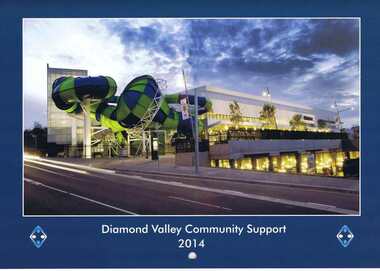
Calendar, Diamond Valley Community Support Inc. Annual Report 2012-2013. Calendar. 2014, 2012-2014
... Illustrations of local landmarks and shopping precincts.. ...Illustrations of local landmarks and shopping precincts.. Diamond Valley Community Support Inc. ...The annual report of Diamond Valley Community Support Inc. is presented in a calendar format. In this 2013 edition the calendar is illustrated with photographs of the local area.The annual report is a record of the activities and services of Diamond Valley Community Support Inc.28 pages. Colour and black and white illustration. Annual report in calendar format. Illustrations of local landmarks and shopping precincts.. diamond valley community support inc. -
Whitehorse Historical Society Inc.
Pamphlet, Whitehorse Road, Blackburn, 1/08/1999
... Auction. Historical local landmark house built c1905. The house has many original features....Auction. Historical local landmark house built c1905. The house has many original features. ...Whitehorse Road, Blackburn, No 73. Auction. Historical local landmark house built c1905. The house has many original features.whitehorse road, blackburn, auctions -
 Surrey Hills Historical Society Collection
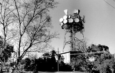
Photo, Telecom tower, Canterbury Road
... landmarks and houses of the area by Ken Hall in c1980. The PMG / Telecom / Telstra tower was built in 1961-1963 as a relay station to support television and radio links between city and regional broadcasting stations. The tower itself was 45 m in height with a 2 storey building for equipment and staff surrounded by garden. From the beginning it was opposed by local...A black and white photo of local landmark visible from many vantage points in Surrey Hills and surrounding area, as it was built on the high point of the area....The permit (to replace the tower) expired in September 2017. telecommunications tower city of whitehorse heritage overlay heritage study development pmg tower telstra telecom harding street canterbury road A black and white photo of local landmark visible from many vantage points in Surrey Hills and surrounding area, as it was built on the high point of the area. ...This photo of the Telecom Tower was one of a series of photos taken of landmarks and houses of the area by Ken Hall in c1980. The PMG / Telecom / Telstra tower was built in 1961-1963 as a relay station to support television and radio links between city and regional broadcasting stations. The tower itself was 45 m in height with a 2 storey building for equipment and staff surrounded by garden. From the beginning it was opposed by local residents. In response to a Telstra application to replace it with a 40m slimline monopole, the City of Whitehorse controversially sought to have the structure heritage-listed, a move which caused much debate. In May 2015 Council ultimately rescinded its decision and gave permission for demolition, however Telstra deemed the permit conditions to be too restrictive and decided to continue to use the tower. The permit (to replace the tower) expired in September 2017. A black and white photo of local landmark visible from many vantage points in Surrey Hills and surrounding area, as it was built on the high point of the area.telecommunications tower, city of whitehorse, heritage overlay, heritage study, development, pmg tower, telstra, telecom, harding street, canterbury road -
 Greensborough Historical Society
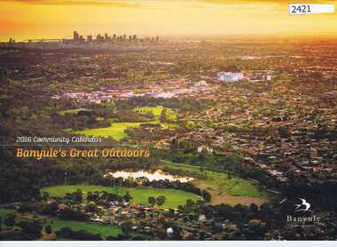
Calendar, Banyule City Council, Banyule Community Calendar 2016: Banyule's great outdoors, 2016_
... Illustrations of local scenes and landmarks....Illustrations of local scenes and landmarks. Banyule Community Calendar 2016: Banyule's great outdoors. ...This community calendar is distributed to residents of the City of Banyule each year. Each year it focusses on an aspect of the local community. The 2016 calendar contains photographs of local scenes and activities. Some council services are detailed in the back pages.The annual report is a record of the activities and services in the Banyule City Council area.28 pages. Colour illustrations. Illustrations of local scenes and landmarks.banyule city council, banyule community calendar -
 Greensborough Historical Society
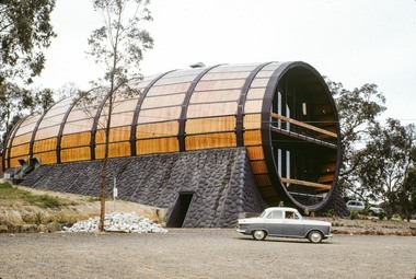
Photograph - Digital image, Eltham Barrel, 1970s
... A view of the Eltham Barrel, a restaurant built in the 1960s. This local landmark was destroyed by fire in 1989....Greensborough Historical Society 34A Glenauburn Road Lower Plenty Lower Plenty melbourne A view of the Eltham Barrel, a restaurant built in the 1960s. This local landmark was destroyed by fire in 1989. the eltham barrel Digital copy of colour photograph. ...A view of the Eltham Barrel, a restaurant built in the 1960s. This local landmark was destroyed by fire in 1989.Digital copy of colour photograph.the eltham barrel -
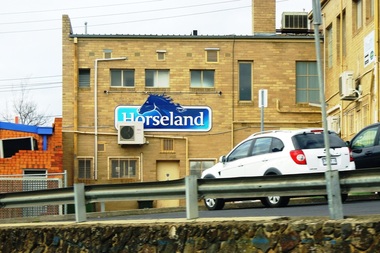
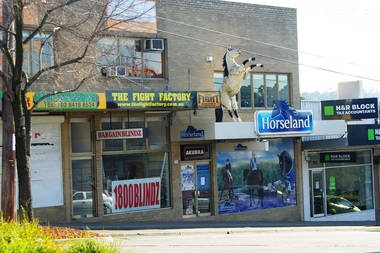
 Greensborough Historical Society
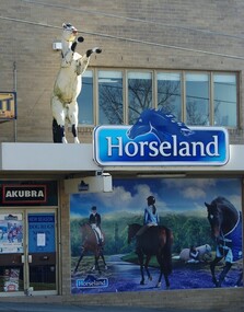
Photograph - Digital image, Marilyn Smith, Horseland Greensborough 1, 18/08/2015
... The Horseland store at 87 Main Street Greensborough was a local landmark with its model of a horse on the verandah roof. ...Greensborough Historical Society 34A Glenauburn Road Lower Plenty Lower Plenty melbourne The Horseland store at 87 Main Street Greensborough was a local landmark with its model of a horse on the verandah roof. ...The Horseland store at 87 Main Street Greensborough was a local landmark with its model of a horse on the verandah roof. This store closed late in 2015.The Horseland store was a symbol of Greensborough's past as a country town.Digital copy of colour photographhorseland greensborough, main street greensborough -
 Greensborough Historical Society
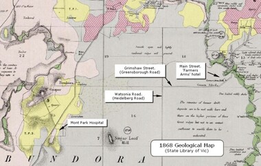
Map - Geological Map, 1868 Geological map of Greensborough (annotated), 1868_
... This geological map from the State Library of Victoria collection has been annotated by GHS member Ian Bryant to show some local landmarks...Greensborough Historical Society 34A Glenauburn Road Lower Plenty Lower Plenty melbourne This geological map from the State Library of Victoria collection has been annotated by GHS member Ian Bryant to show some local landmarks Greensborough - maps 1860s Melbourne suburbs geography roads Annotations on map show locations. ...This geological map from the State Library of Victoria collection has been annotated by GHS member Ian Bryant to show some local landmarksDigital copy of colour map.Annotations on map show locations.greensborough - maps, 1860s melbourne, suburbs, geography, roads -
 Greensborough Historical Society
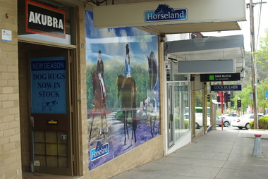
Photograph - Digital image, Marilyn Smith, Horseland Greensborough 3, 18/08/2015
... The Horseland store at 87 Main Street Greensborough was a local landmark with its model of a horse on the verandah roof. ...Greensborough Historical Society 34A Glenauburn Road Lower Plenty Lower Plenty melbourne The Horseland store at 87 Main Street Greensborough was a local landmark with its model of a horse on the verandah roof. ...The Horseland store at 87 Main Street Greensborough was a local landmark with its model of a horse on the verandah roof. This store closed late in 2015. This view shows the footpath in front of the store.The Horseland store was a symbol of Greensborough's past as a country town.Digital copy of colour photographhorseland greensborough, main street greensborough -
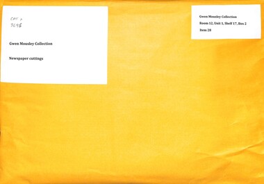 Sunshine and District Historical Society Incorporated
Archive - Gwen Mousley Newspaper cuttings primarily of local interest of Deer Park
... The cuttings include material on the lives and work of persons in Deer Park and Sunshine district and on local landmarks. Examples of people:- Beth Argyle, Andy Ross. ...The cuttings include material on the lives and work of persons in Deer Park and Sunshine district and on local landmarks. Examples of people:- Beth Argyle, Andy Ross. ...From Gwen Mousley Collectiondeer park, history -
 Greensborough Historical Society
Photograph - Digital image, Marilyn Smith, Horseland Greensborough from rear 1, 18/08/2015
... The Horseland store at 87 Main Street Greensborough was a local landmark with its model of a horse on the verandah roof. ...Greensborough Historical Society 34A Glenauburn Road Lower Plenty Lower Plenty melbourne The Horseland store at 87 Main Street Greensborough was a local landmark with its model of a horse on the verandah roof. ...The Horseland store at 87 Main Street Greensborough was a local landmark with its model of a horse on the verandah roof. This store closed late in 2015. This view shows the rear of the building, taken from Hailes Street.The Horseland store was a symbol of Greensborough's past as a country town.Digital copy of colour photographhorseland greensborough, main street greensborough -
 Greensborough Historical Society
Photograph - Digital image, Marilyn Smith, Horseland Greensborough from rear 2, 18/08/2015
... The Horseland store at 87 Main Street Greensborough was a local landmark with its model of a horse on the verandah roof. ...Greensborough Historical Society 34A Glenauburn Road Lower Plenty Lower Plenty melbourne The Horseland store at 87 Main Street Greensborough was a local landmark with its model of a horse on the verandah roof. ...The Horseland store at 87 Main Street Greensborough was a local landmark with its model of a horse on the verandah roof. This store closed late in 2015. This view shows the rear of the building, taken from Hailes Street.The Horseland store was a symbol of Greensborough's past as a country town.Digital copy of colour photographhorseland greensborough, main street greensborough -
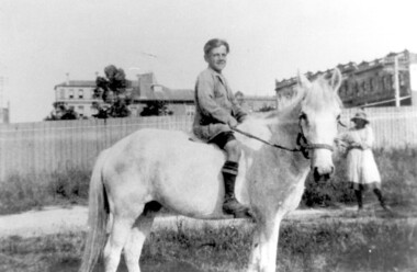 Surrey Hills Historical Society Collection
Photograph, Bill Willaton on one of Tacey's butcher's shop delivery horses, c 1920, 1920
... In the background a girl is standing in front of a new-looking paling fence behind which can be seen local landmarks. On the right is Hansen's Terrace; on the far left part of the Surrey Hall can be seen and in the middle ground the rear of McNeill's Family Hotel (Surrey Lodge), Dartnell's corner and the side of the post office....In the background a girl is standing in front of a new-looking paling fence behind which can be seen local landmarks. On the right is Hansen's Terrace; on the far left part of the Surrey Hall can be seen and in the middle ground the rear of McNeill's Family Hotel (Surrey Lodge), Dartnell's corner and the side of the post office. ...The date is approximate. Bill Willaton was a driver for C E Gray & Son, bakers of Canterbury during the 1930s. Tacey's butcher shop (dem) was located at 629 Canterbury Road. Black and white photo of a young boy on a light-coloured horse in vacant land adjacent to Canterbury Road, Surrey Hills. In the background a girl is standing in front of a new-looking paling fence behind which can be seen local landmarks. On the right is Hansen's Terrace; on the far left part of the Surrey Hall can be seen and in the middle ground the rear of McNeill's Family Hotel (Surrey Lodge), Dartnell's corner and the side of the post office.tacey's butchers, horse-driven vehicles, hansen's terrace, surrey hills post office, surrey lodge, mcneill's family hotel, surrey hall, william willaton, bill willaton, surrey hills, canterbury road -
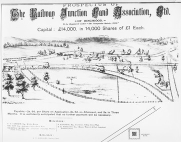 Ringwood and District Historical Society
Document, Land sale prospectus - Railway Junction Land Association Ltd., Ringwood - circa 1890
... Not to scale but largely true to life of approximately 1890. Many local landmarks shown e.g. Wesleyan Chapel, Duncans Antimony Mine Hotel, Cass's School, Herry's Store. ...Not to scale but largely true to life of approximately 1890. Many local landmarks shown e.g. Wesleyan Chapel, Duncans Antimony Mine Hotel, Cass's School, Herry's Store. ...Black and white copy of Prospectus documentEarly Sketch of Ringwood Layout (part). Not to scale but largely true to life of approximately 1890. Many local landmarks shown e.g. Wesleyan Chapel, Duncans Antimony Mine Hotel, Cass's School, Herry's Store. Maroondah Highway not shown but would approximate a line drawn from just to left of horse and cart near Chapel - North to pass around Antimony Mine and to the left to pass behind Cass's School.' -
 Greensborough Historical Society
Photograph - Digital image, Marilyn Smith, Horseland Greensborough 2, 18/08/2015
... The Horseland store at 87 Main Street Greensborough was a local landmark with its model of a horse on the verandah roof. ...Greensborough Historical Society 34A Glenauburn Road Lower Plenty Lower Plenty melbourne The Horseland store at 87 Main Street Greensborough was a local landmark with its model of a horse on the verandah roof. ...The Horseland store at 87 Main Street Greensborough was a local landmark with its model of a horse on the verandah roof. This store closed late in 2015. This view shows the store within the streetscape and was taken from the opposite side of Main Street.The Horseland store was a symbol of Greensborough's past as a country town.Digital copy of colour photographhorseland greensborough, main street greensborough -
 Rutherglen Historical Society
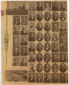
Image, c1880-1890
... Photographs of each individual are identified with their name below the image. Photos of local landmarks are at each corner: top left - Great Southern Mine, top right - Town Hall, bottom left - Main Street-Looking West, bottom right - Main Street-Looking East....Photographs of each individual are identified with their name below the image. Photos of local landmarks are at each corner: top left - Great Southern Mine, top right - Town Hall, bottom left - Main Street-Looking West, bottom right - Main Street-Looking East. ...Copy of a photograph of early pioneers of Rutherglen. Copy has been made in two sections. The original featured a bunch of grapes in the centre with individual photographs, grouped about the centre. Photographs of each individual are identified with their name below the image. Photos of local landmarks are at each corner: top left - Great Southern Mine, top right - Town Hall, bottom left - Main Street-Looking West, bottom right - Main Street-Looking East.rutherglen, rutherglen pioneers -
 Kew Historical Society Inc
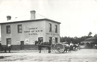
Photograph, Harp of Erin Hotel, c.1880
... The ‘Harp’ was a local landmark, used by the Melbourne Hunt Club for their meetings. ...The ‘Harp’ was a local landmark, used by the Melbourne Hunt Club for their meetings. ...This work forms part of the collection assembled by the historian Dorothy Rogers, that was donated to the Kew Historical Society by her son John Rogers in 2015. The manuscripts, photographs, maps, and documents were sourced by her from both family and local collections or produced as references for her print publications. Many were directly used by Rogers in writing ‘Lovely Old Homes of Kew’ (1961) and 'A History of Kew' (1973), or the numerous articles on local history that she produced for suburban newspapers. Most of the photographs in the collection include detailed annotations in her hand. The Rogers Collection provides a comprehensive insight into the working habits of a historian in the 1960s and 1970s. Together it forms the largest privately-donated collection within the archives of the Kew Historical Society.Harp of Erin (c.1864-1956). Strategically situated on Bulleen Road (High Street) in East Kew, the ‘Harp of Erin’ was built on the corner of Harp Road and High Street. The present hotel is the third to be built on the site. A second, two storey brick and stucco hotel built c.1864 replaced an earlier wooden structure built in 1854 by Edward Glynn. The ‘Harp’ was a local landmark, used by the Melbourne Hunt Club for their meetings. The Club had their kennels behind the hotel, and at meets, red-coated riders might be seen assembling from all directions. The later building was constructed in 1956."Harp of Erin Hotel. Has been altered several times. First built by Edw. Glynn 1851. Not the first which was built in 1854."harp of erin hotel, dorothy rogers -
 Kew Historical Society Inc
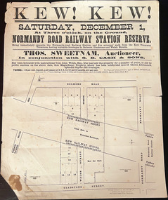
Plan, Kew! Kew!, 1888
... On the plan, local landmarks such as the tram terminus, the Harp of Erin hotel, and the station are located. ...On the plan, local landmarks such as the tram terminus, the Harp of Erin hotel, and the station are located. ...The Land Boom of the 1880s accelerated the rate of subdivisions in Kew. This subdivision, 'Kew! Kew!' was also impacted by, or resulted from, the decision by the Victorian Government to construct the Outer Circle railway. Construction of the railway began in 1888 and was completed in 1891. Plan of an 1888 subdivision bounded by Bulleen Road (now High Street), Gladstone Street (now Campbell Street?), Park Street (now Adeney Avenue), and Belmore Road (now Harp Road). The 16 lots in the proposed subdivision are bisected by the route of the Outer Circle railway, and next to the proposed Normanby Station (later renamed East Kew). On the plan, local landmarks such as the tram terminus, the Harp of Erin hotel, and the station are located. The street where the lots are numbered , was called Welsh Street on the plan as this was the name of the vendor. Surrounding land owners are also named: G. Smith Esq, Matthew Maher Esq, and Maurice Neligan Esq.outer circle railway, land subdivisions -
 Warrnambool and District Historical Society Inc.
33.3 R.P.M. Record (Warrnambool Technical School), H.M.S. Pinafore, 1971
... This business used a local landmark, the Tower Hill State Park, as its logo and label. ...This business used a local landmark, the Tower Hill State Park, as its logo and label. ...This record was made by a local business existing in the 1960s and early 70s, Warrnambool Recording Enterprises. This business used a local landmark, the Tower Hill State Park, as its logo and label. The recording is of the 1971 production of ‘H.M.S. Pinafore’ by the students of Warrnambool Technical College. This school was established in 1913 in Timor Street and in 1973, as Warrnambool Technical School, was relocated to Caramut Road and re-named Brauer college in 1990. The Timor Street site is now the South West TAFE College. This record is of interest as a memento both of the Warrnambool Technical College’s musical performance in 1971 and of the production of records such as this one by a local business, Warrnambool Recording Enterprises in the early 1970s. This is a 33.3 R.P.M. record with a part-image of a guitar and a yellow label in the centre with black printing and typing. It is in a paper sleeve which is tattered with the bottom section mostly missing. The cover does not appear to belong to the record. Tower Hill HMS Pinafore presented by students of Warrnambool Technical School 1971 Custom Recording by Warrnambool Recording Enterprises P.O. Box 123 Warrnambool Phone 8223warrnambool technical school, warrnambool recording enterprises tower hill label, history of warrnambool, ‘h.m.s. pinafore’ -
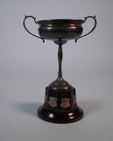 Bendigo Historical Society Inc.
Award - SILVER PLATED TROPHY
... The café was a local landmark, famous for its jukebox, thick shakes, and a giant neon rabbit sign Billiards Connection: Bob Rechter was himself a noted "100 break" player in Bendigo's billiards history. ...The café was a local landmark, famous for its jukebox, thick shakes, and a giant neon rabbit sign Billiards Connection: Bob Rechter was himself a noted "100 break" player in Bendigo's billiards history. ...Rechters Café was located in Mitchell Street, Bendigo, operating for 50 years until it closed in 1996 following the passing of owner Bob Rechter. The café was a local landmark, famous for its jukebox, thick shakes, and a giant neon rabbit sign Billiards Connection: Bob Rechter was himself a noted "100 break" player in Bendigo's billiards history. The Rechters Café - Inter city perpetual trophy is a silver-plated physical award that was historically contested in B grade billiards between the cities of Bendigo and Ballarat.Silver plated trophy. Inscribed at the top: Rechters Café - Inter City Perpetual Trophy - B grade billiards - Bendigo Ballarat. All around the base 8 shields.trophies & awards, sports, billiard -
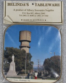 Wodonga & District Historical Society Inc
Memorabilia - Souvenir Coaster Woodland Grove Wodonga, Albury Souvenir Supplies, C. 1980s
... A range of souvenirs depicting local landmarks were produced to represent and promote Wodonga and other towns throughout much of the 20th century. ...Wodonga & District Historical Society Inc Hut 97, Bonegilla Migrant Experience, 132 Bonegilla Road Bonegilla the-murray A range of souvenirs depicting local landmarks were produced to represent and promote Wodonga and other towns throughout much of the 20th century. ...A range of souvenirs depicting local landmarks were produced to represent and promote Wodonga and other towns throughout much of the 20th century. THE WATER TOWER is a major landmark of High Street, Wodonga. It began operation from 1924 until it ceased operation in 1959. It stood unused for a decade until the lower section was modified and put to use as “The Tower’s Cobbler’s Inn” in 1962. In 1972 Wodonga City Council proposed to demolish the Tower. Their suggestion received an unfavorable response from the city’s citizens, so the Tower still stands today. THE SOLDIERS' MEMORIAL in Wodonga was unveiled on Tuesday 18th November 1924. The soldier statue on the top has since been removed and placed in the RSL rooms, WodongaAn unopened packet containing a souvenir drink coaster representing Wodonga, Victoria. The coaster is a coloured photo of the Water Tower and Soldiers' Memorial in High Street, Wodonga.Beneath the photo "WATER TOWER, WODONGA, VICsouvenirs wodonga, water tower, memorials, woodland grove -
 Wodonga & District Historical Society Inc
Functional object - Radio Transceiver
... He lived in Leonard Street, Wodonga for over 40 years, and the antennas that rose from the back yard were a local landmark. He passed away in 2010, a proud Wodonga resident and keen "Ham" to the end....He lived in Leonard Street, Wodonga for over 40 years, and the antennas that rose from the back yard were a local landmark. He passed away in 2010, a proud Wodonga resident and keen "Ham" to the end. ...This transceiver was made by Merv Collins, a long-time resident of Wodonga. His call sign VK3AF) is attached to both of the radios. "Merv" Mervyn Aubrey Lascelles Collins was born near Horsham Victoria in 1922. He and his family moved to Wodonga in 1965 so that he could work at the newly opened TV transmission station at Mt Baranduda, to Wodonga's south. He was passionate about electronics and radio, becoming an Amateur Radio (Ham) operator in the 1950s. He had an amazing understanding of the science, allowing him to build the majority of his equipment from scratch, often without a circuit diagram. Through his resourcefulness, Merv frequently modified old black and white TV's and other equipment destined for landfill, incorporating them into gear ranging from transceivers to test equipment. Merv’s handiwork allowed him to talk to people all around the world. He lived in Leonard Street, Wodonga for over 40 years, and the antennas that rose from the back yard were a local landmark. He passed away in 2010, a proud Wodonga resident and keen "Ham" to the end.This item is significant because it was owned by a local resident who operated it in Wodonga for over 40 years.Two radio transmitters used by a ham radio operator in Wodonga.merv collins wodonga, ham radio transceiver, amateur radio, radio communications -
 Bendigo Historical Society Inc.
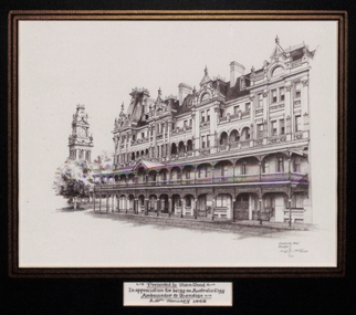
Drawing - Print of Shamrock Hotel, Bendigo, Keith Ross, 1998
... Keith William Ross (19th December 1938 - 22nd May 2025) Local artist Keith Ross was well known for his work that featured local architecture and regional landmarks....Keith William Ross (19th December 1938 - 22nd May 2025) Local artist Keith Ross was well known for his work that featured local architecture and regional landmarks. Shamrock Hotel Keith Ross Ink drawing 'Shamrock Hotel, Bendigo, Keith Ross '95' 'Presented to John Wood in appreciation for being an Australia Day Ambassador to Bendigo, 26th January 1998' Black and white original drawing of the Shamrock Hotel, Bendigo, in a black and gold frame with green card backing. ...Keith William Ross (19th December 1938 - 22nd May 2025) Local artist Keith Ross was well known for his work that featured local architecture and regional landmarks.Black and white original drawing of the Shamrock Hotel, Bendigo, in a black and gold frame with green card backing. Produced on cream coloured paper with black ink. There are notes on the back of the framed print about the Shamrock Hotel, the artist, Keith Ross and its manufacture.'Shamrock Hotel, Bendigo, Keith Ross '95' 'Presented to John Wood in appreciation for being an Australia Day Ambassador to Bendigo, 26th January 1998'shamrock hotel, keith ross, ink drawing -
 Wodonga & District Historical Society Inc
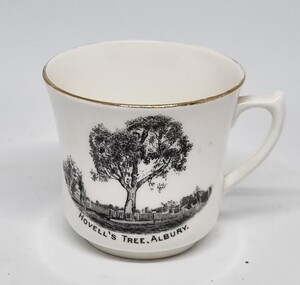
Souvenir - Cup Hovell's Tree, Albury
... This souvenir represents the Hovell Tree, a local historic landmark in Albury, NSW. This item is from a collection donated by descendants of John Francis Turner of Wodonga. ...Wodonga & District Historical Society Inc Hut 97, Bonegilla Migrant Experience, 132 Bonegilla Road Bonegilla the-murray This souvenir represents the Hovell Tree, a local historic landmark in Albury, NSW. This item is from a collection donated by descendants of John Francis Turner of Wodonga. ...This souvenir represents the Hovell Tree, a local historic landmark in Albury, NSW. This item is from a collection donated by descendants of John Francis Turner of Wodonga. The Hovell Tree commemorates the exploration and naming of the Hume River (now the Murray) by Hume and Hovell`s expedition of 1824. In 1824, Governor Brisbane asked Hume to join forces with an English sea captain, William Hovell, to go from Lake George to the Spencer Gulf in South Australia. The Hovell Tree, marked by William Hovell on November 17, 1824 was flanked by another tree marked by Hamilton Hume which was destroyed by fire in the 1840's. The river gum was marked by William Hovell when discovering river. Hume and Hovell travelled from the Yass area and after crossing the Murray River where Lake Hume now is, they crossed the Mitta Mitta River and proceeded to Corio Bay, Westernport.This item is representative of souvenirs produced to represent key buildings and historic landmarks in the Albury-Wodonga district.A white cup with gilt trim around the lip. It bears an image of the Hovell Tree in Albury, NSWBeneath image: "HOVELL'S TREE, ALBURY."albury souvenirs, hovell tree, hume and hovell, australian exploration -
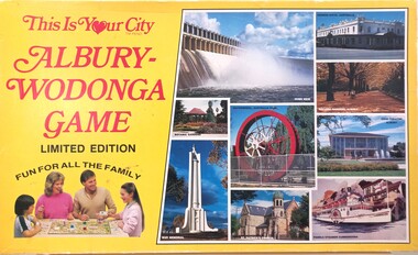 Wodonga & District Historical Society Inc
Leisure object - Albury - Wodonga Board Game, This is Your City, E-System Publications, 1986
... Cards in the game featured local businesses and landmarks. ...Cards in the game featured local businesses and landmarks. This item is significant because it was an alternate way to market the Albury- Wodonga region in the 1980s. ...This was one of several games in a series which focused on Regional Cities within NSW and Victoria, Australia. Their main function was to promote regions and businesses within the cities featured in each game. The gameboard is a full colour representation of each city and the players competed with each other to race to targeted destinations on the gameboard. The first player to arrive at the targeted destination bought that property and received a destination card. The first player to purchase 10 destination cards and return home safely, won the game. Cards in the game featured local businesses and landmarks. This item is significant because it was an alternate way to market the Albury- Wodonga region in the 1980s.A board game including a coloured board featuring locations in Albury - Wodonga. The board has a green background with streets and buildings in various colours. The box is half in bright yellow and features an image of family playing the game. The rest of the box features 9 images of locations in the area.On the box: This is your City Albury - Wodonga Game Limited Edition FUN FOR ALL THE FAMILYalbury - wodonga game, leisure activities albury wodonga, albury-wodonga marketing -
 Ballarat Heritage Services
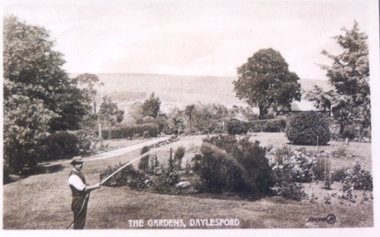
Photograph - Postcard, Wombat Hill Gardens, Daylesford
... As the most prominent local landmark, the Garden’s vertical dominance in the landscape provides a dark contrast to the elms avenues, oaks and other deciduous species. ...As the most prominent local landmark, the Garden’s vertical dominance in the landscape provides a dark contrast to the elms avenues, oaks and other deciduous species. ...The Daylesford Botanic Gardens are of historic, scientific (botanic), and aesthetic significance to the State of Victoria. The Daylesford Botanic Gardens are historically significant as a fine example of a regional botanic garden demonstrating the typical characteristics of a carriage drive, informal park layout, decorative structures and works such as the memorial tower, conservatory, rotunda, cascade and fernery, which contrasts with the open lawns planted with specimen trees, areas of intensive horticultural interest and close proximity to a township developed during the mid to late nineteenth century. The Daylesford Botanic Gardens are historically significant for the design input by noted landscape designer William Sangster, and for the survival of his 1884 plan, which is a rare example of a plan from this prolific garden designer. The Daylesford Botanic Gardens are of scientific (botanic) significance for the extensive conifer collection and cool climate plants. The Gardens contain an outstanding collection of conifers and other mature trees, many of which were donated by renowned botanist Ferdinand von Mueller. Significant trees include Pinus ponderosa (Western Yellow Pine), Pinus coulteri (Big Cone Pine), twoAbies nordmanniana (Caucasian Fir), Abies pinsapo, (Spanish Fir) and a Cedrus atlantica f. glauca(Blue Atlas Cedar), Pinus wallichiana (Bhutan Pine), Pinus pinaster (Maritime Pine), Sequoiadendron giganteum (Giant Redwood), (Monkey Puzzle) and Aesculus hippocastanum (Horse Chestnut), many the largest or finest examples in Victoria. Other outstanding trees include a Tilia cordata (Small-leaved European Linden), a row of Cupressus lusitanica (Mexican cypress), a Quercus robur (English Oak) planted in 1863, avenues of Dutch Elms and a rare Quercus leucotrichophora (Himalayan Oak). The Daylesford Botanic Gardens are of aesthetic significance as a rare example of a botanic garden spectacularly sited on an extinct volcanic cone which allows a panoramic view, aided by the 1938 Pioneers’ Memorial Tower, as well as vistas within and out of the gardens and from the township to the gardens. As the most prominent local landmark, the Garden’s vertical dominance in the landscape provides a dark contrast to the elms avenues, oaks and other deciduous species. (Heritage Victoria Register, )Black and white postcard of Wombat Hill Botanical Gardens, Daylesford.wombat hill botanical gardens, daylesford, gardener, wombat hill botanic gardens -
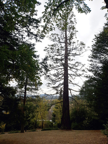
 Ballarat Heritage Services
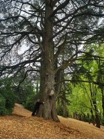
Photograph - Photograph - Colour, Clare Gervasoni, Wombat Botanic Gardens, Daylesford, 2019, 23/04/2019
... As the most prominent local landmark, the Garden’s vertical dominance in the landscape provides a dark contrast to the elms avenues, oaks and other deciduous species. ...As the most prominent local landmark, the Garden’s vertical dominance in the landscape provides a dark contrast to the elms avenues, oaks and other deciduous species. ...The Daylesford Botanic Gardens are of historic, scientific (botanic), and aesthetic significance to the State of Victoria. The Daylesford Botanic Gardens are historically significant as a fine example of a regional botanic garden demonstrating the typical characteristics of a carriage drive, informal park layout, decorative structures and works such as the memorial tower, conservatory, rotunda, cascade and fernery, which contrasts with the open lawns planted with specimen trees, areas of intensive horticultural interest and close proximity to a township developed during the mid to late nineteenth century. The Daylesford Botanic Gardens are historically significant for the design input by noted landscape designer William Sangster, and for the survival of his 1884 plan, which is a rare example of a plan from this prolific garden designer. The Daylesford Botanic Gardens are of scientific (botanic) significance for the extensive conifer collection and cool climate plants. The Gardens contain an outstanding collection of conifers and other mature trees, many of which were donated by renowned botanist Ferdinand von Mueller. Significant trees include Pinus ponderosa (Western Yellow Pine), Pinus coulteri (Big Cone Pine), twoAbies nordmanniana (Caucasian Fir), Abies pinsapo, (Spanish Fir) and a Cedrus atlantica f. glauca(Blue Atlas Cedar), Pinus wallichiana (Bhutan Pine), Pinus pinaster (Maritime Pine), Sequoiadendron giganteum (Giant Redwood), (Monkey Puzzle) and Aesculus hippocastanum (Horse Chestnut), many the largest or finest examples in Victoria. Other outstanding trees include a Tilia cordata (Small-leaved European Linden), a row of Cupressus lusitanica (Mexican cypress), a Quercus robur (English Oak) planted in 1863, avenues of Dutch Elms and a rare Quercus leucotrichophora (Himalayan Oak). The Daylesford Botanic Gardens are of aesthetic significance as a rare example of a botanic garden spectacularly sited on an extinct volcanic cone which allows a panoramic view, aided by the 1938 Pioneers’ Memorial Tower, as well as vistas within and out of the gardens and from the township to the gardens. As the most prominent local landmark, the Garden’s vertical dominance in the landscape provides a dark contrast to the elms avenues, oaks and other deciduous species. (Heritage Victoria Register, 2025)A large tree in the Wombat Gardens. wombat botanical gardens, daylesford botanical gardens, daylesford, trees, lisa gervasoni, wombat botanic gardens -
 Ballarat Heritage Services
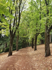
Photograph - Photograph - Colour, Clare Gervasoni, Wombat Botanic Gardens, Daylesford, 2019, 23/04/2019
... As the most prominent local landmark, the Garden’s vertical dominance in the landscape provides a dark contrast to the elms avenues, oaks and other deciduous species. ...As the most prominent local landmark, the Garden’s vertical dominance in the landscape provides a dark contrast to the elms avenues, oaks and other deciduous species. ...The Daylesford Botanic Gardens are of historic, scientific (botanic), and aesthetic significance to the State of Victoria. The Daylesford Botanic Gardens are historically significant as a fine example of a regional botanic garden demonstrating the typical characteristics of a carriage drive, informal park layout, decorative structures and works such as the memorial tower, conservatory, rotunda, cascade and fernery, which contrasts with the open lawns planted with specimen trees, areas of intensive horticultural interest and close proximity to a township developed during the mid to late nineteenth century. The Daylesford Botanic Gardens are historically significant for the design input by noted landscape designer William Sangster, and for the survival of his 1884 plan, which is a rare example of a plan from this prolific garden designer. The Daylesford Botanic Gardens are of scientific (botanic) significance for the extensive conifer collection and cool climate plants. The Gardens contain an outstanding collection of conifers and other mature trees, many of which were donated by renowned botanist Ferdinand von Mueller. Significant trees include Pinus ponderosa (Western Yellow Pine), Pinus coulteri (Big Cone Pine), twoAbies nordmanniana (Caucasian Fir), Abies pinsapo, (Spanish Fir) and a Cedrus atlantica f. glauca(Blue Atlas Cedar), Pinus wallichiana (Bhutan Pine), Pinus pinaster (Maritime Pine), Sequoiadendron giganteum (Giant Redwood), (Monkey Puzzle) and Aesculus hippocastanum (Horse Chestnut), many the largest or finest examples in Victoria. Other outstanding trees include a Tilia cordata (Small-leaved European Linden), a row of Cupressus lusitanica (Mexican cypress), a Quercus robur (English Oak) planted in 1863, avenues of Dutch Elms and a rare Quercus leucotrichophora (Himalayan Oak). The Daylesford Botanic Gardens are of aesthetic significance as a rare example of a botanic garden spectacularly sited on an extinct volcanic cone which allows a panoramic view, aided by the 1938 Pioneers’ Memorial Tower, as well as vistas within and out of the gardens and from the township to the gardens. As the most prominent local landmark, the Garden’s vertical dominance in the landscape provides a dark contrast to the elms avenues, oaks and other deciduous species. (Heritage Victoria Register, 2025)An avenue of trees in the Wombat Hill Gardens. wombat botanical gardens, daylesford botanical gardens, daylesford, trees -
 Ballarat Heritage Services
Photograph - Photograph - Colour, Clare Gervasoni, Wombat Botanic Gardens, Daylesford, 2019, 23/04/2019
... As the most prominent local landmark, the Garden’s vertical dominance in the landscape provides a dark contrast to the elms avenues, oaks and other deciduous species. ...As the most prominent local landmark, the Garden’s vertical dominance in the landscape provides a dark contrast to the elms avenues, oaks and other deciduous species. ...The Daylesford Botanic Gardens are of historic, scientific (botanic), and aesthetic significance to the State of Victoria. The Daylesford Botanic Gardens are historically significant as a fine example of a regional botanic garden demonstrating the typical characteristics of a carriage drive, informal park layout, decorative structures and works such as the memorial tower, conservatory, rotunda, cascade and fernery, which contrasts with the open lawns planted with specimen trees, areas of intensive horticultural interest and close proximity to a township developed during the mid to late nineteenth century. The Daylesford Botanic Gardens are historically significant for the design input by noted landscape designer William Sangster, and for the survival of his 1884 plan, which is a rare example of a plan from this prolific garden designer. The Daylesford Botanic Gardens are of scientific (botanic) significance for the extensive conifer collection and cool climate plants. The Gardens contain an outstanding collection of conifers and other mature trees, many of which were donated by renowned botanist Ferdinand von Mueller. Significant trees include Pinus ponderosa (Western Yellow Pine), Pinus coulteri (Big Cone Pine), twoAbies nordmanniana (Caucasian Fir), Abies pinsapo, (Spanish Fir) and a Cedrus atlantica f. glauca(Blue Atlas Cedar), Pinus wallichiana (Bhutan Pine), Pinus pinaster (Maritime Pine), Sequoiadendron giganteum (Giant Redwood), (Monkey Puzzle) and Aesculus hippocastanum (Horse Chestnut), many the largest or finest examples in Victoria. Other outstanding trees include a Tilia cordata (Small-leaved European Linden), a row of Cupressus lusitanica (Mexican cypress), a Quercus robur (English Oak) planted in 1863, avenues of Dutch Elms and a rare Quercus leucotrichophora (Himalayan Oak). The Daylesford Botanic Gardens are of aesthetic significance as a rare example of a botanic garden spectacularly sited on an extinct volcanic cone which allows a panoramic view, aided by the 1938 Pioneers’ Memorial Tower, as well as vistas within and out of the gardens and from the township to the gardens. As the most prominent local landmark, the Garden’s vertical dominance in the landscape provides a dark contrast to the elms avenues, oaks and other deciduous species. (Heritage Victoria Register, )A tree in the Wombat Hill Gardens.wombat botanical gardens, daylesford botanical gardens, daylesford, trees, wombat hill botanic gardens