Showing 717 items matching "local water"
-
 Charlton Golden Grains Museum Inc
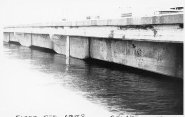
Photograph, Charlton Tribune, B/W Photograph of 1973 Flooded Avoca River, February 1973
... ...Local Water...Water Level 25ft 1 1/2 inches - all local water...Water Level 25ft 1 1/2 inches - all local water...Water Level 25ft 1 1/2 inches - all local water James Paterson Bridge Local Water Floods Charlton unframed 1973 Flooded Avoca River in Charlton Victoria at the Paterson Bridge. ...1973 Flooded Avoca River in Charlton Victoria at the Paterson Bridge. Water Level 25ft 1 1/2 inches - all local waterunframed 1973 Flooded Avoca River in Charlton Victoria at the Paterson Bridge. Water Level 25ft 1 1/2 inches - all local waterjames paterson bridge, local water, floods, charlton -
 Whitehorse Historical Society Inc.
Letter - Correspondence, Australia Day Family Festival, 1994
... Sketched by Joy Brentwood, local water colour artist....Sketched by Joy Brentwood, local water colour artist. Australia Day Family Festival Letter Correspondence ...Envelope with coloured illustration for Australia Day Family Festival January 1994. Sketched by Joy Brentwood, local water colour artist.Envelope with coloured illustration for Australia Day Family Festival January 1994. Sketched by Joy Brentwood, local water colour artist.Envelope with coloured illustration for Australia Day Family Festival January 1994. Sketched by Joy Brentwood, local water colour artist.local government, city of nunawading, brentwood, joy, festivals and celebrations, australia day -
Tatura Irrigation & Wartime Camps Museum
Folder, Recollections of Eildon
... local history...water...Also contains 50 slide power point disc. local history water irrigation books history local rural industry Blue plastic cover. ...Recollections of construction of Eildon Dam and life in the township. Also contains 50 slide power point disc.Blue plastic cover. Black spine. White label- handwritten titlelocal history, water, irrigation, books, history, local, rural, industry -
 Clunes Museum
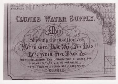
Document - MAP
... local history...photographs...water...FOR THE COLLECTION AND DISTRIBUTION OF WATER FOR DOMESTIC AND MINING PURPOSES TO THE TOWN OF & GOLDMINES IN AND AROUND CLUNES. local history photographs water supply SEE PHOTOGRAPH ON BACK OF HISTORY OF OBJECT. ...CLUNES WATER SHED SUPPLY MAP SHEWING THE POSITION OF WATERSHED ECT. FOR THE COLLECTION AND DISTRIBUTION OF WATER FOR DOMESTIC AND MINING PURPOSES TO THE TOWN OF & GOLDMINES IN AND AROUND CLUNES.PHOTOCOPY SECTION OF PHOTOGRAPH AND PLAQUE AND MAP OF CLUNES WATER SUPPLY. SHOWING THE POSITION OF WATERSHED, DAM, WEIR PIPEHEAD RESERVOIR PIPE TRACK.SEE PHOTOGRAPH ON BACK OF HISTORY OF OBJECT.local history, photographs, water supply -
 Clunes Museum
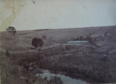
Photograph
... local history...photographs...water...Clunes Museum 36 Fraser Street enter building through Collins Place Clunes goldfields ORIGINAL WATER SUPPLY FOR CLUNES VIA BIRCH'S CREEK, BEFORE PIPES WERE LAID. local history photographs water supply SEPIA PHOTOGRAPH OF WEIR ON BIRCH CREEK - CLUNES WATER SUPPLY. ...ORIGINAL WATER SUPPLY FOR CLUNES VIA BIRCH'S CREEK, BEFORE PIPES WERE LAID.SEPIA PHOTOGRAPH OF WEIR ON BIRCH CREEK - CLUNES WATER SUPPLY. PICKET FENCES SURROUNDING AREA. ONE MAN STANDING BY POND. TUSSOCKS BESIDE WATER. A HOUSE IN RIGHT HAND UPPER CORNER.local history, photographs, water supply -
Clunes Museum
Document - WATER SUPPLY REPORT
... LOCAL HISTORY...DOCUMENTS...WATER...Clunes Museum 36 Fraser Street enter building through Collins Place Clunes goldfields LOCAL HISTORY DOCUMENTS WATER SUPPLY 1.2 X REPORTS AND MINUTES RE WATER SUPPLY COMMITTEE FORMED 1869 3. ...1.2 X REPORTS AND MINUTES RE WATER SUPPLY COMMITTEE FORMED 1869 3. SUPPLEMENTAL EVIDENCE 16.2.1845 RE GOLD DISCOVERIESlocal history, documents, water supply -
Clunes Museum
Newspaper - NEWSPAPERS
... LOCAL HISTORY...NEWSPAPERS...WATER...Clunes Museum 36 Fraser Street enter building through Collins Place Clunes goldfields LOCAL HISTORY NEWSPAPERS WATER SUPPLY NEWSPAPERS FROM 1974 AND 1975 CLUNES WATER SUPPLY, LONE PINE TREE, MECHANICS INSTITUTE Newspaper NEWSPAPERS ...NEWSPAPERS FROM 1974 AND 1975 CLUNES WATER SUPPLY, LONE PINE TREE, MECHANICS INSTITUTElocal history, newspapers, water supply -
Clunes Museum
Domestic object - HOT WATER BOTTLE COVER, APPROX 1920
... local history...HOT WATER...Clunes Museum 36 Fraser Street enter building through Collins Place Clunes goldfields local history HOT WATER BOTTLE COVER W HULL WHITE LINEN EMBROIDERED HOT WATER BOTTLE COVER,SCALLOPED EDGE, DRAW STRING COTTON TAPE Domestic object HOT WATER BOTTLE COVER ...WHITE LINEN EMBROIDERED HOT WATER BOTTLE COVER,SCALLOPED EDGE, DRAW STRING COTTON TAPEW HULLlocal history, hot water bottle cover -
Clunes Museum
Book, DRAWINGS & DESCRIPTION OF CLUNES WATER WORKS VICTORIA, 1875
... LOCAL HISTORY...CLUNES...WATER...Clunes Museum 36 Fraser Street enter building through Collins Place Clunes goldfields LOCAL HISTORY CLUNES WATER WORKS DRAWINGS LARGE BOOK DATED 1875. ...LARGE BOOK DATED 1875. DRAWINGS AND DESCRIPTIONS OF CLUNES WATERWORKS. CONTAINS 12 PAGESlocal history, clunes, water works, drawings -
 Clunes Museum
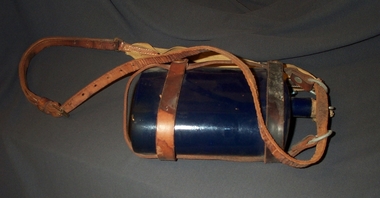
Container - BOTTLE
... local history...military...water...Clunes Museum 36 Fraser Street enter building through Collins Place Clunes goldfields local history military water bottle army RIDER & BELL .1 BLUE ENAMEL DRINK BOTTLE .2 CORK HAS METAL TOP WITH EYE. ....1 BLUE ENAMEL DRINK BOTTLE .2 CORK HAS METAL TOP WITH EYE. STRING THREADED THROUGH EYE.RIDER & BELLlocal history, military, water bottle, army -
 Sunbury Family History and Heritage Society Inc.
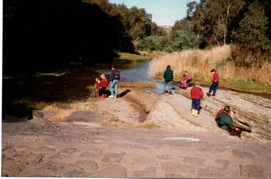
Photograph, River studies
... Students from Bulla Primary school were taken to the nearby Deep Creek to study some of the river life inn the local water course....Sunbury Global Learning Centre Macedon Street Sunbury melbourne Students from Bulla Primary school were taken to the nearby Deep Creek to study some of the river life inn the local water course. Bulla township is situated in the Deep Creek valley and was an ideal place to take students to study river life close to their school. ...Students from Bulla Primary school were taken to the nearby Deep Creek to study some of the river life inn the local water course.Bulla township is situated in the Deep Creek valley and was an ideal place to take students to study river life close to their school.A coloured photograph of eight children with two adults standing on a rocky outcrop beside a river and looking at the riverlife in the water.rivers, deep creek, river studies, bulla, bulla primary school -
 Beaconhills College
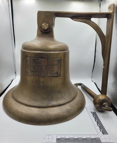
Functional object - School Bell, 1982
... The school bell was donated in February 1982 to Beaconhills College by Errol Robinson (1916-1989) chairman of the local water board. Mr Robinson was the father-in-law of one of the school parents - Mr Ted Fankhauser who was later to be the school's first Business Administrator. ...The brass bell, gifted to Beaconhills College in February 1982 by local Water Board chairman Errol Robinson, is a cherished symbol of the College’s formative years. ...The school bell was donated in February 1982 to Beaconhills College by Errol Robinson (1916-1989) chairman of the local water board. Mr Robinson was the father-in-law of one of the school parents - Mr Ted Fankhauser who was later to be the school's first Business Administrator. The bell was dedicated at the school's annual church service. The dedication was made by Archbishop Sir Frank Woods on 28 March 1982. The bell is no longer in use but serves as a symbol of the founding years of the college. Note there has been some discussion about the original donation date actually occurring in 1983 - this is being investigated.The brass bell, gifted to Beaconhills College in February 1982 by local Water Board chairman Errol Robinson, is a cherished symbol of the College’s formative years. Its donation—facilitated through family ties within the school community—reflects the deep spirit of collaboration and support that defined the early culture of Beaconhills. The bell was formally dedicated by Archbishop Sir Frank Woods at the school’s annual church service on 28 March 1982. Though it is no longer rung, the bell serves as a powerful emblem of tradition and identity, marking a time of growth, faith, and communal vision. Today, it stands not as a functional tool, but as a resonant echo of the College’s beginnings—honouring the people, values, and moments that shaped its foundation. Complete brass bell with brass tongue. Large. Inscription plate on the front. Brass bracket attached to the top of the bell with a brass hexagonal nut and bolt also brass.Presented to Beaconhills Christian College by EG Robinson Dedicated on the 28th March 1982 by Archbishop Sir Frank Woods -
 Bendigo Historical Society Inc.
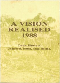
Book - "A Vision Realised. 1988. District History of Underbool, Torrita, Linga, and Boinka.", 1988
... Discusses aspects affecting locals, including the local Shire, Water supply, the Railway, Roads, Farming, Salt, Businesses, Sporting Clubs, and School. ...Discusses aspects affecting locals, including the local Shire, Water supply, the Railway, Roads, Farming, Salt, Businesses, Sporting Clubs, and School. ...John Henry Lockett OAM (22 January 1891 – 25 May 2002) was the oldest man ever in Australia when he died aged 111 years, 123 days. As one of the last surviving veterans of World War I, he was acclaimed as a national hero during the last decade of his life. Lockett was born in the small Victorian town of Waanyarra, near Bendigo. He left school aged nine to work on a local farm. Later, he worked for his uncles in the Mallee. On 24 March 1916, he travelled to Mildura to enlist in the Australian Imperial Force. He served in France with the 38th Battalion, earning promotion to sergeant and was discharged on 20 September 1919. https://en.wikipedia.org/wiki/Jack_Lockett After the war, Jack returned to The Mallee and selected a 640 acres (260 ha) block of land in Linga, Victoria, deciding to make his living as a farmer. In 1923, he married Maybell Ingwerson and they had four children together. In 1963, the couple retired to Bendigo in 1953, leaving the farmland (which now covered more than 130,000 acres (53,000 ha), in the care of their children and grandchildren. "A Vision Realised. 1988. District History of Underbool, Torrita, Linga and Boinka" compiled and edited by Janet Lynch, Margaret Willsmore, and Christy Brown. Foreword by Janet Lynch, Margaret Willsmore, and Christy Brown. A history of the Mallee towns of Underbool, Torrita, Linga and Boinka containing a collection of 61 local family histories. Discusses aspects affecting locals, including the local Shire, Water supply, the Railway, Roads, Farming, Salt, Businesses, Sporting Clubs, and School. Published in Australia by Underbool Back To Committee. Printed by Sunnyland Press, Red Cliffs. Soft cover book, with tones of green and tan on cover - back, front and spine. Titles printed in brown. Book includes black and white photographs of locals, and local events. Includes an article on Jack Lockett on Pages 127 and 128. 151 pp.jack lockett, underbool, torrita, linga, boinka -
 Flagstaff Hill Maritime Museum and Village
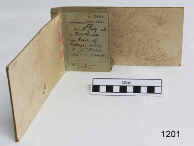
Financial record - Receipt Book, Department of Works and Mines Victoria, July 1936 (first record)
... In 1865 the Waterworks Act gave the Board power to construct waterworks, purchase land, levy charges and lease or sell works, while the Public Loans Act 1865 empowered it to provide loans to local water trusts for waterworks. The actual administration of these statutory provisions was undertaken by the Victorian Water Supply Department which operated from 1865 to 1889 as a sub-department of the Department of Mines, from 1889 as a department in its own right, and from 1895 to 1909 as a sub-department of the Department of Mines and Water Supply. ...In 1865 the Waterworks Act gave the Board power to construct waterworks, purchase land, levy charges and lease or sell works, while the Public Loans Act 1865 empowered it to provide loans to local water trusts for waterworks. The actual administration of these statutory provisions was undertaken by the Victorian Water Supply Department which operated from 1865 to 1889 as a sub-department of the Department of Mines, from 1889 as a department in its own right, and from 1895 to 1909 as a sub-department of the Department of Mines and Water Supply. ...Establishment and Functions Prior to 1860, the Chief Secretary's Department had been responsible for the administration of the gold fields and associated mining activities. In November 1860 a Commissioner of Mines was appointed and a Department was established under his administration. For the period November 1861 to June 1863, the Postmaster General was responsible for the Mining Department. A Minister of Mines was again appointed in 1863. Responsibilities of the Department of Mines were: 1. Regulation of mining and related public works activities through the issue of miners rights, business and residence licences, mining leases, mineral and other prospecting licences 2. Superintendence of the activities of mining surveyors, registrars, wardens and Mining Boards. 3. Investigation of the state's geological structure, mineral wealth and underground water resources 4. Development of the mining industry 5. Supervision of the safe working of mines, machinery and quarries including checking the credential of mine managers, inspectors and operators 6. Regulation of the disposal of sludge and other waste products 7. Administration of the Victorian Mining Accident Relief Fund. Arising from its initial responsibility for the supply of water on the gold fields, the Department became responsible for rural water supply from the mid 1860s. Statutory responsibility for rural water works during this period rested with the Board of Land and Works. In 1865 the Waterworks Act gave the Board power to construct waterworks, purchase land, levy charges and lease or sell works, while the Public Loans Act 1865 empowered it to provide loans to local water trusts for waterworks. The actual administration of these statutory provisions was undertaken by the Victorian Water Supply Department which operated from 1865 to 1889 as a sub-department of the Department of Mines, from 1889 as a department in its own right, and from 1895 to 1909 as a sub-department of the Department of Mines and Water Supply. For a brief period from 1891 to 1893 the Department of Mines was also responsible for forests and, until 1880, for the Schools of Mines subsequently transferred to the Education Department. In 1895 the Department of Mines and the Victorian Water Supply Department were amalgamated to form the Department of Mines and Water Supply. A snapshot into social history around the 1930s when the Department of works and the Mines Departments were still linkedReceipt Book for the Department of Works; Mines. Receipt No 2801 - 3000. 1st receipt Number 2801, "18th July 1936, for Rent of Cottage: 14 days for 2 pounds, 2 shillings. The inscription on the back is signed by J F Condau in 13-3-33Printed on spine "GENERAL RECEIPTS / 15 / 2801 / TO 3000" Printed on each receipt 'DEPARTMENT OF / PUBLIC WORKS. / MINES." Fill in using ink pen "(DATE) 18th July 1936 / (TO) - - - shields' / BEING) Rent of / Cottage: 14 days / (TO) 17th July / @ (symbol for pound) 1-1. p. week / . (symbol for pound) 2:2:-"Inside cover there is some red pencil writing, words and figures unreadable. Handwritten on back cover "Numbers checked / and found corredt / J S Coudou (?) / 13-3-33" One some receipts "Wharfage / S.S. Koonara"flagstaff hill, warrnambool, shipwrecked coast, flagstaff hill maritime museum, maritime museum, shipwreck coast, flagstaff hill maritime village, great ocean road, department of works: mines, receipt book, rent 1936, imperial currency, living costs 1936, department of works, department of mines, j f condou, 1933, 13-3-33 -
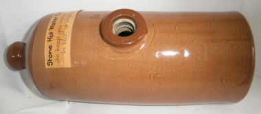 Cheese World Museum
Bottle, Stone hot water bottle
... Neither Ray nor Joyce married and following the death of her brother Joyce set up the Ray and Joyce Uebergang Foundation which supports the local community. This hot water bottle is part of the collection of items given into the care of the Cheese World Museum. ...Neither Ray nor Joyce married and following the death of her brother Joyce set up the Ray and Joyce Uebergang Foundation which supports the local community. This hot water bottle is part of the collection of items given into the care of the Cheese World Museum. ...The Percy Uebergang family lived at Tooram Park, Allansford from 1912 until 1992. Percy and Myrtle Uebergang's children were twins, Ray and Joyce born in 1926 who lived at Tooram Park until their deaths, Ray in 1986 and Joyce in 1992. Neither Ray nor Joyce married and following the death of her brother Joyce set up the Ray and Joyce Uebergang Foundation which supports the local community. This hot water bottle is part of the collection of items given into the care of the Cheese World Museum. Uebergang catalogue No.F61 Brown stoneware cylindrical hot water bottle with dark brown knob at one end used as a handle; a round hole in dark brown on top used to fill the bottle, stopper missing; slightly flattened base to prevent rolling.Uebergang No. F61 (on base) -
 Bendigo Historical Society Inc.
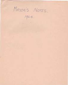
Document - NORMAN OLIVER COLLECTION: MAYOR'S NOTES 1964
... Mayor's Notes 1964, and Contents of File - Mayor's Notes 1964, Bendigo, Local Government, Town Planning, Water - Coliban Area, Business - marketing, etc., Speech for Graduation of Nurses. 2. ...Mayor's Notes 1964, and Contents of File - Mayor's Notes 1964, Bendigo, Local Government, Town Planning, Water - Coliban Area, Business - marketing, etc., Speech for Graduation of Nurses. 2. ...The Norman Oliver collection. Norman Oliver was three times Mayor of Bendigo - 1950-51, 1964-65, 1970-71. 1. Two covering pages, with handwriting in blue pen. Mayor's Notes 1964, and Contents of File - Mayor's Notes 1964, Bendigo, Local Government, Town Planning, Water - Coliban Area, Business - marketing, etc., Speech for Graduation of Nurses. 2. Four typed pages of undated Mayor's Notes which make reference to the first week as Mayor, and learning of his appointment on 29 August. Topics include : a council business meeting dealing with the use of the Garden Gully sports facilities, the Housing Commission garden competition, Royal Commission on supply and consumption of liquor, neighbourhood disputes regarding drainage issues and owner responsibility, Rotary Club slide presentation on Bendigo past and present, tenders to Council for supply of a range of materials, Art Gallery Committee meeting (noting the need for careful selection policy re. donations and borrowings).bendigo, council, speech notes, norman joseph oliver , councillor norman oliver. mayor of bendigo. bendigo art gallery. rotary clubs - bendigo. royal commission on supply and consumption of liquor. -
 Warrnambool and District Historical Society Inc.
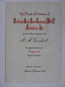
Document, Certificate Mr H Goodall, 1944
... At its peak it employed 600 people and processed 55000 gallons daily in the milk condensery which is a process whereby much of the water content is drawn from the milk and sugar is added making a product which has a long shelf life and because it is processed at low temperature the milk maintains much of its vitamin content. A certificate which links a local ...This certificate was awarded in appreciation of 25 years service to the Nestle Company which operated a dairy factory at Dennington in Warrnambool. The company came to Warrnambool in 1907 and purchased 17 acres at Dennington and a new dairy plant was established by 1911. At its peak it employed 600 people and processed 55000 gallons daily in the milk condensery which is a process whereby much of the water content is drawn from the milk and sugar is added making a product which has a long shelf life and because it is processed at low temperature the milk maintains much of its vitamin content.A certificate which links a local person to a long and well known industry in Warrnambool and the Western district.Cream soft card certificate with red and black text.Mr H Goodall. Nestle and Anglo Swiss Condensed Milk Co Australasia Ltd. dated 1st December 1944. The signature of the Chairman of directors is unreadable.warrnambool, nestle dennington, h goodall -
 Warrnambool and District Historical Society Inc.
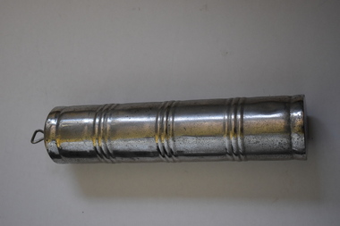
Hot water bottle, 1940s
... Warrnambool and District Historical Society Inc. 2 Gilles Street (south of Merri St) Warrnambool great-ocean-road This is an example of a hot water bottle in common use in households in the mid 20th century before the use of rubber ones. This bottle has no known local provenance but is retained as an example of a household item from the past. 20th century household items early 20th century hotwater bottle SU....... ...This is an example of a hot water bottle in common use in households in the mid 20th century before the use of rubber ones.This bottle has no known local provenance but is retained as an example of a household item from the past. This a cylindrical silver coloured metal canister. It has a screw top stopper with a metal handle. The top of the stopper is rusted. The body of the canister has three lots of ridges around the surface and is also chipped.SU....... Stainless Steel Co. Melb. 20th century household items, early 20th century hotwater bottle -
 Warrnambool and District Historical Society Inc.
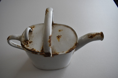
Watering Can, C1900
... This watering can has no known local provenance but is retained as an example of a common household item from early in the 20th century. vintage household items vintage watering can enamel watering can warrnambool ‘Made in England’ This is an oval-shaped enamel watering can. ...This watering can would have been used some decades ago to water pot plants and small plants in the garden requiring individual watering. Today watering cans are still used but mostly they are made of plastic although some cans are made in other materials for decorative reasons. Enamel is a hardy material but it chips when the object is knocked or dropped. This watering can has no known local provenance but is retained as an example of a common household item from early in the 20th century. This is an oval-shaped enamel watering can. It has two handles, a spout and a hinged lid. The can is very rusted. ‘Made in England’vintage household items, vintage watering can, enamel watering can, warrnambool -
 Warrnambool and District Historical Society Inc.
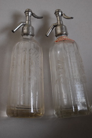
Soda Sypon, John Fletcher/Ralph Reeves, J. F. Fletcher, Mid 20th century (contents of bottles)
... local Warrnambool cordial factory in Koroit Street. Cordial manufacturing was an important industry in Warrnambool for over100 years. Cordial Manufacturing in Warrnambool history of warrnambool ‘J. Fletcher’ “J. Fletcher Trade Mark Warrnambool’ ‘Soda Water ...These two soda syphons were used to dispense soda water. They are marked ‘J. Fletcher’ with one of the bottles having the extra label of ‘Reeves’. The bottles come from the cordial factory in Koroit Street, Warrnambool. John Fletcher worked as a young boy in Rowley’s cordial factory in Banyan Street, Warrnambool and then worked for John Davis who had established the Union Cordial Factory in Koroit Street in the 1860s. John Fletcher bought the Davis business in 1885 and operated this factory until 1930. He then sold to Ralph Reeves who initially used the Fletcher bottles and syphons. At least one of these syphons comes from the Koroit Street factory during the proprietorship of Ralph Reeves.These soda syphons are of interest as they come from a local Warrnambool cordial factory in Koroit Street. Cordial manufacturing was an important industry in Warrnambool for over100 years. These are two soda syphons made of glass with heavy round bases and ridged surfaces on the bottle bodies. The metal tops contain the pump and valve mechanisms and the inside of the bottles have glass tubes attached to the top mechanisms. The sides of the bottle have the Fletcher trade mark symbol of the stylized letters J and F, Both metal tops are corroded. Both bottles contain a small amount of liquid.‘J. Fletcher’ “J. Fletcher Trade Mark Warrnambool’ ‘Soda Water’ ‘This syphon is the property of John Fletcher Warrnambool and cannot be legally used by others’ ‘British Syphon Co. Ltd. London Reg. No 762’. ‘Reeves Soda Water’ (one bottle only) cordial manufacturing in warrnambool, history of warrnambool -
 Warrnambool and District Historical Society Inc.
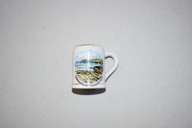
Souvenir, Victoria Fine China, Miniature mug Warrnambool Thunder Point, C 1940
... water baths and partly because of its bracing climate and attractive coastline. Thunder Point, depicted on this item, has been a popular visiting spot for tourists for many years. Buying a high quality ornament such as this one was a popular activity of tourists in the mid 20th century. Tourists today buy souvenir items but the choice and range vary from what was available 80 years ago. This item is retained as an example of a local ...Warrnambool has been an attraction for tourists for over 100 years. It has been popular as a coastal resort and today the winter whale season brings more tourists. In the late 19th and early 20th centuries Warrnambool was promoted as a spa and health resort, partly because of its hot and cold sea water baths and partly because of its bracing climate and attractive coastline. Thunder Point, depicted on this item, has been a popular visiting spot for tourists for many years. Buying a high quality ornament such as this one was a popular activity of tourists in the mid 20th century. Tourists today buy souvenir items but the choice and range vary from what was available 80 years ago. This item is retained as an example of a local souvenir bought by tourists in the mid 20th century. This is a small white china mug with a gilt edging or strip around the top opening rim, the base and the handle. There is a colour image of a seascape in blue, yellow and black on the side of the mug and the maker’s name on the base.‘Victoria Fine China’tourism in warrnambool, souvenir china items 20th century, history of warrnambool -
 Warrnambool and District Historical Society Inc.
Book, Account of works M Black, C 1900
... This ledger has entries which relate to work completed at the time including local names such as Coulsock, Landmann, McFarlane,Redford Allendale, McGennan & Co,Water Works Trust Wm Ardlie....This ledger has entries which relate to work completed at the time including local names such as Coulsock, Landmann, McFarlane,Redford Allendale, McGennan & Co,Water Works Trust Wm Ardlie. ...Alexander Black was a painter and decorator who operated a business in Timor St below Swintons. This ledger has entries which relate to work completed at the time including local names such as Coulsock, Landmann, McFarlane,Redford Allendale, McGennan & Co,Water Works Trust Wm Ardlie.This book lists a number of local names providing local social significance. Local handwritten ledgers such as these were commonly used by many businessesVery worn cardboard cover originally dark blue .with black binding. Rectangular in shape with lined pages. The front pages are filled with names and amounts.Dates range from 28/04/1900 to March 1922: Mr Alex Black Timor Street WarrnamboolLate Black & Eveleigh. White piece of paper has been pasted to front cover..Inside front cover warrnambool, painters and decorators, alex black, alexander black -
 Warrnambool and District Historical Society Inc.
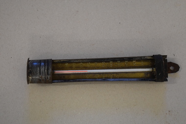
Water temperature reader, Early 20th century
... Water temperature gauges are still in use today. Although this item has no known local provenance it is retained as an example of a household item of the past – a water temperature gauge. ...This temperature gauge would have been used in the past to take the temperature of water in a pot or bath. Water temperature gauges are still in use today. Although this item has no known local provenance it is retained as an example of a household item of the past – a water temperature gauge. This is a glass temperature gauge set into a metal holder with markings on each side of the thermometer. The holder has a metal clip at the top for hanging the object on a wall or cupboard. The holder is much rusted.‘Cold, Cool, Temp, Tepid, Warm, Hot’ ‘351’ bath thermometers, warrnambool, history of warrnambool -
 Warrnambool and District Historical Society Inc.
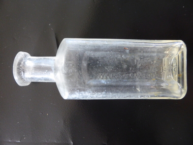
Bottle, H London Chemist & Dentist, Early 20th century
... water to make up his medicines. In his dentistry business he used gas, chloroform and cocaine as anaesthetics. The making of dentures was his speciality. In 1904 he was the owner of the only set of Rontgen X Ray apparatus in Warrnambool. In 1905 his shop was the first in Warrnambool to have electric lighting installed. This item is a valuable one as it has local ...This bottle was used in the pharmacy of Harry London of Warrnambool. Born in England, Harry London arrived in Victoria in 1883 and worked as a chemist in Ballarat and Euroa. In 1891 he went back to England where he studied dentistry. In 1891 he came to Warrnambool where he bought the pharmacy business of the late William Nettleton. He occupied the Nettleton building in Liebig Street (95 Liebig Street today) until 1896 when he erected new premises at the south west corner of Liebig and Koroit Streets. At that time he was the only chemist in Warrnambool using a Pasteur filter for water to make up his medicines. In his dentistry business he used gas, chloroform and cocaine as anaesthetics. The making of dentures was his speciality. In 1904 he was the owner of the only set of Rontgen X Ray apparatus in Warrnambool. In 1905 his shop was the first in Warrnambool to have electric lighting installed. This item is a valuable one as it has local provenance. It came from the pharmacy business of Harry London, a prominent Warrnambool chemist in the late 19th and early 20th centuries. Harry London mementoes such as this are comparatively rare. This is a chemist’s glass bottle with a rectangular body, a circular neck and a rounded top. There is no stopper and the bottle is empty. The top has a small chip. The name of the chemist is embossed on the front of the bottle in an indented section of the glass. The bottle is slightly scratched and discoloured from the original contents. On front of bottle: ‘H. London Chemist & Dentist Warrnambool’ On base: ‘M’ On the body of the bottle: ‘31’ harry london, chemist, warrnambool chemists, history of warrnambool -
 Warrnambool and District Historical Society Inc.
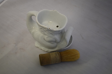
Household, Shaving mug & brush, Early 20th century
... This shaving set has no known local provenance and is kept for display purposes. bathroom accessories history of warrnambool This is a shaving set with a white china mug in the shape of a fish with a mouth where the excess water and lather are ejected and it has a handle in the shape of a fish’s tail. ...This shaving set was used, mostly by men, to lather the face prior to shaving. Ornamental mugs such as this one were often given as presents. Today most men use electric shavers. This shaving set has no known local provenance and is kept for display purposes.This is a shaving set with a white china mug in the shape of a fish with a mouth where the excess water and lather are ejected and it has a handle in the shape of a fish’s tail. The top open section that contains room for the lather and water has white ornamentation around the outer section and has three holes inside for drainage. There is evidence of some gilt decoration around the mouth and eye of the fish and the open top section but this is now mostly rubbed away. The brush has a wooden handle with cotton braiding and hair (probably horsehair). The brush is a little worn. bathroom accessories, history of warrnambool -
 Warrnambool and District Historical Society Inc.
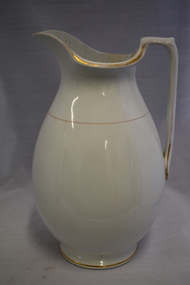
Household, Jug, Early 20th century
... In the days before there were sinks with hot and cold running water in bathrooms, a jug such as this was an essential item and would have been in common use up to the first three decades of the 20th century. Today this item is more likely to be used as a vase This jug has no known local provenance and is kept as a memento of a household item in use 100 years ago. ...This is a bathroom jug and could have been part of a set for bathroom use. It would have held mainly water, hot or cold. In the days before there were sinks with hot and cold running water in bathrooms, a jug such as this was an essential item and would have been in common use up to the first three decades of the 20th century. Today this item is more likely to be used as a vaseThis jug has no known local provenance and is kept as a memento of a household item in use 100 years ago. This is a large white china jug. The body of the jug is spherical or bulbous shaped, tapering to a smaller neck and a large lip. There is gold trim around the handle, the rim of the top opening, around the base and around the top part of the jug. The handle has a straight edge. The jug is stained inside and there is a small piece of china missing on the base. bathroom accessories, history of warrnambool -
 Warrnambool and District Historical Society Inc.
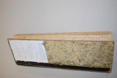
Administrative record - Warrnambool Water Trust Notebook, late 19th century (1892-1900)
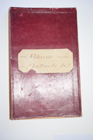
... This notebook is of some interest as it supplies details of a late 19th century Warrnambool water supply scheme and so should be of value to local history researchers Warrnambool Water Supply warrnambool water board 19th century water in warrnambool Returns Contracts 1 & 2 This is a notebook with a red leather cover and pages with printed headings and ruled red lines. ...This notebook appears to be the Warrnambool Water Trust Records of two contracts in 1892 . (The reference is written as 'W.W.Trust'.) The first contract, with the contractors, Coates and Reed, is for the excavation for settling tanks and clear water basin and a reservoir in Liebig Street and there are 60 pages giving details of these works - labour, masonry, concreting, fencing etc. The second contract with the contractor, William Kellas, is for the erection of a cottage and an engine shed and boiler room (7 pages). The Warrnambool Water Trust was set up in 1891 and the first project was the supply of water from the Merri River near Wollaston to a reservoir and tower in Liebig Street and this notebook concerns some details of this early water supply scheme. This notebook is of some interest as it supplies details of a late 19th century Warrnambool water supply scheme and so should be of value to local history researchers This is a notebook with a red leather cover and pages with printed headings and ruled red lines. The pages contain handwriting in black ink. The cover has a label (partly torn) with handwriting.Returns Contracts 1 & 2warrnambool water supply, warrnambool water board, 19th century water in warrnambool -
 Warrnambool and District Historical Society Inc.
Administrative record (collection) - Warrnambool Town/ City Council Newspaper Reports, 1897 - 1925
... local Warrnambool Standard supplied detailed reports of these meetings. Warrnambool became a city in 1918. The Warrnambool Standard newspaper commenced in 1872 and continues today. These ledgers are a very useful tool for researchers, especially in regard to the Warrnambool Botanic Gardens, the Gas Works, the Sea Water Baths , Engineering Projects, Electricity Supply and the Local Museum Warrnambool Town/ City Council meetings. ...Warrnambool City Council CollectionHistorical RecordInformation contained in three ledgersNewspaper cuttings from The Warrnambool Standard concerning the Warrnambool Town/ City Councilwarrnambool town/ city council meetings.warrnambool town/ city council meetings. -
 Warrnambool and District Historical Society Inc.
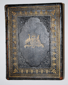
Book, David Blair, The History of Australasia, 1878
... local provenance. Australasian History Alice gamble A history of Australasia 1870 Warrnambool alice hilder A history of Australasia written in late 1800's Alice Eva Gamble From her affectionate husband William Graham Gamble 20th October 1879 The book has black leather covers which are heavily embossed with an Australian Coat of Arms and featuring gold printing, scroll work and patterns. The title of the book is on the spine which also has gold patterns. The cover is torn at the top left hand corner. The inside cover is water ...A history of Australasia written in late 1800'sThe book has black leather covers which are heavily embossed with an Australian Coat of Arms and featuring gold printing, scroll work and patterns. The title of the book is on the spine which also has gold patterns. The cover is torn at the top left hand corner. The inside cover is water damaged. The gilt edged pages contain printed text, black and white and tinted illustrations and coloured maps. There is a narrow ribbon book mark , a pressed leaf and a cut out card flower inserted in the pages.non-fictionA history of Australasia written in late 1800'saustralasian history, alice gamble, a history of australasia 1870, warrnambool, alice hilder -
 Warrnambool and District Historical Society Inc.
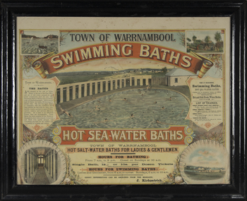
Photograph - Framed photograph of Warrnambool Salt Water Baths, c. 1920
... A building nearby housed marble cubicles with hot spa baths with the water heated on the site and a caretaker's cottage completed the complex. Men's nude bathing was a feature of the early 20th century. Originally built by a local...A building nearby housed marble cubicles with hot spa baths with the water heated on the site and a caretaker's cottage completed the complex. Men's nude bathing was a feature of the early 20th century. Originally built by a local ...This is a framed photograph of the men's pool at the Warrnambool Salt Water Baths. These Baths were originally built at the end of Gilles Street on the line of the present railway line in 1876 but were rebuilt in 1889 further north in Gilles Street when the railway line was opened. The water was pumped from the sea, initially by a windmill and later by a gas pump. The men's pool was 100 feet by 50 feet and the women's pool was 60 feet by 30 feet with bathing strictly segregated in the 19th century. A building nearby housed marble cubicles with hot spa baths with the water heated on the site and a caretaker's cottage completed the complex. Men's nude bathing was a feature of the early 20th century. Originally built by a local public company the Baths were taken over by the Warrnambool Council. These baths were superseded by the opening in 1961 of an Olympic Pool In Warrnambool. The site and the remaining buildings of the old sea water baths are now heritage-listed and today form part of the headquarters of the Warrnambool and District Historical Society.This photograph is of historical significance as a depiction of the Warrnambool Salt water Baths in the early 20th century. These Baths were the basis for promoting Warrnambool as a health and spa resort town in the late 19th and early 20th centuries.This is a framed black and white photograph of the men's pool at the Warrnambool Salt Water Baths. It depicts men and boys swimming in the circular pool and one male on the diving board. All these men are naked. There are other clothed males and clothed attendants wearing hats and waistcoats. The change rooms are on the right side of the photograph and there is a fence with trees behind. The photograph is mounted on cardboard with a gilt edge and is held in a wooden ridged frame behind glass. warrnambool sea water baths, sea baths, warrnambool pool, gilles street