Showing 6416 items matching "location"
-
 Moorabbin Air Museum
Booklet - ANSETT AIR FREIGHT NATIONAL LOCATION GUIDE TO 12,294 DESTINATIONS IN AUSTRALIA, ANSETT AIR FREIGHT NATIONAL LOCATION GUIDE TO 12,294 DESTINATIONS IN AUSTRALIA, NO DATE
... ANSETT AIR FREIGHT NATIONAL LOCATION GUIDE TO 12,294 DESTINATIONS IN AUSTRALIA...ANSETT AIR FREIGHT NATIONAL LOCATION GUIDE TO 12,294 DESTINATIONS IN AUSTRALIA...Moorabbin Air Museum Moorabbin Airport 12 First Street Moorabbin melbourne ANSETT AIR FREIGHT NATIONAL LOCATION GUIDE TO 12,294 DESTINATIONS IN AUSTRALIA Booklet ANSETT AIR FREIGHT NATIONAL LOCATION GUIDE TO 12,294 DESTINATIONS IN AUSTRALIA ANSETT AIR FREIGHT NATIONAL LOCATION GUIDE TO 12,294 DESTINATIONS IN AUSTRALIA ... -
 Bendigo Military Museum
Photograph - 4th Field Survey Squadron Adventurous Training, Unknown Location, SA, 1994
... 4th Field Survey Squadron Adventurous Training, Unknown Location, SA...This is a set of 28 photographs of 4th Field Survey Squadron undergoing adventurous training held at unknown locations in South Australia, in 1994. It is also possible the training was in the Grampians region of Victoria. ...This is a set of 28 photographs of 4th Field Survey Squadron personnel undergoing adventurous training held at unknown locations in South Australia in 1994. The colour photographs are on 35mm negative film and are part of the Army Survey Regiment’s Collection. ......Unknown location, South Australia...L to R: SPR Fran Calvert, unidentified, SPR Gordon Santo, SPR Matt Arnold, SGT Dave Cook. 4th Field Survey Squadron Adventurous Training, Unknown Location, SA Photograph 4th Field Survey Squadron Adventurous Training, Unknown Location, SA Army Survey Regiment ...This is a set of 28 photographs of 4th Field Survey Squadron undergoing adventurous training held at unknown locations in South Australia, in 1994. It is also possible the training was in the Grampians region of Victoria. Off-road driver training and abseiling were key activities of this adventurous training as well as teamwork, leadership, and field craft. Elements from units of the Army Reserve may have participated in the training. See items 6561.31P, 6562.33P and 6563.33P for more photos taken during this training activity.This is a set of 28 photographs of 4th Field Survey Squadron personnel undergoing adventurous training held at unknown locations in South Australia in 1994. The colour photographs are on 35mm negative film and are part of the Army Survey Regiment’s Collection. The photographs were scanned at 96 dpi. .1) - Photo, colour, 1994. Abseiling. Unidentified personnel. .2) - Photo, colour, 1994. Abseiling. L to R: Unidentified (x2), WO2 Ken Talbot-Smith, unidentified, SGT Mark Donnelly, unidentified. .3) to .10) - Photo, colour, 1994. Training area terrain. .11) to .12) - Photo, colour, 1994. Abseiling. Unidentified personnel. .13) to .14) - Photo, colour, 1994. Training area terrain. .15) - Photo, colour, 1994. Training area terrain. L to R: SSGT Brian ‘BC’ Collings, unidentified (x6). .16) - Photo, colour, 1994. Training area terrain. .17) - Photo, colour, 1994. Training area terrain. Unidentified personnel. .18) - Photo, colour, 1994. Training area terrain. L to R: SSGT Brian ‘BC’ Collings, SGT Steve McGuiness. .19) - Photo, colour, 1994. Training area terrain. .20) to .27) - Photo, colour, 1994. Abseiling. Unidentified soldiers. .28) - Photo, colour, 1994. Returning to 4 Fd Svy Sqn. L to R: SPR Fran Calvert, unidentified, SPR Gordon Santo, SPR Matt Arnold, SGT Dave Cook..1P to .28P – There are no personnel identified. ‘1994 ADV TRAINING’ annotated on negatives sleeve.royal australian survey corps, rasvy, 4 fd svy sqn -
 Bendigo Military Museum
Photograph - 4th Field Survey Squadron Adventurous Training, Unknown Location, SA, 1994
... 4th Field Survey Squadron Adventurous Training, Unknown Location, SA...This is a set of 33 photographs of 4th Field Survey Squadron undergoing adventurous training held at unknown locations in South Australia, in 1994. It is also possible the training was in the Grampians region of Victoria. ...This is a set of 33 photographs of 4th Field Survey Squadron personnel undergoing adventurous training held at unknown locations in South Australia in 1994. The colour photographs are on 35mm negative film and are part of the Army Survey Regiment’s Collection. ......Unknown location, South Australia...Unidentified soldier. 4th Field Survey Squadron Adventurous Training, Unknown Location, SA Photograph 4th Field Survey Squadron Adventurous Training, Unknown Location, SA Army Survey Regiment ...This is a set of 33 photographs of 4th Field Survey Squadron undergoing adventurous training held at unknown locations in South Australia, in 1994. It is also possible the training was in the Grampians region of Victoria. Off-road driver training and abseiling were key activities of this adventurous training as well as teamwork, leadership, and field craft. Elements from units of the Army Reserve may have participated in the training. See items 6561.31P, 6562.33P and 6564.28P for more photos taken during this training activity.This is a set of 33 photographs of 4th Field Survey Squadron personnel undergoing adventurous training held at unknown locations in South Australia in 1994. The colour photographs are on 35mm negative film and are part of the Army Survey Regiment’s Collection. The photographs were scanned at 96 dpi. .1) - Photo, colour, 1994. Preparation. LCPL Mitch Oake. .2) - Photo, colour, 1994. Preparation. SPR Chris Pearse. .3) & .4) - Photo, colour, 1994. Preparation. Unidentified soldier. .5) - Photo, colour, 1994. Preparation. SSGT Pat ‘Fuji’ Drover. .6) - Photo, colour, 1994. Preparation. L to R: SGT Steve McGuiness, CPL Steve Wegener, CPL Dick Crawford, CPL Peter Ball, SPR Greg Richards. .7) - Photo, colour, 1994. Preparation. L to R: CPL Peter Ball, SPR Greg Richards. .8) to .10) - Photo, colour, 1994. Preparation. SSGT Lynn Johnson. .11) - Photo, colour, 1994. Social activities. L to R: Unidentified (x8), SPR Chris Pearse, SSGT Lynn Johnson. .12) - Photo, colour, 1994. Social activities. SGT Dave Longbottom. .13) to .15) - Photo, colour, 1994. Social activities. Unidentified personnel. .16) - Photo, colour, 1994. Social activities. L to R: SGT Dave Cook, WO2 Simon ‘Andy’ Capp, CAPT Rob Gray, SPR Chris Pearse, SPR Mark McInerney. .17) to .19) - Photo, colour, 1994. Training area terrain. .20) to .23) - Photo, colour, 1994. Driver training. .24) - Photo, colour, 1994. Training area terrain. .25) - Photo, colour, 1994. Abseiling. SSGT Pat ‘Fuji’ Drover. .26) - Photo, colour, 1994. Abseiling. SGT Mark Donnelly. .27) to .33)- Photo, colour, 1994. Abseiling. Unidentified soldier. .1P to .33P – There are no personnel identified. ‘1994 ADV TRAINING’ annotated on negatives sleeve.royal australian survey corps, rasvy, 4 fd svy sqn -
 Bendigo Military Museum
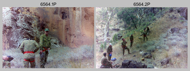
Photograph - 4th Field Survey Squadron Adventurous Training, Unknown Location, SA, 1994
... 4th Field Survey Squadron Adventurous Training, Unknown Location, SA...This is a set of 33 photographs of 4th Field Survey Squadron undergoing adventurous training held at unknown locations in South Australia, in 1994. It is also possible the training was in the Grampians region of Victoria. ...This is a set of 33 photographs of 4th Field Survey Squadron personnel undergoing adventurous training held at unknown locations in South Australia in 1994. The colour photographs are on 35mm negative film and are part of the Army Survey Regiment’s Collection. ......Unknown location, South Australia...Unidentified soldier. 4th Field Survey Squadron Adventurous Training, Unknown Location, SA Photograph 4th Field Survey Squadron Adventurous Training, Unknown Location, SA Army Survey Regiment ...This is a set of 33 photographs of 4th Field Survey Squadron undergoing adventurous training held at unknown locations in South Australia, in 1994. It is also possible the training was in the Grampians region of Victoria. Off-road driver training and abseiling were key activities of this adventurous training as well as teamwork, leadership, and field craft. Elements from units of the Army Reserve may have participated in the training. See items 6561.31P, 6563.33P and 6564.28P for more photos taken during this training activity.This is a set of 33 photographs of 4th Field Survey Squadron personnel undergoing adventurous training held at unknown locations in South Australia in 1994. The colour photographs are on 35mm negative film and are part of the Army Survey Regiment’s Collection. The photographs were scanned at 96 dpi. .1) - Photo, colour, 1994. Abseiling. L to R: SGT Steve McGuiness, SPR Chris Pearse, SPR Mark McInerney. .2) - Photo, colour, 1994. Abseiling. L to R: CAPT Rob Gray, SSGT Lynn Johnson, CPL Stuart Adrain, unidentified. .3) - Photo, colour, 1994. Abseiling. Top of cliff. .4) - Photo, colour, 1994. Abseiling. L to R: Mark Linwood, unidentified. .5) - Photo, colour, 1994. Abseiling. Unidentified soldier. .6) - Photo, colour, 1994. Abseiling. Unidentified, WO2 Simon ‘Andy’ Capp. .7) & .8) - Photo, colour, 1994. Abseiling. CPL Steve Wegener. .9) & .10) - Photo, colour, 1994. Abseiling. L to R: SPR Greg Richards, unidentified. .11) - Photo, colour, 1994. Abseiling. SPR Chris Pearse, unidentified (x2). .12) & .13) - Photo, colour, 1994. Abseiling. SPR Mark McInerney. .14) - Photo, colour, 1994. Abseiling. Unidentified personnel. .15) - Photo, colour, 1994. Abseiling. SPR Marc Zehntner. .16) - Photo, colour, 1994. Abseiling. SPR Mark McInerney, unidentified. .17) & .18) - Photo, colour, 1994. Abseiling. CAPT Rob Gray. .19) - Photo, colour, 1994. Abseiling. SGT Steve McGuiness. .20) - Photo, colour, 1994. Abseiling. CPL Steve Wegener. .21) - Photo, colour, 1994. Abseiling. L to R: SPR Greg Richards, unidentified. .22) - Photo, colour, 1994. Abseiling. SPR Greg Richards. .23) to .25) - Photo, colour, 1994. Abseiling. SPR Mark Linwood. .26) - Photo, colour, 1994. Abseiling. L to R: CPL Steve Wegener, CAPT Rob Gray, unidentified. .27) & .28) - Photo, colour, 1994. Abseiling. SSGT Lynn Johnson. .29) - Photo, colour, 1994. Abseiling. SGT Steve McGuiness. .30) - Photo, colour, 1994. Abseiling. Unidentified soldier. .31) - Photo, colour, 1994. Abseiling. SPR Mark McInerney. .32) - Photo, colour, 1994. Abseiling. CAPT Rob Gray. .33) - Photo, colour, 1994. Abseiling. Unidentified soldier..1P to .33P – There are no personnel identified. ‘1994 ADV TRAINING’ annotated on negatives sleeve.royal australian survey corps, rasvy, 4 fd svy sqn -
 Bendigo Military Museum
Photograph - 4th Field Survey Squadron Adventurous Training, Unknown Location, SA, 1994
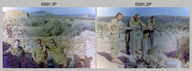
... 4th Field Survey Squadron Adventurous Training, Unknown Location, SA...This is a set of 31 photographs of 4th Field Survey Squadron undergoing adventurous training held at unknown locations in South Australia, in 1994. It is also possible the training was in the Grampians region of Victoria. ...This is a set of 31 photographs of 4th Field Survey Squadron personnel undergoing adventurous training held at unknown locations in South Australia in 1994. The colour photographs are on 35mm negative film and are part of the Army Survey Regiment’s Collection. ......Unknown location, South Australia...Unidentified personnel. 4th Field Survey Squadron Adventurous Training, Unknown Location, SA Photograph 4th Field Survey Squadron Adventurous Training, Unknown Location, SA Army Survey Regiment ...This is a set of 31 photographs of 4th Field Survey Squadron undergoing adventurous training held at unknown locations in South Australia, in 1994. It is also possible the training was in the Grampians region of Victoria. Off-road driver training and abseiling were key activities of this adventurous training as well as teamwork, leadership, and field craft. Elements from units of the Army Reserve may have participated in the training. See items 6562.33P, 6563.33P and 6564.28P for more photos taken during this training activity.This is a set of 31 photographs of 4th Field Survey Squadron personnel undergoing adventurous training held at unknown locations in South Australia in 1994. The colour photographs are on 35mm negative film and are part of the Army Survey Regiment’s Collection. The photographs were scanned at 96 dpi. .1) - Photo, colour, 1994. Old ruins. L to R: SGT Steve McGuiness, SPR Chris Pearse, SPR Mark Linwood. .2) - Photo, colour, 1994. Old ruins. L to R: CPL Steve Wegener, SPR Mark Linwood. SGT Steve McGuiness. .3) - Photo, colour, 1994. Old grave. SPR Mark Linwood. .4) to .7) - Photo, colour, 1994. Driver training. Unidentified personnel. .8) - Photo, colour, 1994. Driver training. CPL Steve Wegener. .9) to .12) - Photo, colour, 1994. Driver training. Unidentified personnel. .13) - Photo, colour, 1994. Driver training and hiking. L to R: SPR Greg Richards, SPR Mark McInerney. .14) - Photo, colour, 1994. Driver training and hiking. L to R: SPR Chris Pearse, WO2 Simon ‘Andy’ Capp. .15) - Photo, colour, 1994. Driver training and hiking. Unidentified personnel. .16) - Photo, colour, 1994. Driver training and hiking. L to R: CPL Steve Wegener, CAPT Rob Gray, unidentified (x2), SPR Chris Pearse, WO2 Simon ‘Andy’ Capp. .17) to .18) - Photo, colour, 1994. Driver training. Unidentified personnel. .19) - Photo, colour, 1994. Driver training and hiking. L to R: WO2 Simon ‘Andy’ Capp, SPR Chris Pearse, CPL Stuart Adrain, SPR Mark McInerney. .20) - Photo, colour, 1994. Driver training and hiking. L to R: CPL Stuart Adrain, unidentified, CAPT Rob Gray, WO2 Simon ‘Andy’ Capp, SPR Chris Pearse, SPR Mark McInerney. .21) - Photo, colour, 1994. Driver training and hiking. Unidentified personnel. .22) - Photo, colour, 1994. Driver training and hiking. L to R: unidentified, CPL Stuart Adrain, SPR Mark McInerney, CAPT Rob Gray, remainder unidentified. .23) - Photo, colour, 1994. Abseiling. L to R: SGT Steve McGuiness, unidentified, CPL Steve Wegener, CPL Stuart Adrain. .24) & .25) - Photo, colour, 1994. Abseiling. WO2 Simon ‘Andy’ Capp. .26) - Photo, colour, 1994. Abseiling. CAPT Rob Gray. .27.) to .31) - Photo, colour, 1994. Abseiling. Unidentified personnel..1P to .31P – There are no personnel identified. ‘1994 ADV TRAINING’ annotated on negatives sleeve.royal australian survey corps, rasvy, 4 fd svy sqn -
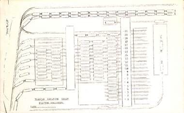
 Melbourne Tram Museum
Drawing, Melbourne & Metropolitan Tramways Board (MMTB), "Route Map showing location of special work and pole numbers" "substations", late 1942
... "Route Map showing location of special work and pole numbers" "substations"...Shows underground cables, tram and bus depot, workshop locations, and substation locations and their priority....Drawing - dyeline cloth backed print - titled - "Route Map showing location of special work and pole numbers" and subtitled - "Substations". ...Shows underground cables, tram and bus depot, workshop locations, and substation locations and their priority. ...Map of the system shown at two inches = 1 mile. Drawing No. P5799. Shows crossovers, track layouts at junctions, signal cabins roads, railways, and stations. Originally signed by Perway Engineer - 20/12/1940, though originally drawn in 1922. The plan shows the lines to Maribyrnong Munitions works along Cordite Ave and Wests Road and the track from Moonee Ponds to Union Road, opened in July 1941, and the extension to Essendon Airport built in 1942, but not the Queen St North Essendon substation. Shows underground cables, tram and bus depot, workshop locations, and substation locations and their priority.Yields information about the MMTB substation locations in 1942.Drawing - dyeline cloth backed print - titled - "Route Map showing location of special work and pole numbers" and subtitled - "Substations". trams, tramways, mmtb, trackwork, tramways, junction, map, world war 2, substation -
 Federation University Historical Collection
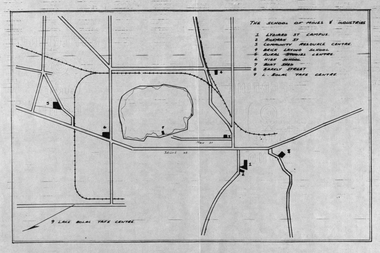
Plan, School of Mines and Industries: Location of buildings, Ballarat
... School of Mines and Industries: Location of buildings, Ballarat...Printed map showing Ballarat School of Mines locations....Barker Library (top floor) Mount Helen goldfields Ballarat School of Mines plan ballarat lake wendouree Printed map showing Ballarat School of Mines locations. School of Mines and Industries: Location of buildings, Ballarat Plan Plan ...Printed map showing Ballarat School of Mines locations.ballarat school of mines, plan, ballarat, lake wendouree -
 Queenscliffe Maritime Museum
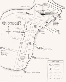
Drawing - Drawing showing the Queenscliffe Maritime Centre's [QMC} location in 1987, Map showing QMC location in 1987, 1987
... Map showing QMC location in 1987....Drawing showing the Queenscliffe Maritime Centre's [QMC} location in 1987....Map showing QMC location in 1987. Drawing Drawing showing the Queenscliffe Maritime Centre's [QMC} location in 1987. ...Queenscliffe Maritime Centre historyLocation map of the original Queenscliffe Drawing showing the Queenscliffe Maritime Centre's [QMC} location in 1987.Reverse " NIL " -
 Federation University Historical Collection
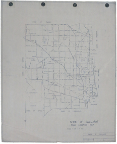
Map, Shire of Ballarat Road Location Map, 1968, 05/06/2014
... Shire of Ballarat Road Location Map, 1968...White paper road location map. Scale 1 mile to 1 inch...Barker Library (top floor) Mount Helen goldfields ballarat shire of ballarat roads dowling forest lake burumbeet lake learmonth ascot windermere tourello White paper road location map. Scale 1 mile to 1 inch Shire of Ballarat Road Location Map, 1968 Map Map ...White paper road location map. Scale 1 mile to 1 inchballarat, shire of ballarat, roads, dowling forest, lake burumbeet, lake learmonth, ascot, windermere, tourello -
 Lakes Entrance Historical Society
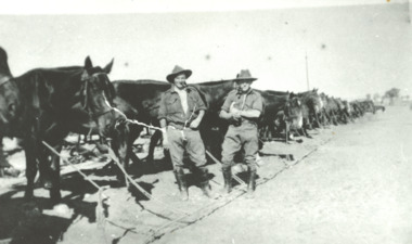
Photograph, Horses and two attendants in a desert location WW1 Egypt, 1916 c
... Horses and two attendants in a desert location WW1 Egypt...Black and white photograph of line of unsaddled horses and two attendants in a desert location WW1 Egypt...Lakes Entrance Historical Society 4 Marine Parade Lakes Entrance gippsland World War 1914-1918 Animals soldiers Black and white photograph of line of unsaddled horses and two attendants in a desert location WW1 Egypt Horses and two attendants in a desert location WW1 Egypt Photograph ...Black and white photograph of line of unsaddled horses and two attendants in a desert location WW1 Egyptworld war 1914-1918, animals, soldiers -
 Melbourne Tram Museum
Document - Report, Melbourne & Metropolitan Tramways Board (MMTB), "Tramcar location sheet - Preston Workshops"
... "Tramcar location sheet - Preston Workshops"...Foolscap duplicated sheet providing a blank form for "Tramcar location sheet - Preston Workshops" - form R438...Yields information about the form that would have provided daily information to workshop staff regarding tramcar locations and progress of work. tramcars tramways MMTB Preston Workshops planning Foolscap duplicated sheet providing a blank form for "Tramcar location sheet - Preston Workshops" - form R438 "Tramcar location sheet - Preston Workshops" Document Report Melbourne & Metropolitan Tramways Board (MMTB) ...Enabled a report or diagram showing where each tramcar was located at the date within Preston Workshops. This would have enabled workshop planning and tramcar movements. Yields information about the form that would have provided daily information to workshop staff regarding tramcar locations and progress of work.Foolscap duplicated sheet providing a blank form for "Tramcar location sheet - Preston Workshops" - form R438tramcars, tramways, mmtb, preston workshops, planning -
Friends of Ballarat Botanical Gardens History Group
Work on paper - Ballarat Botanical Gardens - Plaques, Location, Name and Item, c 2005
... Location, Name and Item ......Location...Location, Name and Item Work on paper Ballarat Botanical Gardens - Plaques ...Each plaque is listed whether it is naming a sculpture, statue, lawn, tree, seat, garden, or pond. The plaques are important not only to those who are directly associated with the Ballarat Botanical Gardens but as important information available to the general public.Three pages, 21/2 of print in three columns.Noneballarat botanical gardens, plaques, location, name, item, john garner collection, garner, dr, gardens, ballarat -
 Bendigo Military Museum
Photograph - 4th Field Survey Squadron Adventurous Training, Unknown Location, SA, 1990
... 4th Field Survey Squadron Adventurous Training, Unknown Location, SA. ...This is a set of seven photographs of 4th Field Survey Squadron undergoing adventurous training held at an unknown location in South Australia, in 1990. It is probable the training focussed on teamwork, leadership, field craft and living off the land survival skills. ...This is a set of seven photographs of 4th Field Survey Squadron personnel undergoing adventurous training held at an unknown location in South Australia in 1990. The colour photographs are on 35mm negative film and are part of the Army Survey Regiment’s Collection. ...L to R: unidentified (x2), SPR Pat Austine, SGT John Zuringer, unidentified (x2). 4th Field Survey Squadron Adventurous Training, Unknown Location, SA. Photograph 4th Field Survey Squadron Adventurous Training, Unknown Location, SA. ...This is a set of seven photographs of 4th Field Survey Squadron undergoing adventurous training held at an unknown location in South Australia, in 1990. It is probable the training focussed on teamwork, leadership, field craft and living off the land survival skills. Elements from units of the Army Reserve may have participated in the training. This is a set of seven photographs of 4th Field Survey Squadron personnel undergoing adventurous training held at an unknown location in South Australia in 1990. The colour photographs are on 35mm negative film and are part of the Army Survey Regiment’s Collection. The photographs were scanned at 96 dpi. .1) - Photo, colour, 1990. Unidentified personnel. .2) & .3) - Photo, colour, 1990. L to R: unidentified, SGT John Zuringer, unidentified. .4) - Photo, colour, 1990. L to R: SPR Pat Austine, unidentified. .5) - Photo, colour, 1990. SPR Doug Willis. .6) - Photo, colour, 1990. L to R: SPR Pat Austine, SPR Doug Willis. .7) - Photo, colour, 1990. L to R: unidentified (x2), SPR Pat Austine, SGT John Zuringer, unidentified (x2)..1P to .7P – There are no personnel identified. ‘1990 ADV TRAINING’ annotated on negatives sleeve.royal australian survey corps, rasvy, 4 fd svy sqn -
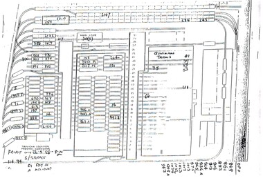 Melbourne Tram Museum
Administrative record - Depot List, Melbourne & Metropolitan Tramways Board (MMTB), "Tramcar location Preston Workshops", May. 1998
... "Tramcar location Preston Workshops"...A4 photocopied sheet providing the location of tramcars at Preston Workshops, dated 22-5-1998. ...Melbourne Tram Museum 8 Wallen Road Hawthorn melbourne Trams tramways Preston Workshops Lists A4 photocopied sheet providing the location of tramcars at Preston Workshops, dated 22-5-1998. ...A4 photocopied sheet providing the location of tramcars at Preston Workshops, dated 22-5-1998. Has notes whether in for "day in" or "accident repairs".trams, tramways, preston workshops, lists -
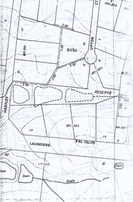 Wonga Park Community Cottage History Group
Plan - Location Plans, of the dams on the Arthur John Upton Reserve in Wonga Park, of the location of the Reserve and a street plan of the area
... of the dams on the Arthur John Upton Reserve in Wonga Park, of the location of the Reserve and a street plan of the area...Plans of the location of the dams on the Arthur John Upton Reserve in Wonga Park. ...Of the location of the Reserve and a street plan of the area of the dams on the Arthur John Upton Reserve in Wonga Park, of the location of the Reserve and a street plan of the area Plan Location Plans ...Plans of the location of the dams on the Arthur John Upton Reserve in Wonga Park. Of the location of the Reserve and a street plan of the area -
Stawell Historical Society Inc
Map, Western Mining Corporation Limited, Shaft Location Plan April 1981, 1981
... Western Mining Corporation Limited, Shaft Location Plan April 1981...Western Mining Corporation Ltd Shaft Location Plan 1981 Very Large Plot Showing Contours and Streets Without names. ...Sheet 1 0f 2 Western Mining Corporation Limited, Shaft Location Plan April 1981 Map ...Western Mining Corporation Ltd Shaft Location Plan 1981 Very Large Plot Showing Contours and Streets Without names. Sheet 1 0f 2 stawell, mining -
Stawell Historical Society Inc
Map, Western Mining Corporation Ltd Shaft Location Plan 1981, 1981
... Western Mining Corporation Ltd Shaft Location Plan 1981 ... Western Mining Corporation Ltd Shaft Location Plan 1981 Very Large Plot Showing Contours and Streets Without names. ...Sheet 2 0f 2 Western Mining Corporation Ltd Shaft Location Plan 1981 Map ...Western Mining Corporation Ltd Shaft Location Plan 1981 Very Large Plot Showing Contours and Streets Without names. Sheet 2 0f 2 stawell, mining -
 Melbourne Tram Museum
Drawing, Melbourne & Metropolitan Tramways Board (MMTB), "Route Map showing location of special work and pole numbers" "All night tram routes in colours", late 1941
... "Route Map showing location of special work and pole numbers" "All night tram routes in colours"...Drawings - dyeline cloth-backed print - titled - "Route Map showing the location of special work and pole numbers" and subtitled - "All night tram routes in colours". ..."Route Map showing location of special work and pole numbers" "All night tram routes in colours" Drawing Melbourne & Metropolitan Tramways Board (MMTB) ...Map of the system shown at two inches = 1 mile. Drawing No. P5799. Shows crossovers, track layouts at junctions, signal cabins roads, railways, and stations. Originally signed by Perway Engineer - 20/12/1940, though originally drawn in 1922. Has been marked up in colour pencil to show the all-night routes and the individual services. The plan shows the lines to Maribyrnong Munitions works along Cordite Ave and Wests Road and the track from Moonee Ponds to Union Road, opened in July 1941, but not the extension to Essendon Airport built in 1942.Demonstrates a detail drawing of Melbourne tramways, junctions and pole numbers.Drawings - dyeline cloth-backed print - titled - "Route Map showing the location of special work and pole numbers" and subtitled - "All night tram routes in colours". trams, tramways, mmtb, trackwork, tramways, junction, map, world war 2, night trams -
 Bendigo Military Museum
Photograph - Army Survey Regiment Regimental Training Reconnaissance, unknown location, Victoria, 1990
... Army Survey Regiment Regimental Training Reconnaissance, unknown location, Victoria...This is a set of six photographs of Army Survey Regiment officers in 1990 assessing the potential of an unknown Victorian location for a future regimental training exercise or adventurous training. ...This is a set of six photographs of Army Survey Regiment officers in 1990 assessing the potential of an unknown Victorian location for a future regimental training exercise. ...Army Survey Regiment Regimental Training Reconnaissance, unknown location, Victoria Photograph Army Survey Regiment Regimental Training Reconnaissance, unknown location, Victoria Army Survey Regiment ...This is a set of six photographs of Army Survey Regiment officers in 1990 assessing the potential of an unknown Victorian location for a future regimental training exercise or adventurous training. The aim of regimental training was typically to provide personnel a practical knowledge of infantry and minor tactics (IMT) at the section level, navigation and map reading, RATEL and survival in the Field. The unidentified terrain may have been in the Grampians or the sub-alpine high country in north-eastern Victoria.This is a set of six photographs of Army Survey Regiment officers in 1990 assessing the potential of an unknown Victorian location for a future regimental training exercise. Black and white photographs are on 35mm negative film and scanned at 2400 dpi. They are part of the Army Survey Regiment’s Collection. .1) - Photo, black and white, 1990. LT Marty Lyons in unknown Victorian terrain. .2) - Photo, black and white, 1990. Unknown Victorian terrain. .3) - Photo, black and white, 1990. LT Craig Hersant in unknown Victorian terrain. .4) - Photo, black and white, 1990. Unknown Victorian terrain. .5) - Photo, black and white, 1990. LT Craig Hersant in unknown Victorian terrain. .6) - Photo, black and white, 1990. LT Marty Lyons in unknown Victorian terrain.There are no personnel identified.royal australian survey corps, rasvy, army survey regiment, army svy regt, fortuna -
 Ballarat Tramway Museum
Drawing - W-598, State Electricity Commission of Victoria (SECV), Location of Hardness Tests on Tramway. Brakes Shoes & Tyres, 23/05/1956
... Location of Hardness Tests on Tramway. Brakes Shoes & Tyres....SEC drawing number W-598, "Location of Hardness Tests on Tramway. Brake Shoes & Tyres". ...Beige paper copy of original dyeline print. Location of Hardness Tests on Tramway. Brakes Shoes & Tyres. ...Yields information regarding hardness tests carried out on tramway tyres and brake shoes.SEC drawing number W-598, "Location of Hardness Tests on Tramway. Brake Shoes & Tyres". Drawn 23/05/1956. Beige paper copy of original dyeline print.Copy of originalsecv, state electricity commission of victoria, ballarat tramway, ballarat tramway museum, ballarat, electricity supply department, works division -
 Melbourne Tram Museum
Drawing, Melbourne & Metropolitan Tramways Board (MMTB), "Route Map showing location of special work and pole numbers" "Electric Tramway Routes - showing routes in colours and numbers", late 1941
... "Route Map showing location of special work and pole numbers" "Electric Tramway Routes - showing routes in colours and numbers"...Drawings - dyeline cloth backed print - titled - "Route Map showing location of special work and pole numbers" and subtitled - "Electric Tramway Routes - showing routes in colours and numbers". ..."Route Map showing location of special work and pole numbers" "Electric Tramway Routes - showing routes in colours and numbers" Drawing Melbourne & Metropolitan Tramways Board (MMTB) ...Map of the system shown at two inches = 1 mile. Drawing No. P5799. Shows crossovers, track layouts at junctions, signal cabins roads, railways and stations. Originally signed by Perway Engineer - 20/12/1940, though originally drawn in 1922. Has been marked up in coloured pencil to show the routes and route numbers. The plan shows the lines to Maribyrnong Munitions works along Cordite Ave and Wests Road and the track from Moonee Ponds to Union Road, which opened in July 1941, but not the extension to Essendon Airport built-in 1942. See Reg Item 1561 for a 1963 version and 1683 for a 1987 versionDemonstrates the use of a MMTB drawing to show tram routes and their route numbers at the time.Drawings - dyeline cloth backed print - titled - "Route Map showing location of special work and pole numbers" and subtitled - "Electric Tramway Routes - showing routes in colours and numbers". trams, tramways, mmtb, trackwork, tramways, junction, map, world war 2 -
 Ballarat Tramway Museum
Drawing - GE-T1-6228, State Electricity Commission of Victoria (SECV), Location of Proposed Loop in Corio Terrace for Shunting Cars, 27/10/1959
... Location of Proposed Loop in Corio Terrace for Shunting Cars...MESCO drawing number GE-T1-6228, "Location of Proposed Loop in Corio Terrace for Shunting Cars". ...MESCO drawing number GE-T1-6228, "Location of Proposed Loop in Corio Terrace for Shunting Cars". ...Yields information regarding the mounting of advertising signs to tram bodies, both single truck and double bogie cars.MESCO drawing number GE-T1-6228, "Location of Proposed Loop in Corio Terrace for Shunting Cars". Drawn 10/1/1929. Beige paper copy of original dyeline print. Copy of original.electricity supply department, works division, geelong, geelong tramways, melbourne electric supply co. ltd., mesco -
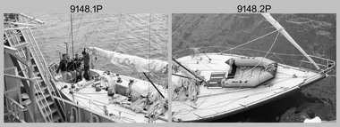
 Bendigo Military Museum
Photograph - Army Survey Regiment – Lithographic Squadron Adventurous Training Set 1, unknown location, 1988
... Army Survey Regiment – Lithographic Squadron Adventurous Training Set 1, unknown location...This is a set of 19 photographs of soldiers from the Army Survey Regiment’s Lithographic Squadron in participating in Ex Eneseay, an adventurous training sailing activity at an unknown location off Australia’s coast in March 1988. ...Yachts moored at an unknown location....Yachts moored at an unknown location. Army Survey Regiment – Lithographic Squadron Adventurous Training Set 1, unknown location Photograph Army Survey Regiment – Lithographic Squadron Adventurous Training Set 1, unknown location Army Survey Regiment ...This is a set of 19 photographs of soldiers from the Army Survey Regiment’s Lithographic Squadron in participating in Ex Eneseay, an adventurous training sailing activity at an unknown location off Australia’s coast in March 1988. It is believed ‘Eneseay’ was the name of the yacht. Refer to Item 9148.24P for more photographs taken during this adventurous training activity.This is a set of 19 photographs of soldiers from the Army Survey Regiment’s Lithographic Squadron in participating in an adventurous training sailing activity in at an unknown location off Australia’s coast in March 1988. The black and white photographs are on 35mm negative film and scanned at 2400 dpi. They are part of the Army Survey Regiment’s Collection. .1) - Photo, black & white, 1988. L to R: Lance Strudwick, Damien Cole, Rob Bogumil, Craig Ferguson, Frank Lenane, unidentified civilian, Colin Campbell. .2) - Photo, black & white, 1988. L to R: unidentified civilian, Lance Strudwick, Rob Bogumil, Damien Cole. .3) - Photo, black & white, 1988. L to R: Frank Lenane, Colin Campbell, Peter Barrett, unidentified civilian, Stuart Ridge, Lance Strudwick, Craig Ferguson. .4) & .5) - Photo, black & white, 1988. L to R: Frank Lenane, Colin Campbell, Damien Cole, Peter Barrett, unidentified civilian, Lance Strudwick, Stuart Ridge. .6) - Photo, black & white, 1988. L to R: Lance Strudwick, Stuart Ridge, Damien Cole. .7) - Photo, black & white, 1988. L to R: Lance Strudwick, Stuart Ridge, Rob Bogumil, Damien Cole. .8)- Photo, black & white, 1988. Frank Lenane. .9) - Photo, black & white, 1988. L to R: Lance Strudwick, Damien Cole, Stuart Ridge, Colin Yeats, Rob Bogumil, Craig Ferguson. .10) - Photo, black & white, 1988. L to R: Stuart Ridge, Colin Campbell, Rob Bogumil, Craig Ferguson. .11) - Photo, black & white, 1988. L to R: Damien Cole, Craig Ferguson, Rob Bogumil, Lance Strudwick, Colin Campbell. .12) - Photo, black & white, 1988. L to R: Lance Strudwick, Stuart Ridge, Colin Campbell. .13) - Photo, black & white, 1988. Stuart Ridge. .14) - Photo, black & white, 1988. unidentified civilian. .15) - Photo, black & white, 1988. L to R: Damien Cole, Rob Bogumil, unidentified civilian. .16) - Photo, black & white, 1988. Rob Bogumil. .17) - Photo, black & white, 1988. unidentified civilian. .18) - Photo, black & white, 1988. L to R: Craig Ferguson, Rob Bogumil, unidentified civilian. .19) - Photo, black & white, 1988. Yachts moored at an unknown location.There are no personnel identified. ‘Litho Sqn Adventure Trg Eneseay Mar 1988’ annotated on negative sleeve.royal australian survey corps, rasvy, army survey regiment, army svy regt, fortuna, litho, litho sqn -
 Greensborough Historical Society
Photograph - Digital image, Charles Marshall et al, Street scene, unknown location, 1917_
... Street scene, unknown location....This photograph shows a street scene in an unknown location....Street scene, unknown location. Photograph - Digital image Charles Marshall John Gibson ...This photograph shows a street scene in an unknown location.Digital copy of black and white photograph. This photograph has no captioncharles marshall, world war 1 -
 Sunshine and District Historical Society Incorporated
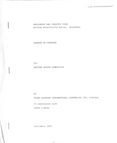
Document - Employment And Industry Study Western Metropolitan Region Summary Of Findings Report, Plant Location International (Australia) Pty Ltd, September 1976
... Plant Location International (Australia) Pty Ltd...City of Sunshine Alexander "Alex" George Gillon Employment And Industry Study Western Metropolitan Region Melbourne Summary of Findings For Western Region Commission Sampled paper report Document Employment And Industry Study Western Metropolitan Region Summary Of Findings Report Plant Location International (Australia) Pty Ltd Loder & Bayley ...Employment And Industry Study Western Metropolitan Region Melbourne Summary of Findings For Western Region Commission city of sunshine, alexander "alex" george gillon -
 Federation University Historical Collection
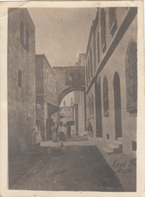
Photograph - Black and White, Chatham-Holmes Collection: House (location unknown)
... Chatham-Holmes Collection: House (location unknown)...Unknown house on the corner of an intersection. Location appears to be in a built-up or city area....Barker Library (top floor) Mount Helen goldfields Unknown house on the corner of an intersection. Location appears to be in a built-up or city area. chatham-holmes collection house Chatham-Holmes Collection: House (location unknown) Photograph - Black and White ...Unknown house on the corner of an intersection. Location appears to be in a built-up or city area.chatham-holmes collection, house -
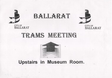 Ballarat Tramway Museum
Poster, City of Ballarat, City of Ballarat, to advise location of meeting, 23 Jan. 1996
... City of Ballarat, to advise location of meeting...A4 size sheet produced by City of Ballarat, to advise location of meeting at Ballarat Town Hall - 23 Jan 1996, 1st public meeting for revival of trams, located in box at foot of stairway. ...City of Ballarat, to advise location of meeting Poster City of Ballarat ...Has a strong association with the move for revival of a trams in Ballarat during the mid 1990's - a notice for a public meeting.A4 size sheet produced by City of Ballarat, to advise location of meeting at Ballarat Town Hall - 23 Jan 1996, 1st public meeting for revival of trams, located in box at foot of stairway. Image of item added 29/9/2013.trams, tramways, ballarat trams, revival, ballarat city tramway, meetings -
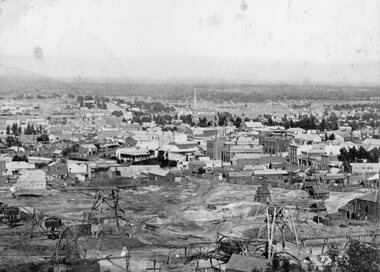 Stawell Historical Society Inc
Photograph, Panorama of Stawell from Big Hill showing Mining & Stawell 1972 from same location -- Christmas Cards with 2 Photos
... Panorama of Stawell from Big Hill showing Mining & Stawell 1972 from same location -- Christmas Cards with 2 Photos...Christmas Card with Photos of Stawell from Big Hill showing Mining 1872 & Stawell 1972 from same location ...Panorama of Stawell from Big Hill showing Mining & Stawell 1972 from same location -- Christmas Cards with 2 Photos Photograph ...Christmas Card with Photos of Stawell from Big Hill showing Mining 1872 & Stawell 1972 from same location View overlooking Main Street. St Matthews Church spire at centre of image.stawell -
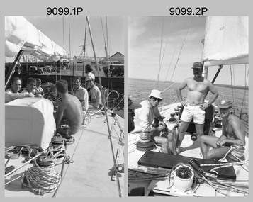
 Bendigo Military Museum
Photograph - Army Survey Regiment – Lithographic Squadron Adventurous Training Set 2, unknown location, 1988
... Army Survey Regiment – Lithographic Squadron Adventurous Training Set 2, unknown location...This is a set of 24 photographs of soldiers from the Army Survey Regiment’s Lithographic Squadron in participating in Ex Eneseay, an adventurous training sailing activity at an unknown location off Australia’s coast in March 1988. ...This is a set of 24 photographs of soldiers from the Army Survey Regiment’s Lithographic Squadron in participating in an adventurous training sailing activity in at an unknown location off Australia’s coast in March 1988. ...Army Survey Regiment – Lithographic Squadron Adventurous Training Set 2, unknown location Photograph Army Survey Regiment – Lithographic Squadron Adventurous Training Set 2, unknown location Army Survey Regiment ...This is a set of 24 photographs of soldiers from the Army Survey Regiment’s Lithographic Squadron in participating in Ex Eneseay, an adventurous training sailing activity at an unknown location off Australia’s coast in March 1988. It is believed ‘Eneseay’ was the name of the yacht. Refer to Item 9099.19P for more photographs taken during this adventurous training activity.This is a set of 24 photographs of soldiers from the Army Survey Regiment’s Lithographic Squadron in participating in an adventurous training sailing activity in at an unknown location off Australia’s coast in March 1988. The black and white photographs are on 35mm negative film and scanned at 2400 dpi. They are part of the Army Survey Regiment’s Collection. .1) - Photo, black & white, 1988. Voyage preparation L to R: Craig Ferguson, Frank Lenane, Damien Cole, Stuart Ridge. .2) - Photo, black & white, 1988. Voyage preparation. .3) - Photo, black & white, 1988. Voyage preparation L to R: Craig Ferguson, Frank Lenane. .4) - Photo, black & white, 1988. Voyage preparation L to R: Craig Ferguson, Frank Lenane, Stuart Ridge. .5) - Photo, black & white, 1988. Voyage preparation L to R: Craig Ferguson, Frank Lenane. .6) - Photo, black & white, 1988. Voyage preparation L to R: Unidentified, unidentified scuba diver. .7) - Photo, black & white, 1988. Voyage preparation L to R: Craig Ferguson, Frank Lenane. .8) - Photo, black & white, 1988. L to R: Unidentified civilian, Rob Bogumil. .9) - Photo, black & white, 1988. L to R: Stuart Ridge, unidentified civilian, Lance Strudwick. .10) - Photo, black & white, 1988. L to R: Damien Cole, Stuart Ridge, unidentified civilian, Lance Strudwick. .11) - Photo, black & white, 1988. L to R: Damien Cole, Frank Lenane. .12) - Photo, black & white, 1988. Rob Bogumil. .13) - Photo, black & white, 1988. L to R: Colin Campbell, unidentified (x2), Craig Ferguson. .14) - Photo, black & white, 1988. L to R: Colin Campbell, unidentified, Craig Ferguson, Damien Cole. .15) - Photo, black & white, 1988. Frank Lenane. .16) - Photo, black & white, 1988. Unidentified civilian. .17) & .18) - Photo, black & white, 1988. Rob Bogumil. .19) - Photo, black & white, 1988. Craig Ferguson. .20) - Photo, black & white, 1988. Stuart Ridge, Peter Barrett. .21) - Photo, black & white, 1988. Lance Strudwick. .22) - Photo, black & white, 1988. L to R: Rob Bogumil, Damien Cole, unidentified civilian, Colin Campbell. .23) - Photo, black & white, 1988. L to R: Damien Cole, Craig Ferguson, unidentified civilian, Colin Campbell, Frank Lenane. .24) - Photo, black & white, 1988. L to R: Damien Cole, Craig Ferguson, unidentified civilian, Frank Lenane, Colin Campbell. There are no personnel identified. ‘Litho Sqn Adventure Trg Eneseay Mar 1988’ annotated on negative sleeve.royal australian survey corps, rasvy, army survey regiment, army svy regt, fortuna, litho, litho sqn -
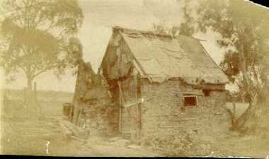 Greensborough Historical Society
Photograph - Digital image, Unidentified location, possibly Healesville, 1880c
... Unidentified location, possibly Healesville....Hut, unidentified location, possibly Healesville. Photograph found by Peter Blackbourn in a miner's cottage, in Healesville, in 1974. ...Greensborough Historical Society 34A Glenauburn Road Lower Plenty Lower Plenty melbourne Hut, unidentified location, possibly Healesville. Photograph found by Peter Blackbourn in a miner's cottage, in Healesville, in 1974. ...Hut, unidentified location, possibly Healesville. Photograph found by Peter Blackbourn in a miner's cottage, in Healesville, in 1974. Photographs from the collection of Peter Blackbourn, a descendant of the Chapman Stock family. Annotations to photos by Peter Blackbourn.Digital copy of black and white photograph.peter blackbourn