Showing 370 items matching "location plan"
-
 Stawell Historical Society Inc
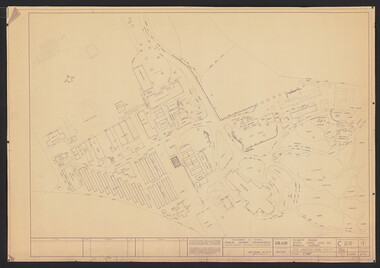
Map, Western Mining Corporation Limited, Shaft Location Plan April 1981, 1981
... Western Mining Corporation Limited, Shaft Location Plan April 1981...Western Mining Corporation Ltd Shaft Location Plan 1981 Very Large Plot Showing Contours and Streets Without names. ...Sheet 1 0f 2 Western Mining Corporation Limited, Shaft Location Plan April 1981 Map ...Western Mining Corporation Ltd Shaft Location Plan 1981 Very Large Plot Showing Contours and Streets Without names. Sheet 1 0f 2 stawell, mining -
Stawell Historical Society Inc
Map, Western Mining Corporation Ltd Shaft Location Plan 1981, 1981
... Western Mining Corporation Ltd Shaft Location Plan 1981 ... Western Mining Corporation Ltd Shaft Location Plan 1981 Very Large Plot Showing Contours and Streets Without names. ...Sheet 2 0f 2 Western Mining Corporation Ltd Shaft Location Plan 1981 Map ...Western Mining Corporation Ltd Shaft Location Plan 1981 Very Large Plot Showing Contours and Streets Without names. Sheet 2 0f 2 stawell, mining -
 University of Melbourne, Burnley Campus Archives
Plan, M. Drake et al, Incubator Building and Random Sample Laying Test Burnley Gardens - Site Location Plan, 1967
... Incubator Building and Random Sample Laying Test Burnley Gardens - Site Location Plan...Incubator Building and Random Sample Laying Test Burnley Gardens - Site Location Plan Plan M. Drake R. G. Wilson ...Plan by Public Works Dept., Melbourne. M. Drake (draughtsman), R. G. Wilson, Chief Architect.Copy 2 has some pencil additionsm. drake, g.r. wilson, burnley gardens, buildings, victoria public works department -
 Friends of Ballarat Botanical Gardens History Group
Map - Map of Trees in the Ballarat Botanical Gardens, Tree Research - Location Plan and Naming, 1983
... Tree Research - Location Plan and Naming, 1983....Friends of Ballarat Botanical Gardens History Group George Longley Building Gillies Street North entrance Ballarat West 3350 John Garner Collection Ballarat Botanical Gardens Gardens Ballarat Trees map 1983 Tree Research - Location Plan and Naming, 1983. Map Map of Trees in the Ballarat Botanical Gardens. ...john garner collection, ballarat botanical gardens, gardens, ballarat, trees, map, 1983 -
 Flagstaff Hill Maritime Museum and Village
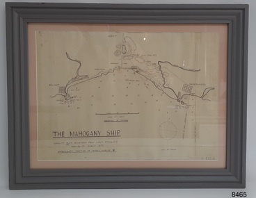
Document - Location Chart, The Mahogany Ship, 2007
... ...location plan...The identity of the vessel has the potential to change Australia’s history. warrnambool shipwrecked coast flagstaff hill maritime museum shipwreck coast mahogany ship ancient vessel ancient wreck portuguese ship Coastal Reserve fabled wreck gold ship Griffiths Island Belfast (now Port Fairy) Koroit location plan Leuit. Stanley Admiralty Chart 1872 Tower Hill Merri River Moyne River Middle Island Helen Rock Armstrong Bay Griffiths Land Lower left: "THE MAHOGANY SHIP" "LOCALITY PLAN, ENLARGED FROM LIEUT. ...This chart shows a possible site for the fabled wreck called the 'Mahogany Ship'. Flagstaff Hill’s collection includes other objects that some say could be relics from this Ancient Wreck, (also called the Gold Ship, or the Ancient Vessel). The chart shows the coordinates for the Summits of Griffith Island and of Middle Island. It also has the depths of the sea at various intervals and shows the shore and sand dunes, lighthouses and other reference points. The mystery of the Mahogany Ship began in 1836 when two shipwrecked sealers discovered the remains of an “ancient vessel” in the sand dunes about four miles west of Warrnambool. Since the last recorded sightings in the 1880’s the true origin of the Mahogany Ship has remained one of Australia’s most famous historical mysteries or fables. One of the more recent theories is that the vessel was one of the Portuguese ships exploring the Australian coast in 1522. For over one hundred years searchers have attempted to locate and identify the wreck. The search continues for the tangible evidence which will once and for all establish the Mahogany Ship’s place in Australia’s History.The chart represents the worldwide interest in locating the wreck of the Mahogany Ship. Locating the actual wreck or proving the existence of a Portuguese ship's wreck could change the history of the discovery of Australia. A Mahogany Ship committee was formed to gather and research information about the discovery of the wrecked ship. A large amount of money was offered as a prize for finding the wreck or parts of it. People have written books, painted images, made videos and told tales of the ship but it continues to remain a mystery or even a fable. The chart is significant for its possible link to one of Victoria’s and Australia’s maritime mysteries, the Mahogany Ship (also known as the Ancient Wreck). It is one of very few known relics that could give evidence of the existence and history of the vessel. It is listed on the Victorian Heritage Register S438 as it is one of Victoria’s oldest recorded shipwrecks. The identity of the vessel has the potential to change Australia’s history.A chart in a wooden frame, behind glass. The chart shows the approximate position of the mystery Ancient Wreck, later called the "Mahogany Ship". The chart is a copy and is based on the Admiralty Chart by Lieut. Stanley, dated 1872. Lower left: "THE MAHOGANY SHIP" "LOCALITY PLAN, ENLARGED FROM LIEUT. STANLEY'S ADMIRALTY CHART 1872" "APPROXIMATE POSITION OF WRECK MARKED [symbol of a Portuguese cross]" Other labels on chart: "BELFAST" "PORT FIARY" "GRIFFITHS I" "RIVER MOYNE" "RIVER MERRI" "ARMSTRONG BAY" " GORMANS LANE" "TOWER HILL" "KOROIT" "HELEN ROCK" "WARRNAMBOOL" "LADY BAY" "MIDDLE I" "LIGHT HO." Lower right: "G 410 B" Label on the back; "This chart presented to the Mahogany Ship Committee and Flagstaff Hill by Avis Quarrell, April 2007"warrnambool, shipwrecked coast, flagstaff hill maritime museum, shipwreck coast, mahogany ship, ancient vessel, ancient wreck, portuguese ship, coastal reserve, fabled wreck, gold ship, griffiths island, belfast (now port fairy), koroit, location plan, leuit. stanley, admiralty chart 1872, tower hill, merri river, moyne river, middle island, helen rock, armstrong bay, griffiths land -
Federation University Historical Collection
Plan, Ballarat Plan Showing Ballarat School of Mines Campuses
... ...Location plan...A3 plan showing the location of Ballarat School of Mines Campuses,...Barker Library (top floor) Mount Helen goldfields Ballarat School of Mines Location plan Hickman Street Community Resource centre brick laying school rural studies centre Ballarat school of Mines boat shed Barkly Street Lake Bolac TAFE Centre A3 plan showing the location of Ballarat School of Mines Campuses, Ballarat Plan Showing Ballarat School of Mines Campuses Plan ...A3 plan showing the location of Ballarat School of Mines Campuses,ballarat school of mines, location plan, hickman street, community resource centre, brick laying school, rural studies centre, ballarat school of mines boat shed, barkly street, lake bolac tafe centre -
Port Melbourne Historical & Preservation Society
Plan - Port Melbourne Yacht Club reconstruction, Taylor Howden Pty Ltd, Architects, c. 1990
... Plan of Port Melbourne Yacht Club clubhouse reconstruction 1990 - PMYC site and location plan; faded almost to illegibility...Port Melbourne Historical & Preservation Society Port Melbourne Town Hall 333 Bay Street Port Melbourne melbourne Clubhouse burned 14 February 1990 and was rebuilt with volunteer labour over many years (opened 1998) built environment - recreational facilities societies clubs unions and other organisations port melbourne yacht club pmyc taylor howden pty ltd Plan of Port Melbourne Yacht Club clubhouse reconstruction 1990 - PMYC site and location plan; faded almost to illegibility Plan Port Melbourne Yacht Club reconstruction Taylor Howden Pty Ltd, Architects ...Clubhouse burned 14 February 1990 and was rebuilt with volunteer labour over many years (opened 1998)Plan of Port Melbourne Yacht Club clubhouse reconstruction 1990 - PMYC site and location plan; faded almost to illegibilitybuilt environment - recreational facilities, societies clubs unions and other organisations, port melbourne yacht club, pmyc, taylor howden pty ltd -
 Ringwood and District Historical Society
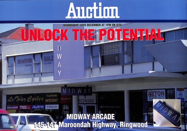
Administrative record - Auction Documents, Midway Arcade, 145-147 Maroondah Highway, Ringwood - December 1997
... Report contents include site details, tenancy details, terms of sale, location plan and copy of certificiate of title. ...Ringwood and District Historical Society 125A Warrandyte Road Ringwood North melbourne Report contents include site details, tenancy details, terms of sale, location plan and copy of certificiate of title. ...Soft covered wire-bound 25-page booklet and double-sided auction brochure announcing sale by Public Auction of Midway Arcade on Wednesday 10th December (1997).Report contents include site details, tenancy details, terms of sale, location plan and copy of certificiate of title. Conjunctional agents - Fitzroys Pty Ltd, 367 Collins Street, Melbourne; C.E. Carter & Son Pty Ltd, 128 MaroondahHighway, Ringwood, (Tel) 9870 6211. -
 Robin Boyd Foundation
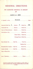
Document, Assorted documents, Jul-61
... Documentation for Wall Niche with cast bronze memorial plate for Edith Susan Gerard Boyd (16 Feb 1880 - 31 Mar 1961), Robin Boyd's mother at Springvale Cemetery - includes a location plan, invoice and receipts....Robin Boyd Foundation 290 Walsh Street South Yarra melbourne Documentation for Wall Niche with cast bronze memorial plate for Edith Susan Gerard Boyd (16 Feb 1880 - 31 Mar 1961), Robin Boyd's mother at Springvale Cemetery - includes a location plan, invoice and receipts. 5 documents Assorted documents Document ...Documentation for Wall Niche with cast bronze memorial plate for Edith Susan Gerard Boyd (16 Feb 1880 - 31 Mar 1961), Robin Boyd's mother at Springvale Cemetery - includes a location plan, invoice and receipts.5 documents -
Tatura Irrigation & Wartime Camps Museum
Document, Geological Plan, Eildon Dam Site, 1945
... A series of maps illustrating rock formations etc., locations, boundaries and plans...Tatura Irrigation & Wartime Camps Museum 49 Hogan Street Tatura the-murray To record details of geological aspects of Eildon water/irrigation documents maps A series of maps illustrating rock formations etc., locations, boundaries and plans Geological Plan, Eildon Dam Site Document ...To record details of geological aspects of EildonA series of maps illustrating rock formations etc., locations, boundaries and planswater/irrigation, documents, maps -
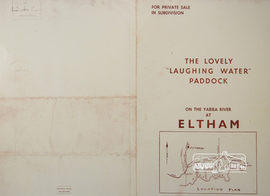 Eltham District Historical Society Inc
Photograph, For Private Sale in Subdivisions; The Lovely "Laughing Water" Paddock on the Yarra River at Eltham
... Sole Agent: Edward Haughton, 379 Collins Street, Melbourne Location plan and subdivision map...Sole Agent: Edward Haughton, 379 Collins Street, Melbourne Location plan and subdivision map laughing waters edward haughton real estate agent eltham A3 colour photographic print from digital image of sales brochure and A4 reproduction of price list For Private Sale in Subdivisions; The Lovely "Laughing Water" Paddock on the Yarra River at Eltham. ...Private sale of the "Laughing Water" paddock in subdivision; 5 river frontages with weatherboard villa on Lot 8; 6 woodland blocks of 5 and 6 acres. Sole Agent: Edward Haughton, 379 Collins Street, Melbourne Location plan and subdivision mapA3 colour photographic print from digital image of sales brochure and A4 reproduction of price listlaughing waters, edward haughton, real estate agent, eltham -
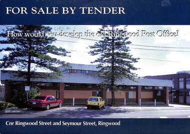 Ringwood and District Historical Society
Flyer - Sale by Tender, Corner Development Site, Cnr Ringwood Street and Seymour Street - Ringwood. 1988
... Site coloured red in location plan which also includes New Street, Bond Street, Charter Street, Seymour Street, Ringwood Street, Ringwood Bypass, Maroondah Highway, Eastland Shopping Centre, Ringwood Market and Ringwood Square....Site coloured red in location plan which also includes New Street, Bond Street, Charter Street, Seymour Street, Ringwood Street, Ringwood Bypass, Maroondah Highway, Eastland Shopping Centre, Ringwood Market and Ringwood Square. ...Double-sided advertisement with full colour street view of former Ringwood Post Office opposite Eastland Shopping Centre and adjacent to Ringwood Market Shopping Centre. Site coloured red in location plan which also includes New Street, Bond Street, Charter Street, Seymour Street, Ringwood Street, Ringwood Bypass, Maroondah Highway, Eastland Shopping Centre, Ringwood Market and Ringwood Square.Former Post Office and vacant land, total area 2397 sqm approx. 2 level former Post Office Ground 520 sqm, first 150 sqm. Tenders close April 30, 1998 at 5pm. Agents - Finch Freeman 356 Collins Street, Melbourne, Tel. 96060600. Contacts - Ian Dungey 0411749756, Philip Soumilas 0418328159. -
 Ringwood and District Historical Society
Flyer - Auction Wednesday 23rd November (1994 ?), Ringwood Central, 93-97 Maroondah Highway, Ringwood
... Blocks for auction coloured red in location plan which also includes New Street, Bond Street, Market Street, Seymour Street, Maroondah Highway, Eastland Shopping Centre, Ringwood Market, Target, and ANZ Bank. ...Blocks for auction coloured red in location plan which also includes New Street, Bond Street, Market Street, Seymour Street, Maroondah Highway, Eastland Shopping Centre, Ringwood Market, Target, and ANZ Bank. ...Double-sided advertisement with full colour aerial and street views of retail development sites fronting Maroondah Highway backing onto Seymour Street, and additional car park area at corner of Charter and Market Streets, Ringwood. Blocks for auction coloured red in location plan which also includes New Street, Bond Street, Market Street, Seymour Street, Maroondah Highway, Eastland Shopping Centre, Ringwood Market, Target, and ANZ Bank. Land area: Maroondah Highway 8,347 sq/m. Charter Street 2,400 sq/m. Current Income: $515,355 p.a. (gross) approx. Tenants include Jooce Nightclub, World Gym, Timezone and Fast Break. Note: All tenancies expire by 6/98. Agents: Colliers Jardine, 541 Blackburn Road, Waverley, Tel. 544 8888, Nick Bourke AH: 818 7139. -
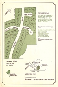 Ringwood and District Historical Society
Flyer, Land Sale Advertisement - Banool Gardens Subdivision, Ringwood, Vic. c.1985
... Double-sided advertisement for Banool Gardens subdivision with site plan, location plan, terms of sale, and summary of homesite features and local services & facilities. ...Double-sided advertisement for Banool Gardens subdivision with site plan, location plan, terms of sale, and summary of homesite features and local services & facilities. ...Double-sided advertisement for Banool Gardens subdivision with site plan, location plan, terms of sale, and summary of homesite features and local services & facilities. Subdivision includes Wonga Road, Hamilton Drive, Tinworth Place, Andrea Parade and Benjamin Court, Ringwood North. Managing agent - Ollson Real Estate Pty. Ltd., North Croydon Shopping Plaza, Maroondah Highway. Croydon, Vic. 3136. Telephone 726 9988 After Hours 876 4190. Project by Darnley Developments (Vic.) Pty. Ltd. Accompanying handwritten notation by Richard Carter R.E.S.I. - "Part of original Banool property (Mahon, sold to Stallman, sold to McMahon, sold to Len Macley etc etc). Hamilton Drive named after Lynn Hamilton McMahon, Tinworth Place after his son-in-law, David Tinworth". -
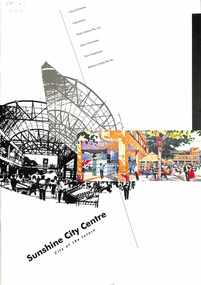 Sunshine and District Historical Society Incorporated
Document - Sunshine City Centre City of the future
... Sunshine City Centre City of the Future|City Square perspective|Retail Market perspective|Location plans & study areas|Household income & expenditure relationships|Forecast household growth|Strategic issues plan|Draft Structure pland|Traffic management plan New retial centre plan|Landscape masterplan|Hampshire Walk perspective|Station Square perspective|City Square precinct plan|Hampshire Walk Precinct plan|Hampshire Walk prespective 2|Station Square precinct plan|Station Sqaure concept plan|Sun Crescent precint plan|Sun Crescent prespective|Devonshire Road Offices perspective...Sunshine City Centre Sunshine City Centre City of the Future|City Square perspective|Retail Market perspective|Location plans & study areas|Household income & expenditure relationships|Forecast household growth|Strategic issues plan|Draft Structure pland|Traffic management plan New retial centre plan|Landscape masterplan|Hampshire Walk perspective|Station Square perspective|City Square precinct plan|Hampshire Walk Precinct plan|Hampshire Walk prespective 2|Station Square precinct plan|Station Sqaure concept plan|Sun Crescent precint plan|Sun Crescent prespective|Devonshire Road Offices perspective Large colored report with proposals of the future of the Sunshine Shopping Centre Document Sunshine City Centre City of the future ...Sunshine City Centre City of the Future|City Square perspective|Retail Market perspective|Location plans & study areas|Household income & expenditure relationships|Forecast household growth|Strategic issues plan|Draft Structure pland|Traffic management plan New retial centre plan|Landscape masterplan|Hampshire Walk perspective|Station Square perspective|City Square precinct plan|Hampshire Walk Precinct plan|Hampshire Walk prespective 2|Station Square precinct plan|Station Sqaure concept plan|Sun Crescent precint plan|Sun Crescent prespective|Devonshire Road Offices perspectivesunshine city centre -
 Melbourne Tram Museum
Document - Report, Melbourne & Metropolitan Tramways Board (MMTB), "Tramcar Sound Levels - External", 30/03/1950 12:00:00 AM
... Includes various classes of trams (including W3 and W4 class trams), appendices with sound levels, location plan for testing. Testing done on ballasted track in St Georges Road. ...Includes various classes of trams (including W3 and W4 class trams), appendices with sound levels, location plan for testing. Testing done on ballasted track in St Georges Road. ...Report - typed carbon copy - 31 foolscap sheets with three graphs and drawings within a brown card folder bound with adhesive tape and fold back clips. Titled "Tramcar Sound Levels - External", dated 30/3/1950, prepared by the MMTB Testing Department, Report No. N1/1/38. Gives details of the purpose of the test, procedures, results, discussion and conclusions. Includes various classes of trams (including W3 and W4 class trams), appendices with sound levels, location plan for testing. Testing done on ballasted track in St Georges Road. Signed by D. H. Eakins. Two copies held.trams, tramways, preston workshops, reports, specification, wheels, tramcars, track, noise -
 Melbourne Tram Museum
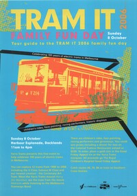
Pamphlet, Yarra Trams, "Tram It 2006 - Family Fun Day - Sunday 8 October - your guide to the Tram It family fun day", Oct. 2006
... On the rear has a map of the event and location plan. Two copies held....On the rear has a map of the event and location plan. Two copies held. "Tram It 2006 - Family Fun Day - Sunday 8 October - your guide to the Tram It family fun day" Pamphlet Yarra Trams ...Full colour pamphlet folded A3 printed on gloss paper titled "Tram It 2006 - Family Fun Day - Sunday 8 October - your guide to the Tram It family fun day", advertising the Yarra Trams event at Docklands on 8/10/2006 to celebrate 100 years of electric trams in Melbourne. Has an image of V214, event details and planning. Has the Yarra Trams 100 years logo and their logo and the City of Melbourne logo along the bottom of sheet. Inside lists the 11 trams to appear at the event along with details of each tram or class of tram, with a reversed colour image. On the rear has a map of the event and location plan. Two copies held.trams, tramways, yarra trams, 100 years of electric trams, docklands, displays, tramcars, v class, htt, w class, w5 class, vr, w7 class, z class, a class, b class, c class, d class -
 Ringwood and District Historical Society
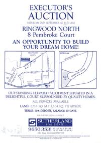
Flyer, Auction - 8 Pembroke Court, Ringwood North, Victoria - 1995
... A4 size advertisement for executor's auction of residential property with site plan and location map. Auction date Saturday 2nd September (1995)....A4 size advertisement for executor's auction of residential property with site plan and location map. Auction date Saturday 2nd September (1995). ...A4 size advertisement for executor's auction of residential property with site plan and location map. Auction date Saturday 2nd September (1995).Outstanding elevated allotment situated in a delightful court surrounded by quality homes. All services available. Land: 1,255 Sq.m. (13,504 Sq.m.) approx. Terms: 10% deposit, balance 60 days. Agent - Sutherland Real Estate, 43 Agnes Street, East Melbourne (Telephone) 9650 3531. -
 University of Melbourne, Burnley Campus Archives
Plan, VCAH -Burnley: Sluice Valve, Tap & Fire Hydrant Locations, c. 1987
... Plan showing locations and instructions for use, hand drawn. ...VCAH -Burnley: Sluice Valve, Tap & Fire Hydrant Locations Plan ...Plan showing locations and instructions for use, hand drawn. "Overlay onto SP1 Plan 1/1987," handwritten on it. Plan same as 11.0715.vcah, sluice valves, taps, fire hydrants -
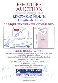 Ringwood and District Historical Society
Flyer, Auction - 1 Hearthside Court, Ringwood North, Victoria - 1995
... A4 size advertisement for executor's auction of 1.73 acre property with site plan and location map. Auction date Saturday 2nd September (1995)....A4 size advertisement for executor's auction of 1.73 acre property with site plan and location map. Auction date Saturday 2nd September (1995). ...A4 size advertisement for executor's auction of 1.73 acre property with site plan and location map. Auction date Saturday 2nd September (1995).Prime residential site. Ideal for redevelopment or subdivision in the heart of this well established residential suburb. Existing older style two bedroom aluminium clad dwelling. Currently let $145 per week. Land: 6,980 Sq.m. (1.73 acres) approx. Zoning: Residential C. Terms: 10% deposit, balance 60 days. Agent - Sutherland Real Estate, 43 Agnes Street, East Melbourne (Telephone) 9650 3531. -
Port Melbourne Historical & Preservation Society
Plan - Port Melbourne Yacht Club, John Adam, Architect, 1960s
... Plans for Port Melbourne Yacht Club new dinghy building 1962. .01 Storage layouts - sketch plan .02 Plan of new dinghy building .03 Location and pile plan .04 Working drawing - site elevations .05 Working drawing - plan view ...Port Melbourne Historical & Preservation Society Port Melbourne Town Hall 333 Bay Street Port Melbourne melbourne Sport - Yachting Built Environment - Recreational facilities Plans for Port Melbourne Yacht Club new dinghy building 1962. .01 Storage layouts - sketch plan .02 Plan of new dinghy building .03 Location and pile plan .04 Working drawing - site elevations .05 Working drawing - plan view Plan Port Melbourne Yacht Club John Adam, Architect ...Plans for Port Melbourne Yacht Club new dinghy building 1962. .01 Storage layouts - sketch plan .02 Plan of new dinghy building .03 Location and pile plan .04 Working drawing - site elevations .05 Working drawing - plan view sport - yachting, built environment - recreational facilities -
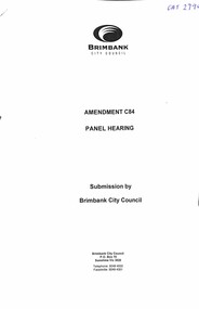 Sunshine and District Historical Society Incorporated
Document - Brimbank Heritage Study Amendment C.84 Panel Hearings 2007
... Brimbank Heritage Study Amendment C.84|Panel Hearings Aug 2007|Documents Submitted|Brimbank City Council Post-contact Cultural Heritage Strategy Stage 1 - Preliminary Survey by Olwen Ford & Gary Vines|Brimbank City Council Post-contact Cultural Heritage Strategy Volume 3 - Place Report Heritage Areas and Individual Places Gary Vine|McKay Housing Site Locations|Maribyrnong Planning Scheme Heritage Overlay|Heritage Plan|Heritage Places in City of Brimbank 2099...City of Brimbank Brimbank Heritage Study Amendment C.84|Panel Hearings Aug 2007|Documents Submitted|Brimbank City Council Post-contact Cultural Heritage Strategy Stage 1 - Preliminary Survey by Olwen Ford & Gary Vines|Brimbank City Council Post-contact Cultural Heritage Strategy Volume 3 - Place Report Heritage Areas and Individual Places Gary Vine|McKay Housing Site Locations|Maribyrnong Planning Scheme Heritage Overlay|Heritage Plan|Heritage Places in City of Brimbank 2099 Collection of documents on the Brimbank Heritage Study Document Brimbank Heritage Study Amendment C.84 Panel Hearings 2007 ...Brimbank Heritage Study Amendment C.84|Panel Hearings Aug 2007|Documents Submitted|Brimbank City Council Post-contact Cultural Heritage Strategy Stage 1 - Preliminary Survey by Olwen Ford & Gary Vines|Brimbank City Council Post-contact Cultural Heritage Strategy Volume 3 - Place Report Heritage Areas and Individual Places Gary Vine|McKay Housing Site Locations|Maribyrnong Planning Scheme Heritage Overlay|Heritage Plan|Heritage Places in City of Brimbank 2099city of brimbank -
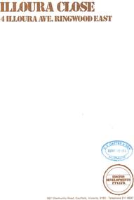 Ringwood and District Historical Society
Document - Sales Brochure, "Illoura Close" 4 Illoura Avenue, Ringwood East, Victoria. Circa 1970s
... Folded brochure advertising sale of ten Group Housing Project properties, with list of features, site plan, location map, and typewritten summary of house sizes and prices. ...Folded brochure advertising sale of ten Group Housing Project properties, with list of features, site plan, location map, and typewritten summary of house sizes and prices. ...Folded brochure advertising sale of ten Group Housing Project properties, with list of features, site plan, location map, and typewritten summary of house sizes and prices. Edston Developments Pty. Ltd., 967 Glenhuntly Road Caulfield, Victoria, 3162. Telephone 211 6937. Architects: Clive Fredman and John Malina - 880 Toorak Road, East Hawthorn. Accompanying handwritten notation by Richard Carter R.E.S.I. - "Illoura Close (is) one of the few developments in Ringwood under the Cluster Titles Act". -
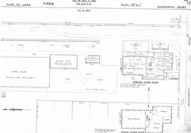 Melbourne Tram Museum
Drawing, Melbourne & Metropolitan Tramways Board (MMTB), "Glenhuntly Depot", c1937
... Set of three photocopied plans or drawings on A3 sheet of "Glenhuntly Depot" - c 1938 .1 - P8334 - Plan of land showing details of offices and tennis court - 2-6-1938 .2 - P8335 - Plan of land showing car depot layout and associated buildings - 2-6-1938 - shows substation location. .3 - P8333 - Plan of land showing MMTB land and surrounding properties. - 2-6-1938...Melbourne Tram Museum 8 Wallen Road Hawthorn melbourne Trams tramways Drawings Depots Property Glenhuntly Tram Depot Substation Set of three photocopied plans or drawings on A3 sheet of "Glenhuntly Depot" - c 1938 .1 - P8334 - Plan of land showing details of offices and tennis court - 2-6-1938 .2 - P8335 - Plan of land showing car depot layout and associated buildings - 2-6-1938 - shows substation location. .3 - P8333 - Plan of land showing MMTB land and surrounding properties. - 2-6-1938 "Glenhuntly Depot" Drawing Melbourne & Metropolitan Tramways Board (MMTB) ...Set of three photocopied plans or drawings on A3 sheet of "Glenhuntly Depot" - c 1938 .1 - P8334 - Plan of land showing details of offices and tennis court - 2-6-1938 .2 - P8335 - Plan of land showing car depot layout and associated buildings - 2-6-1938 - shows substation location. .3 - P8333 - Plan of land showing MMTB land and surrounding properties. - 2-6-1938trams, tramways, drawings, depots, property, glenhuntly tram depot, substation -
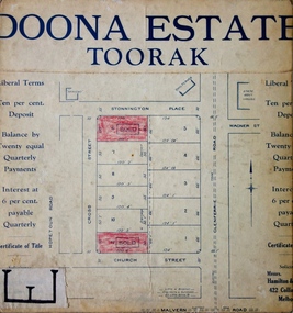 Kew Historical Society Inc
Plan - Subdivision Plan, Doona Estate, Toorak, 1929
... On the right of the plan, the location of ‘State Govt. House’ is noted. ...On the right of the plan, the location of ‘State Govt. House’ is noted. ...The Kew Historical Society collection includes almost 100 subdivision plans pertaining to suburbs of the City of Melbourne. Most of these are of Kew, Kew East or Studley Park, although a smaller number are plans of Camberwell, Deepdene, Balwyn and Hawthorn. It is believed that the majority of the plans were gifted to the Society by persons connected with the real estate firm - J. R. Mathers and McMillan, 136 Cotham Road, Kew. The Plans in the collection are rarely in pristine form, being working plans on which the agent would write notes and record lots sold and the prices of these. The subdivision plans are historically significant examples of the growth of urban Melbourne from the beginning of the 20th Century up until the 1980s. A number of the plans are double-sided and often include a photograph on the reverse. A number of the latter are by noted photographers such as J.E. Barnes.The Doona Estate subdivision of 1929 created 11 new allotments bordered by Glenferrie Road, Stonnington Place, Cross and Church Streets. On the right of the plan, the location of ‘State Govt. House’ is noted. Stonnington was to be maintained as Victoria’s Government House until 1931, two years after the Doona Estate subdivision was released.subdivision plans - toorak, doona estate -
 Melbourne Tram Museum
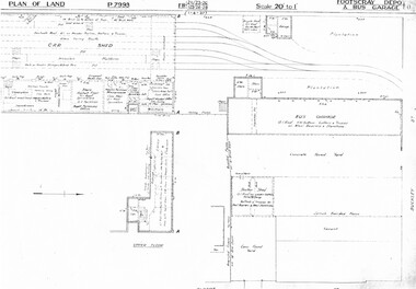
Drawing, Melbourne & Metropolitan Tramways Board (MMTB), "Footscray Depot and bus garage", c1937
... Set of three photocopied plans or drawings on A3 sheet of "Footscray Depot and bus garage" c 1937 .1 - P7993 - Plan of land showing car shed, bus garage and offices dated 1-4-1937 - shows substation location. .2 - P? ...Melbourne Tram Museum 8 Wallen Road Hawthorn melbourne Trams tramways Drawings Depots Property Footscray Depot Substation Set of three photocopied plans or drawings on A3 sheet of "Footscray Depot and bus garage" c 1937 .1 - P7993 - Plan of land showing car shed, bus garage and offices dated 1-4-1937 - shows substation location. .2 - P? ...Set of three photocopied plans or drawings on A3 sheet of "Footscray Depot and bus garage" c 1937 .1 - P7993 - Plan of land showing car shed, bus garage and offices dated 1-4-1937 - shows substation location. .2 - P? - Plan of land showing buildings and surrounding properties - dated 1-4-1937 .3 - P79821 - ditto but a wider area - dated 1-4-1937 - shows substation location.trams, tramways, drawings, depots, property, footscray depot, substation -
 Bendigo Historical Society Inc.
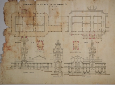
Plan - MARKS COLLECTION: PLAN FOR FOUR LEVEL STAIRCASE TOWER TO GARDEN ELEVATION AT FORTUINA VILLA FOR GEO. LANSELL ESQ
... Plan details: * Plan shows ground, First, second and third floor plans for the staircase construction * First and second floor house plans and location of staircase addition * Front and Garden elevations with staircase addition Plan coloured and damaged on LHS, also with water damage...Plan details: * Plan shows ground, First, second and third floor plans for the staircase construction * First and second floor house plans and location of staircase addition * Front and Garden elevations with staircase addition Plan coloured and damaged on LHS, also with water damage Plan MARKS COLLECTION: PLAN FOR FOUR LEVEL STAIRCASE TOWER TO GARDEN ELEVATION AT FORTUINA VILLA FOR GEO. ...Fortuna Villa was owned from 1855 to 1871 by Christopher and Theodore Ballerstedt, Australia’s first mining magnates. In 1871 it was purchased by George Lansell (The Quartz King) being one of Australia’s most successful and adventurous nineteenth century gold mine owners and speculators. Lansell made numerous alterations and extensions to the building and it remained in the Lansell family until 1935.Plan for four level staircase tower to the Garden Elevation of Fortuna Villa, Sandhurst for George Lansell Esq. Plan details: * Plan shows ground, First, second and third floor plans for the staircase construction * First and second floor house plans and location of staircase addition * Front and Garden elevations with staircase addition Plan coloured and damaged on LHS, also with water damagebendigo fortuna villa, george lansell, building plans, c & t ballerstedt -
 Bendigo Historical Society Inc.
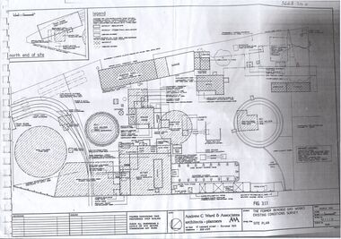
Plan - Bendigo Gasworks, Unknown
... Ward & Associates, architects and planners. Plan shows location of all items of plant in the Gas Works 2. ...Ward & Associates, architects and planners. Plan shows location of all items of plant in the Gas Works 2. ...The Bendigo Gas Works are one of around three remaining intact 19th century gas works in the world, and the only one in Australia. It is on the Victorian Heritage Register and regarded by Institution of Engineers Australia as an internationally significant example of an entire provincial gasworks The Bendigo Gasworks operated from 1860 until 1973 when natural gas was introduced and remain as they were at the time of closure; a treasure of industrial heritage frozen in time. It is an internationally significant example of an entire provincial gasworks. It has the only horizontal gas-producing retorts in Australia. Coal Gas was manufactured here from 1860 and operated continuously until the introduction of natural gas in 1973. The works were operated by the Bendigo Gas Company until purchased by the Gas and Fuel Corporation in 1958 at which time they were supplying 3,500 consumers. During the Second World War the works were expanded by the Ministry of Munitions to serve the Bendigo Ordinance Factory. The original works were constructed during 1859-1860 under the direction of engineer Alexander Kennedy Smith (1824 - 1881) and developed in a period of growth by W. A. Simco, General Manager 1922-1939. ( Engineering Heritage Australia: ttps://heritage.engineersaustralia.org.au/wiki/Place:Bendigo_Gas_Works) The site is on the Victorian Heritage Register (VHR) Number H0781 1. One page A3 photocopy of site plan of the former Bendigo Gas Works Existing Conditions Survey, by Andrew C. Ward & Associates, architects and planners. Plan shows location of all items of plant in the Gas Works 2. One page photocopy, headed 'Functional Arrangement of Plant' showing the major functional items of plant, machinery and equipment at the Bendigo Gasworks for the period 1930 - 1965. sandhurst, bendigo, gas works, heritage listing, tourism, science and engineering, bendigo city council, retort -
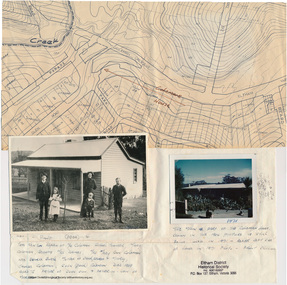 Eltham District Historical Society Inc
Folder, Colemans Corner, Eltham
... (Photo retrieved by Harry Gilham from from a 1972 'time capsule bucket' found at the Eltham Shire Office during its demolition in July-August 1996 (See also SEPP_0745 and 1678A) Photo of "Coleman's house", 1971 Survey plan showing location of Coleman's house...(Photo retrieved by Harry Gilham from from a 1972 'time capsule bucket' found at the Eltham Shire Office during its demolition in July-August 1996 (See also SEPP_0745 and 1678A) Photo of "Coleman's house", 1971 Survey plan showing location of Coleman's house bus services wattletree road bridge coleman family coleman's corner harry gilham collection HG Booklet 9 Folder of information and photos relating to the Colemans Corner precinct located on the corner of Main Road and Wattletree Road, Eltham. ...Letter from Nillumbik Council to H.Gilham in response to consultation on Wattletree Road Bridge replacement, 13 August 2007, 1p. VicRoads brochure on Wattletree Road bridge replacement project, August 2007, 1p Photo of "Coleman's house", 1904 with brief family history. (Photo retrieved by Harry Gilham from from a 1972 'time capsule bucket' found at the Eltham Shire Office during its demolition in July-August 1996 (See also SEPP_0745 and 1678A) Photo of "Coleman's house", 1971 Survey plan showing location of Coleman's houseFolder of information and photos relating to the Colemans Corner precinct located on the corner of Main Road and Wattletree Road, Eltham. HG Booklet 9bus services, wattletree road bridge, coleman family, coleman's corner, harry gilham collection -
 Port Melbourne Historical & Preservation Society
Plan - Edwards Park improvements (Trugo Green), Port Melbourne, 1940s - 1950s
... PMHPS does to believe the basketball court shown in the plan was built but the Port Melbourne Senior Citizens and Trugo Club is at the location shown on the plan. ...PMHPS does to believe the basketball court shown in the plan was built but the Port Melbourne Senior Citizens and Trugo Club is at the location shown on the plan. ...Although undated, this plan is probably from the late 1940s or early 1950s. Around this time Port Melbourne Council were looking to built a basketball court in Lagoon reserve, and shelters and a senior citizen's clubhouse in Edwards Park. PMHPS does to believe the basketball court shown in the plan was built but the Port Melbourne Senior Citizens and Trugo Club is at the location shown on the plan. A shelter is in a similar location to the one on the plan. A children's playground existed in that location shown in a photograph from the 1930s. The round flowerbed where the paths cross in the centre of the park in not in the 1930s photograph but is a current feature of Edwards Park.Plan drawing to scale, hand coloured, of proposed improvements to Edwards Park (Trugo Green), undated possibly late 1940s or early 1950s."City of Port Melbourne"built environment - recreational facilities, parks and gardens, sport - trugo, port melbourne trugo club, edwards park