Showing 6 items matching "loddon springs"
-
 Ballarat Heritage Services
Souvenir - Postcard Booklet Image, Nucolor Vue, A Souvenir of Beautiful Daylesford, c1948
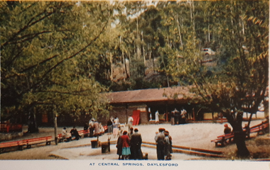
... ...loddon springs...Images include: Panorama over Daylesford, from lookout tower Panorama over Lake Daylesford Pioneer Memorial Lookout Tower, Daylesford Near the swimming pool, Lake Daylesford Botanical Gardens, Daylesford Vincent Street, showing Town Hall, Daylesford Vincent Street, Daylesford Glimpse of lovely Jubilee Lake, Daylesford Central Springs, Daylesford Sutton Springs, Daylesford Corner of the beautiful Botanical Gardens, Daylesford Loddon Falls, near Daylesford....Ballarat Heritage Services PO Box 2209 Bakery Hill Post Office goldfields Daylesford in a tourist town with natural mineral water springs daylesford jubillee lake wombat hill vincent street sutton springs central springs loddon springs pioneer lookout pioneer memorial lookout loddon falls lake daylesford A booklet of colour images depicting 12 scenes of Daylesford, Victoria. ...Daylesford in a tourist town with natural mineral water springsA booklet of colour images depicting 12 scenes of Daylesford, Victoria. The front cover is decorated with an illustration of a dirt road with sign post. Images include: Panorama over Daylesford, from lookout tower Panorama over Lake Daylesford Pioneer Memorial Lookout Tower, Daylesford Near the swimming pool, Lake Daylesford Botanical Gardens, Daylesford Vincent Street, showing Town Hall, Daylesford Vincent Street, Daylesford Glimpse of lovely Jubilee Lake, Daylesford Central Springs, Daylesford Sutton Springs, Daylesford Corner of the beautiful Botanical Gardens, Daylesford Loddon Falls, near Daylesford.daylesford, jubillee lake, wombat hill, vincent street, sutton springs, central springs, loddon springs, pioneer lookout, pioneer memorial lookout, loddon falls, lake daylesford -
 Federation University Historical Collection
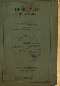
Book, Mines Department, Victoria, Deep Leads of Victoria, 1937, 1937
... loddon system...clunes...creswick...spring...Contents include Ballarat, berry Consols, Canadian Lead, Castlemaine-Daylesford System, Chiltern, Duke of Cornwall Mine, Dyke's Freehold, Frenchman's Lead, Garibaldi Shaft, Glenfine, Guidlford, Hepburn Estate Co., Hepburn Home Paddock, Italian Gully, Henderson's Lead, Langi Logan, Leigh Consols, Sebastopol Plateau; Talbot, Woady Yalloak, A definition of a deep lead, formation of deep leads, water in deep leads, methods of deep lead mining (Tunnelling, Deep sinking, Chiltern method of working, Ballarat method of working), sampling washdirt and gravels, Balmoral, Mt William, Stawell, Moyston, Great Western, Ararat, Raglan, Wimmera Valley, Landsborough, Cardigan, Haddon, Beaufort, Waterloo, Avoca, Lamplough, Caralulup, Ballarat West, Ballarat, Smythesdale, Glenfine, Illabarook, Durham Lead, Morrison's Lead, Bullengarook, Berry-Moolort-Loddon System, Clunes, Creswick, Spring Hill, Bullarook, Castlemaine - Daylesford, Majorca, Carisbrook, Timor, Burnt Creek Tributary, Tarnagulla, Marong, Rheola, Inglewood, Huntly, Coliban, Campaspe, Goulburn Lead System, Ovens Valley System, Mitta Mitts, Kiewa Valley, Tarago, Tanjil, Moondarra, Bogong, Dargo High Plains, glossary...Barker Library (top floor) Mount Helen goldfields mining deep leads mines department squire leigh consols chiltern duke of cornwall mine dyke's freehold frenchman's lead garibaldi shaft glenfine guidlford hepburn estate co. hepburn home paddock italian gully henderson's lead langi logan sebastopol plateau talbot woady yalloak tunnelling deep sinking chiltern method of working ballarat method of working sampling washdirt. gravels balmoral mt william stawell moyston great western ararat raglan wimmera valley landsborough cardigan haddon beaufort waterloo avoca lamplough caralulup ballarat west ballarat smythesdale illabarook durham lead morrison's lead bullengarook berry-moolort-loddon system clunes creswick spring hill bullarook castlemaine - daylesford majorca carisbrook timor burnt creek tributary tarnagulla marong rheola inglewood huntly coliban campaspe goulburn lead system ovens valley system mitta mitta kiewa valley tarago tanjil moondarra bogong dargo high plains Charcoal green soft covered book of 64 pages. ...Charcoal green soft covered book of 64 pages. Contents include Ballarat, berry Consols, Canadian Lead, Castlemaine-Daylesford System, Chiltern, Duke of Cornwall Mine, Dyke's Freehold, Frenchman's Lead, Garibaldi Shaft, Glenfine, Guidlford, Hepburn Estate Co., Hepburn Home Paddock, Italian Gully, Henderson's Lead, Langi Logan, Leigh Consols, Sebastopol Plateau; Talbot, Woady Yalloak, A definition of a deep lead, formation of deep leads, water in deep leads, methods of deep lead mining (Tunnelling, Deep sinking, Chiltern method of working, Ballarat method of working), sampling washdirt and gravels, Balmoral, Mt William, Stawell, Moyston, Great Western, Ararat, Raglan, Wimmera Valley, Landsborough, Cardigan, Haddon, Beaufort, Waterloo, Avoca, Lamplough, Caralulup, Ballarat West, Ballarat, Smythesdale, Glenfine, Illabarook, Durham Lead, Morrison's Lead, Bullengarook, Berry-Moolort-Loddon System, Clunes, Creswick, Spring Hill, Bullarook, Castlemaine - Daylesford, Majorca, Carisbrook, Timor, Burnt Creek Tributary, Tarnagulla, Marong, Rheola, Inglewood, Huntly, Coliban, Campaspe, Goulburn Lead System, Ovens Valley System, Mitta Mitts, Kiewa Valley, Tarago, Tanjil, Moondarra, Bogong, Dargo High Plains, glossarymining, deep leads, mines department, squire, leigh consols, chiltern, duke of cornwall mine, dyke's freehold, frenchman's lead, garibaldi shaft, glenfine, guidlford, hepburn estate co., hepburn home paddock, italian gully, henderson's lead, langi logan, sebastopol plateau, talbot, woady yalloak, tunnelling, deep sinking, chiltern method of working, ballarat method of working, sampling washdirt. gravels, balmoral, mt william, stawell, moyston, great western, ararat, raglan, wimmera valley, landsborough, cardigan, haddon, beaufort, waterloo, avoca, lamplough, caralulup, ballarat west, ballarat, smythesdale, illabarook, durham lead, morrison's lead, bullengarook, berry-moolort-loddon system, clunes, creswick, spring hill, bullarook, castlemaine - daylesford, majorca, carisbrook, timor, burnt creek tributary, tarnagulla, marong, rheola, inglewood, huntly, coliban, campaspe, goulburn lead system, ovens valley system, mitta mitta, kiewa valley, tarago, tanjil, moondarra, bogong, dargo high plains -
 Federation University Historical Collection
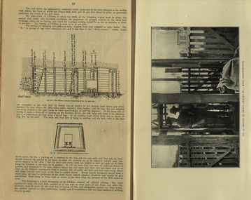
Book, Stanley B. Hunter, Memoirs of the Geological Survey of Victoria No 7., The Deep Leads of Victoria, 1909
... loddon system...clunes...creswick...spring...Contents include tunnelling, deep sinking, the Chiltern Method, the Ballarat Method, Stawell, Ararat, Moyston, Raglan, Wimmera, Landsborough, Avoca, Ballarat West Leads, Berry-Moolort-Loddon Lead System, Clunes, Creswick, Bullarook Affluent, Corinella, Daylesford-Castlemaine Tributary, Majorca-Carisbrook tributary, Huntly, Coliban, Campaspe, Rutherglen., Smythesdale, Durham Lead, Tanjil, Evolution of Mining Machinery, size of claims, Definition of a Deep Lead, Discovery of Gold in Victoria, Geographical Position of Deep Leads, Water in Deep Leads, Methods of Deep Lead Mining, Cost of Deep Lead Mining, Stawell, Ararat, Moyston, Raglan, Wimmera, Landsborough, Avoca, Ballarat West, Berry, Springs Hill, Loddon Valley, Charlotte Plains, , Timor, Burn Creek, Huntly, Colinan, Goulburn, Ovens Valley, Chiltern, Indigo, Morrison's Lead, Plans include: geological Map of Stawell, ararat, Raglan and Landsborough; Kempson's Freehold Mine, Stawell; Geological Map of Beaufort, Avoca, Maryborough, Ballarat west, Berry-Moolort, Loddon, Creswick, Marong, &c; Cardigan Propriety Gold Mine; Working Miners United Gold Mine, Homebush; Hepburn Deep Lead Plan; Madame Berry West Mine; West Berry Consols Mine; Spring Hill and Central Leads; Berry Consols Extended Mine; Loddon Valley Goldfields; Chalk's No 3 Mine; Charlotte Plains Considated Mine; Duke United Mine; Geological Map of Bendigo, Huntley, Campaspe, Malmsbury, Kyneton, trentham, &c; Geological Map of Chiltern, Rutherglan, Eldorado, Beechworth, &c; Chiltern Valley Gold Mine; Wallace Chiltern Valley Consols Mine; great Southern and Chiltern Valley United Mine; great Northern extended Consols; Prentice and Southern deep Leads; Glenfine South Gold Mine; Geological map of Pitfield, Rokewood, Mt Mercer, Ballark, Meredith, &c.; McEvoy Mine; Dargo . . . . . . . . . . . . . . . . . . . . . . . ...Barker Library (top floor) Mount Helen goldfields mining deep leads squire tools gold panning gold cradle cradling puddling tubbing mining shaft shaft sinking whip horse whip whim horse whim chalk's no. 1 mine, maryborough mining cage shaft mining trucks maryborough washdirt puddler tunnelling deep sinking chiltern method of working ballarat method of working sampling washdirt. gravels balmoral mt william stawell moyston great western ararat raglan wimmera valley landsborough cardigan haddon beaufort waterloo avoca lamplough caralulup ballarat west ballarat smythesdale glenfine illabarook durham lead morrison's lead bullengarook berry-moolort-loddon system clunes creswick spring hill bullarook castlemaine - daylesford majorca carisbrook timor burnt creek tributary tarnagulla marong rheola inglewood huntly coliban campaspe goulburn lead system ovens valley system mitta mitta kiewa valley tarago tanjil moondarra bogong dargo high plains Pink paper covered book by Stanley Hunter, Engineer in Charge of Boring Operations. ...Pink paper covered book by Stanley Hunter, Engineer in Charge of Boring Operations. Contents include tunnelling, deep sinking, the Chiltern Method, the Ballarat Method, Stawell, Ararat, Moyston, Raglan, Wimmera, Landsborough, Avoca, Ballarat West Leads, Berry-Moolort-Loddon Lead System, Clunes, Creswick, Bullarook Affluent, Corinella, Daylesford-Castlemaine Tributary, Majorca-Carisbrook tributary, Huntly, Coliban, Campaspe, Rutherglen., Smythesdale, Durham Lead, Tanjil, Evolution of Mining Machinery, size of claims, Definition of a Deep Lead, Discovery of Gold in Victoria, Geographical Position of Deep Leads, Water in Deep Leads, Methods of Deep Lead Mining, Cost of Deep Lead Mining, Stawell, Ararat, Moyston, Raglan, Wimmera, Landsborough, Avoca, Ballarat West, Berry, Springs Hill, Loddon Valley, Charlotte Plains, , Timor, Burn Creek, Huntly, Colinan, Goulburn, Ovens Valley, Chiltern, Indigo, Morrison's Lead, Plans include: geological Map of Stawell, ararat, Raglan and Landsborough; Kempson's Freehold Mine, Stawell; Geological Map of Beaufort, Avoca, Maryborough, Ballarat west, Berry-Moolort, Loddon, Creswick, Marong, &c; Cardigan Propriety Gold Mine; Working Miners United Gold Mine, Homebush; Hepburn Deep Lead Plan; Madame Berry West Mine; West Berry Consols Mine; Spring Hill and Central Leads; Berry Consols Extended Mine; Loddon Valley Goldfields; Chalk's No 3 Mine; Charlotte Plains Considated Mine; Duke United Mine; Geological Map of Bendigo, Huntley, Campaspe, Malmsbury, Kyneton, trentham, &c; Geological Map of Chiltern, Rutherglan, Eldorado, Beechworth, &c; Chiltern Valley Gold Mine; Wallace Chiltern Valley Consols Mine; great Southern and Chiltern Valley United Mine; great Northern extended Consols; Prentice and Southern deep Leads; Glenfine South Gold Mine; Geological map of Pitfield, Rokewood, Mt Mercer, Ballark, Meredith, &c.; McEvoy Mine; Dargo . . . . . . . . . . . . . . . . . . . . . . . mining, deep leads, squire, tools, gold panning, gold cradle, cradling, puddling, tubbing, mining shaft, shaft sinking, whip, horse whip, whim, horse whim, chalk's no. 1 mine, maryborough, mining cage, shaft, mining trucks, maryborough, washdirt, puddler, tunnelling, deep sinking, chiltern method of working, ballarat method of working, sampling washdirt. gravels, balmoral, mt william, stawell, moyston, great western, ararat, raglan, wimmera valley, landsborough, cardigan, haddon, beaufort, waterloo, avoca, lamplough, caralulup, ballarat west, ballarat, smythesdale, glenfine, illabarook, durham lead, morrison's lead, bullengarook, berry-moolort-loddon system, clunes, creswick, spring hill, bullarook, castlemaine - daylesford, majorca, carisbrook, timor, burnt creek tributary, tarnagulla, marong, rheola, inglewood, huntly, coliban, campaspe, goulburn lead system, ovens valley system, mitta mitta, kiewa valley, tarago, tanjil, moondarra, bogong, dargo high plains -
 Bendigo Historical Society Inc.
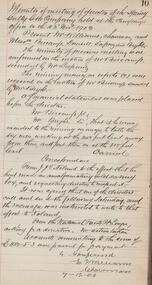
Administrative record - Spring Gully Gold Mining Co. Fryerstown, Minute Book1903 - 1915, 1924 - 1929
... Loddon River. 'the benefit that the mines in your district derive from the bridge being open for wood waggons and this being the main traffic and this being the principal cause of the bridges present condition'. 4. Prospectus of the Spring...Loddon River. 'the benefit that the mines in your district derive from the bridge being open for wood waggons and this being the main traffic and this being the principal cause of the bridges present condition'. 4. Prospectus of the Spring ...The Spring Gully Gold Mining property consists of Gold Mining Lease No. 2986, Castlemaine, of about 21 acres situated on the Emu Reef, in Spring Gully Fryers. There are two shafts, distant about 300 feet from each other. From one of them large quantities of gold were obtained in former years by previous companies. ( Prospectus of the Spring Gully Mining CompanyMaroon hard cover book, brown leather binding on spine and corners, three hundred and eighty pages. Written on spine of book in gold leaf : 'Minute Book'. Handwritten minute entries from 14th September 1903 to 30th August 1915. Affixed to first page, newspaper clipping from the 'Herald' 13/9/05, with information about the Spring Gully Mine Fryerstown. Page eighty-one has two quotes affixed from 'The Yarraville Chlorination and Ore Reduction Works' High Street Yarraville, July 1905, for works associated with pyrites and blanket sand. Page nine, a handwritten letter affixed to minutes, applying for a block of land 250 feet north of main shaft. Signed by J.S. Potter, H. Hancock, G Murray and T. Tumney. 1.Page one hundred and one: three quotes from 'Edwards' Metallurgical Works' Specimen Hill, Bendigo for pyrites and blanket sand. 2.Page one hundred and fifty five: handwritten letter (copy) from A. Schonfelder re shaft work on the mine and mention of tributors 3. Affixed to inside cover: letter from the 'United Shire of Mount Alexander' April 15th. 1907, regarding the reconstruction of the Vaughan bridge over the Loddon River. 'the benefit that the mines in your district derive from the bridge being open for wood waggons and this being the main traffic and this being the principal cause of the bridges present condition'. 4. Prospectus of the Spring Gully Mining Company, Spring Gull, Fryerstown, two page folded document enclosed inside back cover of book. Prospectus incomplete. (10746.93a) 5. Carbon copy of letter to D.E. Williams Esq, Castlemaine from GlenAthol, Casewick Road, London, January 25th, 1907 regarding two gentlemen who were 'called upon to carry the 'Spring Gullys' through - Mr. H. 'is making a determined effort to bring the matter to a successful issue' Letter signed by George Allan. (10746.93b. 6. Carbon copy of letter from E. Williams, London re proposed new company to acquire the properties of Spring G.M. Coy, Spring Gully G.M. Coy. No. 1, Sth Spring Gully G.M. Coy, Sth Spring Gully G.M. Coy Extended (10746.93c) 7. Handwritten letter to the Chairman and Directors of the Spring Gully G.M. Co. re the appointment of 'Mr. Samuel Morse Battery Manager at once, or accept my resignation as Mining Manager, for we can't agree any longer' Signed by A. Schonfelder. 8. Notice of extraordinary meeting of shareholders in Spring Gully Gold Mining Company No Liability, 22nd November 1906 at Beehive Chambers, Bendigo. Signed W.G. Blackham (Blackham & Garvin) Manager of the Company. (10746.93e) The Minute Book is part of the Margaret Roberts Collection of mining documents.bendigo, margaret roberts, , goldmining, castlemaine, spring gully gold mine, fryertown -
 Ballarat Heritage Services
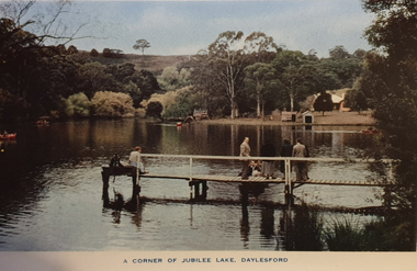
Souvenir - Image from a Postcard Booklet Image, Jubilee Lake, Daylesford, c1945
... Botanical Gardens, Daylesford Vincent Street, showing Town Hall, Daylesford Vincent Street, Daylesford Glimpse of lovely Jubilee Lake, Daylesford Central Springs, Daylesford Sutton Springs, Daylesford Corner of the beautiful Botanical Gardens, Daylesford Loddon Falls, near Daylesford....Ballarat Heritage Services PO Box 2209 Bakery Hill Post Office goldfields Daylesford in a tourist town with natural mineral water springs daylesford jubillee lake Botanical Gardens, Daylesford Vincent Street, showing Town Hall, Daylesford Vincent Street, Daylesford Glimpse of lovely Jubilee Lake, Daylesford Central Springs, Daylesford Sutton Springs, Daylesford Corner of the beautiful Botanical Gardens, Daylesford Loddon Falls, near Daylesford. ...Daylesford in a tourist town with natural mineral water springs Botanical Gardens, Daylesford Vincent Street, showing Town Hall, Daylesford Vincent Street, Daylesford Glimpse of lovely Jubilee Lake, Daylesford Central Springs, Daylesford Sutton Springs, Daylesford Corner of the beautiful Botanical Gardens, Daylesford Loddon Falls, near Daylesford.daylesford, jubillee lake -
 Ballarat Heritage Services
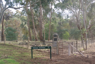
Photograph - Colour, Vaughan Chinese Cemetery, 2017, 16/07/2017
... Loddon River). The location of the cemetery was chosen because it was a convenient piece of ground where gold was not likely to be discovered, and burials were mainly of Chinese miners. It remained in use until 1857. The cemetery was restored in 1929 using money raised within the Chinese communities of Bendigo and Castlemaine. vaughan vaughan springs ...Established during the great Mount Alexander alluvial gold rush of 1852-54 the cemetery is located on a small hill overlooking one of the richest spots on the goldfield (the junction of Fryers Creek and Loddon River). The location of the cemetery was chosen because it was a convenient piece of ground where gold was not likely to be discovered, and burials were mainly of Chinese miners. It remained in use until 1857. The cemetery was restored in 1929 using money raised within the Chinese communities of Bendigo and Castlemaine. Colour photograph of the Chinese Cemetery at Vaughan. vaughan, vaughan springs, vaughan chinese cemetery, chinese