Showing 86 items matching "longitudinal section"
-
 Bendigo Historical Society Inc.
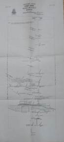
Map - COMET MINE - LONGITUDINAL SECTION COMET MINE
... COMET MINE - LONGITUDINAL SECTION COMET MINE...... Longitudinal Section of Comet Mine Bulletin No 33 Plate No XXVI...Longitudinal section of the Comet Mine on the Hustler's Line of Reef Bulletin No 33, Plate No XXVI signed by H. ...Map COMET MINE - LONGITUDINAL SECTION COMET MINE ...Longitudinal section of the Comet Mine on the Hustler's Line of Reef Bulletin No 33, Plate No XXVI signed by H. S. Whitelaw, Underground Survey Office Bendigo, September 1913. Map shows datum lines, depths of levels, approximate boundaries and references to other plans. Note - Plates 4, 8, 13, 20, 26 and 31 form a Longitudinal Section from Fortuna Hustler's to Hustler's Consols Mine. Geological Survey of Victoriamining, parish map, hustler's line of reef, longitudinal section of comet mine bulletin no 33 plate no xxvi, h s whitelaw -
 Bendigo Historical Society Inc.
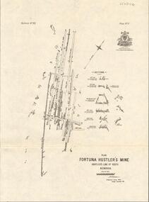
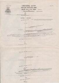
Map - FORTUNA HUSTLER'S MINE - LONGITUDINAL SECTION OF THE FORTUNA HUSTLER'S MINE
... FORTUNA HUSTLER'S MINE - LONGITUDINAL SECTION OF THE FORTUNA HUSTLER'S MINE...... Longitudinal Section of the Fortuna Hustler's Mine...Longitudinal Section of the Fortuna Hustler's Mine on the Hustler's Line of Reef, Bendigo. ...Map FORTUNA HUSTLER'S MINE - LONGITUDINAL SECTION OF THE FORTUNA HUSTLER'S MINE ...Longitudinal Section of the Fortuna Hustler's Mine on the Hustler's Line of Reef, Bendigo. Bulletin No 33, Plate No IV. Shows poppet legs at the surface level, Datum Line 750 feet above Sea Level, levels and their depths, the amount of gold per ton and some geographical features. Geological Survey of Victoria emblem and signed by H A Whitelaw, Underground Survey Office, Bendigo. Note - Plates 4, 8, 13, 20, 26 & 31 form a Longitudinal Section from Fortuna Hustler's to Hustler's Consols Mine. mining, parish map, fortuna hustler's mine, longitudinal section of the fortuna hustler's mine, geological survey of victoria, h a whitelaw, underground survey office bendigo, hustler's line of reef, hustler's consols mine -
 Federation University Historical Collection
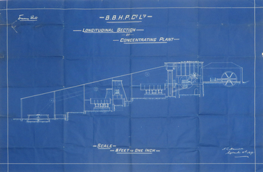
Plan, Blueprint B.B.H.P. Co Ltd Longitudinal Section of Concentrating Plant, 1895
... Blueprint B.B.H.P. Co Ltd Longitudinal Section of Concentrating Plant......longitudinal section...blueprint h. l. hancock longitudinal section concentrating plant BHP Blueprint plan by H.L. ...Blueprint plan by H.L. Hancock blueprint, h. l. hancock, longitudinal section, concentrating plant, bhp -
 Federation University Historical Collection
Plan, Ballarat East Longitudinal Section, not dated
... Ballarat East Longitudinal Section ......longitudinal section...plan ballarat east longitudinal section mining Printed plan of Ballarat East showing pitch of quartz veins and crosscourses Sheet No 2 Ballarat East Longitudinal Section Plan Plan ...Printed plan of Ballarat East showing pitch of quartz veins and crosscourses Sheet No 2plan, ballarat east, longitudinal section, mining -
 Federation University Historical Collection
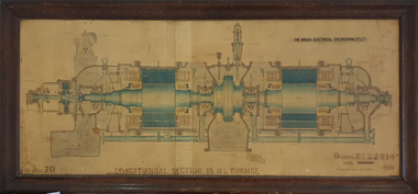
Drawing, Longitudinal Section 15 B.L. Turbine, 1921
... Longitudinal Section 15 B.L. Turbine...Framed drawing of a longitudinal section of a 15 B.L. Turbine. It was drawn by R.O.S. and C.B. on 31 July 1919 and traced by N. ...Brown on 07 October 1921. Longitudinal Section 15 B.L. Turbine Drawing N. Brown ...This work most probably hung in a laboratory at the Ballarat School of Mines.Framed drawing of a longitudinal section of a 15 B.L. Turbine. It was drawn by R.O.S. and C.B. on 31 July 1919 and traced by N. Brown on 07 October 1921.turbine, n. brown, ballarat school of mines -
 Bendigo Historical Society Inc.
Map - HUSTLER'S REEF & HUSTLER'S REEF NO 1 MINES - LONGITUDINAL SECTION OF THE HUSTLER'S REEF & HUSTLER'S
... HUSTLER'S REEF & HUSTLER'S REEF NO 1 MINES - LONGITUDINAL SECTION OF THE HUSTLER'S REEF & HUSTLER'S...Longitudinal Section of the Hustler's Reef & Hustler's Reef No 1 Mines on the Hustler's Line of Reef. ...Note - Plates 4, 8, 13, 20, 26 & 31 form a Longitudinal Section from Fortuna Hustler's to Hustler's Consols Mine. ...Longitudinal Section of the Hustler's Reef & Hustler's Reef No 1 Mines on the Hustler's Line of Reef. Bulletin No 33, Plate No XX. Note - Plates 4, 8, 13, 20, 26 & 31 form a Longitudinal Section from Fortuna Hustler's to Hustler's Consols Mine. Geological Survey of Victoria emblem. Signed by H A Whitelaw, Underground Survey Office Bendigo, September 1913. Shows the two shafts with their levels and depths. Also shows geographical features and yields of gold and amalgam per ton. .mining, parish map, hustler's reef & hustler's reef no 1 mines, geographical survey of victoria, underground survey office bendigo, h a whitelaw -
 Bendigo Historical Society Inc.
Map - GREAT EXTENDED HUSTLER'S MINE - LONGITUDINAL SECTION OF THE GREAT EXTENDED HUSTLER'S MINE
... GREAT EXTENDED HUSTLER'S MINE - LONGITUDINAL SECTION OF THE GREAT EXTENDED HUSTLER'S MINE...Longitudinal Section of the Great Extended Hustler's Mine on the Hustler's Line of Reefs. ...Map GREAT EXTENDED HUSTLER'S MINE - LONGITUDINAL SECTION OF THE GREAT EXTENDED HUSTLER'S MINE ...Longitudinal Section of the Great Extended Hustler's Mine on the Hustler's Line of Reefs. Bulletin No 33, Plate No XIII. Map shows the Hustler's Tribute, 2 Old Shafts, Great Extended Hustler's Shaft, Latham & Watson's Shaft and Ironbark Gully. Datum Line 750 feet above Sea Level. Poppet Legs on the surface and Sill of Shaft 788.99 feet above Sea Level. Levels and their depths are shown and some geographical features. Some amounts of gold mined mentioned. Geological Survey of Victoria emblem and signed by H A Whitelaw, Underground Survey Office Bendigo, September 1913. Note - Plates 4, 8, 13,20, 26 & 31 form a Longitudinal Section from Fortuna Hustlers to Hustler's Consols Mine. mining, parish map, great extended hustler's mine, geological survey of victoria, underground survey office bendigo, h a whitelaw, hustler's tribute, old shaft, great extended hustler's shaft, latham & watson's shaft, ironbark gully -
 Bendigo Historical Society Inc.
Map - HUSTLER'S ROYAL RESERVE NO 2 CO. - LONGITUDINAL SECTION OF THE HUSTLER'S ROYAL RESERVE NO 2 CO
... HUSTLER'S ROYAL RESERVE NO 2 CO. - LONGITUDINAL SECTION OF THE HUSTLER'S ROYAL RESERVE NO 2 CO....Longitudinal Section of the Hustler's Royal Reserve No 2 Co. on the Hustler's Line of Reef Bulletin No 33, Plate No VIII. ...Note - Plates 4, 8, 13, 20, 26 & 31 form a Longitudinal Section from Fortuna Hustler's to Hustler's Consols Mine. ...Longitudinal Section of the Hustler's Royal Reserve No 2 Co. on the Hustler's Line of Reef Bulletin No 33, Plate No VIII. Note - Plates 4, 8, 13, 20, 26 & 31 form a Longitudinal Section from Fortuna Hustler's to Hustler's Consols Mine. Mines mentioned are the Hustler's Royal Reserve No 2 Main Shaft, Hustler's Royal Reserve No 2 Park Shaft, Royal Hustler's, Imperial Hustler's, Great Extended Hustler's Freehold and the Great Extended. Section shows depth of levels, datum lines and height of sill above sea level yield in oz. of gold. Geological Survey of Victoria emblem. H. Herman, Director, W. Dickson, Secretary for Mines and The Hon. J. Drysdale Brown MLC, Minister for Mines and signed by H S Whitelaw, Underground Survey Office Bendigo, September 1913. mining, parish map, hustler's royal reserve no 2, royal hustler's, imperial hustler's, great extended hustler's freehold, great extended, geological survey of victoria, underground survey office bendigo, h s whitelaw, h herman, w dickson, the hon j drysdale brown -
 Bacchus Marsh & District Historical Society
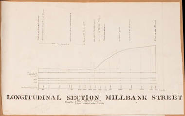
Drawing, Longitudinal Section Millbank Street Bacchus Marsh circa 1905
... Longitudinal Section Millbank Street Bacchus Marsh circa 1905...Single page plan showing a longitudinal section view of MIllbank Street running from Clarinda Street to Grant Street in Bacchus Marsh. ...High resolution digital image stored on BMDHS computer network. Longitudinal Section Millbank Street Bacchus Marsh circa 1905 Drawing Shire of Bacchus Marsh ...Millbank Street is a short street located close to the central business and shopping area of Bacchus Marsh. In the early 1900s works to improve the drainage of the street were discussed and planned by Bacchus Marsh Shire Council. This plan is most probably the plan discussed at a Shire Council meeting in April 1905. Single page plan showing a longitudinal section view of MIllbank Street running from Clarinda Street to Grant Street in Bacchus Marsh. The names of Millbank Street property owners, Cain, Shelley, Oliver and Ramsay are marked on this plan. Scale: Vertical 10 feet to 1 inch. Horizontal: 100 links to 1 inch Part of a set of maps which are pasted into a bound volume containing 76 maps or plans in total. High resolution digital image stored on BMDHS computer network. bacchus marsh victoria maps, millbank street bacchus marsh -
 Bendigo Historical Society Inc.
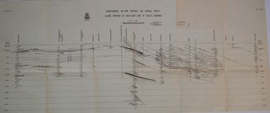
Map - HUSTLERS LINE OF REEFS - LONGITUDINAL SECTION THROUGH THE SADDLE REEFS
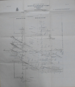
... HUSTLERS LINE OF REEFS - LONGITUDINAL SECTION THROUGH THE SADDLE REEFS...Drawing with Longitudinal Section through the Saddle Reefs along portion of Hustler's Line of Reefs, Bendigo. ...Map HUSTLERS LINE OF REEFS - LONGITUDINAL SECTION THROUGH THE SADDLE REEFS ...Drawing with Longitudinal Section through the Saddle Reefs along portion of Hustler's Line of Reefs, Bendigo. Map shows the depth of the mines, reef numbers and Datum 700 ft above sea level. North and South is also noted on the map. Map signed by H. S, Whitelaw, Underground Survey Office, Bendigo, September 1913. Bulletin No 33, Plate No XXXIV. Bendigo Creek, Ironbark Creek and Long Gully are also noted. Mines are: Fortuna Hustlers, Hustler's Royal Reserve No 2 Main Shaft, Hustler's Royal Reserve No 2 Park Shaft, Royal Hustler's, Imperial Hustler's, Extended Hustler's Freehold, Great Extended Hustler's Tribute (Pups), Old Shaft, Great Extended Hustler's Reef No 2, Great Extended Hustler's Main Shaft, Old Shaft, Hustler's Reef, Hustler's Reef No 1, Comet, K. K., United Hustler's & Redan, Old Shaft and Hustler's Consols. Has Geological Survey of Victoria Crest and underneath is: H. Herman, Director, W. Dickson, Secretary for Mines, The Hon. J Drysdale Brown M L C. Minister of Mines.Geological Survey of Victoria Crestmining, hustler's reef maps, hustlers line of reefs, bendigo creek, royal hustler's, imperial hustler's, extended hustler's freehold, great extended hustler's tribute (pups), great extended hustler's reef no 2, great extended hustler's main shaft, hustler's reef, hustler's reef no 1, united hustler's & redan, old shaft and hustler's consols.h s whitelaw, underground survey office bendigo september 1913 -
 Bendigo Historical Society Inc.
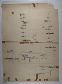
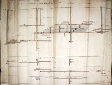
Document - MINING PLAN longitudinal section, Circa 1880's
... MINING PLAN longitudinal section...Adventure and Advance Mining plan: Showing shafts and layout of Gibbs, Ballerstedt and wells, Humboldt Co., Great Central Victoria Co., Adventure and Advance (in two pieces) Document MINING PLAN longitudinal section ...Mining plan: Showing shafts and layout of Gibbs, Ballerstedt and wells, Humboldt Co., Great Central Victoria Co., Adventure and Advance (in two pieces)topic, mining, plans, gold mines bendigo, gibbs, ballerstedt, wells, humboldt co., great central victoria co., adventure and advance -
 Bendigo Historical Society Inc.
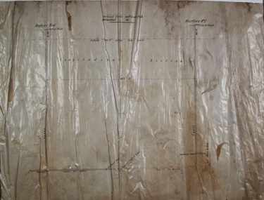
Plan - Hustlers Reef
... ...longitudinal section...Drawn on waxed paper, longitudinal section showing Hustlers Reef and Hustlers Reef No. 1 shafts. ...Margaret Roberts gold gold mine Hustlers Reef Hustlers Hill Great Extended Hustlers Hustlers No. 1 longitudinal section Drawn on waxed paper, longitudinal section showing Hustlers Reef and Hustlers Reef No. 1 shafts. ...Drawn on waxed paper, longitudinal section showing Hustlers Reef and Hustlers Reef No. 1 shafts. Written on plan: 'Vertical scale 100 ft to an inch. Horizontal scale 40 ft to an inch.' Plan forms part of the Margaret Roberts Collection of mining records. margaret roberts, gold, gold mine, hustlers reef, hustlers hill, great extended hustlers, hustlers no. 1, longitudinal section -
 Bendigo Historical Society Inc.
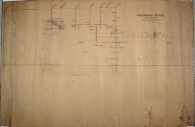
Plan - Old Napoleon Gold Mine, 9.11.45
... ...longitudinal section...Written across top of plan: Longitudinal Section. Scale 100 ft to 1 inch. Compiled from Mine Manager's notes, J. ...Old Napoleon Gold Mine: Bendigo Independent 24th October, 1910: '......resumption of work at the Old Napoleon Company's shaft at Sydney Flat will shortly be undertaken by a new company' Bendigo Margaret Roberts gold Old Napoleon shaft Sydney Flat longitudinal section Old Napoleon Gold Mine. Written across top of plan: Longitudinal Section. ...Old Napoleon Gold Mine: Bendigo Independent 24th October, 1910: '......resumption of work at the Old Napoleon Company's shaft at Sydney Flat will shortly be undertaken by a new company'Old Napoleon Gold Mine. Written across top of plan: Longitudinal Section. Scale 100 ft to 1 inch. Compiled from Mine Manager's notes, J. J. Caldwell, 9.11.45. Plan forms part of the Margaret Roberts Collection of mining records. bendigo, margaret roberts, gold, old napoleon, shaft, sydney flat, longitudinal section -
 Melbourne Tram Museum
Drawing - Digtial image, Melbourne & Metropolitan Tramways Board (MMTB), "Plan and Longitudinal sections of Howard Street Siding", 2/1925
... Shows the plan and longitudinal sections. Prepared 23/2/1925 and signed by Mr Strickland Chief Engineer on 25/2/1925. ...Digital image of drawing P1613, "Plan and Longitudinal sections of Howard Street Siding"....Shows the plan and longitudinal sections. Prepared 23/2/1925 and signed by Mr Strickland Chief Engineer on 25/2/1925. ...Digital image of a drawing for the access tracks to the Howard St car house or cable tram depot from Victoria St. Shows the plan and longitudinal sections. Prepared 23/2/1925 and signed by Mr Strickland Chief Engineer on 25/2/1925. This depot was made necessary by the construction of electric tram tracks in Flemington Road in 1925 which resulted in the closure of the Flemington Road car house near Racecourse Road North Melbourne.Yields information about the access track from Victoria St to the Howard St car house. Digital image of drawing P1613, "Plan and Longitudinal sections of Howard Street Siding".m&mtb, drawings, howard st, cable trams, car houses, depots -
Port Melbourne Historical & Preservation Society
Plan - Cross sectional drawing, recommendations by Sir John Coode, Thomas Kell Lith, 1880
... Large cross sectional drawing of longitudinal and cross section of works as recommended by Sir John Coode in his 1879 report...Melbourne Harbour Trust Longitudinal and Cross section of works...Port Melbourne Historical & Preservation Society Port Melbourne Town Hall 333 Bay Street Port Melbourne melbourne built environment engineering - canals and drainage melbourne harbor trust - port of melbourne authority sir john coode coode canal hobsons bay Melbourne Harbour Trust Longitudinal and Cross section of works Large cross sectional drawing of longitudinal and cross section of works as recommended by Sir John Coode in his 1879 report Plan Cross sectional drawing, recommendations by Sir John Coode Thomas Kell Lith ...Large cross sectional drawing of longitudinal and cross section of works as recommended by Sir John Coode in his 1879 reportMelbourne Harbour Trust Longitudinal and Cross section of worksbuilt environment, engineering - canals and drainage, melbourne harbor trust - port of melbourne authority, sir john coode, coode canal, hobsons bay -
 Federation University Historical Collection
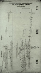
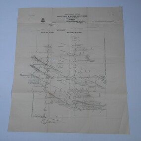
Plan, Underground Survey of Mines, Ballarat East. The Victoria United Company, 1903
... ...longitudinal section...Barker Library (top floor) Mount Helen goldfields ballarat east, victoria united company cgt mining geological survey longitudinal section Underground Survey of The Victoria United Company from Geological Survey of Victoria, Memoirs No. 4. ...Underground Survey of The Victoria United Company from Geological Survey of Victoria, Memoirs No. 4.ballarat east, victoria united company, cgt, mining, geological survey, longitudinal section -
 Bendigo Historical Society Inc.
Plan - United Ulster Company, 9.11.45
... ...longitudinal section...Bendigo Margaret Roberts gold shaft longitudinal section Ulster United Co. Quarry Hill Plan of lease holding drawn on off white paper, black ink. ...The Ulster United Gold Mine was located off Honeybone Street, Quarry Hill.Plan of lease holding drawn on off white paper, black ink. Written on top of plan: United Ulster Co.; on bottom right: W.H. Cundy Bendigo 29th January 1902. Hand drawn on bottom left of plan 'reef near north end. 10 ft to 1 inch'. Plan forms part of the Margaret Roberts Collection of mining records. bendigo, margaret roberts, gold, shaft, longitudinal section, ulster united co., quarry hill -
 Bendigo Historical Society Inc.
Plan - New Prince of Wales Mine
... ...longitudinal section...Bendigo Margaret Roberts gold shaft longitudinal section New Prince of Wales Eaglehawk New Prince of Wales transverse section showing levels and shafts. ...New Prince of Wales transverse section showing levels and shafts. Written on top of plan: 'New Prince of Wales workings shewing (railway. No 11, No. 1 and Old Prince of Wales workings' Mine location, nearest intersection, Williams Road and Hopkins Avenue, Eaglehawk. Plan forms part of the Margaret Roberts Collection of mining records. bendigo, margaret roberts, gold, shaft, longitudinal section, new prince of wales, eaglehawk -
Port Melbourne Historical & Preservation Society
Plan - Raglan Street, Port Melbourne, Borough of Sandridge, 1890s
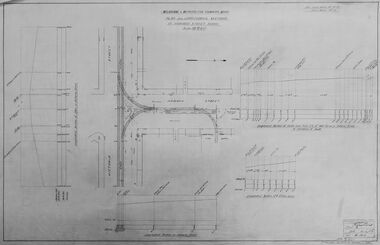
... Plan of Raglan Street showing longitudinal section....Plan of Raglan Street showing longitudinal section. Plan Raglan Street, Port Melbourne Borough of Sandridge ...Plan of Raglan Street showing longitudinal section.Chas Clay (Borough Surveyor):E. Clark (Town Clerk):John Clang (Contractor ?)raglan street, engineering - roads streets lanes and footpaths, town clerks, charles clay, edward clark -
 Federation University Historical Collection
Plan, Madame Bent Gold Mining Company, not dated
... A large plane showing a longitudinal section of the mine....madame bent gold mining company mining A large plane showing a longitudinal section of the mine. Madame Bent Gold Mining Company Plan Plan ...A large plane showing a longitudinal section of the mine.madame bent gold mining company, mining -
Port Melbourne Historical & Preservation Society
Plan - Lyons Street, Port Melbourne, Borough of Sandridge, 9 Oct 1877
... Plan of Lyons Street, showing longitudinal section, ground plan and transverse section....Port Melbourne Historical & Preservation Society Port Melbourne Town Hall 333 Bay Street Port Melbourne melbourne Engineering - Roads Streets Lanes and Footpaths Michael MINAHAN Edward CLARK Town Clerks Minehan, Michael:Clark, Edward C (Town Clerk) Plan of Lyons Street, showing longitudinal section, ground plan and transverse section. ...Plan of Lyons Street, showing longitudinal section, ground plan and transverse section.Minehan, Michael:Clark, Edward C (Town Clerk)engineering - roads streets lanes and footpaths, michael minahan, edward clark, town clerks -
 Bendigo Historical Society Inc.
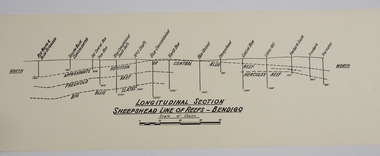
Map - SHEEPSHEAD LINE OF REEF, Circa 1940's
... Map: Plan showing a Longitudinal section of the Sheepshead line of Reefs , Bendigo. (34 Copies)...History House 11 Mackenzie Street Bendigo goldfields MAP Bendigo mining plan Sheepshead line of Reef Gold mines Mining Map: Plan showing a Longitudinal section of the Sheepshead line of Reefs , Bendigo. (34 Copies) Map SHEEPSHEAD LINE OF REEF ...Map: Plan showing a Longitudinal section of the Sheepshead line of Reefs , Bendigo. (34 Copies)map, bendigo, mining plan, sheepshead line of reef, gold mines , mining -
 Bendigo Historical Society Inc.
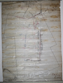
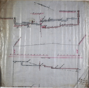
Plan - Goldfields Consolidated Co
... Plan and longitudinal section of Goldfields North and Goldfields Consolidated Co, hand drawn on waxed paper. ...Written on plan: 'Longitudinal Section' and 'W.H. Cundy, July 14th, 1908'. ...Goldfields North and Goldfields Consolidated Co. were located near Diamond Hill, Spring Gully.Plan and longitudinal section of Goldfields North and Goldfields Consolidated Co, hand drawn on waxed paper. Written on plan: 'Longitudinal Section' and 'W.H. Cundy, July 14th, 1908'. Plan forms part of the Margaret Roberts Collection of mining records. margaret roberts, gold, gold mine, goldfields consolidated co., bendigo -
 Bendigo Historical Society Inc.
Map - Hustler's Line of Reef
... Longitudinal section of Hustler's Reef & Hustler's Reef no. 1 mine. ...Hustler's Reef Bendigo Goldfields Hustler's Reef No.1 Mine Longitudinal section of Hustler's Reef & Hustler's Reef no. 1 mine. ...Longitudinal section of Hustler's Reef & Hustler's Reef no. 1 mine. Plate XX, note plates 4,8,13,20, 26 & 31 form a longitudinal section from Fortuna Hustler's to Hustler's Consols Mine. produced by the underground survey office, Bendigo, September 1913.hustler's reef, bendigo goldfields, hustler's reef no.1 mine -
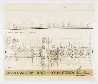 RMIT Design Archives
Architectural drawings, Urban Landscape Design - North Fitzroy
... Features the longitudinal section at Rowe St....Features the longitudinal section at Rowe St. Urban Landscape Design - North Fitzroy Architectural drawings Edmond, Robin Edmond, Robin ...Detailled Area plan of the Urban Renewal Project in North Fitzroy. Features the longitudinal section at Rowe St.ink, acetate -
 Bendigo Historical Society Inc.
Map - STRUGNELL COLLECTION: HUSTLER'S LINE OF REEF, BENDIGO
... Map, Hustler's Line of Reef, Bendigo, Fortuna Hustler's Mine, Longitudinal Section. Plate No. 1V (4). NOTE--- Plates 4,8,13,29,26 & 31 form a Longitudinal Section from Fortuna Hustler's to Hustler's Consols Mine.Bulletin No 33 Signed H.A.Whitelaw. ...Map, Hustler's Line of Reef, Bendigo, Fortuna Hustler's Mine, Longitudinal Section. Plate No. 1V (4). NOTE--- Plates 4,8,13,29,26 & 31 form a Longitudinal Section from Fortuna Hustler's to Hustler's Consols Mine.Bulletin No 33 Signed H.A.Whitelaw. ...Map, Hustler's Line of Reef, Bendigo, Fortuna Hustler's Mine, Longitudinal Section. Plate No. 1V (4). NOTE--- Plates 4,8,13,29,26 & 31 form a Longitudinal Section from Fortuna Hustler's to Hustler's Consols Mine.Bulletin No 33 Signed H.A.Whitelaw. Drawing shows the vertical shaft descending to over 2228 feetUnderground Survey Office, Bendigo.map, bendigo, fortuna hustler's mine -
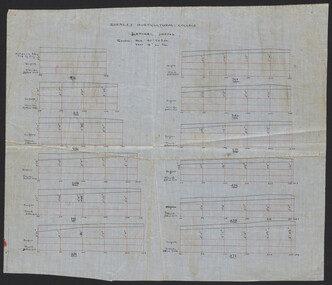 University of Melbourne, Burnley Campus Archives
Plan, Burnley Horticultural College Lateral Drains, c.1930
... Hand drawn on waxed linen. (1) Lateral Drains. (2) Longitudinal Section. From A.W. Jessep file, "Improvements (Completed)."...Jessep Hand drawn on waxed linen. (1) Lateral Drains. (2) Longitudinal Section. From A.W. Jessep file, "Improvements (Completed)." ...Hand drawn on waxed linen. (1) Lateral Drains. (2) Longitudinal Section. From A.W. Jessep file, "Improvements (Completed)."drainage, burnley horticultural school, a.w. jessep -
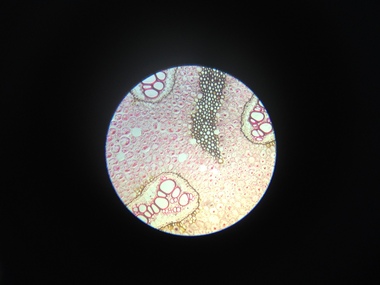 Federation University Historical Collection
Scientific Object, Norman H. Seward, Botanical Microscope Slides, c1950s
... Botanical Microscope Slides in a cardboard box. .1) Zea Mais Annular vessels .2) Protoceus .3) Yeast .4) Eryol .5) Stomata .6) Lichen Physcia Thallus .7) Lichen Cladonia mascilenta .8) Californian Lichen .9) Rhizome Pteris Longitudinal Section .10) Brake fern Pteris Transverse and Longitudinal sections .11) Rhizome Pteris Transverse Section .12) Selaginella sp. - Macro & Micro-sporangia .13) Ovule Pinus Longitudinal section .14) Rachis Pteris Transverse Section .15) Stem Pine Transverse Section ...microscope botanical microscope slides Botanical Microscope Slides in a cardboard box. .1) Zea Mais Annular vessels .2) Protoceus .3) Yeast .4) Eryol .5) Stomata .6) Lichen Physcia Thallus .7) Lichen Cladonia mascilenta .8) Californian Lichen .9) Rhizome Pteris Longitudinal Section .10) Brake fern Pteris Transverse and Longitudinal sections .11) Rhizome Pteris Transverse Section .12) Selaginella sp. - Macro & Micro-sporangia .13) Ovule Pinus Longitudinal section .14) Rachis Pteris Transverse Section .15) Stem Pine Transverse Section Botanical Microscope Slides Scientific Object Norman H. ...Botanical Microscope Slides in a cardboard box. .1) Zea Mais Annular vessels .2) Protoceus .3) Yeast .4) Eryol .5) Stomata .6) Lichen Physcia Thallus .7) Lichen Cladonia mascilenta .8) Californian Lichen .9) Rhizome Pteris Longitudinal Section .10) Brake fern Pteris Transverse and Longitudinal sections .11) Rhizome Pteris Transverse Section .12) Selaginella sp. - Macro & Micro-sporangia .13) Ovule Pinus Longitudinal section .14) Rachis Pteris Transverse Section .15) Stem Pine Transverse Section microscope, botanical microscope slides -
Port Melbourne Historical & Preservation Society
Plan - Pickles Street, Town of Emerald Hill and Borough of Sandridge, Sep 1881
... Town of Emerald Hill and Borough of Sandridge plan for Pickles Street, including transverse and longitudinal sections - Spring to Graham. NB "bridge" near Liardet Street....Port Melbourne Historical & Preservation Society Port Melbourne Town Hall 333 Bay Street Port Melbourne melbourne Engineering - Roads Streets Lanes and Footpaths Charles CLAY Signed by Charles Clay Town of Emerald Hill and Borough of Sandridge plan for Pickles Street, including transverse and longitudinal sections - Spring to Graham. NB "bridge" near Liardet Street. ...Town of Emerald Hill and Borough of Sandridge plan for Pickles Street, including transverse and longitudinal sections - Spring to Graham. NB "bridge" near Liardet Street.Signed by Charles Clayengineering - roads streets lanes and footpaths, charles clay -
Port Melbourne Historical & Preservation Society
Plan - Construction of Liardet Street, Port Melbourne, John Foly?, Draughtsperson, 1860 - 1884
... Working drawing: longitudinal section, ground plan, transverse section for the construction of Liardet Street between Nott Street and Railway Place. ...Port Melbourne Historical & Preservation Society Port Melbourne Town Hall 333 Bay Street Port Melbourne melbourne Engineering - Roads Streets Lanes and Footpaths Engineering Department - Borough of Sandridge Charles CLAY John FOLY Liardet Street "Borough of Sandridge":"Chas Clay":"John Foly" Working drawing: longitudinal section, ground plan, transverse section for the construction of Liardet Street between Nott Street and Railway Place. ...Working drawing: longitudinal section, ground plan, transverse section for the construction of Liardet Street between Nott Street and Railway Place. Between 1860 and 1884."Borough of Sandridge":"Chas Clay":"John Foly"engineering - roads streets lanes and footpaths, engineering department - borough of sandridge, charles clay, john foly, liardet street