Showing 46 items matching lookout point
-
 Marysville & District Historical Society
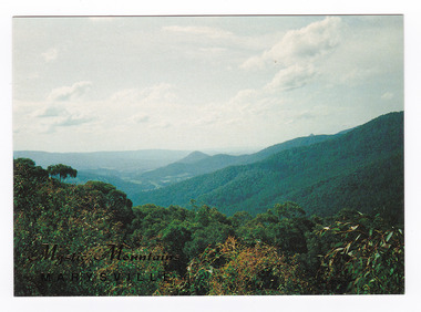
Postcard (item) - Colour postcard, Nucolorvue Productions Pty. Ltd, Mystic Mountains-Marysville, Pre 2009
A colour photograph of the view of the mountains surrounding Marysville in Victoria from Nicholl's Lookout.A colour photograph of the view of the mountains surrounding Marysville in Victoria from Nicholl's Lookout. The mountains surrounding Marysville are known as the Mystic Mountains and Nicoll's Lookout is on the Marysville-Wood's Point Road. The Marysville-Woods Point Road was originally part of the Yarra Track, constructed in the early 1860s to provide access between Healesville and the Woods Point Goldfields. Despite the steep terrain and engineering difficulties, the Yarra Track soon became a busy route used by pack horses, horse-drawn drays, and wagons. Today this sealed mountain road is a popular scenic drive between Marysville and Warburton. This postcard was produced by Nucolorvue Productions in Elwood, Victoria as a souvenir of Marysville.This postcard was produced by Nucolorvue Productions Pty. Ltd. as a souvenir of Marysville.NICHOLS LOOKOUT/ Marysville Victoria NU-COLOR-VUE/ AUSTRALIA'S NATIONAL POSTCARD COMPANY AFFIX/ STAMP/ HERE/ 17MA019/ NCV 9603 POSTCODE COPYRIGHT/ Nucolorvue Productions Pty. Ltd.,/ Telephone: (03) 560-1788/ Made in Australiamarysville, mystic mountains, nicholl's lookout, victoria, nucolorvue productions, postcard, souvenir, marysville-wood's point road, yarra track, healesville, mining, warburton -
 Marysville & District Historical Society
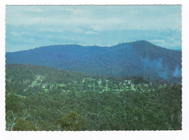
Postcard (item) - Colour postcard, Nucolorvue Productions Pty. Ltd, MARYSVILLE-Victoria, Pre 2009
A colour photograph of the view of Marysville from the Cumberland Range.A colour photograph of the view of Marysville from the Cumberland Range.The Cumberland Valley is notable for its giant mountain ash (Eucalyptus regnans) trees within the Cumberland Memorial Scenic Reserve, and relics from former sawmills and gold mining. The Big Culvert is located nearby on the Marysville-Woods Point Road, which was historically part of the Yarra Track. Cambarville, which is in the Cumberland Valley, was established as a timber mill town in the 1940s. Timber mill owners A Cameron and FJ Barton named Cambarville. They established the mill to salvage timber from trees destroyed in the 1939 bushfires. Cambarville was impacted by the 2009 Black Saturday bushfires and any remaining structures were destroyed. Barton's Lookout was named after a member of the Barton Family who were amongst Marysville's earliest pioneering families. This postcard was produced by Nucolorvue Productions as a souvenir of Marysville.Panorama of Marysville from/ Cumberland Range. NU-COLOR-VUE/ OF/ AUSTRALIA NUCOLORVUE PRODUCTIONS PTY. LTD./ COPYRIGHT PRINTED IN AUSTRALIA NCV 1658 POST CARD Dear Anne & tribe,/ Well as you can see,/ I'm here at Marysville./ This little surprise/ was waiting for me/ at the airport. We're/ here for a few days,/ & it's in the mountains/ outside Melb./ Traditionally it's/ a spot for Honeymooners./ There are lots of/ bush tracks &/ places to see and/ the hotel has a pool./ The weather is hot,/ 42 today so it/ is lovely to be out/ of Melb./ bye for now/ all my love/ illegiblemarysville, barton's lookout, victoria, nucolorvue productions, postcard, souvenir, cumberland valley, cumberland memorial scenic reserve, big culvert, marysville-wood's point road, yarra track, mining, timber mills, a cameron, fj barton, cambarville, 1939 bushfires, 2009 black saturday bushfires -
 Marysville & District Historical Society
Flyer (item) - Information Flyer, Parks Victoria, park notes-Yarra Ranges National Park-Lady Talbot Drive and Cambarville Historic Township, June 2013
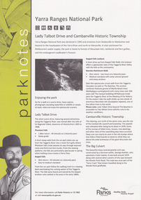
A flyer produced by Parks Victoria of information on Lady Talbot Drive and Cambarville Historic Township.A flyer produced by Parks Victoria of information on Lady Talbot Drive and Cambarville Historic Township. Lady Talbot Drive a 24 kilometer scenic rainforest car journey which passes a number of walks and waterfalls in the Yarra Ranges National Park. Lady Talbot Drive is named after Lady Sarah Elizabeth, the wife of Sir Reginald Talbot, who was the Governor of Victoria from 25th April, 1904 to 6th July 1908. Cambarville is notable for its giant mountain ash (Eucalyptus regnans) trees within the Cumberland Memorial Scenic Reserve, and relics from former sawmills and gold mining. The Big Culvert is located nearby on the Marysville-Woods Point Road, which was historically part of the Yarra Track. Cambarville was established as a timber mill town in the 1940s. Timber mill owners A Cameron and FJ Barton named Cambarville. They established the mill to salvage timber from trees destroyed in the 1939 bushfires. Cambarville was impacted by the 2009 Black Saturday bushfires and any remaining structures were destroyed. parks victoria, yarra ranges national park, lady talbot drive, lady talbot forest drive, cambarville, taggerty river, sir reginald talbot, lady sarah elizabeth talbot, phantom falls, keppel falls, keppel falls lookout, beeches rainforest walk, big culvert, cumberland walk, the big tree, the sitka spruce, cora lynn falls, sovereign view -
 Mt Dandenong & District Historical Society Inc.
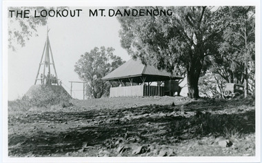
Photograph, The Lookout Mt Dandenong, c1920s
Mount Dandenong Trig Station c1920s.mount dandenong, trig point -
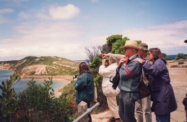 Churchill Island Heritage Farm
Photograph - Photograph of people looking over shoreline
Churchill Island Heritage Farm has a large collection of photographs dating from the nineteenth century. Photograph of a group of people looking and pointing across the water at Pinnacle Lookout, Woolamaicatalogue number written on reverse in pencilchurchill island, photograph, woolamai, pinnacle lookout -
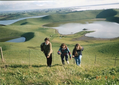 Ballarat Heritage Services
Photograph - Photograph - Colour, Kathleen Gervasoni, Red Rock, Alvie, 1989, 02/09/1989
Red Rock, Alvie, near Colac, is a complex of approximately 30 volcanic eruption points and is the Southern most of a chain of three volcanoes, the others being Warrion Hill and Alvie Hill. It is arguably the youngest eruption point in Victoria at around 8000 years, especially since the age of Mt Napier has been progressively pushed back. The highest point (on the Northern side) has many interesting features, including some awesome spatter ramparts. Driving around the rim to the south, you can also see layered tuff. There are some good views out to Lake Corangamite and the lava flows (probably from Warrion Hill) can be seen where they have entered the lake. Most of Red Rock is in private land, with two lookout points with some interpretive information. The water depicted in this photograph is not evident in 2019. Type: Volcanic Complex Location: South of Alvie, Victoria Last Eruption: 8000 years ago Access: Mostly private land, but there is an access road and some interpretive signage Visited: Visited Colour photograph of sisters Clare Gervasoni (left), Ann Gervasoni (centre) and Lisa Gervasoni and Red Rock, Alvie clare gervasoni, lisa gervasoni, ann gervasoni, red rock alvie -
 Glenelg Shire Council Cultural Collection
Negative - Negative - Dutton's Lookout, Portland, c. 1934
... Lookout, Portland Negative Negative for black and white photograph ...Negative for black and white photograph. View from Dutton's Lookout, Portland, looking east. Ocean Pier, Railway Pier, Fishermen's Breakwater, Battery Point, Lawrence Rocks.duttons lookout, negative, portland, coast -
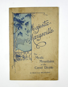 Marysville & District Historical Society
Booklet, Marysville Tourist Association, Magestic Marysville-The Mystic Mountains of the Great Divide, 1920's
An information guide of day trips to attractions in and around Marysville in Victoria. This booklet was produced by the Marysville Tourist Association.Paperback. Cover is beige with a drawing of two people standing next to a car looking at the view. The title is in dark blue across the front.non-fictionAn information guide of day trips to attractions in and around Marysville in Victoria. This booklet was produced by the Marysville Tourist Association.marysville, victoria, marysville tourise association, steavenson falls, keppel falls, cameron cascades, cumberland, mt cathedral, eildon, snob's creek falls, wolfram mine, mt strickland, keppel's lookout, mt kitchener, mt edgar, mt gordon, nichol's lookout, michael dene, beauty spot, gilbert's gully, taggerty river, wood's point -
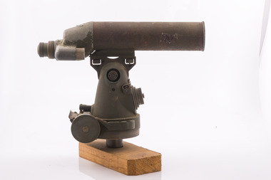 Forests Commission Retired Personnel Association (FCRPA)
Telescope used in FCV fire towers - ex military, c 1940s
Victoria once had well over one hundred fire lookouts and firetowers. Fire lookouts, or observation posts, were often just a clearing on a hill or a vantage point, whereas firetowers were definite structures. Many were established by the Forests Commission Victoria (FCV) in the 1920s, but the network was expanded rapidly in response to recommendations of the Stretton Royal Commission after the 1939 Black Friday bushfires. When a fire or smoke was spotted from the tower a bearing was taken with the alidade and radioed or telephoned into the district office. It was then cross referenced with bearings from other towers on a large wall map to give a "fix" on the fire location Alidades and telescopes were used in the post war period but were replaced with a much simpler map table and reference string suspended from the centre of the tower cabin.Uncommon usageTelescope used in fire towers Ex military Kern Company NY Argus made in USA Adjustment lens, dials and focus ring Small spirit levelbushfire -
 Forests Commission Retired Personnel Association (FCRPA)
Alidade - sight tube used in FCV fire towers, c 1940s
Victoria once had well over one hundred fire lookouts and firetowers. Fire lookouts, or observation posts, were often just a clearing on a hill or a vantage point, whereas firetowers were definite structures. Many were established by the Forests Commission Victoria (FCV) in the 1920s, but the network was expanded rapidly in response to recommendations of the Stretton Royal Commission after the 1939 Black Friday bushfires. When a fire or smoke was spotted from the tower a bearing was taken with the alidade and radioed or telephoned into the district office. It was then cross referenced with bearings from other towers on a large wall map to give a "fix" on the fire location Alidades and telescopes were used in the post war period but were replaced with a much simpler map table and reference string suspended from the centre of the tower cabin.Uncommon usageAlidade Sight TubeFCV and bearing markers on the alloy base. Very simple design. bushfire -
 Forests Commission Retired Personnel Association (FCRPA)
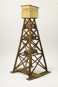
Wooden Model Fire Tower, Tom Coish, Model of Reef Hills fire tower, (5 km south of Benalla), 1957
Victoria once had well over one hundred fire lookouts and firetowers. Fire lookouts, or observation posts, were often just a clearing on a hill or a vantage point, whereas firetowers were definite structures. There are at least three categories of firetowers… (1) tree perches, (2) four-legged towers made of either wood or steel, as well as (3) hilltop cabins and observatories. Many were established by the Forests Commission Victoria (FCV) in the 1920s, but the network was expanded rapidly in response to recommendations of the Stretton Royal Commission after the 1939 Black Friday bushfires. The wooden towers were often built by bush craftsmen like legendary FCV overseer Clem Heather from Orbost. But advances in aerial reconnaissance and radio technology led to the gradual reduction in the number of fixed towers. FFMV now operates 72 firetowers. The CFA, Melbourne Water, Hancock Victorian Plantations (HVP) also operate some, the Army has one at Puckapunyal overlooking the live-firing range. Only two remaining fire towers of this design remain in Victoria (Mt Little Dick and Big Tower in the Mullungdung State Forest). Mt Nowa Nowa and Stringers Knob burnt down in the 2019/20 bushfiresLarge model of an Reef Hills fire tower. Presumably used for instructional purposes. Traditional FCV four legged design with three landings and closed cabin.bushfire -
 Marysville & District Historical Society
Ephemera (Item) - Programme of events, Marysville Tourist & Progress Association, Marysville Tourist and Progress Association Diary, 1963
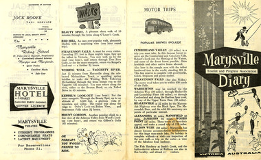
A programme of events taking place in January, 1963, published by the Marysville Tourist and Progress Association. 1963 was Marysville's centenary year. The Association was formed in November 1907 to promote tourism within the area. This included the physical creation of signage, parklands, roads and walks to various attractions. A programme of events taking place in January, 1963, published by the Marysville Tourist and Progress Association. 1963 was Marysville's centenary year.marysville, victoria, programme, marysville tourist and progress association, misslynn beauty salon, marysville garage, crossways cabaret, l.h. potter, marysville swimming pool, regal squab farm, bartons stores, fruit salad farm, percy postlethwaite, jock roofe taxi service, the marysville riding school, marysville hotel, marysville theatre, cumberland valley, steavenson falls, warburton, healesville, alexandra, mansfield, jamieson, wood's point, eildon weir, snob's creek, rubicon, beauty spot walk, red hill walk, wishing well, taggerty river, keppel's lookout, mount gordon -
 Marysville & District Historical Society
Ephemera (Item) - Tourist brochure, Victorian Government Tourist Bureau, Marysville Victoria Australia, Unknown
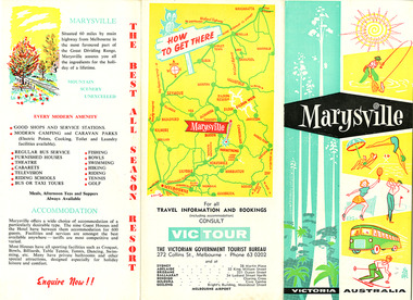
A tourist brochure on Marysville and the surrounding area published by the Victorian Government Tourist Bureau for the Marysville Tourist and Progress Association.A tourist brochure on Marysville and the surrounding area published by the Victorian Government Tourist Bureau for the Marysville Tourist and Progress Association.marysville, victoria, tourist brochure, victorian government tourist bureau, cumberland valley, cumberland falls, cora-lyn falls, robart's lookout, meeting of the waters, warburton, acheron way, healesville, launching place, reefton spur, upper yarra dam, maroondah highway, black spur, maroondah dam, alexandra, mansfield, jamieson, wood's point, eildon weir, snob's creek, rubicon, lake mountain, marysville tourist and progress association, the cumberland, kerami guest house, kooringa guest house, marylands guest house, marylyn guesthouse, marysville hotel, mount kitchener house, barton brothers' store, fruit salad farm, marysville dairy, marysville caravan park, marysville garage, marysville riding school, marysville theatre, mckenzie's tourist services, potters fruit and milk bar, arosa holiday cottages, scenic motel, beauty spot walk, red hill walk, wishing well, taggerty river, mount gordon, steavenson falls, keppel's lookout, keppel's falls -
 Marysville & District Historical Society
Ephemera (Item) - Tourist brochure, Victorian Government Tourist Bureau, Marysville Victoria Australia, Unknown
A tourist brochure on Marysville and the surrounding area published by the Victorian Government Tourist Bureau for the Marysville Tourist and Progress Association.A tourist brochure on Marysville and the surrounding area published by the Victorian Government Tourist Bureau for the Marysville Tourist and Progress Association.marysville, victoria, tourist brochure, victorian government tourist bureau, cumberland valley, cumberland falls, cora-lyn falls, robart's lookout, meeting of the waters, warburton, acheron way, healesville, launching place, reefton spur, upper yarra dam, maroondah highway, black spur, maroondah dam, alexandra, mansfield, jamieson, wood's point, eildon weir, snob's creek, rubicon, lake mountain, marysville tourist and progress association, the cumberland, kerami guest house, kooringa guest house, marylands guest house, marylyn guesthouse, marysville hotel, mount kitchener house, barton brothers' store, fruit salad farm, marysville dairy, marysville caravan park, marysville garage, marysville riding school, marysville theatre, mckenzie's tourist services, potters fruit and milk bar, arosa holiday cottages, scenic motel, beauty spot walk, red hill walk, wishing well, taggerty river, mount gordon, steavenson falls, keppel's lookout, keppel's falls -
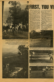 Marysville & District Historical Society
Newspaper (Item) - Newspaper article, FIRST, YOU VISIT THE FALLS, Unknown
A newspaper article on some of the local attractions and activities to be seen and done in and around Marysville.A newspaper article on some of the local attractions and activities to be seen and done in and around Marysville.marysville, victoria, australia, newspaper article, steavenson falls, beauty spot walk, red hill walk, wishing well, taggerty river, mount gordon, keppel's lookout, keppel falls, old water wheel, cumberland valley, lake eildon, snob's creek fish hatchery, alexandra, mansfield, jamieson, wood's point, warburton, healesville -
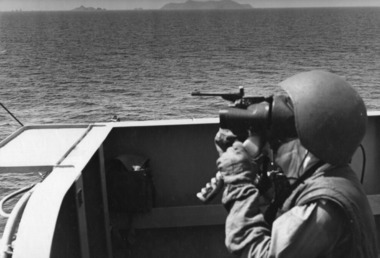 National Vietnam Veterans Museum (NVVM)
Photograph - B&W image
Denis Gibbons (1937 – 2011) Trained with the Australian Army, before travelling to Vietnam in January 1966, Denis stayed with the 1st Australian Task Force in Nui Dat working as a photographer. For almost five years Gibbons toured with nine Australian infantry battalions, posting compelling war images from within many combat zones before being flown out in late November 1970 after sustaining injuries. The images held within the National Vietnam Veterans Museum make up the Gibbons Collection.A black and white photograph of a crew member keeping lookout on a deck of HMAS Hobart during a fire mission into Vinh, a major choke point in North Vietnam, where convoys were formed for the move into South Vietnam. A forward air controller from USS Hancock was directing the fire from the air.photograph, hmas hobart, vinh, uss hancock, tonkin gulf, 7th fleet, gibbons collection catalogue, denis gibbons, photographer, vietnam war