Showing 56 items matching "lot 24"
-
 Whitehorse Historical Society Inc.
Legal record - Land Title, Certificate of Title, 29/08/1922 12:00:00 AM
... ...Lot 24...Certificate of Title, mortgage details and rate notices for Lot 24 Myrtle Grove, Blackburn owned by Alfred samuel Wright....Whitehorse Historical Society Inc. 2-10 Deep Creek Road Mitcham melbourne Wright Alfred samuel Certificates Myrtle Grove Blackburn Lot 24 Laburnum Street Blackburn Certificate of Title, mortgage details and rate notices for Lot 24 Myrtle Grove, Blackburn owned by Alfred samuel Wright. ...Certificate of Title, mortgage details and rate notices for Lot 24 Myrtle Grove, Blackburn owned by Alfred samuel Wright.Certificate of Title, mortgage details and rate notices for Lot 24 Myrtle Grove, Blackburn owned by Alfred samuel Wright.Certificate of Title, mortgage details and rate notices for Lot 24 Myrtle Grove, Blackburn owned by Alfred samuel Wright.wright, alfred samuel, certificates, myrtle grove, blackburn, lot 24, laburnum street, blackburn -
 Ringwood and District Historical Society
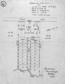
Map - Design for Subdivision, Part of Crown Allotment 33, Parish of Warrandyte, County of Evelyn, Lot 24 Mullum Mullum Road, Ringwood, Victoria
... Part of Crown Allotment 33, Parish of Warrandyte, County of Evelyn, Lot 24 Mullum Mullum Road, Ringwood, Victoria....Part of Crown Allotment 33, Parish of Warrandyte, County of Evelyn, Lot 24 Mullum Mullum Road, Ringwood, Victoria. ...Diagram showing layout and dimensions of 23 allotments on Mullum Mullum Road and un-named streets, later The Centreway and Wattle Avenue, Ringwood. LP3820 (9-2-1929).Donald Fraser, Licensed Surveyor, Heidelberg - 11/12/1924 -
Ringwood and District Historical Society
Legal record - Conditions of Sale (C.E.Carter), Ringwood - Lot 24 , Plan of Subdivision No 3820, C Dobbin to Unstated Purchaser, 1928
... Ringwood - Lot 24 , Plan of Subdivision No 3820, C Dobbin to Unstated Purchaser, 1928...Ringwood and District Historical Society 125A Warrandyte Road Ringwood North melbourne Particulars and Conditions of Sale of Property , from Charlotte Dobbin to Unstated Ringwood - Lot 24 , Plan of Subdivision No 3820, C Dobbin to Unstated Purchaser, 1928 Legal record Conditions of Sale (C.E.Carter) ...Particulars and Conditions of Sale of Property , from Charlotte Dobbin to Unstated -
Save the Dandenongs League Inc.
Archive (item), Save the Dandenongs League Incorporated, PE98/00695 - Ashmore - Lot 23 & 24 (No. 82) - The Crescent Kallista
... PE98/00695 - Ashmore - Lot 23 & 24 (No. 82) - The Crescent Kallista...PE98/00695 - Ashmore - Lot 23 & 24 (No. 82) - The Crescent Kallista Archive Save the Dandenongs League Incorporated ... -
 Mt Dandenong & District Historical Society Inc.
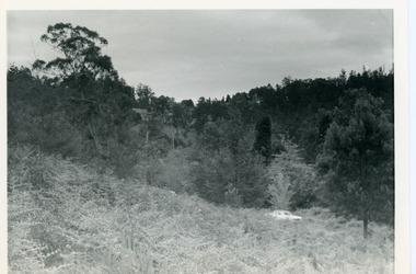
Photograph, View Up Valley Towards Kalorama Gap 1973
... 1973 View up Valley towards Kalorama Gap from what was Crooks LOT 24. White car is on Barbers Road and site of “Kia Ora” is to right of it....Kalorama Kalorama Gap Five Ways Barbers Road George Barber Kia-Ora 1973 View up Valley towards Kalorama Gap from what was Crooks LOT 24. White car is on Barbers Road and site of “Kia Ora” is to right of it. ...John Lundy-Clarke grew up in the Kalorama/Mt Dandenong area and later in life (1972-74) began to write a comprehensive history of the area working from an original settlement map in an effort to cover all areas. This photograph would have been taken to show the changes in the area over the years. Kalorama Gap is now called Five Ways. 'Kia-Ora ' was a guest house built by George Barber. It is no longer standing.Black and white photograph showing a bush scene with a white car visible on the right. Handwritten inscription on reverse by John Lundy-Clarke1973 View up Valley towards Kalorama Gap from what was Crooks LOT 24. White car is on Barbers Road and site of “Kia Ora” is to right of it.kalorama, kalorama gap, five ways, barbers road, george barber, kia-ora -
 Ringwood and District Historical Society
Map, Parish Map including Bulleen, Nunawading, and eventual site of Ringwood. c1855
... Note on rear of backing sheet: "Ringwood is south of Lots 23 & 24, RHS....Note on rear of backing sheet: "Ringwood is south of Lots 23 & 24, RHS. Black and white copy of part of Parish Map collection. ...Black and white copy of part of Parish Map collection. Volume 3, Folio 105.Note on rear of backing sheet: "Ringwood is south of Lots 23 & 24, RHS. -
Whitehorse Historical Society Inc.
Map, Anjaya Court, Blackburn, ca1970
... [Plan of] Anjaya Court, Blackburn, Lots 6 - 20and of Leons Court, Lots 21-24. One copy with proposed sewerage plan....Whitehorse Historical Society Inc. 2-10 Deep Creek Road Mitcham melbourne Anjaya Court Blackburn Land Subdivision Sewerage and sanitation [Plan of] Anjaya Court, Blackburn, Lots 6 - 20and of Leons Court, Lots 21-24. One copy with proposed sewerage plan. ...[Plan of] Anjaya Court, Blackburn, Lots 6 - 20and of Leons Court, Lots 21-24. One copy with proposed sewerage plan.anjaya court, blackburn, land subdivision, sewerage and sanitation -
 Mt Dandenong & District Historical Society Inc.
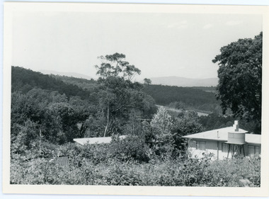
Photograph, View From Ernest Road To Site Of "Kia-Ora"
... View 1973 from corner of Ernest Rd and Outlook Drive Lot 24 Village Settlement looking over the site of “Kia Ora” to the pioneers clearings. ...Ernest Road John Lundy-Clarke Kia=Ors Guest House guesthouse View 1973 from corner of Ernest Rd and Outlook Drive Lot 24 Village Settlement looking over the site of “Kia Ora” to the pioneers clearings. ...John Lundy-Clarke grew up in the Kalorama/Mt Dandenong area and later in life (1972-74) began to write a comprehensive history of the area working from an original settlement map in an effort to cover all areas. The photograph taken c1973 from Ernest Road looks over the site of the Kia-Ora guesthouse which is marked by the oalm tree that can be seen at the front of the flat roof close to the gum tree trunk. Situated on Barber’s Road, ‘Kia-Ora’ was built in 1912 by George Barber. It was later leased by a Mrs Pemberthy. “Kia-Ora’ was one of four places connected when the telephone was brought into the district in 1912. The other places were ‘Mountjoy’, ‘Cherry Farm’ and ‘Callum House’. ‘Kia-Ora’ was burnt down in 1924.Black and white photograph showing a house with water tank in right foreground and another flat roof centre foreground. There is a handwritten description by John Lundy-Clarke on the reverse.View 1973 from corner of Ernest Rd and Outlook Drive Lot 24 Village Settlement looking over the site of “Kia Ora” to the pioneers clearings. The palm tree seen above the flat roof (Rex) on left, is on the exact site of “Kia Ora”. Photo JLCernest road, john lundy-clarke, kia=ors, guest house, guesthouse -
 Bendigo Military Museum
Card - GREETING CARD, Raphael Tuck & Sons Ltd London, C.WW1
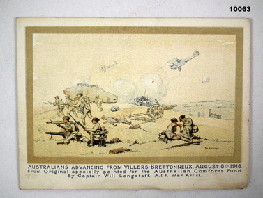
... On back also Greetings from "Bill, with Lots of Love" 24 May 1919 and a message on side....Inscribed greetings from "Bill, with Lots of Love" 24 May 1919. Written message on side "I hope you are well Mother Dear as this leaves me, Bill"....On back also Greetings from "Bill, with Lots of Love" 24 May 1919 and a message on side. ...Greetings card from Bill with WW1 theme with pictures of two WW1 Battles. Part of V.E. Giudice, No. 53730. Collection part of Cat No. 10031P. Overall part of Bill Thomason Collection, Cat No. 4136P.Fold over greeting card. Cream colour. Page 1 has a picture of a painting of Australians advancing at Villers-Bretonneux on Aug 8th 1918. Page two has a description of the battle. Page 3 is a painting of the capture of Hamel Village and page 4 was description of that battle. On back also Greetings from "Bill, with Lots of Love" 24 May 1919 and a message on side.Inscribed greetings from "Bill, with Lots of Love" 24 May 1919. Written message on side "I hope you are well Mother Dear as this leaves me, Bill".william (bill) thomason collection, greeting card, ww1 -
 Sunshine and District Historical Society Incorporated
Administrative record - City of Sunshine - Commissioner Mr Alexander Alex George Gillon Collection 1976 - 1982 - Extraordinary business 27th June 1981, City of Sunshine, 27th June 1981
... Proposed Traffic Signals Graham Street and Wright Street intersection Height of Fence Lot 24 Geelong Road Footscray West Location of Building 19 Hillside Crescent Maribyrnong Location of Building 18 Ambon Avenue Deer Park Building Over Easement Lot 89 Donald Street Sunshine...Graham Street Wright Street Sunshine Geelong Road Footscray West Hillside Crescent Maribyrnong Ambon Avenue Deer Park Donald Street Proposed Traffic Signals Graham Street and Wright Street intersection Height of Fence Lot 24 Geelong Road Footscray West Location of Building 19 Hillside Crescent Maribyrnong Location of Building 18 Ambon Avenue Deer Park Building Over Easement Lot 89 Donald Street Sunshine Foolscap sized document. ...Proposed Traffic Signals Graham Street and Wright Street intersection Height of Fence Lot 24 Geelong Road Footscray West Location of Building 19 Hillside Crescent Maribyrnong Location of Building 18 Ambon Avenue Deer Park Building Over Easement Lot 89 Donald Street Sunshinegraham street, wright street, sunshine, geelong road, footscray west, hillside crescent, maribyrnong, ambon avenue, deer park, donald street -
Whitehorse Historical Society Inc.
Document, Certificate of Title, 1925
... Certificates of Title vol.4999 fol. 999781, 28 May 1925, Lots 23 and 24 Laburnum Street Blackburn, owned by Belinda Augustus Louise Hazelwinkel, and vol. 5333 fol. 1066525, Lot 23 Laburnum Street Blackburn 25 October 1927, owned by City and Suburban Investments, mortgage and rates notices...Certificates of Title vol.4999 fol. 999781, 28 May 1925, Lots 23 and 24 Laburnum Street Blackburn, owned by Belinda Augustus Louise Hazelwinkel, and vol. 5333 fol. 1066525, Lot 23 Laburnum Street Blackburn 25 October 1927, owned by City and Suburban Investments, mortgage and rates notices...Whitehorse Historical Society Inc. 2-10 Deep Creek Road Mitcham melbourne Certificates of Title vol.4999 fol. 999781, 28 May 1925, Lots 23 and 24 Laburnum Street Blackburn, owned by Belinda Augustus Louise Hazelwinkel, and vol. 5333 fol. 1066525, Lot 23 Laburnum Street Blackburn 25 October 1927, owned by City and Suburban Investments, mortgage and rates notices Shire of Blackburn and Mitcham Hazelwinkel Belinda Augustus Louise Laburnum Street Blackburn Lots 23 and 24 City and Suburban Investments Ltd Land titles of Belinda Augustus Louise Hazelwinkel Certificates of Title vol.4999 fol. 999781, 28 May 1925, Lots 23 and 24 Laburnum Street Blackburn, owned by Belinda Augustus Louise Hazelwinkel, and vol. 5333 fol. 1066525, Lot 23 Laburnum Street Blackburn 25 October 1927, owned by City and Suburban Investments, mortgage and rates notices Certificate of Title Document Document ...Land titles of Belinda Augustus Louise HazelwinkelCertificates of Title vol.4999 fol. 999781, 28 May 1925, Lots 23 and 24 Laburnum Street Blackburn, owned by Belinda Augustus Louise Hazelwinkel, and vol. 5333 fol. 1066525, Lot 23 Laburnum Street Blackburn 25 October 1927, owned by City and Suburban Investments, mortgage and rates noticesLand titles of Belinda Augustus Louise Hazelwinkelshire of blackburn and mitcham, hazelwinkel, belinda augustus louise, laburnum street blackburn, lots 23 and 24, city and suburban investments ltd -
 Sunshine and District Historical Society Incorporated
Administrative record - City of Sunshine - Commissioner Mr Alexander Alex George Gillon Collection 1976 - 1982 - Notice of Special meeting of the council 12th January 1978, City of Sunshine, 6th January 1978
... Approval of tender for Tennis Courts Dempster Park including Albion Tennis Club contributions Land Use Permit Display village and subsequent cluster subdivision Station Road Land Use Permit Subdivision and detached house Robinsons Road Land Use Permit Sales and servicing of motorcycles 60A Monash Street Land Use Permit Two display homes and associated car parking Aycliff Drive and Phyllis Parade Land Use Permit Extension to existing primary school Lot 55 Churchill Avenue Land Use Permit Ornamental garden display and sales of domestic pets 553A and 553B Geelong Road Land Use Permit 5 Display homes Camelot Drive and Trafalgar Street Land Use Permit Soccer ground and sports club Selwyn Club Selwyn Street Land Use Permit Subdivision and detached houses Lot 1009 Tamar Drive Enforcement 34 Garnet Street panel beating and spray painting Land Use Permit Factory light engineering lot 45 Cromer Avenue Land Use Permit Poultry farming and dressed chicken sales and take away food premises 159 - 161 Rosamond Road Land Use Permit Flats Lot 9 Mernda Street Land Use Permit Extension to furniture sales buildings 85 - 91 Hampshire Road Land Use Permit Storage of soil and retail plant nursery Northwest corner Fairbairn Road and Boundary Road Land Use Permit Squash court Centre Rosamond Road Enforcement 2 Gregory Street bee keeping Land Use Permit Sand blasting and protective coasting Fairbairn Road Land Use Permit Flats Main Road West, Kodre Street and Washington Street Land Use Permit Store Lot 24 Cromer Avenue Land Use Permit Squash Court Complex lots 32. 33 & 34 Raleigh Road Land Use Permit Panel beating factory McIntyre Road Strata Subdivision 3 Bardsley Street Consolidation of Title 99 Couch Street Amenities Vans Tenders for installation of wheel wash at new tip Land Use Permit Flats Station Road...City of Sunshine Alexander "Alex" George Gillon Sunshine North Tennis Club Albion Tennis Club Dempster Park Phoenix Street Sunshine North Station Road Deer Park Robinsons Road Monash Street Sunshine Aycliff Drive Phyllis Parade Churchill Avenue Braybrook Christ The King Primary School Geelong Road Brooklyn Camelot Drive Trafalgar Street Albanvale Albion Rovers Soccer Club Selwyn Sports Club Selwyn Park Selwyn Street Albion Tamar Drive Garnet Street Cromer Avenue Rosamond Road Maribyrnong Mernda Street Sunshine West Hampshire Road Fairnbairn Road Boundary Road Gregory Street Main Road West Raleigh Road McIntyre Road Approval of tender for Tennis Courts Dempster Park including Albion Tennis Club contributions Land Use Permit Display village and subsequent cluster subdivision Station Road Land Use Permit Subdivision and detached house Robinsons Road Land Use Permit Sales and servicing of motorcycles 60A Monash Street Land Use Permit Two display homes and associated car parking Aycliff Drive and Phyllis Parade Land Use Permit Extension to existing primary school Lot 55 Churchill Avenue Land Use Permit Ornamental garden display and sales of domestic pets 553A and 553B Geelong Road Land Use Permit 5 Display homes Camelot Drive and Trafalgar Street Land Use Permit Soccer ground and sports club Selwyn Club Selwyn Street Land Use Permit Subdivision and detached houses Lot 1009 Tamar Drive Enforcement 34 Garnet Street panel beating and spray painting Land Use Permit Factory light engineering lot 45 Cromer Avenue Land Use Permit Poultry farming and dressed chicken sales and take away food premises 159 - 161 Rosamond Road Land Use Permit Flats Lot 9 Mernda Street Land Use Permit Extension to furniture sales buildings 85 - 91 Hampshire Road Land Use Permit Storage of soil and retail plant nursery Northwest corner Fairbairn Road and Boundary Road Land Use Permit Squash court Centre Rosamond Road Enforcement 2 Gregory Street bee keeping Land Use Permit Sand blasting and protective coasting Fairbairn Road Land Use Permit Flats Main Road West, Kodre Street and Washington Street Land Use Permit Store Lot 24 Cromer Avenue Land Use Permit Squash Court Complex lots 32. 33 & 34 Raleigh Road Land Use Permit Panel beating factory McIntyre Road Strata Subdivision 3 Bardsley Street Consolidation of Title 99 Couch Street Amenities Vans Tenders for installation of wheel wash at new tip Land Use Permit Flats Station Road Foolscap sized document. ...Approval of tender for Tennis Courts Dempster Park including Albion Tennis Club contributions Land Use Permit Display village and subsequent cluster subdivision Station Road Land Use Permit Subdivision and detached house Robinsons Road Land Use Permit Sales and servicing of motorcycles 60A Monash Street Land Use Permit Two display homes and associated car parking Aycliff Drive and Phyllis Parade Land Use Permit Extension to existing primary school Lot 55 Churchill Avenue Land Use Permit Ornamental garden display and sales of domestic pets 553A and 553B Geelong Road Land Use Permit 5 Display homes Camelot Drive and Trafalgar Street Land Use Permit Soccer ground and sports club Selwyn Club Selwyn Street Land Use Permit Subdivision and detached houses Lot 1009 Tamar Drive Enforcement 34 Garnet Street panel beating and spray painting Land Use Permit Factory light engineering lot 45 Cromer Avenue Land Use Permit Poultry farming and dressed chicken sales and take away food premises 159 - 161 Rosamond Road Land Use Permit Flats Lot 9 Mernda Street Land Use Permit Extension to furniture sales buildings 85 - 91 Hampshire Road Land Use Permit Storage of soil and retail plant nursery Northwest corner Fairbairn Road and Boundary Road Land Use Permit Squash court Centre Rosamond Road Enforcement 2 Gregory Street bee keeping Land Use Permit Sand blasting and protective coasting Fairbairn Road Land Use Permit Flats Main Road West, Kodre Street and Washington Street Land Use Permit Store Lot 24 Cromer Avenue Land Use Permit Squash Court Complex lots 32. 33 & 34 Raleigh Road Land Use Permit Panel beating factory McIntyre Road Strata Subdivision 3 Bardsley Street Consolidation of Title 99 Couch Street Amenities Vans Tenders for installation of wheel wash at new tip Land Use Permit Flats Station Road city of sunshine, alexander "alex" george gillon, sunshine north tennis club, albion tennis club, dempster park, phoenix street, sunshine north, station road, deer park, robinsons road, monash street, sunshine, aycliff drive, phyllis parade, churchill avenue, braybrook, christ the king primary school, geelong road, brooklyn, camelot drive, trafalgar street, albanvale, albion rovers soccer club, selwyn sports club, selwyn park, selwyn street, albion, tamar drive, garnet street, cromer avenue, rosamond road, maribyrnong, mernda street, sunshine west, hampshire road, fairnbairn road, boundary road, gregory street, main road west, raleigh road, mcintyre road -
 Sunshine and District Historical Society Incorporated
Administrative record - City of Sunshine - Commissioner Mr Alexander Alex George Gillon Collection 1976 - 1982 - Minutes of the special meeting of council held on 12th January 1978, City of Sunshine, 12th January 1978
... Approval of tender for Tennis Courts Dempster Park including Albion Tennis Club contributions Land Use Permit Display village and subsequent cluster subdivision Station Road Land Use Permit Subdivision and detached house Robinsons Road Land Use Permit Sales and servicing of motorcycles 60A Monash Street Land Use Permit Two display homes and associated car parking Aycliff Drive and Phyllis Parade Land Use Permit Extension to existing primary school Lot 55 Churchill Avenue Land Use Permit Ornamental garden display and sales of domestic pets 553A and 553B Geelong Road Land Use Permit 5 Display homes Camelot Drive and Trafalgar Street Land Use Permit Soccer ground and sports club Selwyn Club Selwyn Street Land Use Permit Subdivision and detached houses Lot 1009 Tamar Drive Enforcement 34 Garnet Street panel beating and spray painting Land Use Permit Factory light engineering lot 45 Cromer Avenue Land Use Permit Poultry farming and dressed chicken sales and take away food premises 159 - 161 Rosamond Road Land Use Permit Flats Lot 9 Mernda Street Land Use Permit Extension to furniture sales buildings 85 - 91 Hampshire Road Land Use Permit Storage of soil and retail plant nursery Northwest corner Fairbairn Road and Boundary Road Land Use Permit Squash court Centre Rosamond Road Enforcement 2 Gregory Street bee keeping Land Use Permit Sand blasting and protective coasting Fairbairn Road Land Use Permit Flats Main Road West, Kodre Street and Washington Street Land Use Permit Store Lot 24 Cromer Avenue Land Use Permit Squash Court Complex lots 32. 33 & 34 Raleigh Road Land Use Permit Panel beating factory McIntyre Road Strata Subdivision 3 Bardsley Street Consolidation of Title 99 Couch Street Amenities Vans Tenders for installation of wheel wash at new tip Land Use Permit Flats Station Road...City of Sunshine Alexander "Alex" George Gillon Sunshine North Tennis Club Albion Tennis Club Dempster Park Phoenix Street Sunshine North Station Road Deer Park Robinsons Road Monash Street Sunshine Aycliff Drive Phyllis Parade Churchill Avenue Braybrook Christ The King Primary School Geelong Road Brooklyn Camelot Drive Trafalgar Street Albanvale Albion Rovers Soccer Club Selwyn Sports Club Selwyn Park Selwyn Street Albion Tamar Drive Garnet Street Cromer Avenue Rosamond Road Maribyrnong Mernda Street Sunshine West Hampshire Road Fairnbairn Road Boundary Road Gregory Street Main Road West Raleigh Road McIntyre Road Approval of tender for Tennis Courts Dempster Park including Albion Tennis Club contributions Land Use Permit Display village and subsequent cluster subdivision Station Road Land Use Permit Subdivision and detached house Robinsons Road Land Use Permit Sales and servicing of motorcycles 60A Monash Street Land Use Permit Two display homes and associated car parking Aycliff Drive and Phyllis Parade Land Use Permit Extension to existing primary school Lot 55 Churchill Avenue Land Use Permit Ornamental garden display and sales of domestic pets 553A and 553B Geelong Road Land Use Permit 5 Display homes Camelot Drive and Trafalgar Street Land Use Permit Soccer ground and sports club Selwyn Club Selwyn Street Land Use Permit Subdivision and detached houses Lot 1009 Tamar Drive Enforcement 34 Garnet Street panel beating and spray painting Land Use Permit Factory light engineering lot 45 Cromer Avenue Land Use Permit Poultry farming and dressed chicken sales and take away food premises 159 - 161 Rosamond Road Land Use Permit Flats Lot 9 Mernda Street Land Use Permit Extension to furniture sales buildings 85 - 91 Hampshire Road Land Use Permit Storage of soil and retail plant nursery Northwest corner Fairbairn Road and Boundary Road Land Use Permit Squash court Centre Rosamond Road Enforcement 2 Gregory Street bee keeping Land Use Permit Sand blasting and protective coasting Fairbairn Road Land Use Permit Flats Main Road West, Kodre Street and Washington Street Land Use Permit Store Lot 24 Cromer Avenue Land Use Permit Squash Court Complex lots 32. 33 & 34 Raleigh Road Land Use Permit Panel beating factory McIntyre Road Strata Subdivision 3 Bardsley Street Consolidation of Title 99 Couch Street Amenities Vans Tenders for installation of wheel wash at new tip Land Use Permit Flats Station Road Foolscap sized document. ...Approval of tender for Tennis Courts Dempster Park including Albion Tennis Club contributions Land Use Permit Display village and subsequent cluster subdivision Station Road Land Use Permit Subdivision and detached house Robinsons Road Land Use Permit Sales and servicing of motorcycles 60A Monash Street Land Use Permit Two display homes and associated car parking Aycliff Drive and Phyllis Parade Land Use Permit Extension to existing primary school Lot 55 Churchill Avenue Land Use Permit Ornamental garden display and sales of domestic pets 553A and 553B Geelong Road Land Use Permit 5 Display homes Camelot Drive and Trafalgar Street Land Use Permit Soccer ground and sports club Selwyn Club Selwyn Street Land Use Permit Subdivision and detached houses Lot 1009 Tamar Drive Enforcement 34 Garnet Street panel beating and spray painting Land Use Permit Factory light engineering lot 45 Cromer Avenue Land Use Permit Poultry farming and dressed chicken sales and take away food premises 159 - 161 Rosamond Road Land Use Permit Flats Lot 9 Mernda Street Land Use Permit Extension to furniture sales buildings 85 - 91 Hampshire Road Land Use Permit Storage of soil and retail plant nursery Northwest corner Fairbairn Road and Boundary Road Land Use Permit Squash court Centre Rosamond Road Enforcement 2 Gregory Street bee keeping Land Use Permit Sand blasting and protective coasting Fairbairn Road Land Use Permit Flats Main Road West, Kodre Street and Washington Street Land Use Permit Store Lot 24 Cromer Avenue Land Use Permit Squash Court Complex lots 32. 33 & 34 Raleigh Road Land Use Permit Panel beating factory McIntyre Road Strata Subdivision 3 Bardsley Street Consolidation of Title 99 Couch Street Amenities Vans Tenders for installation of wheel wash at new tip Land Use Permit Flats Station Road city of sunshine, alexander "alex" george gillon, sunshine north tennis club, albion tennis club, dempster park, phoenix street, sunshine north, station road, deer park, robinsons road, monash street, sunshine, aycliff drive, phyllis parade, churchill avenue, braybrook, christ the king primary school, geelong road, brooklyn, camelot drive, trafalgar street, albanvale, albion rovers soccer club, selwyn sports club, selwyn park, selwyn street, albion, tamar drive, garnet street, cromer avenue, rosamond road, maribyrnong, mernda street, sunshine west, hampshire road, fairnbairn road, boundary road, gregory street, main road west, raleigh road, mcintyre road -
 Bendigo Military Museum
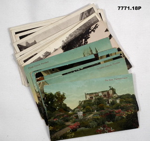
Postcard - POSTCARD, FARNHAM, U.K, Valentine's Series, cWW1
... 24 July 1918.' 13. Castle Street, Farnham. Handwritten in black ink on back. 'I think you will know where this is as I have told you quite a lot about Farnham, it is where Florrie is. ...24 July 1918.' 13. Castle Street, Farnham. Handwritten in black ink on back. 'I think you will know where this is as I have told you quite a lot about Farnham, it is where Florrie is. ...1. Florrie is a relative living in Farnham. 2. R.H. Baron married Elsie Keast in 1921. All cards relate to R.H. Baron's visits to Farnham whilst on leave to see Florrie. Part of the 'Robert H. Baron', no.3596 and Cooper Collection. See Catalogue No. 1981P for details of Baron's service.1. Coloured scene of a ruined castle and surrounding gardens. 2. Coloured scene of a garden with building and ruins in background. 3. Coloured photograph of a red brick building with battlement. 4. Coloured street scene with buildings, horse drawn transport and pedestrians. 5. Coloured photograph of the nave of a church looking towards the alter. 6. Coloured street scene with buildings and horse drawn transport. 7. Coloured view across a street to a white walled building with horse drawn transport. 8. Coloured photograph of a church, graveyard in foreground. 9. Black and white photograph of a castle surrounded by trees. 10. Black and white photograph of a forest scene with people standing on a bridge. 11. Black and white photograph of a street scene with buildings, horse drawn transport and people. 12. Black and white photograph of the tower of a church. Graveyard in the foreground. 13. Black and white photograph of a street scene with buildings, horse drawn transport and pedestrians. Castle on the hill in background. 14. Black and white photograph of a street scene with buildings, motor cars and pedestrians. 15. Black and white photograph of a street scene with buildings, motor cars, horse drawn transport and pedestrians. 16. Black and white photograph of a wooded valley. Houses on a hill in the background. 17. Black and white photograph of an avenue of trees. 18. Black and white photograph taken in a park. Three people standing on a bridge over a stream.1. The Keep, Farnham Castle. Handwritten in black ink on back: 'This is one of the pretty places around Farnham. I was all once here with Florrie. Bob' 2. In Castle grounds, Farnham. Handwritten in black ink on back: 'Dear Elsie, these are some places that visit... when I was down at Flories place. Bob xxxxxx' 3. Farnham Castle. 4. West Street, Farnham. 5. Parish Church, Farnham. 6. Castle Street, Farnham. 7. The Church House, Farnham. 8. Parish Church, Farnham. 9. Farnham Castle. 10. Red Hill Hanger, Farnham. Handwritten in black ink on back: 'Letter to R.H. Baron's sister - no date.' 11. South Street, Farnham. Handwritten in black ink on back: 'this part of the place I spent my leave at this is where Florrie is.' 12. Farnham Parish Church. Handwritten in black ink on back: 'Letter to R.H. Baron's mother - dated 24 July 1918.' 13. Castle Street, Farnham. Handwritten in black ink on back. 'I think you will know where this is as I have told you quite a lot about Farnham, it is where Florrie is. I spent my leave here. This is Castle Street and the castle is right on the top of the hill.' 14. Borough, Farnham. Handwritten in black ink on back. ' This is the place where Florrie lives. I spent my last leave their (sic), Bob.' 15. West Street, Farnham. Handwritten in pencil on back. 'Pte R.H. Baron, 57 Battalion, Australian Imperial Forces Abroad.' 16. Lower Bourne Valley, Farnham. Handwritten in black ink on back: 'Partial letter from R.H. Baron to his sweetheart.' 17. The Avenue, Farnham. Handwritten in black ink on back: 'Partial letter from R.H. Baron to his mother.' 18. Recreation Ground, Farnham. Handwritten in black ink on back: 'Letter to Doris from R.H. Baron - no date.' robert h. baron, cooper collection, postcards, farnham uk -
 Bendigo Military Museum
Document - INSTRUCTIONS, ARMY TRAINING, STEWARDS COURSE, Aust Army, unknown
... Lots of additions, prices and mistakes. 1. A4 size - culinary terms. RAASC Centre Puckapunyal - 5 pages. 2. Foolscap - Systems of food service. RAASC centre, Oct 1962 - 6 pages. 3. Foolscap - kitchen & personal hygiene, RAASC Centre Aug 1964 - 6 pages. 4. Foolscap - Mess Operation. RAASC Centre - 29 pages - Jan 1960. 5. A4 size - 1/71 Basic Stewards Course 3 Feb, 7-24 ...4. Mess Operation, setting of table, folding serviettes, tapping a keg of beer. 7. The prices will bring tears to your eyes, i.e. Packets of cigarettes 38 - 41 cents each.1. A4 size - culinary terms. RAASC Centre Puckapunyal - 5 pages. 2. Foolscap - Systems of food service. RAASC centre, Oct 1962 - 6 pages. 3. Foolscap - kitchen & personal hygiene, RAASC Centre Aug 1964 - 6 pages. 4. Foolscap - Mess Operation. RAASC Centre - 29 pages - Jan 1960. 5. A4 size - 1/71 Basic Stewards Course 3 Feb, 7-24 Feb 1971. GTF Area. 6. Single sheet ASCO Mess Requisition Form - N40A Dated 8/2/71. 7. 6 Task Force SGS Mess Stocktake and cash results.1. 3795952 Pte W.D. Patterson - has some ticks and pencilled changes. 2. 3795952 Pte W.D. Patterson. 3. 3795952 Pte W.D. Patterson. 4. 3795952 Pte W.D. Patterson. 5. Red ink amendments - dates & ticks. 6. ASCO form N.40A Mess requisition NR 67510 - Cannon Hill, Enogerra. 8/2/71. Sgts Mess Stocktake. 7. Lots of additions, prices and mistakes.messing, aust army -
 Bendigo Military Museum
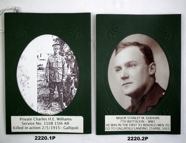
Photograph - WW1, WW2 PHOTOGRAPHS, three are c. 1914 - 18, one is c. 1940 - 1
... 24 years. Embark for Egypt 19.10.1914, embark for Gallipoli 12.4.1915, promoted Capt 26.4.1915, awarded MID for “Conspicious Gallantry and Services” between 25.4.1915 - 5.5.1915, WIA 8.5.1915 GSW to Foot, returned to Aust classed unfit for General Service, promoted Major 13.7.1917, returned to France July 1917, transferred to Senior Officers School England Oct 1917, hospitalised in November 1917 he then left England for Australia with effects of a dislocated knee on 24.1.1918, his appointment in the AIF terminated on 24.4.1918. He was one of the “First Lot...24 years. Embark for Egypt 19.10.1914, embark for Gallipoli 12.4.1915, promoted Capt 26.4.1915, awarded MID for “Conspicious Gallantry and Services” between 25.4.1915 - 5.5.1915, WIA 8.5.1915 GSW to Foot, returned to Aust classed unfit for General Service, promoted Major 13.7.1917, returned to France July 1917, transferred to Senior Officers School England Oct 1917, hospitalised in November 1917 he then left England for Australia with effects of a dislocated knee on 24.1.1918, his appointment in the AIF terminated on 24.4.1918. He was one of the “First Lot ....1) Charles Henry Ernest Williams No 1108 enlisted in the AIF in G Coy 15th Batt on 26.9.1914 age 29 years. Embarked for Egypt 22.12.1914, embark for Gallipoli 12.4.1915, KIA 2.5.1915, buried at Popes Hill. His body was later exhumed and buried in Quinns Post Cemetery. .2) Stanley Melville De Ravin had some 5 years military service prior to enlisting in the AIF on 24.8.1914 with the rank of Lieut in G Coy 7th Batt age 24 years. Embark for Egypt 19.10.1914, embark for Gallipoli 12.4.1915, promoted Capt 26.4.1915, awarded MID for “Conspicious Gallantry and Services” between 25.4.1915 - 5.5.1915, WIA 8.5.1915 GSW to Foot, returned to Aust classed unfit for General Service, promoted Major 13.7.1917, returned to France July 1917, transferred to Senior Officers School England Oct 1917, hospitalised in November 1917 he then left England for Australia with effects of a dislocated knee on 24.1.1918, his appointment in the AIF terminated on 24.4.1918. He was one of the “First Lot” of 93 men who volunteered in Bendigo. .3) Alfred R Williams No VX53411 enlisted in the 2nd AIF with 2/28th Batt on 21.4.1941 age 21 years. Promoted to Cpl he was KIA at El Alamein on 23.10.1942. .4) James Andrew Williams “MM” No 742 enlisted in the AIF in C Coy 40th Batt on 15.3.1916 age 29 years. Embark for England 1.7.1916, embark for France 30.9.1916, transfer to 15th Batt 13.10.1916, allotted Regt No 742A, hospital 26.1.1917 with Fracured Rib, rejoin unit 7.3.1917, WIA 11.4.1917 GSW left forearm severe remaining on duty for a short period, rejoin unit 16.7.1917, WIA 2nd occasion 26.9.1917 GSW neck and arm, during this action he was awarded the “Military Medal” at Zonnebeke, promoted Cpl 2.10.1917, rejoin unit 18.12.1917, WIA 3rd occasion 25.8.1918 Gassed, while recovering admitted with Diarrehoea 26.10.1918. After all this he gets himself into some trouble refusing a duty and is charged and reduced to the ranks. He disembarks in Melbourne on 13.11.1919 and discharged from the AIF on 14.1.1921..1) Copy - black and white photograph of soldier in uniform mounted in green cardboard folder. Private Charles H E WILLIAMS. Service details in black ink on paper. .2) Copy - black and white portrait photograph mounted in green cardboard folder. Major Stanley M De RAVIN. Information in black print on white paper. .3) Copy - black and white portrait photograph, solder in uniform mounted in green cardboard folder. Cpl Alfred R WILLIAMS. Information in black print on white paper. .4) Copy - black and white photograph soldier in uniform mounted in green cardboard folder. James Andrew WILLIAMS. Information in black print on white paper..1) In loving memory of great uncle Charles killed at Gallipoli may 20th 1915. From Jan Grose. .2) In loving memory Major Stanley M De RAVIN from I & J Grose .3) In loving memory of our uncle great uncle and great great uncle J.C. A. O Grose. .4) In loving memory of our grandfather great grandfather and great great grandfather J.C. A.O. Grosephotographs, oval, ww1 -
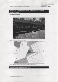 Eltham District Historical Society Inc
Document - Property Binder, 616 Main Road, Eltham; Plum Cottage
... 24 was reported in the Argus of 1923. Part of the Isherwood land was divided off and sold to Charles Stuart McNeil by May1955. Sometime in the period 1955-1960, the builder-designer, John Harcourt had created a pise house on the site, straddling the two subdivision lots. ...24 was reported in the Argus of 1923. Part of the Isherwood land was divided off and sold to Charles Stuart McNeil by May1955. Sometime in the period 1955-1960, the builder-designer, John Harcourt had created a pise house on the site, straddling the two subdivision lots. ...Plum Cottage is covered by Heritage Overelay HO256 in the Nillumbuk Planning Scheme This two-lot land holding was created as a subdivision and sold to Charles Stuart McNeil by May 1955. Sometime in the period 1955-1960, the builder-designer, John Harcourt had created a pise house on the site, straddling the two subdivision lots. The designer, John M. Harcourt was a pioneer builder in pise-de-terre and mudbrick in the Eltham Shire, Eltham being synonymous with alternative lifestyles and building practises until the onset of suburbia in the late 20th and early 21st centuries. This hipped-roof house is set high above Main Road on a V-shape plan characteristic of the Arts & Crafts style, with rammed earth or pise walls, timber joinery and a cement tiled roof. The V shape plan was used by important English and Eltham Arts & Crafts designers. The use of natural materials such as stone and timber construction is an essential part of the Arts & Crafts style and Harcourt’s work. So too is the application of the style on both the exterior and interior of the house as a holistic concept. The house adjoins the Lim Joon adobe house built and designed by Alistair Knox in the same era (HO119), thus forming a distinctive pair, both using an uncommon plan form. This house was identified in the Shire of Shire of Eltham Heritage 1992 as contributory to the Eltham Gateway Conservation Area, then proposed as an urban conservation area (now Heritage Overlay Area). Land Ownership Emily Jane Smith of 12 Woodside Street Fitzroy owned Crown Allotments 1 & 2 Sections 14, 27 by August 1918, selling to William Henry Smith of 12 Woodside Street, Nth Fitzroy May 1921. (John) James Isherwood of Main Road, Eltham owned the property by 1928 (the year of his death) with the beneficiary of his estate and next owner of this site being his widow, Minnie Maria Isherwood of Cemetery Road, Eltham. His holding in Main Road included parts of what was described in rate records as allotments1 & 2 Section E6. In the late 1930s, early 1940s her son Alfred John Isherwood was also rated for the land around this site, with the rated nett annual value varying between £2 and £5. Alfred Isherwood also lived at Main Road, Eltham with his wife Ellen: her early death at the age of 24 was reported in the Argus of 1923. Part of the Isherwood land was divided off and sold to Charles Stuart McNeil by May1955. Sometime in the period 1955-1960, the builder-designer, John Harcourt had created a pise house on the site, straddling the two subdivision lots. The house is visible on an aerial photograph from 1960s. Reputedly the house was called Plum Cottage and erected for Harcourt’s mother-in-law. A garage was added in 1959. Charles McNeil died in1971 aged 87: he was the son of Don McNeil and Margaret Arkell. Available rate records from the construction era start in the of the 1970s (1972-3) and list Mr H.C. & M/S A.V. Charity at 616 Main Road Eltham of this property with a nett annual value of $740. More recent valuer's data describes the property as lots 1 & 2 LP25668, located in the Central Riding of Eltham Shire, owned by Ann Valerie Charity and later, in 1990, by the Chincarini family. Building Description This hipped roof 11 .5 square house is set high above Main Road on a characteristic-shape plan and has rammed earth or pise walls, timber joinery and a cement tiled roof. The V-shape plan was used by Important designers such as C.F.A. Voysey (UK) who interpreted medieval domestic architecture as part of the Arts & Crafts style of the late 19th and early 20th centuries. The pise walls are covered with a textured render while the cement roofing tiles are also seen in the Harcourt Hill examples. Reputedly the ceiling joists are of a deep section and span long lengths with no need for hanging beams in the roof space. The ceilings are low and panelled in main rooms with apparently Caneite soft board infill panels between the exposed ceiling beams. These are painted white but may have been stained at one time. The focus of the house is the large living area with its vast random stone fireplace. Significance Plum Cottage is significant to the locality of Eltham because: Historically: • Plum Cottage is closely associated with the important historical theme of earth construction evident in Eltham and elsewhere in the Shire since theear1y Arts & Crafts inspired creations at Penleigh Boyd's The Robins (1912, HO101) and those at Montsalvat (1934-, HO82) but more prominent from the Second War period when earth building in Eltham was promoted in national periodicals as an alternative building method that avoided the building materials shortages of that era; • The choice of the earth building technique also expresses the theme of refuge or alternative living, synonymous with Eltham in the early to mid 20th century; • as a good example of domestic architecture from John Harcourt who was the first major post Second War figure in an important phase of Eltham’s earth building development, using his characteristic Old English or Arts& Crafts style that relies in this case on the pise wall construction, pitched roof forms, exposed ceiling joists, half timbering, random stonework, and panelled internal wall finishes. Architecturally: • Plum Cottage's pise wall construction is uncommon among the early earth-walled structures in the Shire, that are mainly of adobe or mud brick, and as a building material is uncommon among the Shire’s suburban dwellings generally which are clad typically with either fired clay bricks or timber boarding. Aesthetically: • Plum Cottage is a good and well preserved example of a modern Old English or Arts & Crafts style earth-walled building in the Shire • For the proximity of the significant Lim Joon adobe house designed by Alistair Knox adjoining to the north, providing a distinctive earth wall house pair, with uncommon plan forms. Reference Heritage Assessment of Plum Cottage, 616 Main Road, Eltham; Graeme Butler & Associates 2010main road, eltham, property, houses, (john) james isherwood, alfred john isherwood, ann valerie charity, arts and crafts style, charles stuart mcneil, chincarini family, eltham gateway zone, emily jane smith, h.c. charity, heritage assessment, john harcourt, john m. harcourt, lim joon house, main road eltham, minnie maria isherwood, pise construction, plum cottage -
 Eltham District Historical Society Inc
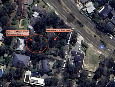
Document - Property Binder, 338 Main Road, Lower Plenty (also 37 Rangeview Road), March 2025
... 24 September 1984 5. Certificate of Title, Vol. 9581 Fol. 583 - Issued to Paul Robert Biber and Althea Constance Biber of 139 Lower Heidelberg Road, Ivanhoe for Lot 3 on Plan of Subdivision No. 23911, part of Crown Portion Two, Parish of Nillumbik, County of Evelyn, 24 September 1984. ...24 September 1984 5. Certificate of Title, Vol. 9581 Fol. 583 - Issued to Paul Robert Biber and Althea Constance Biber of 139 Lower Heidelberg Road, Ivanhoe for Lot 3 on Plan of Subdivision No. 23911, part of Crown Portion Two, Parish of Nillumbik, County of Evelyn, 24 September 1984. ...EDHS_03095-338 | EDHS_08635-37 338 Main Road Lower Plenty | 37 Rangeview Road, Lower Plenty Original Mudbrick cottage and studio designed and built by Eltham artist, David Alan Newbury See also EDHS_06090 David Newbury (Artist) David Newbury was married to Clare Margaret Newbury. According to the 1954 Electoral Roll they were living at 36A Murphy Street, South Yarra however around 1953 they purchased Lots 3 and 4 of Main Road Lot Plan LP 23911 in Lower Plenty. A building permit, No. 71, was issued 8 December 1953 for a 5-room house of Vertical Board construction, cost £2,840, builder L. Williams, owner D. Newbury of 36 Murphy Cl., South Yarra. The large house was in fact mostly built of mudbrick, the construction method was only just becoming recognised as an acceptable form in the late 1940s for issuance of a building permit. The house was commenced in 1954, designed by David Newbury and built by David Newbury, Horrie Judd and others. Information from Newbury family friends suggests that a second mudbrick building was constructed in the late 1950s, early 1960s for use as an artist studio by Newbury. The building was connected directly to the water mains at the time and was made suitable for living accommodation during the period Newbury was teaching at Bendigo. Apparently he and Claire rented out the main house during their time in Bendigo and would reside in the studio when visiting Melbourne. No permit for this studio was found in the Building Permit Register, Shire of Eltham, 1949-1960. The last recorded entries in the register are dated May 1960. This would suggest that the studio was constructed post May 1960. It is believed the studio was constructed during the latter period of Newbury’s teaching post in Bendigo so possibly late 1960/1961. In 1963 the Newbury’s address in the Electoral Roll has the property recorded as 220 Main Road, Lower Plenty. Between 1967 to 1980 the Electoral Rolls record the property as 338 Main Road. Today the address is 37 Rangeview Road, Lower Plenty. Contents: 1. Extract from 1942 Shire of Eltham Rate Book. Muriel Gladys Reitsma listed as owner 2. Extract from 1984-85 Shire of Eltham Rate Book for Rangeview Road. (No mention of No. 37 so was probably still listed as 338 Main Road.) 3. Certificate of Title, Vol. 5601 Fol. 1120089 - Issued to David James Graham of Lower Plenty, Builder, Heidelberg for Lot 32 Block B on Plan of Subdivision No. 7606, part of Crown Portion Two, Parish of Nillumbik, County of Evelyn, 29 October 1929 4. Certificate of Title, Vol. 8008 Fol. 076 - Issued to David Alan Newbury of 36 Murphy Street, South Yarra, School Teacher for Lot 3 on Plan of Subdivision No. 23911, part of Crown Portion Two, Parish of Nillumbik, County of Evelyn, 29 October 1953. Amended 24 June 1963 to transfer portion for road widening scheme per Country Roads Board Plan 6889 - Cancelled 24 September 1984 5. Certificate of Title, Vol. 9581 Fol. 583 - Issued to Paul Robert Biber and Althea Constance Biber of 139 Lower Heidelberg Road, Ivanhoe for Lot 3 on Plan of Subdivision No. 23911, part of Crown Portion Two, Parish of Nillumbik, County of Evelyn, 24 September 1984. Derived from Vol. 8008 Fol. 076 L276994V - Cancelled 20 Nov 1992 when subdivided from one to two lots in Vol 10092 Fol. 192 and Vol. 10092 Fol. 193; LP222467B 6. Certificate of Title, Vol. 10092 Fol. 192 - Transfer to Lawrie Mein of 20 Dewar Drive, Hurstbridge of Lot 1 on Plan of Subdivision No. 222467B, lodged 17 Feb 1993, Registered 29 March 1996. Parent Titles Vol 08008 Fol 077, Vol 09581 Fol 583 7. Survey Field Notes of Part of Crown Portion 2, Parish of Nillumbik, County of Evelyn - Portion of land bounded by New Eltham Road. Application 23911 dated 8 Sep 1952 with appended Surveyor Field notes per Application 7098; R.D. Steele, Licensed Surveyor, 18 August 1950 8. Survey Field Notes of Part of Crown Portion 2, Parish of Nillumbik, County of Evelyn - Portion of land bounded by Main Road and Rangeview Road; 2 Lot subdivisions, Vol. 9581 Fol. 583 Part Lot 3 on LP 23911 and Vol. 8008 Fol, 077 Lot 4 on LP 23911; Application 221805 dated 27 November 1989; W.J. Goodison, Licensed Surveyor, and attached Surveyor's Report dated 6 June 1990 (Withdrawn) 9. Survey Field Notes of Part of Crown Portion 2, Parish of Nillumbik, County of Evelyn - Portion of land bounded by Main Road and Rangeview Road; 2 Lot subdivisions, Vol. 9581 Fol. 583 Part Lot 3 on LP 23911 and Vol. 8008 Fol, 077 Lot 4 on LP 23911; Application 222467 dated 20 November 1992 (221805 resubmitted); W.J. Goodison, Licensed Surveyor, and attached Surveyor's Report dated 6 June 1990 Notes: Items 1 to 6 donated electronically Items 7 to 9 sourced from LASSI - SPEAR, Department of Transport and Planning, Victoria State Government, https://maps.land.vic.gov.au/lassi/SpearUI.jsp main road, property, mudbrick, david newbury, phoebe mason collection, rate books, shire of eltham, certificate of title, survey plan, 37 rangeview road, 338 main road, application 23911, lower plenty, map, surveyor field notes, application 221805, application 222467 -
 Eltham District Historical Society Inc
Photograph, Jim Connor, Eltham - Montmorency Uniting Church, 810 Main Rd, Eltham, 10 July 2023
... 24 acres bounded by Mount Pleasant Road and Pitt Street. From there they moved to a slab and bark hut in 1855 (this later served as the first school run by David Clark prior to the building of a new school in Dalton Street) and the members then built a chapel in 1858 on Lot 20, Henry Street (later to become the Rechabite Hall and Eltham Public Hall). ...24 acres bounded by Mount Pleasant Road and Pitt Street. From there they moved to a slab and bark hut in 1855 (this later served as the first school run by David Clark prior to the building of a new school in Dalton Street) and the members then built a chapel in 1858 on Lot 20, Henry Street (later to become the Rechabite Hall and Eltham Public Hall). ...Located on the corner of Main Road and John Street, the church first served the community as the Eltham Wesleyan Church since 1881. It became the Eltham Methodist Church in 1902, the year it united with the Primitive Methodists. Eltham Wesleyans first worshipped together in the home of William and Mary Crozier, on 24 acres bounded by Mount Pleasant Road and Pitt Street. From there they moved to a slab and bark hut in 1855 (this later served as the first school run by David Clark prior to the building of a new school in Dalton Street) and the members then built a chapel in 1858 on Lot 20, Henry Street (later to become the Rechabite Hall and Eltham Public Hall). The present church on John Street was designed by architects Crouch and Wilson in the Early English Gothic style with biochrome brick window frames, buttress heads and pinnacle. Church member George Stebbing built the church, the foundations were constructed with stone from the walls of the first Eltham State Primary School (No. 209) building which collapsed in 1874 and were purchased by Robert David Taylor. Stebbing was also responsible for building St Margaret’s Church and Shillinglaw Cottage. The Roll of Honour, which presently hangs in the church hall (which also doubles as the Opportunity Shop) lists 27 members of the congregation who served in the First World War, 11 of whom never returned. The red-brick Church Hall was opened in 1931 and in 1971 further additions linked the hall and church, including a foyer, vestry, meeting room and toilets reflecting the Eltham style of that time with its simplicity, extensive clear glass, reused baked clay-bricks from the 1881 church, heavy ceiling beams and compressed straw ceiling. On June 26, 1977, the church became part of the new Uniting Church in Australia consisting of the former Methodist and Congregational and most of the Presbyterian Churches. Following of declining numbers of worshippers, the church merged with the Montmorency Uniting Church on June 23, 1996. In 2023 the Uniting church approved a plan to renovate the church. It is understood that the historic church and the hall will be retained, and the building added in 1971 is to be demolished, to make way for a new purpose-built Opportunity shop. The proposed areas to be demolished include the current foyer, toilets, crèche, etc, including the area between the hall and the former RSL. Works are expected to commence mid to late July 2023. The Society was invited by a church member to take photographs of these areas to document them prior to demolition works commencing. Ref: “Nillumbik Now and Then” by Marguerite Marshall (2008)jim connor collection, 2023-07-10, eltham-montmorency uniting church, john street, methodist church, opportunity shop, uniting church, uniting church hall -
 Eltham District Historical Society Inc
Folder, Mr Grimshaw, Miner, Kinglake and Caledonian Diggings
... Grimshaw; the man who found the first gold at Kinglake https://victoriancollections.net.au/items/5a6c158721ea6906ac29bd3c We also have another record of interest involving Aaron Grimshaw, Farmer of Greensborough who was an indentured Trustee of the Wesleyan Chapel in Little Eltham in 1856: EDHS_04610-3-1 - Document, Conveyance of Lot 20 Henry Street, Little Eltham North to Trustees of Wesleyan Chapel, 1856 https://victoriancollections.net.au/items/60f6d644ac5d4de270b83615 The record of Joshia Grimshaw of Greensborough is grim. He was arrested and charged with the murder of John Mitchell at Greensborough, September 24...Grimshaw; the man who found the first gold at Kinglake https://victoriancollections.net.au/items/5a6c158721ea6906ac29bd3c We also have another record of interest involving Aaron Grimshaw, Farmer of Greensborough who was an indentured Trustee of the Wesleyan Chapel in Little Eltham in 1856: EDHS_04610-3-1 - Document, Conveyance of Lot 20 Henry Street, Little Eltham North to Trustees of Wesleyan Chapel, 1856 https://victoriancollections.net.au/items/60f6d644ac5d4de270b83615 The record of Joshia Grimshaw of Greensborough is grim. He was arrested and charged with the murder of John Mitchell at Greensborough, September 24 ...We have three folders catalogued for the Grimshaw name and these will in due course be consolidated/corrected: 1. EDHS_01361 – A.H. Grimshaw of Research, Vic., 1927 2. EDHS_01362 – John Grimshaw of Greensborough, 1862 (Correct name is Josiah Grimshaw) 3. EDHS_01375 – Mr Grimshaw, miner of Kinglake and Caledonian Diggings. (This is believed to be Mr J.L. (Jack) Grimshaw who reportedly discovered the first gold in Kinglake. These folders are made up of copies of pages of research undertaken by Mr Keith Chappel in the 1970s, which is now catalogued as a separate item. EDHS_04448 - Eltham District History, Eltham Road Board, 1856-1871; Research by Keith Chappel https://victoriancollections.net.au/items/5e4a290521ea671e9ccf9661 There is further information from this research concerning a William Grimshaw. Also included as part of EDHS_01375 is a photocopy of page44 from the book "Caledonia Diggings (St Andrews)", Gold Discovery in Victoria, James Flett, 1970, which references No. 2 Creek at the Caledonian Diggings as also been known as Grimshaws. We have a photo of J.L.(Jack) Grimshaw who discovered gold at Kinglake, which is part of the Shire of Eltham Pioneers Photograph Collection (SEPP) SEPP_0056 - Mr. J.L. Grimshaw; the man who found the first gold at Kinglake https://victoriancollections.net.au/items/5a6c158721ea6906ac29bd3c We also have another record of interest involving Aaron Grimshaw, Farmer of Greensborough who was an indentured Trustee of the Wesleyan Chapel in Little Eltham in 1856: EDHS_04610-3-1 - Document, Conveyance of Lot 20 Henry Street, Little Eltham North to Trustees of Wesleyan Chapel, 1856 https://victoriancollections.net.au/items/60f6d644ac5d4de270b83615 The record of Joshia Grimshaw of Greensborough is grim. He was arrested and charged with the murder of John Mitchell at Greensborough, September 24, 1962. Grimshaw was ultimately convicted of manslaughter and sentenced for three years in prison. Newspaper reports of the day show his name as Josiah. Whether he was also known as John is not clear, and whether he is the same as J.L. (Jack) Grimshaw who discovered gold at Kinglake, again is unclear without undertaking further research into the matter. This murder trial was extensively reported in the newspapers and you can find those reports on the National Library of Australia’s Trove https://trove.nla.gov.au/ Some of the reports of interest: TRIAL OF GRIMSHAW FOR MURDER (1862, October 23). The Kyneton Observer (Vic. : 1856 - 1900), p. 3. Retrieved April 21, 2023, from http://nla.gov.au/nla.news-article240899299 THE GREENSBOROUGH MURDER. (1862, September 30). The Argus (Melbourne, Vic. : 1848 - 1957), p. 6. Retrieved April 21, 2023, from http://nla.gov.au/nla.news-article5722929 MELBOURNE CRIMINAL SESSIONS. (1862, October 18). The Age (Melbourne, Vic. : 1854 - 1954), p. 6. Retrieved April 21, 2023, from http://nla.gov.au/nla.news-article154967162 CRIMINAL SESSIONS. I (1862, October 18). The Argus (Melbourne, Vic. : 1848 - 1957), p. 6. Retrieved April 21, 2023, from http://nla.gov.au/nla.news-article6480408 Folder of information on Mr Grimshaw, Miner, Kinglake and Caledonian Diggingsgrimshaw -
Glen Eira Historical Society
Letter - Ristori Estate, Lots 20 and 21
... 11 documents about the sales (31/05/1919 initially; then March 1920) of Lots 20 and 21 Ristori Estate: 1/3 contracts of sale to Edwin Percy Smith from ME Coppel. 2/2 receipts from Yeo Crosthwaite & Co. to E.P. Smith dated 26/11/1919 and 24...Glen Eira Historical Society 965 Glen Huntly Rd Caulfield VIC 3162 melbourne 11 documents about the sales (31/05/1919 initially; then March 1920) of Lots 20 and 21 Ristori Estate: 1/3 contracts of sale to Edwin Percy Smith from ME Coppel. 2/2 receipts from Yeo Crosthwaite & Co. to E.P. Smith dated 26/11/1919 and 24 ...11 documents about the sales (31/05/1919 initially; then March 1920) of Lots 20 and 21 Ristori Estate: 1/3 contracts of sale to Edwin Percy Smith from ME Coppel. 2/2 receipts from Yeo Crosthwaite & Co. to E.P. Smith dated 26/11/1919 and 24/02/1920 for quarterly payments. 3/1 working copy of contract of sale dated March 1920 from E.P.Smith to Thomas Herbert Evans Putt. 4/1 handwritten letter dated 09/08/1920 from E.P. Smith to Mr P. St John Hall Esq asking for advice about transfer papers for the Ristori Estate. 5/1 typed letter dated 16/08/1920 from Yeo Crosthwaite & Co to E.P. Smith asking for signing return of Alienation Notice. 6/1 handwritten letter dated 23/08/1920 from E.P. Smith to Mr P. St John Hall asking whether he or Mr Putt should sign papers. 7/1 typed letter dated 07/09/1920 from Yeo Crosthwaite & Co. to E.P. Smith asking for return of Land Tax Alienation Notice. 8/1 handwritten note dated 18/09/1920 from (likely) Mr Putt to Yeo Crosthwaite & Co returning Land Tax Notice & further Notice of Sale; 9/Business Card (handwritten) for Thomas Herbert & Evan Putt, Builder, Inkerman Road, Caulfieldripponlea, smith edwin percy, inkerman road, ristori estate, glenhuntly rd, glen huntly road, correspondence, auctions, putt thomas herbert evans, builders, yeo crosthwaite & co., receipts, elsternwick, coppel m.e, auctioneers -
 Bendigo Historical Society Inc.
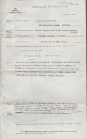
Document - H. A. & S. R. WILKINSON COLLECTION: CONTRACT OF SALE
... Property: lot 1 on plan of subdivision no. 19491 lodged in the office of titles being part of Crown allotment 24 Parish of Sandhurst County of Bendigo, land described in certificate of title volume 7646 folio 003 and situate Beischer Street, Bendigo, together with 5 roomed weatherboard dwelling, all sundry outbuildings, all floor coverings, blinds, curtains, Metro fridge, "Mettres" electric range, Hoover washing machine and all electric light fittings and shades. ...Property: lot 1 on plan of subdivision no. 19491 lodged in the office of titles being part of Crown allotment 24 Parish of Sandhurst County of Bendigo, land described in certificate of title volume 7646 folio 003 and situate Beischer Street, Bendigo, together with 5 roomed weatherboard dwelling, all sundry outbuildings, all floor coverings, blinds, curtains, Metro fridge, "Mettres" electric range, Hoover washing machine and all electric light fittings and shades. ...Contract of sale of land dated 25th August, 1956 between Mr. A. T. & Mrs. I. M. H. James (vendor) and Mr. J. H. Strange (purchaser). Property: lot 1 on plan of subdivision no. 19491 lodged in the office of titles being part of Crown allotment 24 Parish of Sandhurst County of Bendigo, land described in certificate of title volume 7646 folio 003 and situate Beischer Street, Bendigo, together with 5 roomed weatherboard dwelling, all sundry outbuildings, all floor coverings, blinds, curtains, Metro fridge, "Mettres" electric range, Hoover washing machine and all electric light fittings and shades. Price: 2,780 pounds. Attached 5 hand written notes .organization, business, h.a. & s.r wilkinson real estate -
 Eltham District Historical Society Inc
Film - Video (DVD), Frank Stokes, Stokes Family, 1950-1977
... lots were incorporated into five-acre parcels instead. With the arrival of the sewer along Diosma Road many years later, most of these five-acre parcels have since been subdivided many times. Representative of the orchard growing areas of Eltham beryl bradbury (nee stokes) collection frank stokes nyora road stokes orchard stokes orchard estate stokes place video recording MP4 00:24:39; 426MB Digital file only - Digitised by EDHS from a DVD copy on loan from Beryl Bradbury (nee Stokes), daughter of Frank Stokes. 24 min duration compilation of home movie Super 8mm film shot by Frank Stokes brother-in-law. ...Various family scenes taken from outside the family home on the southeast corner of the intersection of Nyora Road and Pitt Street with Eucalyptus Road. Also, scenes of the Stokes Orchard and equipment used, construction of water reservoir at the end of Nyora Road near Reynolds Road and Diosma Road as well as early stages of the Stokes Orchard housing development. Frank Stokes worked as a qualified accountant at Kennons leather factory in Burnley, while living at 1 Thomas Street, Mitcham. He suffered from migraines and wanted to go back to the land (he had previously worked on farms and orchards since coming to Australia in 1926 both in WA and Vic.). He first travelled to the district by train in July 1942 to find land with the intention to establish an orchard. By chance he met Arthur Bird of Bird Orchard (bounded by Pitt Street, Eucalyptus Road and Wattle Grove) and they got talking over their common interest. Arthur put Frank up for the night and pointed out the land, 158 acres- Taylor Estate- £900, part of Crown Allotment 15, Section 5, Parish of Nillumbik (CA15) somewhat diagonally opposite Bird Orchard. He applied through the Riverina Agency to purchase the land who in turn had to get permission from Canberra to sell as there was a new government regulation banning land sales except for immediate production. He obtained a loan on his Mitcham house of £600 @ 5% and paid £450 deposit with quarterly payments of £15 over 5 years. The title to the property was issued May 15, 1946. He was helped and advised by Arthur Bird who farmed the neighbouring orchard. Early 1943 he took possession and would catch the train out to Eltham on Fridays after work and began building a hut for shelter and to lock up tools. He was able to pay a neighbour (Hawkins) to help with clearing and fencing 25 acres and with a horse and single furrowed plow, planted approximately 2,500 fruit trees - cherries, peaches, plums, almonds, pears, apricots and lemons as well as a few apples and oranges; a massive job. A huge problem was hares and rabbits eating all the new buds off the tiny trees. As well as laying poison he painted the trees with a mixture of cow manure and lime. Often working by moonlight. It was extremely difficult to get wire and wire netting because of the war but after much effort he obtained a permit from the Agricultural Department for supplies in March 1944. In February 1945 he applied for a permit to build a “packing shed” as no house building allowed. It was to be 33 feet x 21 feet and cost £312. Constructed mostly from second-hand materials, which was hard to obtain, especially iron for roofing. Frank finished work at Kennons October 31, 1945, and in March 1946 he sold the Mitcham house for £1230 plus £170 for furniture. The family of five then moved into a very unfinished at Eltham, which was a struggle to weatherproof. Eventually rooms were divided off and lined with hessian bags and whitewashed. Their income was firewood (cut and sold), selling rockery stones and cut sweet bursaria. (It was discovered during the 1940s that Bursaria contained the sunscreen compound Aesculin. The RAAF utilised this compound from Bursaria during WW2 for pilots and gunners.) The orchard’s first fruit sale was a 1/2 case of Le Vanq peaches in December 1947 - 8 shillings. In 1956 plans for house were drawn and Glen Iris bricks purchased (1956 Olympic Rings variant). The building of the house commenced in 1957 - 12 feet of original packing shed removed – and was completed in 1959. Water was connected from newly built pressure storage on the property at the end of 1959 and the electricity connection for the first time at 3pm on April 29, 1960. In the mid-1970s the Shire of Eltham divided the orchard up into numerous rate-able parcel lots, which became unaffordable for Frank. Consequently, Stokes Orchard was turned into a housing development by Macquarie Builders and marketed as the Stokes Orchard Estate in two stages; Stage 1 encompassing Scarlet Ash Court, Ironbark Close and Peppermint Grove bounded by Nyora and Eucalyptus roads c.1976 and Stage 2 encompassing Stokes Place, Orchard Way, The Crest and The Lookout bound by Nyora and Diosma roads c.1979. The development of Orchard Way, The Crest and The Lookout did not proceed as planned due to the lack of the sewer along Diosma Road and so many of the proposed lots were incorporated into five-acre parcels instead. With the arrival of the sewer along Diosma Road many years later, most of these five-acre parcels have since been subdivided many times.Representative of the orchard growing areas of ElthamMP4 00:24:39; 426MB Digital file only - Digitised by EDHS from a DVD copy on loan from Beryl Bradbury (nee Stokes), daughter of Frank Stokes. 24 min duration compilation of home movie Super 8mm film shot by Frank Stokes brother-in-law.beryl bradbury (nee stokes) collection, frank stokes, nyora road, stokes orchard, stokes orchard estate, stokes place, video recording -
 Eltham District Historical Society Inc
Document - Folder, Greensborough Railway Station Estate, Lots 26, 26A and 26B, Crown Portion 3, Parish of Nillumbik, County of Evelyn (Rattray Road, Montmorency)
... Lots 26, 26A and 26B were part of the Greensborough Railway Station Estate. The land detailed is bounded by present-day Rattray Road, Reichelt Avenue, Wooded Way and Ryrie Court, Montmorency. Originally purchased in September 1913 by George William Miller, signwriter of Greensborough and Harry Frederick Miller, the land was sold to Mrs Margaret Barr Honeyman, 24 June 1918 on mortgage for £400, deposit paid £150. ...Lots 26, 26A and 26B were part of the Greensborough Railway Station Estate. The land detailed is bounded by present-day Rattray Road, Reichelt Avenue, Wooded Way and Ryrie Court, Montmorency. Originally purchased in September 1913 by George William Miller, signwriter of Greensborough and Harry Frederick Miller, the land was sold to Mrs Margaret Barr Honeyman, 24 June 1918 on mortgage for £400, deposit paid £150. ...Crown Portion 3 of Eltham, Parish of Nillumbik, County of Evelyn, Lots 26, 26A and 26B were part of the Greensborough Railway Station Estate. The land detailed is bounded by present-day Rattray Road, Reichelt Avenue, Wooded Way and Ryrie Court, Montmorency. Originally purchased in September 1913 by George William Miller, signwriter of Greensborough and Harry Frederick Miller, the land was sold to Mrs Margaret Barr Honeyman, 24 June 1918 on mortgage for £400, deposit paid £150. In February 1920, Mr Honeyman called for the title and paid off the loan early, settlement occuring 11 October 1920. Contents: 1. Handwritten payment plan (Sep 1913 to Mar 1923) for Lots 26, 26A and 26B being parts of Crown Portion 3, Parish of Nillumbik, County of Evelyn on the plan of subdivision making up the Greensborough Railway Station Estate situated on Rattray Road; purchased for £179.2.0 with a deposit of £18.0.0. 2. Receipt: From Messrs G.W. and H.F. Miller for £11.15.8 being instalment and interest, 9 Sep 1913 3. Invoice: To Messrs G.W. and H.F. Miller for £11.12.0 being instalment and interest due 15 Sep 1914 4. Contract of Sale: George William Miller and Harry Frederick Miller to Mrs. Margaret Barr Honeyman, in respect of sale of Lots 26, 26A and 26B for £400.0.0, 24 June 1918. Deposit of £150.0.0 balance to be paid half yearly instalments of £15 with interest at 5% per annum added. 5. Letter: Percy J. Russell, Solicitor to G.W. Miller, 5 Feb 1920 advising Mr Honeyman has called for the title and wishes to pay off mortgage. 6. Letter: Percy J. Russell, Solicitor to G.W. Miller, 11 Oct 1920 advising settlement and payment of Miller to Honeyman.contract of sale, george william miller, greensborough railway station estate, harry frederick miller, land sale, margaret barr honeyman, montmorency, rattray road, reichelt avenue, ryrie court, wooded way -
 Eltham District Historical Society Inc
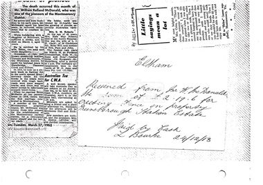
Document, Photocopy of receipts, etc
... McDonald the sum of of £2.19.6 for erecting fence on property Greensborough Station Estate, 24 December 1913 3. Little sayings mean a lot by Helen Orr McDonald...McDonald the sum of of £2.19.6 for erecting fence on property Greensborough Station Estate, 24 December 1913 3. Little sayings mean a lot by Helen Orr McDonald Early Settlers, Greensborough Railway Station Estate, Helen Orr McDonald, Montmorency, obituary, Receipt, W. ...1. Death of pioneer; Obituary, William Rolland McDonald, 27 March 1962 2. Receipt from Mr W. McDonald the sum of of £2.19.6 for erecting fence on property Greensborough Station Estate, 24 December 1913 3. Little sayings mean a lot by Helen Orr McDonaldDigital file only scanned by EDHS from item on loan (photocopy only)early settlers, greensborough railway station estate, helen orr mcdonald, montmorency, obituary, receipt, w. mcdonald, william rolland mcdonald -
 Bendigo Historical Society Inc.
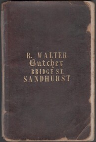
Book - 1859 Almanac
... At this time he sold five lots including, land at California Gully, 32 acres at Ellesmere, the Australia Hotel including a coopers, chemist and stables all leased to reliable tenants. In 1865 he was granted 50 square miles south of Charleville, near Murweh on the Warrego River. It was here that he died 24...At this time he sold five lots including, land at California Gully, 32 acres at Ellesmere, the Australia Hotel including a coopers, chemist and stables all leased to reliable tenants. In 1865 he was granted 50 square miles south of Charleville, near Murweh on the Warrego River. It was here that he died 24 ...Richard Walter, butcher, operated a butchery in Bridge St., Bendigo. The shop was part of the Australian Hotel. It was operating in 1857 when Walter advertised for a sausage maker. In 1863 the business was sold to Ceber and Robertson. At this time he sold five lots including, land at California Gully, 32 acres at Ellesmere, the Australia Hotel including a coopers, chemist and stables all leased to reliable tenants. In 1865 he was granted 50 square miles south of Charleville, near Murweh on the Warrego River. It was here that he died 24/8/1869 when he accidentally fell into the river and drowned.Small notebook (initial pages have been removed) with 1859 Almanac on internal covers. Ledger style notebook with gold lettering on cover "R. Walter, Butcher, Bridge Stret, Sandhurst"butcher, bridge stret, sandhurst", walter -
 Bendigo Historical Society Inc.
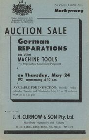
Document - IAN DYETT COLLECTION: AUCTION CATALOGUE - GERMAN REPARATIONS AND OTHER MACHINE TOOLS
... Three blue/grey auction catalogues for a sale, German Reparations and other Machine Tools (Not Required for Government Purposes) on 24 May, 1951 at Maribyrnong. Catalogue contain s descriptions of the lots. J. ...History House 11 Mackenzie Street Bendigo goldfields BUSINESS Auctioneers j h curnow & son pty ltd Ian Dyett Collection - Auction Catalogue - German Reparations and other Machine Tools J H Curnow & Son Pty Ltd Department of Supply The Academy Press Three blue/grey auction catalogues for a sale, German Reparations and other Machine Tools (Not Required for Government Purposes) on 24 May, 1951 at Maribyrnong. Catalogue contain s descriptions of the lots. J. ...Three blue/grey auction catalogues for a sale, German Reparations and other Machine Tools (Not Required for Government Purposes) on 24 May, 1951 at Maribyrnong. Catalogue contain s descriptions of the lots. J. H. Curnow & Son Pty Ltd were the auctioneers.business, auctioneers, j h curnow & son pty ltd, ian dyett collection - auction catalogue - german reparations and other machine tools, j h curnow & son pty ltd, department of supply, the academy press -
 Bendigo Historical Society Inc.
Document - LANDS OFFICE: SANDHURST CROWN LAND SOLD BY AUCTION 1854
... On front cover ' copy of sale books, town lots Sandhurst, April 18,19,20,21, 22 and 24 also suburban lots on the Bendigo Creek sold May 10TH.? ...On front cover ' copy of sale books, town lots Sandhurst, April 18,19,20,21, 22 and 24 also suburban lots on the Bendigo Creek sold May 10TH.? ...Document: LANDS OFFICE: SANDHURST CROWN LAND SOLD BY AUCTION 1854 booklet - brown paper cover with blue pages. On front cover ' copy of sale books, town lots Sandhurst, April 18,19,20,21, 22 and 24 also suburban lots on the Bendigo Creek sold May 10TH.? 1854' Booklet contains copies of advertisement for auctions, written alongside, name of purchaser and amount paid per acre. White sticker fixed to pocket ' Book 1, Sandhurst Land Sales, 10 May 1854 to 18 May 1854Lands Officelands office, bendigo, sandhurst, land sales -
 Bendigo Historical Society Inc.
Document - LANDS OFFICE, CROWN LOTS SURVEYED AND SOLD IN THE SANDHURST DISTRICT 1857 - 1905, 1857 - 1914
... Dated from 26/6/1857 to 24 February 1914 Document LANDS OFFICE, CROWN LOTS SURVEYED AND SOLD IN THE SANDHURST DISTRICT 1857 - 1905 ...Document: blue hard cover journal with buff spine and corners. (spine in poor condition, frayed and pieces missing) Contains details of crown lands surveyed and sold in Sandhurst district. LH page: town, suburban or country lands. RH page: auction, selection, price per acre, price overall and purchaser. Indexed by parish inside front cover. On spine ' Index book' ' Lands and Survey' '07' written on spine under damaged spine cover. Dated from 26/6/1857 to 24 February 1914Lands Officeland sales, lands office, land surveyed, land sold, bendigo, sandhurst -
 Ringwood and District Historical Society
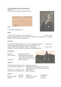
Document - Biography - Family Tree Extract, Alexander William Brown (1885-1957) - Nurseryman, Grandview Grove Ringwood (Warranwood) Vic
... Kardinia Crescent, Ringwood Land containing 2 acres 3 roods 24-1/2 perches situate in Kardinia Crescent Ringwood being Lots 33 and 34 on Plan of Subdivision Number 12040 and being part of Crown Section 20 Parish of Warrandyte County of Evelyn and being the land described in Certificate of Title Volume 7141 Folio 080 valued by E. ...Kardinia Crescent, Ringwood Land containing 2 acres 3 roods 24-1/2 perches situate in Kardinia Crescent Ringwood being Lots 33 and 34 on Plan of Subdivision Number 12040 and being part of Crown Section 20 Parish of Warrandyte County of Evelyn and being the land described in Certificate of Title Volume 7141 Folio 080 valued by E. ...A4 folder containing genealogical information, copy of will and copy of probate administration record including real estate assets for A.W. Brown, Grandview Grove Ringwood (Warranwood) Vic.EXTRACT: Inventory of Real Estate Assets (for Probate purposes) 1. Grandview Grove, Ringwood Land containing 10 acres or thereabouts situate in Grandview Grove Ringwood being part of Crown Section 20 Parish of Warrandyte County of Evelyn and being the land described in Certificate of Title Volume 5781 Folio 174 on which is erected a 7 room house, a bungalow, shed and 2 glass houses valued by E. Miles, Ringwood - £5077-0-0 2. Kardinia Crescent, Ringwood Land containing 2 acres 3 roods 24-1/2 perches situate in Kardinia Crescent Ringwood being Lots 33 and 34 on Plan of Subdivision Number 12040 and being part of Crown Section 20 Parish of Warrandyte County of Evelyn and being the land described in Certificate of Title Volume 7141 Folio 080 valued by E. Miles at £350-0-0