Showing 327 items matching "lower plenty - maps"
-
 Greensborough Historical Society
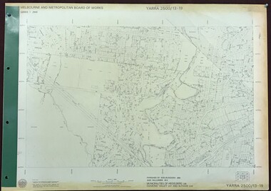
Map, Melbourne and Metropolitan Board of Works. Survey Division, MMBW, Yarra 2500 / 13.19. Lower Plenty, Montmorency, Yallambie, 1979_02
... ...lower plenty - maps...Yarra 2500 [base map] 13-19. Lower Plenty, Montmorency, Yallambie. Parishes of Keelbundora 2856 and Nillumbik 3310. ... yallambie - maps lower plenty - maps MMBW Map in 1:2500 [scale] series. ...Melbourne and Metropolitan Board of Works. Yarra 2500 [base map] 13-19. Lower Plenty, Montmorency, Yallambie. Parishes of Keelbundora 2856 and Nillumbik 3310. Municipalities of Heidelberg 228, Diamond Valley 257 and Eltham 238. Prominent streets include: Elder Street, Para Road, and Main Road Lower Plenty. Includes Watsonia Army Barracks.MMBW Map in 1:2500 [scale] series. Cream parchment with green tape reinforcing on edges and punched holes on left edge.mmbw, melbourne and metropolitan board of works, shire of diamond valley, montmorency - maps, yallambie - maps, lower plenty - maps -
 Eltham District Historical Society Inc
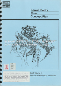
Book, Brett Cheatley et al, Lower Plenty River Concept Plan; Maroondah Pipetrack - Greensborough to Yarra/Plenty Confluence; Draft Volume B, Resource Description and Issues, February 1991
... Eltham District Historical Society Inc 728 Main Rd Eltham melbourne Concept Plan Melbourne Metropolitan Board of Works Plenty River Report Spiral bound A4, 33 pages inculding foldoiut A3 tables and maps (some coloured) 4 copies Lower Plenty River Concept Plan; Maroondah Pipetrack - Greensborough to Yarra/Plenty Confluence; Draft Volume B, Resource Description and Issues Book Book Brett Cheatley Ian Womersley Mal Warren Melbourne and Metropolitan Board of Works (Vic.). ...concept plan, melbourne metropolitan board of works, plenty river, report -
 Eltham District Historical Society Inc
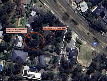
Document - Property Binder, 338 Main Road, Lower Plenty (also 37 Rangeview Road), March 2025
... ...Lower Plenty...Map...Goodison, Licensed Surveyor, and attached Surveyor's Report dated 6 June 1990 Notes: Items 1 to 6 donated electronically Items 7 to 9 sourced from LASSI - SPEAR, Department of Transport and Planning, Victoria State Government, https://maps.land.vic.gov.au/lassi/SpearUI.jsp Main Road Property Mudbrick David Newbury Phoebe Mason Collection Rate Books shire of eltham Certificate of Title Survey Plan 37 Rangeview Road 338 Main Road Application 23911 Lower Plenty Map Surveyor Field Notes Application 221805 Application 222467 Miscellaneous electrionic records, clippings, notes, photocopies, etc held on the subject property. 338 Main Road, Lower Plenty (also 37 Rangeview Road) Document Property Binder ...EDHS_03095-338 | EDHS_08635-37 338 Main Road Lower Plenty | 37 Rangeview Road, Lower Plenty Original Mudbrick cottage and studio designed and built by Eltham artist, David Alan Newbury See also EDHS_06090 David Newbury (Artist) David Newbury was married to Clare Margaret Newbury. According to the 1954 Electoral Roll they were living at 36A Murphy Street, South Yarra however around 1953 they purchased Lots 3 and 4 of Main Road Lot Plan LP 23911 in Lower Plenty. A building permit, No. 71, was issued 8 December 1953 for a 5-room house of Vertical Board construction, cost £2,840, builder L. Williams, owner D. Newbury of 36 Murphy Cl., South Yarra. The large house was in fact mostly built of mudbrick, the construction method was only just becoming recognised as an acceptable form in the late 1940s for issuance of a building permit. The house was commenced in 1954, designed by David Newbury and built by David Newbury, Horrie Judd and others. Information from Newbury family friends suggests that a second mudbrick building was constructed in the late 1950s, early 1960s for use as an artist studio by Newbury. The building was connected directly to the water mains at the time and was made suitable for living accommodation during the period Newbury was teaching at Bendigo. Apparently he and Claire rented out the main house during their time in Bendigo and would reside in the studio when visiting Melbourne. No permit for this studio was found in the Building Permit Register, Shire of Eltham, 1949-1960. The last recorded entries in the register are dated May 1960. This would suggest that the studio was constructed post May 1960. It is believed the studio was constructed during the latter period of Newbury’s teaching post in Bendigo so possibly late 1960/1961. In 1963 the Newbury’s address in the Electoral Roll has the property recorded as 220 Main Road, Lower Plenty. Between 1967 to 1980 the Electoral Rolls record the property as 338 Main Road. Today the address is 37 Rangeview Road, Lower Plenty. Contents: 1. Extract from 1942 Shire of Eltham Rate Book. Muriel Gladys Reitsma listed as owner 2. Extract from 1984-85 Shire of Eltham Rate Book for Rangeview Road. (No mention of No. 37 so was probably still listed as 338 Main Road.) 3. Certificate of Title, Vol. 5601 Fol. 1120089 - Issued to David James Graham of Lower Plenty, Builder, Heidelberg for Lot 32 Block B on Plan of Subdivision No. 7606, part of Crown Portion Two, Parish of Nillumbik, County of Evelyn, 29 October 1929 4. Certificate of Title, Vol. 8008 Fol. 076 - Issued to David Alan Newbury of 36 Murphy Street, South Yarra, School Teacher for Lot 3 on Plan of Subdivision No. 23911, part of Crown Portion Two, Parish of Nillumbik, County of Evelyn, 29 October 1953. Amended 24 June 1963 to transfer portion for road widening scheme per Country Roads Board Plan 6889 - Cancelled 24 September 1984 5. Certificate of Title, Vol. 9581 Fol. 583 - Issued to Paul Robert Biber and Althea Constance Biber of 139 Lower Heidelberg Road, Ivanhoe for Lot 3 on Plan of Subdivision No. 23911, part of Crown Portion Two, Parish of Nillumbik, County of Evelyn, 24 September 1984. Derived from Vol. 8008 Fol. 076 L276994V - Cancelled 20 Nov 1992 when subdivided from one to two lots in Vol 10092 Fol. 192 and Vol. 10092 Fol. 193; LP222467B 6. Certificate of Title, Vol. 10092 Fol. 192 - Transfer to Lawrie Mein of 20 Dewar Drive, Hurstbridge of Lot 1 on Plan of Subdivision No. 222467B, lodged 17 Feb 1993, Registered 29 March 1996. Parent Titles Vol 08008 Fol 077, Vol 09581 Fol 583 7. Survey Field Notes of Part of Crown Portion 2, Parish of Nillumbik, County of Evelyn - Portion of land bounded by New Eltham Road. Application 23911 dated 8 Sep 1952 with appended Surveyor Field notes per Application 7098; R.D. Steele, Licensed Surveyor, 18 August 1950 8. Survey Field Notes of Part of Crown Portion 2, Parish of Nillumbik, County of Evelyn - Portion of land bounded by Main Road and Rangeview Road; 2 Lot subdivisions, Vol. 9581 Fol. 583 Part Lot 3 on LP 23911 and Vol. 8008 Fol, 077 Lot 4 on LP 23911; Application 221805 dated 27 November 1989; W.J. Goodison, Licensed Surveyor, and attached Surveyor's Report dated 6 June 1990 (Withdrawn) 9. Survey Field Notes of Part of Crown Portion 2, Parish of Nillumbik, County of Evelyn - Portion of land bounded by Main Road and Rangeview Road; 2 Lot subdivisions, Vol. 9581 Fol. 583 Part Lot 3 on LP 23911 and Vol. 8008 Fol, 077 Lot 4 on LP 23911; Application 222467 dated 20 November 1992 (221805 resubmitted); W.J. Goodison, Licensed Surveyor, and attached Surveyor's Report dated 6 June 1990 Notes: Items 1 to 6 donated electronically Items 7 to 9 sourced from LASSI - SPEAR, Department of Transport and Planning, Victoria State Government, https://maps.land.vic.gov.au/lassi/SpearUI.jsp main road, property, mudbrick, david newbury, phoebe mason collection, rate books, shire of eltham, certificate of title, survey plan, 37 rangeview road, 338 main road, application 23911, lower plenty, map, surveyor field notes, application 221805, application 222467 -
 Greensborough Historical Society
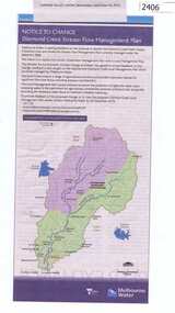
Newspaper Clipping, Diamond Creek stream flow management plan, 30/09/2015
... Greensborough Historical Society 34A Glenauburn Road Lower Plenty Lower Plenty melbourne In this Public Notice, Melbourne Water seeks feedback on the Diamond Creek Stream Flow Management Plan. diamond creek stream flow management plan melbourne water. News clipping, black text, colour map ...In this Public Notice, Melbourne Water seeks feedback on the Diamond Creek Stream Flow Management Plan.News clipping, black text, colour map.diamond creek stream flow management plan, melbourne water. -
 Greensborough Historical Society
Book, Angus & Robertson Ltd, The Australian Encyclopaedia, 1958_
... Greensborough Historical Society 34A Glenauburn Road Lower Plenty Lower Plenty melbourne Standard history of Australia to 1958 australian encyclopaedia 10 vols. illus. maps with index vol. 10 The Australian Encyclopaedia Book Angus & Robertson Ltd ...Standard history of Australia to 195810 vols. illus. maps with index vol. 10australian encyclopaedia -
 Greensborough Historical Society
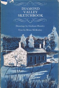
Book, Diamond Valley Sketchbook, 1973_
... Greensborough Historical Society 34A Glenauburn Road Lower Plenty Lower Plenty melbourne Contains drawings by Graham Hawley and text by Brian McKinley. Shows landmarks around the Diamond Valley. diamond valley eltham greensborough "Happy birthday Kathryn May 1976" 63p., illus., map as endpapers, dustcover. ...Contains drawings by Graham Hawley and text by Brian McKinley. Shows landmarks around the Diamond Valley.63p., illus., map as endpapers, dustcover."Happy birthday Kathryn May 1976"diamond valley, eltham, greensborough -
 Greensborough Historical Society
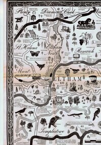
Map, George W. Bell, Eltham Warrandyte and environs: a visitor's guide map: centenary souvenir. 2nd ed, 1994c
... Greensborough Historical Society 34A Glenauburn Road Lower Plenty Lower Plenty melbourne Tourist guide to historic and other features in the Eltham Warrandyte area and environs, warrandyte eltham st helena montmorency A2, black & white, folded 3 times to A5, printed on one side Eltham Warrandyte and environs: a visitor's guide map: centenary souvenir. 2nd ed. ...Tourist guide to historic and other features in the Eltham Warrandyte area and environs, A2, black & white, folded 3 times to A5, printed on one sidewarrandyte, eltham, st helena, montmorency -
 Greensborough Historical Society
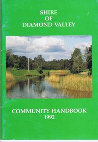
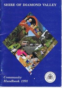
Book, Shire of Diamond Valley, Shire of Diamond Valley Community Handbook 1992, 1992_
... Lower Plenty Lower Plenty melbourne Guide to services provided by Shire of Diamond Valley. The Shire of Diamond Valley was a Local Government Area located about 20 kilometres northeast of Melbourne. The shire covered an area of 74.38 square kilometres and existed from 1964 until 1994. Annual guide to services in Shire of Diamond Valley shire of diamond valley 52 pages, col illus., maps ...Guide to services provided by Shire of Diamond Valley. The Shire of Diamond Valley was a Local Government Area located about 20 kilometres northeast of Melbourne. The shire covered an area of 74.38 square kilometres and existed from 1964 until 1994.Annual guide to services in Shire of Diamond Valley52 pages, col illus., maps. Cover illustration of Kalparrin Gardens Greensboroughshire of diamond valley -
 Greensborough Historical Society
Book, Shire of Diamond Valley, Shire of Diamond Valley Community Handbook 1991, 1991_
... Lower Plenty Lower Plenty melbourne Guide to services provided by Shire of Diamond Valley. The Shire of Diamond Valley was a Local Government Area located about 20 kilometres northeast of Melbourne. The shire covered an area of 74.38 square kilometres and existed from 1964 until 1994. Annual guide to services in Shire of Diamond Valley shire of diamond valley 36 pages, col. illus., maps ...Guide to services provided by Shire of Diamond Valley. The Shire of Diamond Valley was a Local Government Area located about 20 kilometres northeast of Melbourne. The shire covered an area of 74.38 square kilometres and existed from 1964 until 1994.Annual guide to services in Shire of Diamond Valley36 pages, col. illus., maps. Front cover is a collage of scenes from Diamond Valley, back cover illustration of a copy of "Summer Panorama, Tabletop, NSW" by Max Dimmack, from the Shire of Diamond Valley Art Collection.shire of diamond valley -
 Greensborough Historical Society
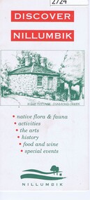
Leaflet, Nillumbik Shire Council, Discover Nillumbik, 2000c
... Greensborough Historical Society 34A Glenauburn Road Lower Plenty Lower Plenty melbourne Map and lists of attractions within the Shire of Nillumbik nillumbik Double sided, folded seven times printed in red and green Discover Nillumbik Leaflet Nillumbik Shire Council ...Map and lists of attractions within the Shire of NillumbikDouble sided, folded seven times printed in red and greennillumbik -
 Greensborough Historical Society
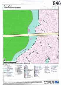
Map, Plenty River Children's Cemetery - location map, 1848-1860
... Lower Plenty Lower Plenty melbourne The unmarked graves of the children of two Greensborough pioneer families lie in a private cemetery on the Plenty River. Burials occurred between 1848 and 1860. The significance lies in the association with two of the pioneer families of the Greensborough district. Descendants of both families still live in the area. One page map ...The unmarked graves of the children of two Greensborough pioneer families lie in a private cemetery on the Plenty River. Burials occurred between 1848 and 1860.The significance lies in the association with two of the pioneer families of the Greensborough district. Descendants of both families still live in the area.One page map accompanies article item #804 -
 Greensborough Historical Society
Map, Scotprint, A Guide to World War II 'Invasion or Liberation': Western Europe Sept 1939 to March 1945, 1999_
... Greensborough Historical Society 34A Glenauburn Road Lower Plenty Lower Plenty melbourne Notes of battles, military leaders, cemeteries and other features of World War 11 Western Europe. world war ii Double sided col. maps, with notes of battles, military leaders, cemeteries and other features of World War 11 Western Europe. ...Notes of battles, military leaders, cemeteries and other features of World War 11 Western Europe.Double sided col. maps, with notes of battles, military leaders, cemeteries and other features of World War 11 Western Europe.world war ii -
 Greensborough Historical Society
Map, Map of Greensborough - Jessop's Real Estate, 1930c
... Greensborough Historical Society 34A Glenauburn Road Lower Plenty Lower Plenty melbourne This map of Greensborough hung in the office of Cec Jessop's Real Estate office corner Main and Grimshaw Street. ...This map of Greensborough hung in the office of Cec Jessop's Real Estate office corner Main and Grimshaw Street. Includes a word document listing street name changes from the original map to today, according to Norm Colvin.This map was saved from the building when the business closed.Canvas roll-up map with timber rails top and bottom.greensborough - maps, cecil jessop, greensborough street names -
 Greensborough Historical Society
Folder, Shire of Diamond Valley, Shire of Diamond Valley forms, 1980-1994
... Greensborough Historical Society 34A Glenauburn Road Lower Plenty Lower Plenty melbourne Forms, staff telephone lists, organisation charts, maps, administrative memos, directives and bulletins used by the Shire of Diamond Valley 1980s -1994. shire of diamond valley Arch file containing forms etc. used by the Shire of Diamond Valley Shire of Diamond Valley forms Folder Shire of Diamond Valley ...Forms, staff telephone lists, organisation charts, maps, administrative memos, directives and bulletins used by the Shire of Diamond Valley 1980s -1994.Arch file containing forms etc. used by the Shire of Diamond Valleyshire of diamond valley -
![Planning Document, Plan of proposed subdivision of land in Greensborough [Map shows Scotland house], 01/04/1971](/media/collectors/4f729f5697f83e03086015b8/items/5982a68921ea6b1420e4e560/item-media/59916fb521ea681094908d7a/item-fit-380x285.jpg?cb=6) Greensborough Historical Society
Greensborough Historical SocietyPlanning Document, Plan of proposed subdivision of land in Greensborough [Map shows Scotland house], 01/04/1971
... Greensborough Historical Society 34A Glenauburn Road Lower Plenty Lower Plenty melbourne This subdivision of Greensborough shows the home of John Scotland (died 1888) and surrounding area bounded by Hailes, William, Lorimer, and Jessop Streets. john scotland hailes street greensborough william street greensborough lorimer street greensborough jessop street greensborough Part of plan (68G) of proposed subdivision of Greensborough, part of Crown Portion 18, Parish pf Keelbundora. Scale: 132 ft. to an inch Photocopy of plan, 2 pages. Plan of proposed subdivision of land in Greensborough [Map ...This subdivision of Greensborough shows the home of John Scotland (died 1888) and surrounding area bounded by Hailes, William, Lorimer, and Jessop Streets.Photocopy of plan, 2 pages.Part of plan (68G) of proposed subdivision of Greensborough, part of Crown Portion 18, Parish pf Keelbundora. Scale: 132 ft. to an inchjohn scotland, hailes street greensborough, william street greensborough, lorimer street greensborough, jessop street greensborough -
 Greensborough Historical Society
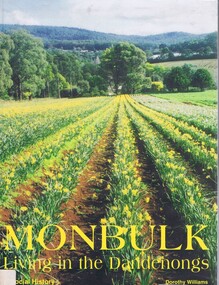
Book, Dorothy Williams, Monbulk: living in the Dandenongs, a social history, by Dorothy Williams, 1998_
... Greensborough Historical Society 34A Glenauburn Road Lower Plenty Lower Plenty melbourne History of Monbulk from early settlement in 1837 to 1997. monbulk mount dandenong Paperback, 325 p., black and white photographs, maps. ...History of Monbulk from early settlement in 1837 to 1997.Paperback, 325 p., black and white photographs, maps.monbulk, mount dandenong -
 Greensborough Historical Society
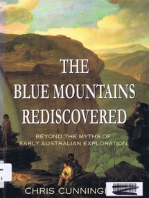
Book, Chris Cunningham, The Blue Mountains rediscovered: beyond the myths of early Australian exploration, by Chris Cunningham, 1996_
... Greensborough Historical Society 34A Glenauburn Road Lower Plenty Lower Plenty melbourne Written from both an historical and geographical view, this book tells the story of early inland exploration across the Blue Mountains. blue mountains nsw Paperback, 192 p., col. photographs, black and white maps. ...Written from both an historical and geographical view, this book tells the story of early inland exploration across the Blue Mountains.Paperback, 192 p., col. photographs, black and white maps.blue mountains nsw -
 Greensborough Historical Society
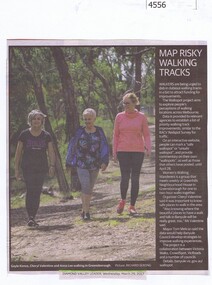
Newspaper Clipping, Diamond Valley Leader, Map risky walking tracks, 29/03/2017
... Greensborough Historical Society 34A Glenauburn Road Lower Plenty Lower Plenty melbourne Walkers are being urged to dob in dubious walking tracks in a bid to attract funding for improvements. walking tracks walkspot project womens walking wanderers News article 1 page, black text, colour image. Map ...Walkers are being urged to dob in dubious walking tracks in a bid to attract funding for improvements.News article 1 page, black text, colour image.walking tracks, walkspot project, womens walking wanderers -
 Greensborough Historical Society
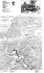
Map, Dennis Ward, John Batman's 1835 Treaty Trail on the Plenty River, 2010_
... Greensborough Historical Society 34A Glenauburn Road Lower Plenty Lower Plenty melbourne Map of the Plenty River through Greensborough and surrounding areas, annotated with historic places. ...Map of the Plenty River through Greensborough and surrounding areas, annotated with historic places. Prepared by Dennis Ward, this map shows places of interest with historic markers for a proposed Heritage Trail along the Plenty. This was a joint project of Dennis Ward, Rotary Greensborough and Nillumbik Historical Society.This map shows many places of interest along the Plenty River. Large laminated map, including land subdivisions and street names.plenty river heritage trail -
 Greensborough Historical Society
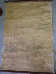
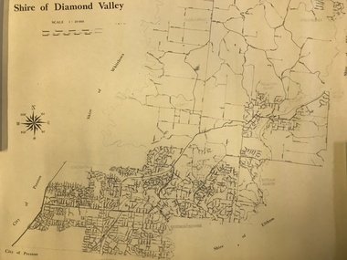
Map, Shire of Diamond Valley, 1964-1994
... Greensborough Historical Society 34A Glenauburn Road Lower Plenty Lower Plenty melbourne Map of the former Shire of Diamond Valley, 1964-1994, showing the local government area from Greensborough to Hurstbridge. shire of diamond valley greensborough hurstbridge Map on yellowed paper. ...Map of the former Shire of Diamond Valley, 1964-1994, showing the local government area from Greensborough to Hurstbridge.Map on yellowed paper.shire of diamond valley, greensborough, hurstbridge -
 Greensborough Historical Society
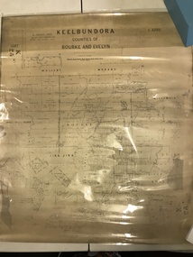
Map, Victoria. Department of Crown Lands and Survey, Keelbundoora; Counties of Bourke and Evelyn, 1950c
... Greensborough Historical Society 34A Glenauburn Road Lower Plenty Lower Plenty melbourne Map of the Victorian counties of Bourke and Evelyn showing parish boundaries and land ownership. ...Map of the Victorian counties of Bourke and Evelyn showing parish boundaries and land ownership.Show the original landholders for this area.Map on light brown parchment, covered in plastic."L.5305" and "3462" -
 Greensborough Historical Society
Map, Green's subdivision of Greensborough, 1860c
... Greensborough Historical Society 34A Glenauburn Road Lower Plenty Lower Plenty melbourne This map shows the original subdivision of Greensborough by Edward Bernard Green. ...This map shows the original subdivision of Greensborough by Edward Bernard Green. Some street names are different to today. This map shows the plan on which the town of Greensborough was based.Copy of early map showing subdivision of Greensborough. Black ink on white paper.edward bernard green, greensborough -
 Greensborough Historical Society
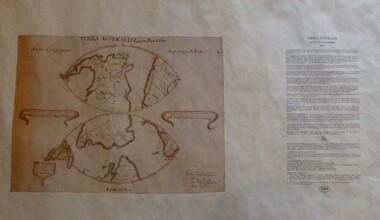
Map, Mapping Authority of NSW, Terra Australis: Quinta Pars Orbis, 1676_
... Greensborough Historical Society 34A Glenauburn Road Lower Plenty Lower Plenty melbourne The original of this map was drawn by an Italian priest Father Victorio Riccio in 1676 from knowledge brought to Manila on Dutch ships. ...The original of this map was drawn by an Italian priest Father Victorio Riccio in 1676 from knowledge brought to Manila on Dutch ships. Father Riccio was suggesting a Catholic mission to Terra Australia.Reproduction of an early map of Australia, pre-dating the voyages of Captain Cook.Facsimile map in cardboard protective tubeterra australis -
 Greensborough Historical Society
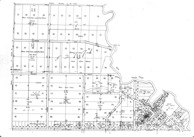
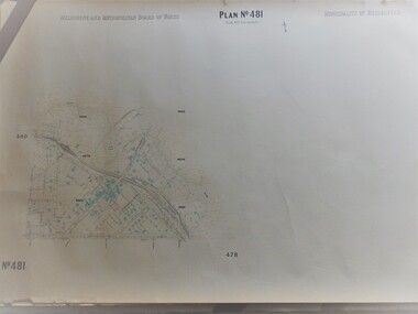
Map, Melbourne & Metropolitan Board of Works, MMBW Plan No.481, 23/09/1949
... Greensborough Historical Society 34A Glenauburn Road Lower Plenty Lower Plenty melbourne MMBW plan of part of central Greensborough, Main Street and surrounds, from sports ovals in North to Grimshaw Street in South. Map ...MMBW plan of part of central Greensborough, Main Street and surrounds, from sports ovals in North to Grimshaw Street in South.Map shows buildings and topography for the area.MMBW plan, black and colour ink on beige parchment, 2 copies."Scale:160 feet to 1 inch"melbourne and metropolitan board of works, mmbw, greensborough -
 Greensborough Historical Society
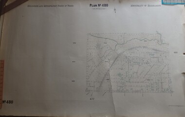
Map, Melbourne & Metropolitan Board of Works, MMBW Plan No.480, 17/10/1949
... Greensborough Historical Society 34A Glenauburn Road Lower Plenty Lower Plenty melbourne MMBW plan of part of central Greensborough, from Plenty River in North to Grimshaw Street in South, Sellars Street in West to Kerr Street in East. Map ...MMBW plan of part of central Greensborough, from Plenty River in North to Grimshaw Street in South, Sellars Street in West to Kerr Street in East.Map shows buildings and topography for the area.MMBW plan, black and colour ink on beige parchment, 4 copies."Scale:160 feet to 1 inch"melbourne and metropolitan board of works, mmbw, greensborough -
 Greensborough Historical Society
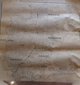
Map, City of Heidelberg. Engineers Dept, City of Heidelberg, 1960s
... Greensborough Historical Society 34A Glenauburn Road Lower Plenty Lower Plenty melbourne Map of the City of Heidelberg from the Yarra River in the South to North of Watsonia Military Camp. ...Map of the City of Heidelberg from the Yarra River in the South to North of Watsonia Military Camp. Shire of Diamond Valley is shown to the north.Map showing municipal and ward boundaries, black text on light brown paper."Scale: 20 CHS = to 1 IN"city of heidelberg -
 Greensborough Historical Society
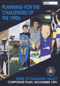
Pamphlet, Planning for the challenges of the 1990s: Shire of Diamond Valley Corporate Plan, 1991_11
... Greensborough Historical Society 34A Glenauburn Road Lower Plenty Lower Plenty melbourne Shire of Diamond Valley Corporate Plan 1991. Includes Shire map and statistics with plans for services to the community. shire of diamond valley 16p. text and coloured photographs Planning for the challenges of the 1990s: Shire of Diamond Valley Corporate Plan Pamphlet Shire of Diamond Valley ...Shire of Diamond Valley Corporate Plan 1991. Includes Shire map and statistics with plans for services to the community.16p. text and coloured photographsshire of diamond valley -
 Greensborough Historical Society
Article, Dawn Bennetts (nee Petts), Eltham Community Market, 1978o
... Greensborough Historical Society 34A Glenauburn Road Lower Plenty Lower Plenty melbourne A history of the Eltham Community Market by stallholder Dawn Bennetts. The Market began in 1978 and Dawn joined in 1985. eltham community market dawn bennetts 7 typed pages, col. illus. and maps. ...A history of the Eltham Community Market by stallholder Dawn Bennetts. The Market began in 1978 and Dawn joined in 1985.7 typed pages, col. illus. and maps.eltham community market, dawn bennetts -
 Greensborough Historical Society
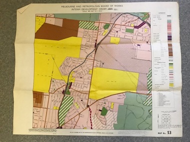
Map, Melbourne and Metropolitan Board of Works Interim Development Order 1961 Map No. 53, 27/09/1961
... Lower Plenty Lower Plenty melbourne Denotes Zones and Reservations comprising part of the municipalities of Eltham, Heidelberg, Preston and Whittlesea, approved 27.9.61. Includes Mont Park Hospital and Watsonia Military Camp. greensborough watsonia Date printed on plan (1959) has been over stamped with 1961. Also stamped with Government Gazette date of 27.9.1961. "Scale 800 feet to 1 inch" Colour plan Melbourne and Metropolitan Board of Works Interim Development Order 1961 Map ...Denotes Zones and Reservations comprising part of the municipalities of Eltham, Heidelberg, Preston and Whittlesea, approved 27.9.61. Includes Mont Park Hospital and Watsonia Military Camp.Colour plan Date printed on plan (1959) has been over stamped with 1961. Also stamped with Government Gazette date of 27.9.1961. "Scale 800 feet to 1 inch"greensborough, watsonia -
 Greensborough Historical Society
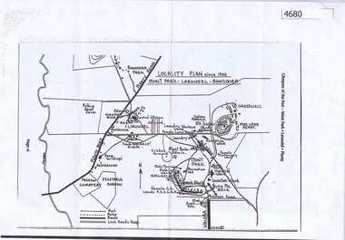
Map, Mont Park buildings still existing, 1946_
... Greensborough Historical Society 34A Glenauburn Road Lower Plenty Lower Plenty melbourne Locality Plan indicates buildings still existing within the Mont Park - Larundel mental health complex; Table lists 16 buildings by year built, initial purpose, subsequent uses and current address larundel mont park 2 pages,one map, one table Mont Park buildings still existing Map ...Locality Plan indicates buildings still existing within the Mont Park - Larundel mental health complex; Table lists 16 buildings by year built, initial purpose, subsequent uses and current address2 pages,one map, one table larundel, mont park