Showing 11103 items matching "lower plenty road"
-
 Eltham District Historical Society Inc
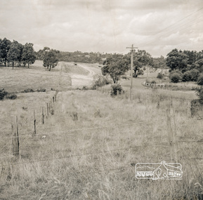
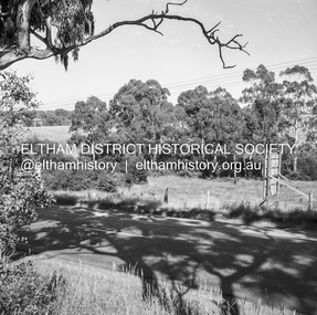
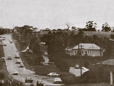
Photograph, Looking east from the northern side of Lower Plenty Road (opposite Bannockburn Road) as it crosses the Watsonia Drain, Viewbank, c.1965, 1965c
... Looking east from the northern side of Lower Plenty Road (opposite Bannockburn Road) as it crosses the Watsonia Drain, Viewbank, c.1965...Lower Plenty...Lower Plenty Hotel...Road...Transmission power lines visible in distance behind the Lower Plenty Hotel (in centre upper) and parts of Heidelberg Golf Club. In the foreground a bulldozer can be seen commencing roadworks for the re-alignment of Lower Plenty Road for the new Lower Plenty Bridge crossing....Heidelberg Golf Club Lower Plenty Lower Plenty Hotel Road construction Viewbank Watsonia Drain Medium format 120 6x6 black and white negative film, 1 frame Looking east from the northern side of Lower Plenty Road (opposite Bannockburn Road) as it crosses the Watsonia Drain, Viewbank, c.1965 Photograph ...Transmission power lines visible in distance behind the Lower Plenty Hotel (in centre upper) and parts of Heidelberg Golf Club. In the foreground a bulldozer can be seen commencing roadworks for the re-alignment of Lower Plenty Road for the new Lower Plenty Bridge crossing.Medium format 120 6x6 black and white negative film, 1 frameheidelberg golf club, lower plenty, lower plenty hotel, road construction, viewbank, watsonia drain -
 Eltham District Historical Society Inc
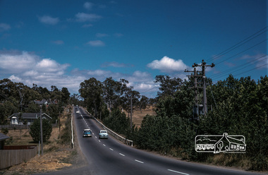
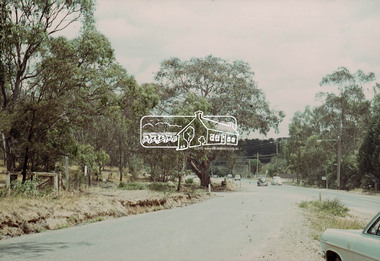
Photograph, Fred Mitchell, Lower Plenty Road, Yallambie, 1968, 1968
... Lower Plenty Road, Yallambie, 1968......Lower Plenty Road...Immediately to left is Broadlea Crescent. fred mitchell collection 1968 Broadlea crescent Lower Plenty Road Watsonia Barracks yallambie Digital copy of colour photograph Lower Plenty Road, Yallambie, 1968 Photograph Fred Mitchell ...Road to Rosanna beside Watsonia Army Barracks. Immediately to left is Broadlea Crescent.Digital copy of colour photographfred mitchell collection, 1968, broadlea crescent, lower plenty road, watsonia barracks, yallambie -
 Greensborough Historical Society
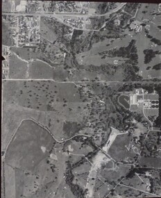
Aerial Photograph, Banyule Road / Lower Plenty Road, 1972c
... Banyule Road / Lower Plenty Road...Viewbank, Rosanna and Lower Plenty area, showing Lower Plenty Road and Banyule Road...Greensborough Historical Society 34A Glenauburn Road Lower Plenty Lower Plenty melbourne Viewbank, Rosanna and Lower Plenty area, showing Lower Plenty Road and Banyule Road viewbank Aerial survey photograph, black and white Banyule Road / Lower Plenty Road Aerial Photograph ...Viewbank, Rosanna and Lower Plenty area, showing Lower Plenty Road and Banyule RoadAerial survey photograph, black and whiteviewbank -
 Eltham District Historical Society Inc
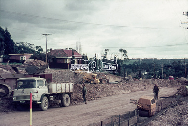
Slide, Looking southwest across to 184 Main Road, Lower Plenty during road widening works, 20 July 1970, 1970
... Looking southwest across to 184 Main Road, Lower Plenty during road widening works, 20 July 1970...duplication, Lower Plenty, Main Road, Road construction...Road works to widen and duplicate Main Road at Lower Plenty from top of hill near Grand Boulevard, Montmorency to shire border at Lower Plenty bridge...Eltham District Historical Society Inc 728 Main Rd Eltham melbourne Road works to widen and duplicate Main Road at Lower Plenty from top of hill near Grand Boulevard, Montmorency to shire border at Lower Plenty bridge duplication, Lower Plenty, Main Road, Road construction 35 mm colour positive transparency Mount - Agfacolor Service (Blue) Looking southwest across to 184 Main Road, Lower Plenty during road widening works, 20 July 1970 Slide ...Road works to widen and duplicate Main Road at Lower Plenty from top of hill near Grand Boulevard, Montmorency to shire border at Lower Plenty bridge35 mm colour positive transparency Mount - Agfacolor Service (Blue)duplication, lower plenty, main road, road construction -
 Eltham District Historical Society Inc
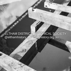
Negative - Photograph, J.A. McDonald, Eltham-Yarra Glen Road, Lower Plenty footbridge, Sep. 1955
... Eltham-Yarra Glen Road, Lower Plenty footbridge...Lower Plenty...Lower Plenty Bridge...Lower Plenty Road...Road as designated originated at the Shire of Eltham boundary at the Plenty River. West of the river the road was known as the Heidelberg-Eltham Road. The section from the Plenty River is now known as Lower...Road as designated originated at the Shire of Eltham boundary at the Plenty River. West of the river the road was known as the Heidelberg-Eltham Road. The section from the Plenty River is now known as Lower ...The Eltham-Yarra Glen Road as designated originated at the Shire of Eltham boundary at the Plenty River. West of the river the road was known as the Heidelberg-Eltham Road. The section from the Plenty River is now known as Lower Plenty Road which becomes Main Road. The footbridge no longer exists but was originally sited to the south, adjacent to the old Lower Plenty Bridge, now part of the Plenty River Trail. Record of various Shire of Eltham infrastructure works undertaken during the period of 1952-1962 involving bridge and road reconstruction projects, sometimes with Eltham Shire Council Project Reference numbers quoted. It was during this period that a number of significant improvements were made to roads and new bridges constructed within the shire that remain in place as of present day (2022). In many situations, the photos provide a tangible visible record of infrastructure that existed throughout the early days of the Shire. The album was put together by or under the direction of the Shire Engineer, J.A. McDonald.1955-09, eltham-yarra glen road, lower plenty footbridge, lower plenty, lower plenty bridge, lower plenty road, main road, plenty river trail, bridge construction, infrastructure, shire of eltham -
 Eltham District Historical Society Inc
Negative - Photograph, J.A. McDonald, Eltham-Yarra Glen Road, Lower Plenty footbridge, Sep. 1955
... Eltham-Yarra Glen Road, Lower Plenty footbridge...Lower Plenty...Lower Plenty Bridge...Lower Plenty Road...Road as designated originated at the Shire of Eltham boundary at the Plenty River. West of the river the road was known as the Heidelberg-Eltham Road. The section from the Plenty River is now known as Lower...Road as designated originated at the Shire of Eltham boundary at the Plenty River. West of the river the road was known as the Heidelberg-Eltham Road. The section from the Plenty River is now known as Lower ...Tony Carberry and J. Jolly The Eltham-Yarra Glen Road as designated originated at the Shire of Eltham boundary at the Plenty River. West of the river the road was known as the Heidelberg-Eltham Road. The section from the Plenty River is now known as Lower Plenty Road which becomes Main Road. The footbridge no longer exists but was originally sited to the south, adjacent to the old Lower Plenty Bridge, now part of the Plenty River Trail. Record of various Shire of Eltham infrastructure works undertaken during the period of 1952-1962 involving bridge and road reconstruction projects, sometimes with Eltham Shire Council Project Reference numbers quoted. It was during this period that a number of significant improvements were made to roads and new bridges constructed within the shire that remain in place as of present day (2022). In many situations, the photos provide a tangible visible record of infrastructure that existed throughout the early days of the Shire. The album was put together by or under the direction of the Shire Engineer, J.A. McDonald.1955-09, eltham-yarra glen road, lower plenty footbridge, j. jolly, lower plenty, lower plenty bridge, lower plenty road, main road, plenty river trail, tony carberry, bridge construction, infrastructure, shire of eltham -
 Eltham District Historical Society Inc
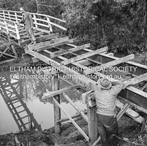
Negative - Photograph, J.A. McDonald, Eltham-Yarra Glen Road, Lower Plenty, c. July 1962
... Eltham-Yarra Glen Road, Lower Plenty......Lower Plenty...Road...Present-day Lower Plenty Road follows a revised alignment across a new bridge. ...Present-day Lower Plenty Road follows a revised alignment across a new bridge. ...View looking west across the Eltham-Yarra Glen Road approaching the Lower Plenty Bridge near turn-off for the Golf Club Hotel. Present-day Lower Plenty Road follows a revised alignment across a new bridge. The former bridge is now part of the Plenty River Trail and Edward Willis Court now follows this section of the original Eltham-Yarra Glen Road.. The Golf Club Hotel is gone and a new Lower Plenty Hotel was built slightly further up the hill.Record of various Shire of Eltham infrastructure works undertaken during the period of 1952-1962 involving bridge and road reconstruction projects, sometimes with Eltham Shire Council Project Reference numbers quoted. It was during this period that a number of significant improvements were made to roads and new bridges constructed within the shire that remain in place as of present day (2022). In many situations, the photos provide a tangible visible record of infrastructure that existed throughout the early days of the Shire. The album was put together by or under the direction of the Shire Engineer, J.A. McDonald.1962-07, shire of eltham, old eltham road, edward willis court, eltham-yarra glen road, golf club hotel, infrastructure, lower plenty, road construction -
 Eltham District Historical Society Inc
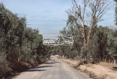
Photograph, Main Road, Lower Plenty
... Main Road, Lower Plenty...lower plenty...main road...Black and white photograph of Main Road, Lower Plenty looking west from Old Eltham Road...Date of photo is pre 1960s before duplication of Main Road. lower plenty main road old eltham road Black and white photograph of Main Road, Lower Plenty looking west from Old Eltham Road Main Road, Lower Plenty Photograph ...View is from Old Eltham Road looking northwest across Main Road to the De Bondy property and family home. Date of photo is pre 1960s before duplication of Main Road.Black and white photograph of Main Road, Lower Plenty looking west from Old Eltham Roadlower plenty, main road, old eltham road -
 Eltham District Historical Society Inc
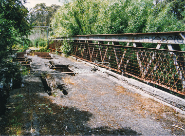
Photograph, Doug Orford, Lower Plenty Bridge, Old Eltham Road, Lower Plenty, 1998
... Lower Plenty Bridge, Old Eltham Road, Lower Plenty......lower plenty...main road...The bridge has since been restored and is now part of the Plenty River Trail. bridges lower plenty main road plenty river Old Eltham Road Two colour photograph prints 10 x 15 cm (2 copies) Lower Plenty Bridge, Old Eltham Road, Lower Plenty Photograph Photograph Doug Orford ...Originally the boundary between the former Shire of Eltham and the City of Heidelberg, a toll gate existed on the Eltham side. The bridge has since been restored and is now part of the Plenty River Trail.Two colour photograph prints 10 x 15 cm (2 copies)bridges, lower plenty, main road, plenty river, old eltham road -
 Greensborough Historical Society
Photograph - Photograph (Copy), Anne Paul, Lot 2A Main Road Lower Plenty, 2007_05
... Lot 2A Main Road Lower Plenty...lower plenty...main road...Three views of entry into Lot 2A Main Road Lower Plenty, now Edward Willis Drive....Greensborough Historical Society 34A Glenauburn Road Lower Plenty Lower Plenty melbourne Three views of entry into Lot 2A Main Road Lower Plenty, now Edward Willis Drive. lower plenty main road lower plenty edward willis drive lower plenty 3 colour photographs printed on paper, handwritten captions Lot 2A Main Road Lower Plenty Photograph Photograph (Copy) Anne Paul ...Three views of entry into Lot 2A Main Road Lower Plenty, now Edward Willis Drive.3 colour photographs printed on paper, handwritten captionslower plenty, main road lower plenty, edward willis drive lower plenty -
 Eltham District Historical Society Inc
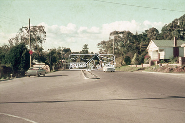
Photograph, Looking northeast along Main Road at intersection with Para Road, Lower Plenty, July 1969, 1969
... Looking northeast along Main Road at intersection with Para Road, Lower Plenty, July 1969...Lower plenty, main road, para road...House on right is 122 Main Road, Lower Plenty viewed from intersection of Main Road with Para Road...Eltham District Historical Society Inc 728 Main Rd Eltham melbourne House on right is 122 Main Road, Lower Plenty viewed from intersection of Main Road with Para Road Lower plenty, main road, para road 35mm colour positive transparency blue Agfacolour Service plastic mount Looking northeast along Main Road at intersection with Para Road, Lower Plenty, July 1969 Photograph ...House on right is 122 Main Road, Lower Plenty viewed from intersection of Main Road with Para Road35mm colour positive transparency blue Agfacolour Service plastic mountlower plenty, main road, para road -
 Eltham District Historical Society Inc
Negative - Photograph, J.A. McDonald, Eltham-Yarra Glen Road, Lower Plenty, c. July 1962
... Eltham-Yarra Glen Road, Lower Plenty......Lower Plenty Road...McDonald. 1962-07 Eltham-Yarra Glen Road Infrastructure Lower Plenty Lower Plenty Road Road construction shire of eltham Old Eltham Road Medium format 120/Kodak 620 6x6 cm black and white negative (1 of 12) contained in a Filmpro processing envelope with various inscriptions and markings. ...View looking west across Old Eltham Road to the Eltham-Yarra Glen RoadRecord of various Shire of Eltham infrastructure works undertaken during the period of 1952-1962 involving bridge and road reconstruction projects, sometimes with Eltham Shire Council Project Reference numbers quoted. It was during this period that a number of significant improvements were made to roads and new bridges constructed within the shire that remain in place as of present day (2022). In many situations, the photos provide a tangible visible record of infrastructure that existed throughout the early days of the Shire. The album was put together by or under the direction of the Shire Engineer, J.A. McDonald.1962-07, eltham-yarra glen road, infrastructure, lower plenty, lower plenty road, road construction, shire of eltham, old eltham road -
 Greensborough Historical Society
Photograph - Digital Image, Lower Plenty and Yallambie Roads Lower Plenty 1974, 1974_
... lower plenty...yallambie road lower plenty...Lower Plenty 1974. This photograph shows the corner of Lower Plenty Road and Yallambie Road Lower Plenty in 1974. ...This road is now controlled by traffic lights and Lower Plenty Road is duplicated. lower plenty yallambie road lower plenty main road lower plenty lower plenty road lower plenty Digital copy of black and white photograph Lower Plenty and Yallambie Roads Lower Plenty 1974 Photograph - Digital Image ...Lower Plenty 1974. This photograph shows the corner of Lower Plenty Road and Yallambie Road Lower Plenty in 1974. This road is now controlled by traffic lights and Lower Plenty Road is duplicated.Digital copy of black and white photographlower plenty, yallambie road lower plenty, main road lower plenty, lower plenty road lower plenty -
 Eltham District Historical Society Inc
Slide, Possibly looking east along Rosehill Road, Lower Plenty towards Bolton Street intersection, 18 July 1972, 1972
... Possibly looking east along Rosehill Road, Lower Plenty towards Bolton Street intersection, 18 July 1972...Bolton Steet, Eltham, Eltham Shire Council, Infrastructure, Lower Plenty, Road construction, Rosehill Road...Eltham District Historical Society Inc 728 Main Rd Eltham melbourne Reconstruction works by Eltham Shire Council, Bolton Street, Eltham, 18 July 1972 Bolton Steet, Eltham, Eltham Shire Council, Infrastructure, Lower Plenty, Road construction, Rosehill Road 35 mm colour positive transparency Mount - Agfacolor Service (Blue) Possibly looking east along Rosehill Road, Lower Plenty towards Bolton Street intersection, 18 July 1972 Slide ...Reconstruction works by Eltham Shire Council, Bolton Street, Eltham, 18 July 197235 mm colour positive transparency Mount - Agfacolor Service (Blue)bolton steet, eltham, eltham shire council, infrastructure, lower plenty, road construction, rosehill road -
 Eltham District Historical Society Inc
Slide, Possibly looking east along Rosehill Road, Lower Plenty towards Bolton Street intersection, 18 July 1972, 1972
... Possibly looking east along Rosehill Road, Lower Plenty towards Bolton Street intersection, 18 July 1972...bolton steet, eltham, eltham shire council, infrastructure, lower plenty, road construction, rosehill road...Eltham District Historical Society Inc 728 Main Rd Eltham melbourne Reconstruction works by Eltham Shire Council, Bolton Street, Eltham, 18 July 1972 bolton steet, eltham, eltham shire council, infrastructure, lower plenty, road construction, rosehill road 35 mm colour positive transparency Mount - Agfacolor Service (Blue) Possibly looking east along Rosehill Road, Lower Plenty towards Bolton Street intersection, 18 July 1972 Slide ...Reconstruction works by Eltham Shire Council, Bolton Street, Eltham, 18 July 197235 mm colour positive transparency Mount - Agfacolor Service (Blue)bolton steet, eltham, eltham shire council, infrastructure, lower plenty, road construction, rosehill road -
 Eltham District Historical Society Inc
Slide, Looking south along Bolton Street towards intersection with Rosehill Road, Lower Plenty, 18 July 1972, 1972
... Looking south along Bolton Street towards intersection with Rosehill Road, Lower Plenty, 18 July 1972...bolton steet, eltham, eltham shire council, infrastructure, lower plenty, road construction, rosehill road...Eltham District Historical Society Inc 728 Main Rd Eltham melbourne Reconstruction works by Eltham Shire Council, Bolton Street, Eltham, 18 July 1972 bolton steet, eltham, eltham shire council, infrastructure, lower plenty, road construction, rosehill road 35 mm colour positive transparency Mount - Agfacolor Service (Blue) Looking south along Bolton Street towards intersection with Rosehill Road, Lower Plenty, 18 July 1972 Slide ...Reconstruction works by Eltham Shire Council, Bolton Street, Eltham, 18 July 197235 mm colour positive transparency Mount - Agfacolor Service (Blue)bolton steet, eltham, eltham shire council, infrastructure, lower plenty, road construction, rosehill road -
 Eltham District Historical Society Inc
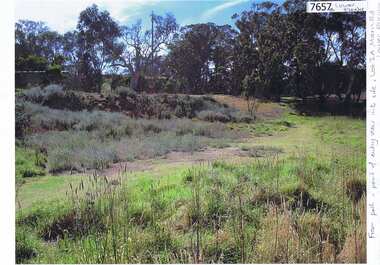
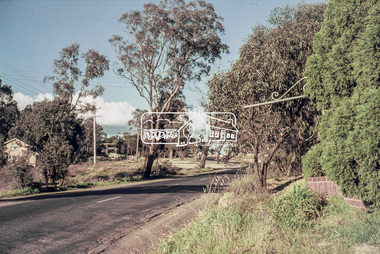
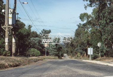
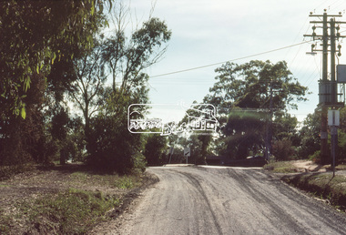
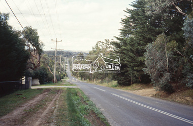
Slide, Bonds Road, Lower Plenty, Mar. 1981
... Bonds Road, Lower Plenty...road...lower plenty...One of a series of images of road infrastructure focussed on Bonds Road, Lower Plenty, the section connecting Old Eltham Road with Rosehill Road, taken by Eltham Shire Council Planning and Engineering officers. ...All images have been identified with GPS infrastructure roads bonds road lower plenty Rosehill Road Processed Mar 1981 35 mm colour positive transparency (1 of 13) Mount - Kodak Kodachrome Card Bonds Road, Lower Plenty Slide Slide ...One of a series of images of road infrastructure focussed on Bonds Road, Lower Plenty, the section connecting Old Eltham Road with Rosehill Road, taken by Eltham Shire Council Planning and Engineering officers. They provide perspective of the changes in housing styles and road development that began sweeping in from the mid 1970s with increasing urbanisation of what was once more outlying suburbs and regions. All images have been identified with GPS35 mm colour positive transparency (1 of 13) Mount - Kodak Kodachrome CardProcessed Mar 1981infrastructure, roads, bonds road, lower plenty, rosehill road -
 Eltham District Historical Society Inc
Slide, Bonds Road, Lower Plenty, Mar. 1981
... Bonds Road, Lower Plenty...road...lower plenty...One of a series of images of road infrastructure focussed on Bonds Road, Lower Plenty, the section connecting Old Eltham Road with Rosehill Road, taken by Eltham Shire Council Planning and Engineering officers. ...All images have been identified with GPS infrastructure roads bonds road lower plenty rosehill road Processed Mar 1981 35 mm colour positive transparency (1 of 13) Mount - Kodak Kodachrome Card Bonds Road, Lower Plenty Slide Slide ...One of a series of images of road infrastructure focussed on Bonds Road, Lower Plenty, the section connecting Old Eltham Road with Rosehill Road, taken by Eltham Shire Council Planning and Engineering officers. They provide perspective of the changes in housing styles and road development that began sweeping in from the mid 1970s with increasing urbanisation of what was once more outlying suburbs and regions. All images have been identified with GPS35 mm colour positive transparency (1 of 13) Mount - Kodak Kodachrome CardProcessed Mar 1981infrastructure, roads, bonds road, lower plenty, rosehill road -
 Eltham District Historical Society Inc
Photograph, Odyssey House Victoria, 28 Bonds Road, Lower Plenty, 6 March 1990
... Odyssey House Victoria, 28 Bonds Road, Lower Plenty...lower plenty...bonds road...Odyssey House drug rehabilitation centre in Bonds Road, Lower Plenty is a distinctive landmark, especially when viewed from across the Yarra at Templestowe. ...road access, a suspension footbridge was built across the river. As well as providing easy access for the priests residents of Templestowe could attend services at the seminary. The bridge is now part of the Yarra Trails system. lower plenty ...Odyssey House drug rehabilitation centre in Bonds Road, Lower Plenty is a distinctive landmark, especially when viewed from across the Yarra at Templestowe. It was built in the 1950’s as a seminary for the Blessed Sacrament Fathers. Because of the poor and circuitous road access, a suspension footbridge was built across the river. As well as providing easy access for the priests residents of Templestowe could attend services at the seminary. The bridge is now part of the Yarra Trails system.Colour photographlower plenty, bonds road, odyssey house -
 Eltham District Historical Society Inc
Photograph, Looking east along Main Road, Lower Plenty approaching the top of the hill and Grand Boulevard, July 1969, 1969
... Looking east along Main Road, Lower Plenty approaching the top of the hill and Grand Boulevard, July 1969...Ambulance Station, Apex-Diamond Valley Ambulance Station, Eltham Ambulance Station, Eltham Apex Club, Lower Plenty, Main Road, Montmorency...In 1970, Eltham Shire Council undertook roadworks to construct Apex Way in preparation for the new station as well as duplicate Main Road, Lower Plenty, east of Grand Boulevard including the new Lower Plenty Bridge, which had been opened in November 1966, bordering with the City of Heidelberg....Ambulance Station, Apex-Diamond Valley Ambulance Station, Eltham Ambulance Station, Eltham Apex Club, Lower Plenty, Main Road, Montmorency 35mm colour positive transparency blue Agfacolour Service plastic mount Looking east along Main Road, Lower Plenty approaching the top of the hill and Grand Boulevard, July 1969 Photograph ...The Eltham Apex Club conducted a Community Service Project (1965-1968) to raise funds for a new Ambulance Station to service the community. A site bounded by the intersection of Main Road, Grand Boulevard and Looker Road at Montmorency was purchased in 1969. In 1970, Eltham Shire Council undertook roadworks to construct Apex Way in preparation for the new station as well as duplicate Main Road, Lower Plenty, east of Grand Boulevard including the new Lower Plenty Bridge, which had been opened in November 1966, bordering with the City of Heidelberg.35mm colour positive transparency blue Agfacolour Service plastic mountambulance station, apex-diamond valley ambulance station, eltham ambulance station, eltham apex club, lower plenty, main road, montmorency -
 Greensborough Historical Society
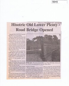
Newspaper - Newspaper Clipping, Banyule Observer, Historic Old Lower Plenty Road Bridge Opened, 31/03/2001
... Historic Old Lower Plenty Road Bridge Opened...Banyule City Council has reopened the Old Lower Plenty Bridge. lower plenty bridge lower plenty river bridge. plenty river Newspaper clipping with black text with black and white photo. Historic Old Lower Plenty Road ...Banyule City Council has reopened the Old Lower Plenty Bridge.Newspaper clipping with black text with black and white photo.lower plenty bridge, lower plenty river bridge., plenty river -
 Eltham District Historical Society Inc
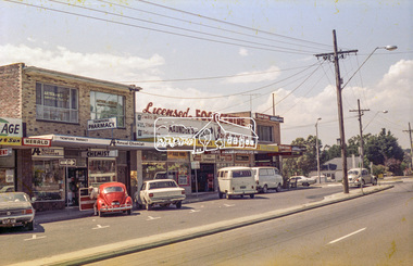
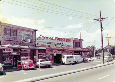
Photograph, Lower Plenty shops, Main Road, c.1976, 1976c
... Lower Plenty shops, Main Road, c.1976...lower plenty...shops...main road...Main Road, Lower Plenty, Victoria...Eltham District Historical Society Inc 728 Main Rd Eltham melbourne Streetscape development over time lower plenty shops main road shoe inn maunder's food store Agfa CNS Roll of 35mm colour negative film, 2 strips Lower Plenty shops, Main Road, c.1976 Photograph ...Streetscape development over timeRoll of 35mm colour negative film, 2 stripsAgfa CNSlower plenty, shops, main road, shoe inn, maunder's food store -
 Eltham District Historical Society Inc
Photograph, Lower Plenty shops, Main Road, c.1976, 1976c
... Lower Plenty shops, Main Road, c.1976...lower plenty...shops...main road...Main Road, Lower Plenty, Victoria...Eltham District Historical Society Inc 728 Main Rd Eltham melbourne Streetscape development over time lower plenty shops main road Colour photograph Lower Plenty shops, Main Road, c.1976 Photograph ...Streetscape development over timeColour photographlower plenty, shops, main road -
 Eltham District Historical Society Inc
Slide, Bonds Road, Lower Plenty, Mar. 1981
... Bonds Road, Lower Plenty...Road...Lower Plenty...One of a series of images of road infrastructure focussed on Bonds Road, Lower Plenty, the section connecting Old Eltham Road with Rosehill Road, taken by Eltham Shire Council Planning and Engineering officers. ...All images have been identified with GPS infrastructure roads Bonds Road Lower Plenty Old Eltham Road Processed Mar 1981 35 mm colour positive transparency (1 of 13) Mount - Kodak Kodachrome Card Bonds Road, Lower Plenty Slide Slide ...One of a series of images of road infrastructure focussed on Bonds Road, Lower Plenty, the section connecting Old Eltham Road with Rosehill Road, taken by Eltham Shire Council Planning and Engineering officers. They provide perspective of the changes in housing styles and road development that began sweeping in from the mid 1970s with increasing urbanisation of what was once more outlying suburbs and regions. All images have been identified with GPS35 mm colour positive transparency (1 of 13) Mount - Kodak Kodachrome CardProcessed Mar 1981infrastructure, roads, bonds road, lower plenty, old eltham road -
 Eltham District Historical Society Inc
Slide, Bonds Road, Lower Plenty, Mar. 1981
... Bonds Road, Lower Plenty...road...lower plenty...One of a series of images of road infrastructure focussed on Bonds Road, Lower Plenty, the section connecting Old Eltham Road with Rosehill Road, taken by Eltham Shire Council Planning and Engineering officers. ...All images have been identified with GPS infrastructure roads bonds road lower plenty Old Eltham Road Processed Mar 1981 35 mm colour positive transparency (1 of 13) Mount - Kodak Kodachrome Card Bonds Road, Lower Plenty Slide Slide ...One of a series of images of road infrastructure focussed on Bonds Road, Lower Plenty, the section connecting Old Eltham Road with Rosehill Road, taken by Eltham Shire Council Planning and Engineering officers. They provide perspective of the changes in housing styles and road development that began sweeping in from the mid 1970s with increasing urbanisation of what was once more outlying suburbs and regions. All images have been identified with GPS35 mm colour positive transparency (1 of 13) Mount - Kodak Kodachrome CardProcessed Mar 1981infrastructure, roads, bonds road, lower plenty, old eltham road -
 Eltham District Historical Society Inc
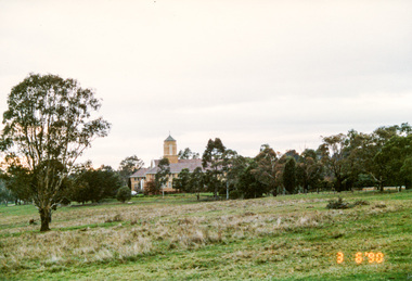
Slide - Photograph, Rosehill Road, Lower Plenty, c.June 1990
... Rosehill Road, Lower Plenty...lower plenty...Rosehill Road...Eltham District Historical Society Inc 728 Main Rd Eltham melbourne roads lower plenty Rosehill Road 35mm colour positive transparency (1 of 36) Mount - Agfa CS System grey 8 dots Rosehill Road, Lower Plenty Slide Photograph ...35mm colour positive transparency (1 of 36) Mount - Agfa CS System grey 8 dotsroads, lower plenty, rosehill road -
 Eltham District Historical Society Inc
Photograph, Looking west along Old Eltham Road towards intersection with Main Road, Lower Plenty, 1968, 1968
... Looking west along Old Eltham Road towards intersection with Main Road, Lower Plenty, 1968...Lower Plenty, Main Road, Old Eltham Road...Ol Eltham Road, Lower Plenty, Victoria, Australia...Eltham District Historical Society Inc 728 Main Rd Eltham melbourne Lower Plenty, Main Road, Old Eltham Road 35mm Colour positive transparency Mount - Agfacolor Service (Blue stepped) Looking west along Old Eltham Road towards intersection with Main Road, Lower Plenty, 1968 Photograph ...35mm Colour positive transparency Mount - Agfacolor Service (Blue stepped)lower plenty, main road, old eltham road