Showing 67 items matching "lower templestowe"
-
 Kew Historical Society Inc
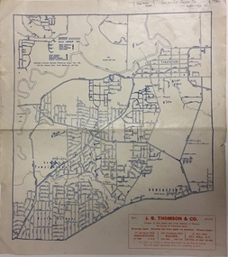
Map, Real Estate Map of Bulleen, Templestowe, Lower Templestowe, Doncaster, North Balwyn
... Real Estate Map of Bulleen, Templestowe, Lower Templestowe, Doncaster, North Balwyn......lower templestowe...A large undated printed map of Bulleen, Templestowe, Lower Templestowe, Doncaster, North Balwyn showing major and minor roads, waterways and proposed facilities in this area of Melbourne....Map of Bulleen, Templestowe, Lower Templestowe, Doncaster, North Balwyn used by JB Thomson & Co, Real Estate Agents, to identify and record land sales on these. ...Real Estate Map of Bulleen, Templestowe, Lower Templestowe, Doncaster, North Balwyn Map Map ...A large undated printed map of Bulleen, Templestowe, Lower Templestowe, Doncaster, North Balwyn showing major and minor roads, waterways and proposed facilities in this area of Melbourne.A useful if undated real estate map that allows viewers to compare current and historic aspects of these areasMap of Bulleen, Templestowe, Lower Templestowe, Doncaster, North Balwyn used by JB Thomson & Co, Real Estate Agents, to identify and record land sales on these. There are some markings on the plan indicating the location and price of lots.subdivision plans, bulleen, templestowe, lower templestowe, doncaster, north balwyn -
 Melbourne Tram Museum
Ephemera - Timetables - MMTB Buses - set of 13, Melbourne & Metropolitan Tramways Board (MMTB), 1971 to 1973
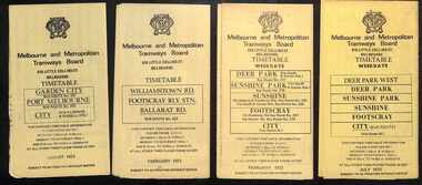
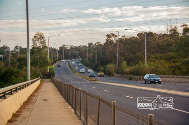
... ...Lower Templestowe...Not all services had been allocated a route number at the time. 1 - Garden City - Port Melbourne - City - routes 201, 202 - August 1972 2 - Williamstown Road - Footscray - Ballarat Rd - Route 223, Feb. 1972 3 - Deer Park, Sunshine Park, Sunshine, Footscray - City - routes 217, 219, 220, 229, 231 and 218 - Feb. 1972 4 - Deer Park West, Sunshine Park, Sunshine, Footscray - City - July 1973 5 - Fishermen's Bend - City - routes 233, 235 and 237 - March 1972 6 - Clifton Hill - Esternwick - Point Ormond - routes 246, 247 and 248 - August 1972 7 - Latrobe Uni - Northland - West Heidelberg - City - routes 256, 251, 253, 254, 252 and 255 August 1972 8 - East Kew, Box Hill, Doncaster, Shoppingtown - routes 284, 285 and 270 - July 1972 9 - Box Hill, Mitcham, East Doncaster, Ringwood - routes 287, 286, 288, 282, 283, and 272 - July 1972 10 - Box Hill - North Blackburn, route 290, printed on white paper - Sep. 1971 11 - Box Hill - Doncaster, Shoppingtown, Heidelberg, Templestowe, Serpells Rd and Lower Templestowe - routes 293, 296, 297, 271 - July 1972 12 Deer Park, Sunshine Park, Sunshine, Footscray - City - routes 217, 219, 220, 229, 231 and 218 - Saturdays and Sundays, printed on green paper - Feb. 1972 13 - Fishermans Bend - City - routes 233, 235 and 237 - June 1973 ...Not all services had been allocated a route number at the time. 1 - Garden City - Port Melbourne - City - routes 201, 202 - August 1972 2 - Williamstown Road - Footscray - Ballarat Rd - Route 223, Feb. 1972 3 - Deer Park, Sunshine Park, Sunshine, Footscray - City - routes 217, 219, 220, 229, 231 and 218 - Feb. 1972 4 - Deer Park West, Sunshine Park, Sunshine, Footscray - City - July 1973 5 - Fishermen's Bend - City - routes 233, 235 and 237 - March 1972 6 - Clifton Hill - Esternwick - Point Ormond - routes 246, 247 and 248 - August 1972 7 - Latrobe Uni - Northland - West Heidelberg - City - routes 256, 251, 253, 254, 252 and 255 August 1972 8 - East Kew, Box Hill, Doncaster, Shoppingtown - routes 284, 285 and 270 - July 1972 9 - Box Hill, Mitcham, East Doncaster, Ringwood - routes 287, 286, 288, 282, 283, and 272 - July 1972 10 - Box Hill - North Blackburn, route 290, printed on white paper - Sep. 1971 11 - Box Hill - Doncaster, Shoppingtown, Heidelberg, Templestowe, Serpells Rd and Lower Templestowe - routes 293, 296, 297, 271 - July 1972 12 Deer Park, Sunshine Park, Sunshine, Footscray - City - routes 217, 219, 220, 229, 231 and 218 - Saturdays and Sundays, printed on green paper - Feb. 1972 13 - Fishermans Bend - City - routes 233, 235 and 237 - June 1973 Yields information about MMTB Bus services during the 1970s. timetable MMTB buses Port Melbourne Garden City Williamstown Rd Footscray Ballarat Rd Sunshine Deer Park Fisherman's Bend Clifton Hill Esternwick Point Ormond La Trobe university Northland West Heidelberg East Kew Box Hill Doncaster Shoppingtown Mitcham Ringwood Blackburn Templestowe Lower Templestowe Fishermans Bend Set of twelve MMTB Bus timetables - multifolded printed on yellow paper, unless noted otherwise. ...Timetables - provide information on ticketing, fares, timing points, with a description of the route and a map. Not all services had been allocated a route number at the time. 1 - Garden City - Port Melbourne - City - routes 201, 202 - August 1972 2 - Williamstown Road - Footscray - Ballarat Rd - Route 223, Feb. 1972 3 - Deer Park, Sunshine Park, Sunshine, Footscray - City - routes 217, 219, 220, 229, 231 and 218 - Feb. 1972 4 - Deer Park West, Sunshine Park, Sunshine, Footscray - City - July 1973 5 - Fishermen's Bend - City - routes 233, 235 and 237 - March 1972 6 - Clifton Hill - Esternwick - Point Ormond - routes 246, 247 and 248 - August 1972 7 - Latrobe Uni - Northland - West Heidelberg - City - routes 256, 251, 253, 254, 252 and 255 August 1972 8 - East Kew, Box Hill, Doncaster, Shoppingtown - routes 284, 285 and 270 - July 1972 9 - Box Hill, Mitcham, East Doncaster, Ringwood - routes 287, 286, 288, 282, 283, and 272 - July 1972 10 - Box Hill - North Blackburn, route 290, printed on white paper - Sep. 1971 11 - Box Hill - Doncaster, Shoppingtown, Heidelberg, Templestowe, Serpells Rd and Lower Templestowe - routes 293, 296, 297, 271 - July 1972 12 Deer Park, Sunshine Park, Sunshine, Footscray - City - routes 217, 219, 220, 229, 231 and 218 - Saturdays and Sundays, printed on green paper - Feb. 1972 13 - Fishermans Bend - City - routes 233, 235 and 237 - June 1973 Yields information about MMTB Bus services during the 1970s. Set of twelve MMTB Bus timetables - multifolded printed on yellow paper, unless noted otherwise. timetable, mmtb, buses, port melbourne, garden city, williamstown rd, footscray, ballarat rd, sunshine, deer park, fisherman's bend, clifton hill, esternwick, point ormond, la trobe university, northland, west heidelberg, east kew, box hill, doncaster, shoppingtown, mitcham, ringwood, blackburn, templestowe, lower templestowe, fishermans bend -
 Melbourne Tram Museum
Ephemera - Timetables - MMTB Buses - set of 9, Melbourne & Metropolitan Tramways Board (MMTB), 1976 to 1978
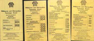
... ...Lower Templestowe...Not all services had been allocated a route number at the time. 1 - Garden City - Port Melbourne - City - routes 201 and 202 - Jan. 1977 2 - Bulleen - North Kew City - Routes 203, 204, 205, 206, 208 and 209 - Feb. 1977 3 - Deer Park West - Sunshine - Footscray - City - routes 215, 216, 217, 219. 218, 220, 231 with a Saturdays and Sundays timetable sheet printed on green paper - Aug. 1977 4 - La Trobe University - Northland - West Heidelberg - City - routes 256, 251, 253, 254, 252, 255 - Sept. 1978 5- Warrandyte - Park Orchards - Ringwood - routes 273, 274, 275 - June 1976 6 - Warrandyte - Donvale - Templestowe - Shoppingtown - City - routes 276, 277, 278, 294, 278, 280, 299, 268 - July 1976 7 - Box Hill - Mitcham, East Doncaster, Ringwood - routes 287, 286, 288, 282, 283, 272 - June 1976 8 - Box Hill - North Blackburn - route 290 - June 1976 9 - Box Hill - Heidelberg, East Doncaster, Shopping town - routes 291, 297, 296, 293, 271 and 269 - Sept. 1976 Yields information about MMTB Bus services during the mid 1970s. timetable MMTB buses Port Melbourne Garden City Deer Park Fisherman's Bend West Heidelberg Box Hill Doncaster Shoppingtown Mitcham Ringwood Blackburn Templestowe Lower Templestowe Set of nine MMTB Bus timetables - multifolded printed on yellow paper, unless noted otherwise. ...Timetables - provide information on ticketing, fares, timing points, with a description of the route and a map. Not all services had been allocated a route number at the time. 1 - Garden City - Port Melbourne - City - routes 201 and 202 - Jan. 1977 2 - Bulleen - North Kew City - Routes 203, 204, 205, 206, 208 and 209 - Feb. 1977 3 - Deer Park West - Sunshine - Footscray - City - routes 215, 216, 217, 219. 218, 220, 231 with a Saturdays and Sundays timetable sheet printed on green paper - Aug. 1977 4 - La Trobe University - Northland - West Heidelberg - City - routes 256, 251, 253, 254, 252, 255 - Sept. 1978 5- Warrandyte - Park Orchards - Ringwood - routes 273, 274, 275 - June 1976 6 - Warrandyte - Donvale - Templestowe - Shoppingtown - City - routes 276, 277, 278, 294, 278, 280, 299, 268 - July 1976 7 - Box Hill - Mitcham, East Doncaster, Ringwood - routes 287, 286, 288, 282, 283, 272 - June 1976 8 - Box Hill - North Blackburn - route 290 - June 1976 9 - Box Hill - Heidelberg, East Doncaster, Shopping town - routes 291, 297, 296, 293, 271 and 269 - Sept. 1976Yields information about MMTB Bus services during the mid 1970s. Set of nine MMTB Bus timetables - multifolded printed on yellow paper, unless noted otherwise. timetable, mmtb, buses, port melbourne, garden city, deer park, fisherman's bend, west heidelberg, box hill, doncaster, shoppingtown, mitcham, ringwood, blackburn, templestowe, lower templestowe -
 Whitehorse Historical Society Inc.
Functional object - Snake Bite Kit, circa 1960's
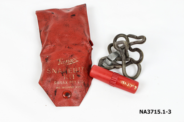
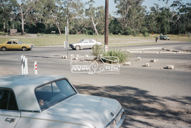
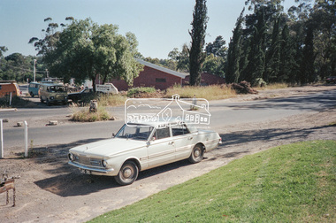
... The Gunning family owned 20 acres of orchard and farm land in High Street Lower Templestowe and kept one of these kits in each vehicle and tractor. ...Whitehorse Historical Society Inc. 2-10 Deep Creek Road Mitcham melbourne The Gunning family owned 20 acres of orchard and farm land in High Street Lower Templestowe and kept one of these kits in each vehicle and tractor. ...The Gunning family owned 20 acres of orchard and farm land in High Street Lower Templestowe and kept one of these kits in each vehicle and tractor. They didn't experience a snake problem until the late 1950's when land sub division around their property forced snakes into the area. The family lost one dog to snake bite in the early 1960's.Consists of a Wallet, tourniquet and lancet . 1.Wallet - small red plastic wallet with one press stud to close. Printed in gold on front: 'Sanax Snakebite Kit Sanax Pty Ltd Melbourne Australia 2.Tourniquet - rubber tourniquet looped through a metal clip used to tighten tourniquet. ' Sanax ' embossed on flat of metal clip. 3.Lancet - a three chambered cylindrical container made of red plastic. One end removes to reveal a lancet/ blade, the other end acts as a handle for the blade. Container holds instructions on a small roll of paper. The centre of the container can be be unscrewed to access crystals of permanganate of potash to put on the woundmedicine, first aid -
 Eltham District Historical Society Inc
Photograph, Looking north from Fitzsimons Lane Bridge, c.May 2001
... Viewed from the boundary of Eltham, Lower Plenty and Templestowe...Eltham District Historical Society Inc 728 Main Rd Eltham melbourne Viewed from the boundary of Eltham, Lower Plenty and Templestowe eltham streets main road fitzsimons lane fitzsimons lane bridge Agfa HDC 200 plus-2 Roll of 35mm colour negative film, 7 strips Looking north from Fitzsimons Lane Bridge Photograph Photograph ...Viewed from the boundary of Eltham, Lower Plenty and TemplestoweRoll of 35mm colour negative film, 7 stripsAgfa HDC 200 plus-2eltham, streets, main road, fitzsimons lane, fitzsimons lane bridge -
 Eltham District Historical Society Inc
Document - Folder, Tunn, Syd and Henderson, Wendi
... Syd Tunn exhibiting at Gallery 21 Lower templestowe. Card of painting by Syd Tunn. ...Syd Tunn exhibiting at Gallery 21 Lower templestowe. Card of painting by Syd Tunn. ...Artists Syd Tunn and Wendi Henderson life and work at Bend of Isles. Contents Newspaper article: "Opted for a new style", Diamond Valley News, 7 December 1982. Syd Tunn exhibiting at Gallery 21 Lower templestowe. Card of painting by Syd Tunn. Flier for Open Studios: Syd Tunn and Ona Henderson, 14-15 November (no year, probably 1996), Flier for Open Studios: Ona and Syd's Open Studio, 5-6 May 2018. Newspaper clippings, A4 photocopies, etcbend of isles, watson's creek, syd tunn, wendi henderson, ona henderson, bend of islands, nillumbik artists open studios, henley road kangaroo ground, oxley road kangaroo ground -
Eltham District Historical Society Inc
Document - Folder, Sibbel Builders Pty Ltd
... Contents Manningham Heritage Study report, 68-70 Olympus Drive, Lower Templestowe, 8 July 2005, pp260-261: Background of Sibbel Builders Printout: Research information, Sibbel Builders Pty Ltd. ...Contents Manningham Heritage Study report, 68-70 Olympus Drive, Lower Templestowe, 8 July 2005, pp260-261: Background of Sibbel Builders Printout: Research information, Sibbel Builders Pty Ltd. ...Sibbel Builders was a partnership of brothers Herman and Martin Sibbel; they lived in Eltham. Their daughters Wilhelmina McCarroll and Fleur Sibbel founded the furniture design company Zuster. Contents Manningham Heritage Study report, 68-70 Olympus Drive, Lower Templestowe, 8 July 2005, pp260-261: Background of Sibbel Builders Printout: Research information, Sibbel Builders Pty Ltd. Details of Wilhelmina McCarroll and Fleur Sibbel and furniture design company Zuster. Newspaper advertisement: Diamond Valley Leader, 25 June 2008. 19 Spring Street, Greensborough, a Sibbel Classic house [reverse: 43 Para Road, Montmorency].Newspaper clippings, A4 photocopies, etcwilhelmina mccarroll, fleur sibbel, zuster furniture design, martin sibbel, herman sibbel, sibbel builders pty ltd, 19 spring street greensborough, 43 para road montmorency -
 Melbourne Legacy
Newspaper - Article, The Age, Governor Take the Reins, 1960
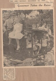
... Also a photo is of Mickey Hodder, 11, of Lower Templestowe and Ivy Murray, 5, of Box Hill. ...Also a photo is of Mickey Hodder, 11, of Lower Templestowe and Ivy Murray, 5, of Box Hill. ...Newspaper articles about the Christmas Party held at Government House in 1960. One is from The Age on 12 December 1960 and two from The Herald on the same day. Melbourne Legacy would hold Christmas parties for junior Legatees at Government House for many years due to the Governor of Victoria being patron of Legacy. Two photos show the Governor Sir Dallas Brooks the reins of a miniature mail coach drawn by two small ponies. Sitting with the Governor is 10 year old Sandra Fitzpatrick of Moe. Children would come from all over Victoria. Two other photos show archery with the Kew City Bowman providing instruction of archery to the children. Judith Berry was instructing Ken Barberis 8 years old. Also a photo is of Mickey Hodder, 11, of Lower Templestowe and Ivy Murray, 5, of Box Hill. The articles were cut from the newspaper and pasted into a scrap book of press clippings. For many years Legacy kept scrap books of press clippings that related to their work and publicity.A record of relationship of Legacy with the Governor of Victoria and the parties that Legacy provided for the children in their care.Newspaper article of the Government House Christmas Party in 1960 pasted to brown page of a scrap book.junior legatees, junior legatee outing, christmas, government house party -
 Eltham District Historical Society Inc
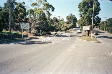
Negative - Photograph, Main Road, Eltham, c.Dec. 1983
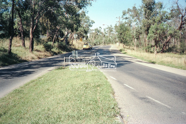
... Traffic to Lower Plenty and Templestowe to be diverted down Bridge Street (and Bolton Street) effective January 1984. ...Traffic to Lower Plenty and Templestowe to be diverted down Bridge Street (and Bolton Street) effective January 1984. ...Road sign advising of proposed reconstruction works of Main Road to install a roundabout at Mount Pleasant Road. Traffic to Lower Plenty and Templestowe to be diverted down Bridge Street (and Bolton Street) effective January 1984. The proposed roundabout did not proceed. Instead traffic islands on Mount Pleasant Road were installed in place of temporary blocked out islands.Film - Kodak CM 400 5079 7 strips, 26 framesinfrastructure, roads, road construction, roundabout, road sign, main road, mount pleasant road -
 Eltham District Historical Society Inc
Negative - Photograph, Intersection of Mt Pleasant Road at Main Road, Eltham, c.Dec. 1983
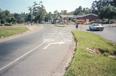
... Traffic to Lower Plenty and Templestowe to be diverted down Bridge Street (and Bolton Street) effective January 1984. ...Traffic to Lower Plenty and Templestowe to be diverted down Bridge Street (and Bolton Street) effective January 1984. ...Reconstruction work was planned for Main Road to install a roundabout at Mount Pleasant Road. Traffic to Lower Plenty and Templestowe to be diverted down Bridge Street (and Bolton Street) effective January 1984. The proposed roundabout did not proceed. Instead traffic islands on Mount Pleasant Road were installed in place of temporary blocked out islands and revised extended driveway to properties 622-642 Main Road with access off Mount Pleasant Road instead.Film - Kodak CM 400 5079 7 strips, 26 framesinfrastructure, roads, road construction, roundabout, road sign, main road, mount pleasant road, eltham -
 Eltham District Historical Society Inc
Negative - Photograph, Intersection of Mt Pleasant Road at Main Road, Eltham, c.Dec. 1983
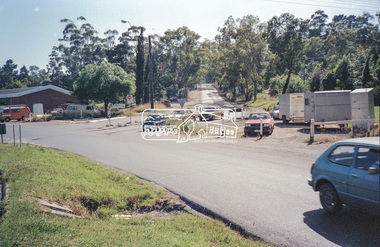
... Traffic to Lower Plenty and Templestowe to be diverted down Bridge Street (and Bolton Street) effective January 1984. ...Traffic to Lower Plenty and Templestowe to be diverted down Bridge Street (and Bolton Street) effective January 1984. ...Reconstruction work was planned for Main Road to install a roundabout at Mount Pleasant Road. Traffic to Lower Plenty and Templestowe to be diverted down Bridge Street (and Bolton Street) effective January 1984. The proposed roundabout did not proceed. Instead traffic islands on Mount Pleasant Road were installed in place of temporary blocked out islands and revised extended driveway to properties 622-642 Main Road with access off Mount Pleasant Road instead.Film - Kodak CM 400 5079 7 strips, 26 framesinfrastructure, roads, road construction, roundabout, road sign, main road, mount pleasant road, eltham -
 Eltham District Historical Society Inc
Negative - Photograph, Intersection of Mt Pleasant Road at Main Road, Eltham, c.Dec. 1983
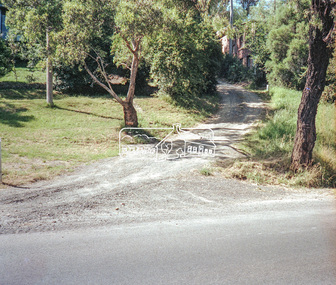
... Traffic to Lower Plenty and Templestowe to be diverted down Bridge Street (and Bolton Street) effective January 1984. ...Traffic to Lower Plenty and Templestowe to be diverted down Bridge Street (and Bolton Street) effective January 1984. ...Reconstruction work was planned for Main Road to install a roundabout at Mount Pleasant Road. Traffic to Lower Plenty and Templestowe to be diverted down Bridge Street (and Bolton Street) effective January 1984. The proposed roundabout did not proceed. Instead traffic islands on Mount Pleasant Road were installed in place of temporary blocked out islands and revised extended driveway to properties 622-642 Main Road with access off Mount Pleasant Road instead.Film - Kodak CM 400 5079 7 strips, 26 framesinfrastructure, roads, road construction, roundabout, road sign, main road, mount pleasant road, eltham -
 Eltham District Historical Society Inc
Negative - Photograph, Intersection of Mt Pleasant Road at Main Road, Eltham, c.Dec. 1983
... Traffic to Lower Plenty and Templestowe to be diverted down Bridge Street (and Bolton Street) effective January 1984. ...Traffic to Lower Plenty and Templestowe to be diverted down Bridge Street (and Bolton Street) effective January 1984. ...Reconstruction work was planned for Main Road to install a roundabout at Mount Pleasant Road. Traffic to Lower Plenty and Templestowe to be diverted down Bridge Street (and Bolton Street) effective January 1984. The proposed roundabout did not proceed. Instead traffic islands on Mount Pleasant Road were installed in place of temporary blocked out islands and revised extended driveway to properties 622-642 Main Road with access off Mount Pleasant Road instead.Film - Kodak CM 400 5079 7 strips, 26 framesinfrastructure, roads, road construction, roundabout, road sign, main road, mount pleasant road, eltham, service station -
 Eltham District Historical Society Inc
Negative - Photograph, Intersection of Mt Pleasant Road at Main Road, Eltham, c.Dec. 1983
... Traffic to Lower Plenty and Templestowe to be diverted down Bridge Street (and Bolton Street) effective January 1984. ...Traffic to Lower Plenty and Templestowe to be diverted down Bridge Street (and Bolton Street) effective January 1984. ...Reconstruction work was planned for Main Road to install a roundabout at Mount Pleasant Road. Traffic to Lower Plenty and Templestowe to be diverted down Bridge Street (and Bolton Street) effective January 1984. The proposed roundabout did not proceed. Instead traffic islands on Mount Pleasant Road were installed in place of temporary blocked out islands and revised extended driveway to properties 622-642 Main Road with access off Mount Pleasant Road instead.Film - Kodak CM 400 5079 7 strips, 26 framesinfrastructure, roads, road construction, roundabout, road sign, main road, mount pleasant road, eltham -
 Eltham District Historical Society Inc
Negative - Photograph, Intersection of Mt Pleasant Road at Main Road, Eltham, c.Dec. 1983
... Traffic to Lower Plenty and Templestowe to be diverted down Bridge Street (and Bolton Street) effective January 1984. ...Traffic to Lower Plenty and Templestowe to be diverted down Bridge Street (and Bolton Street) effective January 1984. ...Reconstruction work was planned for Main Road to install a roundabout at Mount Pleasant Road. Traffic to Lower Plenty and Templestowe to be diverted down Bridge Street (and Bolton Street) effective January 1984. The proposed roundabout did not proceed. Instead traffic islands on Mount Pleasant Road were installed in place of temporary blocked out islands and revised extended driveway to properties 622-642 Main Road with access off Mount Pleasant Road instead.Film - Kodak CM 400 5079 7 strips, 26 framesinfrastructure, roads, road construction, roundabout, road sign, main road, mount pleasant road, eltham -
 Eltham District Historical Society Inc
Film - Video (VHS), Nillumbik Shire Council, The Nillumbik Story, 1996
... Lower Park...Environment...fishing...flour mill...fruit growing...fruiterer...Garden Hill...Gold mining...Green Wedge...Greensborough...Heritage Trail...Hurstbridge Railway Line...jazz festival...Jock Ryan...Kangaroo Ground...kangaroo ground tower...Kinglake...Maroondah Aqueduct...Matcham Skipper...Memorial Park...Ming Mackay (1918-2009)...Montsalvat...Mudbrick houses...Music...musicians...nesting area...Nillumbik Historical Society...Nillumbik Shire...North Warrandyte...Old timer...Orchards...Peter Brock...Plenty River...poets...Population...Recreation...recreational activities...revegetation...Robert Hoddle...Sandy Brock...Shillinglaw Cottage...Shire of Eltham War Memorial...Sigmund Jorgensen...St Andrews Hotel...St Andrews Market...Sugarloaf Reservoir...Templestowe...CREDITS Music by John Greenfield from the CD Sweet Rain “The Snow Tree”, Uncle Music UNC 2001 Cameras - David Mirabella and Peter Farragher Editor – Olwyn Jones Written and Produced by Jason Cameron A Jason Cameron Proction for Nillumbik Shire Provides a record of the relatively newly created Shire of Nillumbik at the time and the features and attactions of the shire in its people arts, culture and environment video recording Arthurs Creek Arthurs Creek Landcare group Artists artists in residence Arts Arts Festival Authors BlackBerry Brock family Bulldozer Bulleen bushland sanctuary Caledonian gold rush Charles Reddington Clifton Pugh cottlesbridge Cypress rows developer Diamond Creek Diamond Creek Mine Diamond Reef Diamond Valley miniature railway Doncaster dunmoochin Education program EEPS Eltham Eltham East Primary School Eltham East Primary School Band Eltham Library Community Gallery Eltham Lower Park Environment fishing flour mill fruit growing fruiterer Garden Hill Gold mining Green Wedge Greensborough Heritage Trail Hurstbridge Railway Line jazz festival Jock Ryan Kangaroo Ground kangaroo ground tower Kinglake Maroondah Aqueduct Matcham Skipper Memorial Park Ming Mackay (1918-2009) Montsalvat Mudbrick houses Music musicians nesting area Nillumbik Historical Society Nillumbik Shire North Warrandyte Old timer Orchards Peter Brock Plenty River poets Population Recreation recreational activities revegetation Robert Hoddle Sandy Brock Shillinglaw Cottage Shire of Eltham War Memorial Sigmund Jorgensen St Andrews Hotel St Andrews Market Sugarloaf Reservoir Templestowe The Hill tourism Viewing platform Warrandyte water catchment area Watsons Creek Wedgetail eagle Whittlesea Wiregrass Gallery Wurundjeri Yarra River Jack Powell VHS Cassette (five copies) DVD (one copy) Converted to MP4 file format 0:22:00, 1.60GB The Nillumbik Story Film Video (VHS) Nillumbik Shire Council Jason Cameron David Mirabella Peter Farragher Olwyn Jones ...PART 1 – NILLUMBIK (00:00-07:17) Opening features various scenes around Nillumbik Shire. For 40,000 years Nillumbik was the home of the Wurundjeri people. Robert Hoddle gave the district its name. Jock Ryan, then president of Nillumbik Historical Society discusses the names Nillumbik and Diamond Creek. In the late 1830s white occupation began with gold found in Warrandyte in 1851 and 12 years later at Diamond Creek -the Diamond Reef which led to the Caledonian gold rush. Jock Ryan discusses the Diamond Creek mine, which was thriving until it burnt out in 1915. Large numbers of workmen moved into area in late 1870s to construct the Maroondah Aqueduct. With growing population of Melbourne, the nearby Yan Yean system had severely disrupted the flow of the Plenty River, forcing the closure of three flour mills there. The aqueduct came to the rescue carrying water 66km from Healesville to Preston. When the Diamond Creek gold mine burnt down the local economy suffered but fruit growing industry had already been established and Diamond Creek became a thriving fruit growing centre. Interview with Jack Powell, a long-time fruiterer at St Andrews market, his family had lived in the area for a hundred years, 3 to 4 generations, “a lot of hard work”. By the time the railway arrived fruit growing was no longer competitive. The railway brought the city closer and day trippers. The Green Wedge separates the shire from the more densely developed neighbours such as Whittlesea, Doncaster, Templestowe, Bulleen and Greensborough. Population at the time (1996) was 19,000 but links to the past remain strong. Mudbrick houses along the Heritage Trail The saving of Shillinglaw Cottage from demolition in 1963 and relocation brick by brick. PART 2 – ENVIRONMENT (07:18-14:44) Peter Brock (with Bev Brock in background) at St Andrews market discusses his childhood growing up in the district and the environment and the values it instilled upon him and his own family. The Brocks have been in the district since the 1860s. Nillumbik Shire responsible for managing three catchment areas; Diamond Creek, Arthurs Creek and Watsons Creek. Follows the course of the Diamond Creek commencing in Kinglake through the district to its confluence with the Yarra River at Eltham at Eltham Lower Park. Highlights Eltham Lower Park community revegetation program and the newly constructed (1996) viewing platform built of new and recycled timbers at the confluence of the Diamond Creek and Yarra River. Also featured are outdoor recreation on the river and at Eltham Lower Park including the Diamond Valley miniature railway. Sugarloaf reservoir and recreational activities and fishing. Aerial view of Memorial Park and Shire of Eltham War Memorial tower at Garden Hill, Kangaroo Ground. Significant tourism opportunities for the shire with 3 million potential day-trippers in metropolitan Melbourne. Council and community working together to find a way to promote the shires natural and artistic assets. At Arthurs Creek, the Brock family and neighbours working together to take care of their waterway. Peter Brock’s uncle, Sandy Brock talks about environmental management and the Arthurs Creek Landcare group and actions to eradicate blackberry problem. Having previously planted Cypress rows they are replacing them with indigenous species to improve the water supply, keeping cattle out of the creek bed to improve the quality downstream flowing into the Yarra. Eltham East Primary School Band playing “All things bright and beautiful” merges into scenes of the bushland sanctuary set aside by the school in 1980 with unidentified teacher discusses the sanctuary and their education program and school children’s comments. Plight of a family of Wedgetail eagles nesting in the path of a developer’s bulldozer at North Warrandyte and actions to save their nesting areas. PART 3 – ARTS (14:45-22:00) Arts and Jazz festival at Montsalvat featuring interviews with Sigmund Jorgensen discussing Montsalvat and its principles. Also Matcham Skipper. Clifton Pugh’s funeral at Montsalvat and his legacy at Dunmoochin near Cottlesbridge with artists in residence, at the time, Chicago artist Charles Reddington who discusses the benefits of the experience. An unidentified female artist also talks about the program and why people are drawn to the area. Unidentified man on street talking about the amount of talent in the area, artists, poets, musicians, authors. Artist Ming Mackay (1918-2009) interviewed talking about the people she mixes with on “the Hill”. Works of local artists are displayed Eltham Library Community Gallery and Wiregrass gallery with a new coffee shop at the Wiregrass making it an even more popular destination. Music at St Andrews Hotel (may be a little bit country) and the Saturday market where likely to hear anything. Sellers and patrons at the market asked about what attracts them to the market and where they came from. Scenes of poets/authors giving readings. CREDITS Music by John Greenfield from the CD Sweet Rain “The Snow Tree”, Uncle Music UNC 2001 Cameras - David Mirabella and Peter Farragher Editor – Olwyn Jones Written and Produced by Jason Cameron A Jason Cameron Proction for Nillumbik ShireProvides a record of the relatively newly created Shire of Nillumbik at the time and the features and attactions of the shire in its people arts, culture and environmentVHS Cassette (five copies) DVD (one copy) Converted to MP4 file format 0:22:00, 1.60GBvideo recording, arthurs creek, arthurs creek landcare group, artists, artists in residence, arts, arts festival, authors, blackberry, brock family, bulldozer, bulleen, bushland sanctuary, caledonian gold rush, charles reddington, clifton pugh, cottlesbridge, cypress rows, developer, diamond creek, diamond creek mine, diamond reef, diamond valley miniature railway, doncaster, dunmoochin, education program, eeps, eltham, eltham east primary school, eltham east primary school band, eltham library community gallery, eltham lower park, environment, fishing, flour mill, fruit growing, fruiterer, garden hill, gold mining, green wedge, greensborough, heritage trail, hurstbridge railway line, jazz festival, jock ryan, kangaroo ground, kangaroo ground tower, kinglake, maroondah aqueduct, matcham skipper, memorial park, ming mackay (1918-2009), montsalvat, mudbrick houses, music, musicians, nesting area, nillumbik historical society, nillumbik shire, north warrandyte, old timer, orchards, peter brock, plenty river, poets, population, recreation, recreational activities, revegetation, robert hoddle, sandy brock, shillinglaw cottage, shire of eltham war memorial, sigmund jorgensen, st andrews hotel, st andrews market, sugarloaf reservoir, templestowe, the hill, tourism, viewing platform, warrandyte, water catchment area, watsons creek, wedgetail eagle, whittlesea, wiregrass gallery, wurundjeri, yarra river, jack powell -
 Eltham District Historical Society Inc
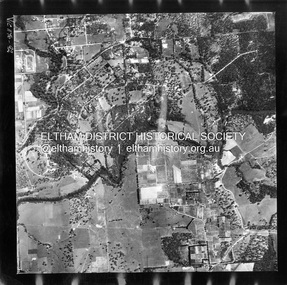
Photograph - Aerial Photograph, Landata, Eltham, Feb. 1956
... Lower Park...Hohnes Road...Melway 22B8...Monckton Road...Mount Pleasant Road...Petty's Orchard...Reynolds Road...Sweeneys Lane...Templestowe...Centred on present day Culla Hill and Petty's Orchard, Eltham bounded by Brougham Street and Mount Pleasant Road to north, Monckton Road, Templestowe to south, Reynolds Road to east and Eltham Lower Park and Hohnes Road to west. ...Eltham District Historical Society Inc 728 Main Rd Eltham melbourne Centred on present day Culla Hill and Petty's Orchard, Eltham bounded by Brougham Street and Mount Pleasant Road to north, Monckton Road, Templestowe to south, Reynolds Road to east and Eltham Lower Park and Hohnes Road to west. ...Centred on present day Culla Hill and Petty's Orchard, Eltham bounded by Brougham Street and Mount Pleasant Road to north, Monckton Road, Templestowe to south, Reynolds Road to east and Eltham Lower Park and Hohnes Road to west. Historic Aerial Imagery Source: Landata.vic.gov.au Aerial Photo Details: Project No :250 Project : MELBOURNE OUTER SUBURBS PROJECT Run : 18 Frame : 92 Date : 02/1956 Film Type : B/W Camera : EAG9 Flying Height : 10000 Scale : 12000 Film Number : 1176 GDA2020 : 37°43'35"S, 145°09'31"E MGA2020 : 337735, 5822959 (55) Melways : 22 B8 (ed. 42)aerial photo, 1956-02, neil webster collection, eltham, brougham steet, culla hill, eltham lower park, hohnes road, melway 22b8, monckton road, mount pleasant road, petty's orchard, reynolds road, sweeneys lane, templestowe, yarra river -
 Eltham District Historical Society Inc
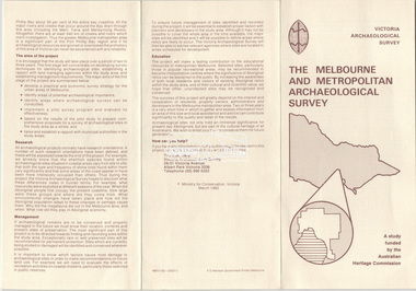
Document - Folder, Victoria Archaeological Survey, 1982-1990
... Flyer: The Archaeological Survey of the Middle Yarra, the Lower Plenty River and the City of Doncaster and Templestowe, 1990...Flyer: The Archaeological Survey of the Middle Yarra, the Lower Plenty River and the City of Doncaster and Templestowe, 1990 Victoria Archaeological Survey Document Folder ...sites, structures, archaeological significance, victoria archaeological survey -
 Eltham District Historical Society Inc
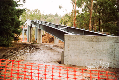
Photograph, Doug Orford, Commencement of bridge works across Yarra River at rear of Eltham Lower Park, May 2004, 2004
... templestowe...eltham lower park...Eltham District Historical Society Inc 728 Main Rd Eltham melbourne bridges yarra river eltham eltham south templestowe eltham lower park lenister farm homestead road Two colour photographs showing commencement of construction of Eltham-Templestowe footbridge over Yarra River off Homestead Road, Eltham which was completed July 2004. ...Two colour photographs showing commencement of construction of Eltham-Templestowe footbridge over Yarra River off Homestead Road, Eltham which was completed July 2004.bridges, yarra river, eltham, eltham south, templestowe, eltham lower park, lenister farm, homestead road -
 Eltham District Historical Society Inc
Photograph, Doug Orford, Bridge works across Yarra River at rear of Eltham Lower Park, June 2004, 2004
... templestowe...eltham lower park...Eltham District Historical Society Inc 728 Main Rd Eltham melbourne bridges yarra river eltham eltham south templestowe eltham lower park lenister farm homestead road Three colour photographs showing commencement of construction of Eltham-Templestowe footbridge over Yarra River off Homestead Road, Eltham which was completed July 2004. ...Three colour photographs showing commencement of construction of Eltham-Templestowe footbridge over Yarra River off Homestead Road, Eltham which was completed July 2004.bridges, yarra river, eltham, eltham south, templestowe, eltham lower park, lenister farm, homestead road -
 Eltham District Historical Society Inc
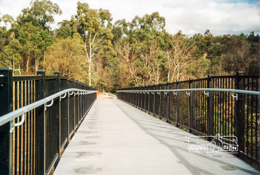
Photograph, Doug Orford, Completion of bridge works across Yarra River at rear of Eltham Lower Park, July 2004, July 2004
... Templestowe footbridge over the Yarra River off Homestead Road, Eltham which was completed in July 2004. The Yarra River Footbridge was opened in August 2004 and links the Diamond Creek Trail between the Shire of Nillumbik and City of Manningham. It is a shared pathway and also links with the Main Yarra Trail. It affords lovely views over the Yarra River. yarra river eltham south eltham lower ...Brand new Eltham-Templestowe footbridge over the Yarra River off Homestead Road, Eltham which was completed in July 2004. The Yarra River Footbridge was opened in August 2004 and links the Diamond Creek Trail between the Shire of Nillumbik and City of Manningham. It is a shared pathway and also links with the Main Yarra Trail. It affords lovely views over the Yarra River.One of three colour photographs.yarra river, eltham south, eltham lower park, lenister farm, homestead road, shared pathway, diamond creek trail, footbridge -
 Eltham District Historical Society Inc
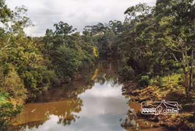
Photograph, Doug Orford, Yarra River from Eltham-Templestowe Footbridge, 2004, 2004
... templestowe...eltham lower park...Eltham District Historical Society Inc 728 Main Rd Eltham melbourne yarra river bridges eltham eltham south templestowe eltham lower park lenister farm Two colour photographs of Yarra River upstream and downstream from Eltham-Templestowe footbridge Yarra River from Eltham-Templestowe Footbridge, 2004 Photograph Doug Orford ...Two colour photographs of Yarra River upstream and downstream from Eltham-Templestowe footbridgeyarra river, bridges, eltham, eltham south, templestowe, eltham lower park, lenister farm -
 Eltham District Historical Society Inc
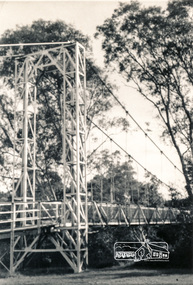
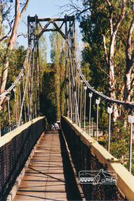
Photograph, Pedestrian suspension bridge over the Yarra River at Lower Plenty
... Odyssey House drug rehabilitation centre in Bonds Road, Lower Plenty is a distinctive landmark, especially when viewed from across the Yarra at Templestowe. ...Eltham District Historical Society Inc 728 Main Rd Eltham melbourne Odyssey House drug rehabilitation centre in Bonds Road, Lower Plenty is a distinctive landmark, especially when viewed from across the Yarra at Templestowe. ...Odyssey House drug rehabilitation centre in Bonds Road, Lower Plenty is a distinctive landmark, especially when viewed from across the Yarra at Templestowe. It was built in the 1950’s as a seminary for the Blessed Sacrament Fathers. Because of the poor and circuitous road access, a suspension footbridge was built across the river. As well as providing easy access for the priests residents of Templestowe could attend services at the seminary. The bridge is now part of the Yarra Trails system.Two black and white photographs of footbridge over Yarra River, part of the Ruffey Trail just off the Main Yarra Trail near the former seminary (now Odyssey House) Lower Plentybridges, yarra river, odyssey house, bonds road, lower plenty, seminary, blessed sacrament fathers -
 Eltham District Historical Society Inc
Photograph, Pedestrian suspension bridge over the Yarra River at Lower Plenty
... Odyssey House drug rehabilitation centre in Bonds Road, Lower Plenty is a distinctive landmark, especially when viewed from across the Yarra at Templestowe. ...Eltham District Historical Society Inc 728 Main Rd Eltham melbourne Odyssey House drug rehabilitation centre in Bonds Road, Lower Plenty is a distinctive landmark, especially when viewed from across the Yarra at Templestowe. ...Odyssey House drug rehabilitation centre in Bonds Road, Lower Plenty is a distinctive landmark, especially when viewed from across the Yarra at Templestowe. It was built in the 1950’s as a seminary for the Blessed Sacrament Fathers. Because of the poor and circuitous road access, a suspension footbridge was built across the river. As well as providing easy access for the priests residents of Templestowe could attend services at the seminary. The bridge is now part of the Yarra Trails system.Colour photograph of footbridge over Yarra River, part of the Ruffey Trail just off the Main Yarra Trail near the former seminary (now Odyssey House) Lower Plentybridges, yarra river, lower plenty, seminary, blessed sacrament fathers, odyssey house, bonds road -
 Greensborough Historical Society
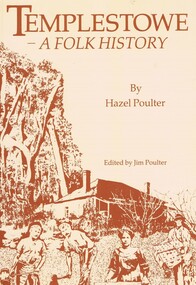
Book, Hazel Poulter, Templestowe - a folk history, 1985_
... Greensborough Historical Society 34A Glenauburn Road Lower Plenty Lower Plenty melbourne A short history of Templestowe. templestowe Author's presentation copy 1987 114 p., black & white photos. 2 copies. ...A short history of Templestowe.114 p., black & white photos. 2 copies.Author's presentation copy 1987templestowe -
 Greensborough Historical Society
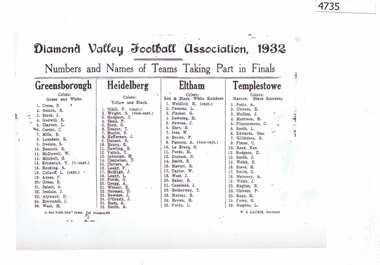
Document, Diamond Valley Football Association, Diamond Valley Football Association, 1932, 1932_
... Greensborough Historical Society 34A Glenauburn Road Lower Plenty Lower Plenty melbourne Numbers and names of teams taking part in Diamond Valley Football Association finals 1932. Greensborough, Heidelberg, Eltham and Templestowe Football Clubs. diamond valley football association greensborough football club 1 page, copy of team list Diamond Valley Football Association, 1932 Document Document Diamond Valley Football Association ...Numbers and names of teams taking part in Diamond Valley Football Association finals 1932. Greensborough, Heidelberg, Eltham and Templestowe Football Clubs.1 page, copy of team listdiamond valley football association, greensborough football club