Showing 284 items matching "mackenzie river"
-
 Halls Gap & Grampians Historical Society
Photograph - B/W
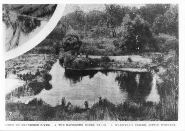
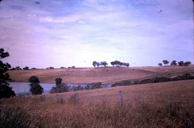
... ...MacKenzie River...Oddly, the inscription on the bottom of the photo does not appear to relate to the images. SCENERY MacKenzie River Photo shows a river with four people standing on a sandy bank. ...This is the pondage below Wartook Lake embankment. The photo is from the Weekly Times. Oddly, the inscription on the bottom of the photo does not appear to relate to the images.Photo shows a river with four people standing on a sandy bank. Four other people can be seen in the forgrouns standing on the near bank. A smaller inset at the top left corner seems to show a tee reflected in water.scenery, mackenzie river -
 Orbost & District Historical Society
newspaper clipping, Orbost Forty Years Ago, 1929?
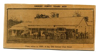
... In June 1889 there was a rush to Mackenzie River, about 28 miles from Orbost, on Twelve Mile Creek. ...In June 1889 there was a rush to Mackenzie River, about 28 miles from Orbost, on Twelve Mile Creek. ...The first hotel built in Orbost was the Club in 1885 an old wooden place on the corner built for J. A. Petersen of the Mitchell Hotel Bairnsdale, with the licence in the name of Mr Thomas Maguire (stepson of Petersen). In June 1889 there was a rush to Mackenzie River, about 28 miles from Orbost, on Twelve Mile Creek. An estimated 80 men rushed the ground, but yields were patchy and large numbers eventually left. They were coming and going almost daily.The Club Hotel was the first hotel built in Orbost and remains a significant building in the town. It was an important hub for the township with many whole town meetings held there.A yellowed black / white newspaper clipping of a photograph of people with a horse and cart outside a one-storey hotel building. It is glued onto a piece of cardboard.Caption at bottom - "View taken in 1889 of the Old Orbost Club Hotel"orbost-club-hotel -
 Orbost & District Historical Society
black and white photograph, C 1890s
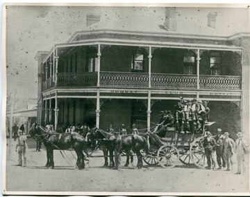
... In June 1889 there was a rush to Mackenzie River, about 28 miles from Orbost, on Twelve Mile Creek. ...In June 1889 there was a rush to Mackenzie River, about 28 miles from Orbost, on Twelve Mile Creek. ...The first hotel built in Orbost was the Club in 1885 an old wooden place on the corner built for J. A. Petersen of the Mitchell Hotel Bairnsdale, with the licence in the name of Mr Thomas Maguire (stepson of Petersen). William Archer was the proprietor at the time of the photograph. The coach driver was Sam Dyer and the coach is leaving for the goldfields at Combienbar. In June 1889 there was a rush to Mackenzie River, about 28 miles from Orbost, on Twelve Mile Creek. An estimated 80 men rushed the ground, but yields were patchy and large numbers eventually left. They were coming and going almost daily.The Club Hotel was the first hotel built in Orbost and remains a significant building in the town. It was an important hub for the township with many whole town meetings held there.A faded black / white photograph (with two copies) with a horse-drawn carriage loaded with men and the Orbost Club Hotel behind them. The photo is on a grey buff card.on back - " H. Adams. Driven by Sam Dyer - Leaving for the Combienbar Goldfields"orbost-club-hotel combienbar-goldfields -
 Stawell Historical Society Inc
Photograph, Postcard set c.1940
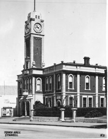
... This is a popular walk in the Wonderland Range. 11 The Whale’s Mouth Wonderland Range Grampians 12 Relph Peak in the Wonderland Range looking down on the Fyans Valley and Halls Gap 13 Bellfield Peak is part of the Wonderland Range overlooking Halls Gap and the Fyans Valley 14 Gateway of the East Winds on the Wonderland Walk 15 Mackenzie Falls on the Mackenzie River and downstream from Wartook Reservoir. ...This is a popular walk in the Wonderland Range. 11 The Whale’s Mouth Wonderland Range Grampians 12 Relph Peak in the Wonderland Range looking down on the Fyans Valley and Halls Gap 13 Bellfield Peak is part of the Wonderland Range overlooking Halls Gap and the Fyans Valley 14 Gateway of the East Winds on the Wonderland Walk 15 Mackenzie Falls on the Mackenzie River and downstream from Wartook Reservoir. ...-1 Stawell Town Hall, with newly constructed clocktower -2 Main Street, Looking west towards the Grampians -3 Stawell from Big Hill, looking west towards the Grampians 4 Cato Lake, looking west towards the railway line. Swimming Club Rooms on the Left, Bandstand on the Right 5 The Gardens Sundial, donated by the family of Edward Simmons who owned the Oriental Gold Mine 6 Central Park Sports Oval looking north to the Grandstand. Cricket match being played. This is the site of the annual running of the Stawell Gift. 7 Pioneers’ Memorial on Big Hill. Built in 1938 and a popular viewing area of Stawell and the Grampians Mountain Range. 8 Sisters Rocks, on London Road and the Western Highway corner. It has been a popular place for graffiti for decades. 9 The Balconies (also known as the “ Jaws of Death ) Mt Victory Grampians. It is near Reids lookout and both have excellent views of the Victoria Valley. 10 The Grand Canyon Grampians. This is a popular walk in the Wonderland Range. 11 The Whale’s Mouth Wonderland Range Grampians 12 Relph Peak in the Wonderland Range looking down on the Fyans Valley and Halls Gap 13 Bellfield Peak is part of the Wonderland Range overlooking Halls Gap and the Fyans Valley 14 Gateway of the East Winds on the Wonderland Walk 15 Mackenzie Falls on the Mackenzie River and downstream from Wartook Reservoir. This is a popular visiting place for tourists. 16 Wartook Reservoir, serving as part of Horsham’s water supply. Black & White Photograph Postcards Setstawell tourism -
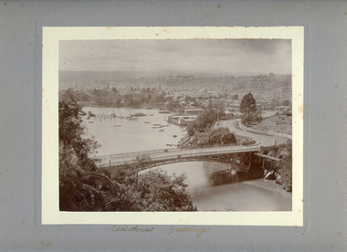 Bendigo Historical Society Inc.
Photograph - VIEW OF LAUNCESTON FROM CATARACT GORGE, c.early 1900's
... History House 11 Mackenzie Street Bendigo goldfields PLACE Landscape view launceston tasmania W Vincent Kelly, Mitchell St., Bendigo Sepia photo on grey mount of elevated view of river with single span bridge, with boats moored. ...Sepia photo on grey mount of elevated view of river with single span bridge, with boats moored. Swimming baths in centre to right. Town with church spires and houses and hills in background. Inscriptions 'Christmas Greetings' gold ink underneath photo. On back - written in pencil 'City of Launceston, Tasmania from Cataract Gorge'.W Vincent Kelly, Mitchell St., Bendigoplace, landscape view, launceston, tasmania -
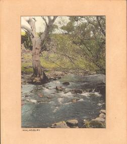 Bendigo Historical Society Inc.
Photograph - STREAM AT MALMSBURY
... History House 11 Mackenzie Street Bendigo goldfields PLACE Landscape view See also 2001.152.01 2001.153.01 2001.154.01 2001.157.01 2001.158.01 2001.159.01 2001.160.01 2001.162.01 Francil (Frank) Thomas Kennedy Photograph, hand tinted. Stream at Malmsbury (Coliban River ...Photograph, hand tinted. Stream at Malmsbury (Coliban River). History: with note 'Photographs from Mrs Ella Bourke, 131 Barnard St, Bendigo, ph 438269'. Photographs Francis (Frank) Thomas Kennedy'. James Lerk 'Coliban River'??Francil (Frank) Thomas Kennedyplace, landscape view, see also 2001.152.01, 2001.153.01, 2001.154.01, 2001.157.01, 2001.158.01, 2001.159.01, 2001.160.01, 2001.162.01 -
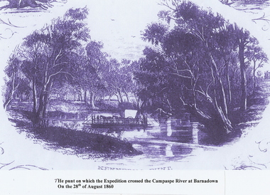 Bendigo Historical Society Inc.
Photograph - PUNT, CAMPASPE RIVER BARNADOWN
... History House 11 Mackenzie Street Bendigo goldfields TOPIC Art punt camaspe river Photocopy: Punt on Campaspe River at Barnadown on August 28th, 1860. ...Photocopy: Punt on Campaspe River at Barnadown on August 28th, 1860. Used to ferry Bourke & Wills across the river. Picture is a photocopy of a sketch. The punt was possibly called KENNEY'S PUNT.topic, art, punt, camaspe river -
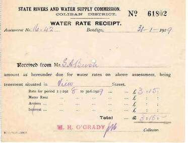 Bendigo Historical Society Inc.
Document - BUSH COLLECTION: RECEIPTS AND NOTICES FOR THE PROVISION OF SERVICES, 1920 - 1930
... History House 11 Mackenzie Street Bendigo goldfields PERSON Individual bush collection - personal Collection of approximately 22 receipts and notices pertaining to S. A. Bush. Includes documents from Bendigo Sewerage Authority, State Rivers ...Collection of approximately 22 receipts and notices pertaining to S. A. Bush. Includes documents from Bendigo Sewerage Authority, State Rivers and Water Supply Commission, Bendigo Gas Company, Plus Dividend Notices from The Colonial Gas Association Limited.person, individual, bush collection - personal -
 Bendigo Historical Society Inc.
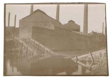
Photograph - ROBERT DENIS KELLY COLLECTION: BRIDGE TO SOUS LE BOIS
... History House 11 Mackenzie Street Bendigo goldfields PERSON Robert denis kelly world war 1 bridge France Sous Le Bois. Black and white photo: bridge over river, bridge is collapsed in middle. ...Black and white photo: bridge over river, bridge is collapsed in middle. Written on back 'Bridge to Sous Le Bois'.person, robert denis kelly, world war 1, bridge, france, sous le bois. -
 Bendigo Historical Society Inc.
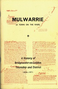
Book - MULWARRIE A TOWN ON THE RIVER A HISTORY OF BRIDGWATER-0N-LODDON TOWNSHIP AND DISTRICT 1836-1971, 1971
... History House 11 Mackenzie Street Bendigo goldfields HISTORY bridgewater Back to Bridgewater Committee 1971 'Mulwarrie' (A Town on the River). ...'Mulwarrie' (A Town on the River). A History of Bridgewater-on-Loddon Township and District 1836-1971. Publisher: Jim Lowden Printing, Kilmore 3601. 80 pages. Photographs & illustrations. Bridgewater-on -Loddon History. Inscriptions: Bendigo Historical Society.Back to Bridgewater Committee 1971history, bridgewater -
 Bendigo Historical Society Inc.
Photograph - ROBERT DENIS KELLY COLLECTION: RIVER WITH BRIDGE
... History House 11 Mackenzie Street Bendigo goldfields PERSON Robert denis kelly world war 1 France bridge Manteuge Black and white photo: river with bridge overhead. ...Black and white photo: river with bridge overhead. On back of photo 'Gamaches'?person, robert denis kelly, world war 1, france, bridge, manteuge -
 Bendigo Historical Society Inc.
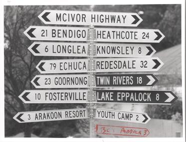
Photograph - BENDIGO ADVERTISER COLLECTION: SIGN POST AT AXEDALE, 16/06/1993
... History House 11 Mackenzie Street Bendigo goldfields REGION Small towns Axedale Bill Hawking Sign post at Axedale on the McIvor Highway indicating the distance to nearby places. Places named: Bendigo, Heathcote, Longlea, Knowsley, Echuca, Redesdale, Goornong, Twin Rivers, Fosterville, Lake Eppalock, Arakoon Resort, Youth Camp. ...Sign post at Axedale on the McIvor Highway indicating the distance to nearby places. Places named: Bendigo, Heathcote, Longlea, Knowsley, Echuca, Redesdale, Goornong, Twin Rivers, Fosterville, Lake Eppalock, Arakoon Resort, Youth Camp.Bill Hawkingregion, small towns, axedale -
 Bendigo Historical Society Inc.
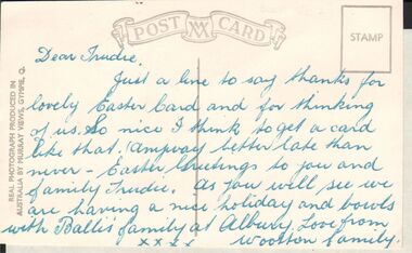
Postcard - GERTRUDE PERRY COLLECTION: POSTCARD MURRAY RIVER
... History House 11 Mackenzie Street Bendigo goldfields POSTCARD Photograph Murray River A black and white postcard to a Trudie thanking her for Easter card from the Woolton family. ...A black and white postcard to a Trudie thanking her for Easter card from the Woolton family. The postcard is a view of the Murray river at Albury NSW.postcard, photograph, murray river -
 Bendigo Historical Society Inc.
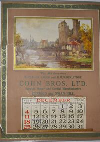
Domestic Object - COHN BROTHERS COLLECTION: CALENDAR FOR DECEMBER, 1938
... History House 11 Mackenzie Street Bendigo goldfields BENDIGO History Cohn Brothers Cohn Brothers France Maurice Levis Cohn Brother's Calendar for December 1938. The Calendar features a painting by the French artist Maurice Levis featuring a painting of a French river flowing through a large castle town, on the left side there is a family of three about to push their boat into the river.. ...Cohn Brother's Calendar for December 1938. The Calendar features a painting by the French artist Maurice Levis featuring a painting of a French river flowing through a large castle town, on the left side there is a family of three about to push their boat into the river.. Below the painting has the following text along with the December Calendar itself "Where Life Flows Gently on Its Way From Painting by Maurice Levis For All Ocasionals 6 0'CLOCK LAGER and 7 0'CLOCK STOUT COHN BROS. LTD. Aerated Water and Cordial Manufacturers BENDIGO and SWAN HILL. The Calendar itself also has dates left behind by its first owner such as the anniversary of his Father's death on the 1st and two other dates on the 19th and 20th that are slightly difficult to read.bendigo, history, cohn brothers, cohn brothers, france, maurice levis -
 Bendigo Historical Society Inc.
Photograph - ROBERT DENIS KELLY COLLECTION: BRIDGE OVER RIVER
... History House 11 Mackenzie Street Bendigo goldfields Black and white photo: a double arch bridge over river. ...Black and white photo: a double arch bridge over river. On the back: Bridge Biesmes. -
 Bendigo Historical Society Inc.
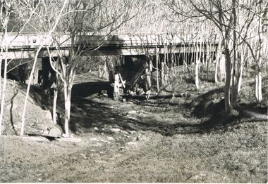
Photograph - 'MARYDALE' AXEDALE COLLECTION: PHOTOGRAPH DRY CREEK BED
... History House 11 Mackenzie Street Bendigo goldfields AXEDALE History Marydale Property Photograph.View of dry river bed, probably Campaspe River, Axedale, with open land with bridge crossing, at ''Marydale'', Axedale. ...Photograph.View of dry river bed, probably Campaspe River, Axedale, with open land with bridge crossing, at ''Marydale'', Axedale.axedale, history, marydale property -
 Bendigo Historical Society Inc.
Slide - EPPALOCK. CONSTRUCTION, c1962
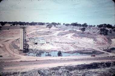
... History House 11 Mackenzie Street Bendigo goldfields CIVIL ENGINEERING Water supply Eppalock Kodak Eppalock. Construction. Shows water in the bottom of the lake, or possibly river running into it. ...Eppalock. Construction. Shows water in the bottom of the lake, or possibly river running into it. Markings: Eppalock Dam. Dec 1962 near Lyal.Kodakcivil engineering, water supply, eppalock -
 Bendigo Historical Society Inc.
Slide - DAVID MCDONALD COLLECTION: EPPALOCK. CONSTRUCTION, c1963
... History House 11 Mackenzie Street Bendigo goldfields CIVIL ENGINEERING Water supply Eppalock Agfacolor Eppalock. Construction. Water going down to the Campaspe River from the spillway. ...Eppalock. Construction. Water going down to the Campaspe River from the spillway.Agfacolorcivil engineering, water supply, eppalock -
 Bendigo Historical Society Inc.
Slide - DAVID MCDONALD COLLECTION: EPPALOCK. CONSTRUCTION, c1960
... Mackenzie Street Bendigo goldfields CIVIL ENGINEERING Water supply Eppalock Agfacolor Eppalock. Construction. Slide shows the water tower, workmen's huts and some trucks etc. Shows large pool of water with another of to the right these would have been part of Coliban River. ...Eppalock. Construction. Slide shows the water tower, workmen's huts and some trucks etc. Shows large pool of water with another of to the right these would have been part of Coliban River.Agfacolorcivil engineering, water supply, eppalock -
 Bendigo Historical Society Inc.
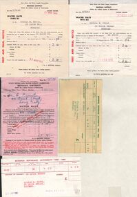
Document - L. PROUT COLLECTION: WATER RATES
... History House 11 Mackenzie Street Bendigo goldfields ORGANIZATION Public utility water Seven invoices from the State Rivers and Water Supply Commission from 1960 to 1962 plus 2 receipt for payments. ...Seven invoices from the State Rivers and Water Supply Commission from 1960 to 1962 plus 2 receipt for payments. The invoices are in the name of Lilian M. Prout, 24 Quick Street, Bendigoorganization, public utility, water -
 Bendigo Historical Society Inc.
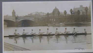
Photograph - PHOTOGRAPH OF ROWING TEAM, 1920
... History House 11 Mackenzie Street Bendigo goldfields ORGANIZATION Club/society rowing team Rowing Team Yarra River Burlington Burlington Melb Black and white photograph of an 8 man rowing team on the Yarra River Melbourne showing city buildings in the background, mounted on grey card within a thin black wooden frame, markings read 'Burlington Melb' Photograph PHOTOGRAPH OF ROWING TEAM ...Black and white photograph of an 8 man rowing team on the Yarra River Melbourne showing city buildings in the background, mounted on grey card within a thin black wooden frame, markings read 'Burlington Melb'Burlington Melborganization, club/society, rowing team, rowing team, yarra river, burlington -
 Bendigo Historical Society Inc.
Document - BASIL WATSON COLLECTION: NEWSPAPER CUTTINGS (ARGUS, 1861) RE MURRAY RIVER RAILWAY, 1861
... History House 11 Mackenzie Street Bendigo goldfields PERSON Individual basil watson Newspaper cuttings (Argus,8 July 1861) re Murray River Railway. enclosed in a buff envelope 'The Australasian T.& G. ...Newspaper cuttings (Argus,8 July 1861) re Murray River Railway. enclosed in a buff envelope 'The Australasian T.& G. Mutual Life, Assurance Society Ltd.letterhead on exterior. a. 'Progress of the works' 2/7/1861; b. 'Opening of the line to Woodend' 8/7/1861; c. Paragraph on first official train trip to Woodend (Argus? 7/1861) Connection to Watson family possibly through mention of Mr. G.W. Knight, the district engineer of the Sunbury section of the railway.person, individual, basil watson -
 Bendigo Historical Society Inc.
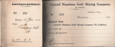
Document - MCCOLL, RANKIN AND STANISTREET COLLECTION: CENTRAL NAPOLEON GOLD MINING CO. N.L, 24 Jan 1938 - 18 Sep 1942
... History House 11 Mackenzie Street Bendigo goldfields ORGANIZATION Business industrial - mining McColl Rankin & Stanistreet mining gold mining Central Napoleon Document: Hard Cover Crocodile deisgn with dark blue binding, receipt book Nos 201 - 298 used, 299 - 300 Unused, Receipt No 218 made out to 'State Rivers & Water' written out but never removed folded into buts, receipt No 277 removed, folded then pinned to but (3 pins) pins rusted, Markings read 'Central Napoleon' on a label on the spine. ...Document: Hard Cover Crocodile deisgn with dark blue binding, receipt book Nos 201 - 298 used, 299 - 300 Unused, Receipt No 218 made out to 'State Rivers & Water' written out but never removed folded into buts, receipt No 277 removed, folded then pinned to but (3 pins) pins rusted, Markings read 'Central Napoleon' on a label on the spine.organization, business, industrial - mining, mccoll rankin & stanistreet, mining, gold mining, central napoleon -
 Bendigo Historical Society Inc.
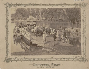
Photograph - HOPWOODS PUNT, RIVER MURRAY
... History House 11 Mackenzie Street Bendigo goldfields PLACE Transport hopwoods punt river murray T.F. ...sepia print, showing Murray River scene. Punt carrying wagon, horse drawn, with wool bales, spring cart and figures on foot on punt. Dinghy on water below operator of cable winding machine. Five adult males on landing stage. One covered wagon and two wagons loaded with bales on NSW bank. On front, T.F,. Chuck, Photo, Melbourne. On back in blue ink : From Mrs. Marjorie Vahland, presented to the Bendigo Historical Society. The gentleman with umbrella in the foreground of the punt is her father, the Bendigo architect of pioneering fame. 'T.F. Chuck, Melbourneplace, transport, hopwoods punt, river murray -
 Bendigo Historical Society Inc.
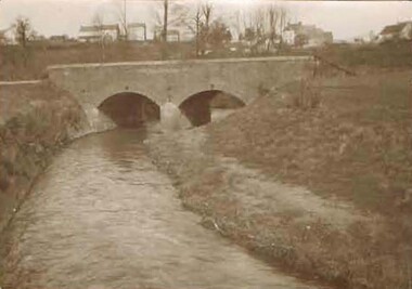
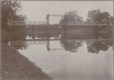
Photograph - BRIDGE - SINGLE SPAN
... History House 11 Mackenzie Street Bendigo goldfields BRIDGE Construction single span lift bridge M. Clifton ? sepia photo on grey board: single span lift bridge across river. ...sepia photo on grey board: single span lift bridge across river. Long truss spans each side of lift section. Probably over Murray River ? On front rop right corner Mp 107. On back written ' copies obtainable from M. Clifton, Koondrook'M. Clifton ?bridge, construction, single span lift bridge -
 Bendigo Historical Society Inc.
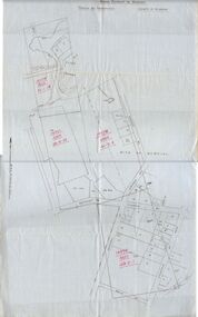
Document - MCCOLL, RANKIN AND STANISTREET COLLECTION: MAP OF MINE LEASES SYMONDS STREET, MCKENZIE ST WEST AREA BENDIGO, 2nd September, 1936
... Map indicates gully leading into and State Rivers and Water supply reservoir, water race; siphon, shaft, dam, residential area and some residential lots marked. Streets include Holly Street, MacKenzie...Mackenzie Street Bendigo goldfields BENDIGO Mining mccoll rankin & stanistreet Blue waxed linen paper map. On top' Mining District of Bendigo' Parish of Sandhurst, County of Bendigo' Map shows lease 10135, area 32.1.19; lease 10371, area 30.0.23; lease 10179 area 41.3.4; lease 10370, area 49.0.1. Map indicates gully leading into and State Rivers ...Blue waxed linen paper map. On top' Mining District of Bendigo' Parish of Sandhurst, County of Bendigo' Map shows lease 10135, area 32.1.19; lease 10371, area 30.0.23; lease 10179 area 41.3.4; lease 10370, area 49.0.1. Map indicates gully leading into and State Rivers and Water supply reservoir, water race; siphon, shaft, dam, residential area and some residential lots marked. Streets include Holly Street, MacKenzie Street West, Symonds Street, Aspinall Street, Emmett Street; Bendigo Creek marked at bottom of map. Scale 4 chains to one inch. Map is not dated.bendigo, mining, mccoll rankin & stanistreet -
 Bendigo Historical Society Inc.
Magazine - AILEEN AND JOHN ELLISON COLLECTION: THE NEW NATION MAGAZINE
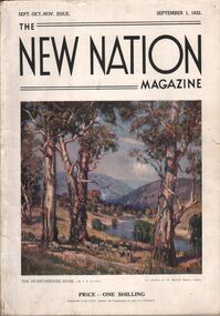
... History House 11 Mackenzie Street Bendigo goldfields BOOK Magazine The New Nation The New Nation Magazine Sept. Oct. Nov. Issue. September 1, 1932. On the front cover a painting "The Murrumbidgee River by J. ...The New Nation Magazine Sept. Oct. Nov. Issue. September 1, 1932. On the front cover a painting "The Murrumbidgee River by J. R. Jackson. Price 1 shilling the magazine has 112 pages, the last two pages are ripped and the back cover is missing. Contents: Frontispiece "morning of the dogger bank" (by T. Benetter)- The British commonwealth of Nations - Switzerland, land of lakes and mountains (by Hilary lofting) - Highways of the Syrian desert (by Francis Birtles) - Seven ages of the Australian aboriginal - The game of the empire, the approaching cricket test matches (by M. A. Noble) - Short story, the last run (by H. H. Cardinal) - "The hidden bird" (by E. M. England) - North Australia trails ( by C. Price Conigrave) - Tales of the turf Fred Archer (by S. A. Marden) - The wide world round - Cape Horn (by J. Newman Barker) - "The home in the clearing" (by Sydney long) - Whitsunday passage (by Henry G. Lamond) - Old bridges (by J. L. Ranken) - The city of the longest drink (by A. C. Cummins) - The life of the cuckoo (by M. S.) - Radio - The world of music (by A. L. Kelly) - The world of women (by E. G. Manby Suttor) - Shopping from an easy chair - The Australian wool trade - Our verse farm - My wool clip (by H. W. Wright) - Windjammer days (by Gerald M. Moody) - Quarterly review of the stock and meat industry (by J. B. Cramsie) - New Zealand letter - At ye booksellers today - A number of things - The modern home - Portland cement - The good housewife (by E. G. Manby Suttor) - Cousin Shirley.book, magazine, the new nation -
 Bendigo Historical Society Inc.
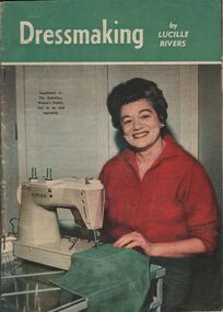
Magazine - AILEEN AND JOHN ELLISON COLLECTION: DRESSMAKING
... History House 11 Mackenzie Street Bendigo goldfields BOOKS Magazines Dressmaking Magazine: dressmaking by Lucille Rivers, supplement to the Australian Women's Weekly, not to be sold separately. ...Magazine: dressmaking by Lucille Rivers, supplement to the Australian Women's Weekly, not to be sold separately. On the cover a lady wearing a red cardigan sitting at a Singer sawing machine. The magazine has 48 pages.books, magazines, dressmaking -
 Bendigo Historical Society Inc.
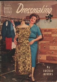
Magazine - AILEEN AND JOHN ELLISON COLLECTION: DRESSMAKING
... History House 11 Mackenzie Street Bendigo goldfields BOOKS Magazines Dressmaking Magazine: dressmaking by Lucille Rivers, supplement to the Australian Women's weekly, not to be sold separately. ...Magazine: dressmaking by Lucille Rivers, supplement to the Australian Women's weekly, not to be sold separately. On the cover a lady in blue dress standing with a mannequin displaying a gold and brown dress. The magazine has 48 pagesbooks, magazines, dressmaking -
 Bendigo Historical Society Inc.
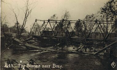
Postcard - ACC LOCK COLLECTION: THE SOMME NEAR BRAY, POSTCARD, 1914-1918
... History House 11 Mackenzie Street Bendigo goldfields POSTCARD WW1 River Somme Bray France bridge Postcard, WW1, B&W image of the River Somme near Bray showing a prefabricated steel bridge over the river with the remains of a wooden structure in the foreground. ...Postcard, WW1, B&W image of the River Somme near Bray showing a prefabricated steel bridge over the river with the remains of a wooden structure in the foreground. One copy number A43postcard, ww1, river somme, bray, france, bridge