Showing 11290 items matching "main roads"
-
 Mont De Lancey
Booklet, Department of Main Roads, Toll Roads and Bridges, 1981
... Department of Main Roads...Toll Roads and Bridges Booklet Department of Main Roads National Association of Australian State Road Authorities ...A brief history of tolls used throughout history, dating back around 1950 B.C. Early English and USA use is mentioned. Road and bridge tolls in Australia were collected for construction and maintenance of particular roads and bridges similar to their use in England. The clear photographs show the development in the this country up to 1981 when the brochure was published.A small slim rectangular paperback brochure with a lithograph of the "New Toll Gate" on Parramatta Road, published in J.G. Austin's Sydney Views. Green and white edging surrounds the picture with the title Toll Roads and Bridges printed in black lettering at the top right of the cover. On the back is a photograph of Toll cabins at the northern end of the Sydney Harbour Bridge showing automatic and manual toll booths with the symbol for NAASRA and National Association of Australian State Road Authorities printed in black and white at the bottom. Pp. 20. There are many photographs inside.non-fictionA brief history of tolls used throughout history, dating back around 1950 B.C. Early English and USA use is mentioned. Road and bridge tolls in Australia were collected for construction and maintenance of particular roads and bridges similar to their use in England. The clear photographs show the development in the this country up to 1981 when the brochure was published.road tolls, roads, bridges, history of tolls -
 Eltham District Historical Society Inc
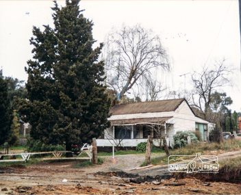
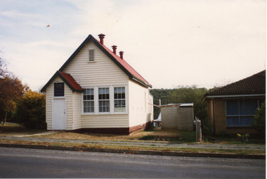
Photograph, Miner's Cottage, corner Main and Reynolds roads, Research, Vic, 1986
... Miner's Cottage, corner Main and Reynolds roads, Research, Vic.......main road...Miner's Cottage, owned by Mrs Ivy Reynolds at the corner of Main Road and Reynolds Road, Eltham. Wal and Bernie Dodkins, rented the house from around 1938 until they left in the 1970s to become caretakers at the Kangaroo Ground Tower. ...Three views show widening of Main Road....Three views show widening of Main Road. Miner's Cottage, corner Main and Reynolds roads, Research, Vic. ...Miner's Cottage, owned by Mrs Ivy Reynolds at the corner of Main Road and Reynolds Road, Eltham. Wal and Bernie Dodkins, rented the house from around 1938 until they left in the 1970s to become caretakers at the Kangaroo Ground Tower. Lyn Dodkins (wife of Graeme Hardiman) was born there and lived in this house for her first 19 years. [Graeme Hardiman email 5 Aug 2022] The site was developed for commercial use as the Eltham Motor Inn, which permanently closed about 2024 and has since been refurbished for use as rental units (2025).Six colour photographs of old cottage corner Main and Reynolds roads at Research in 1986. The cottage was built by/for Grandfather Reynolds and was demolished 2 Mar 1987. Three views show widening of Main Road.houses, main road, reynolds road, research (vic.), lyn dodkins, wal dodkins, bernie dodkins, miss reynolds, dodkins family, eltham, eltham motor inn, ivy reynolds, miner's cottage -
 Ringwood and District Historical Society
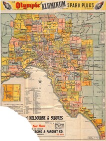
Map, Main Roads Map of Melbourne and Suburbs - c.1950
... Main Roads Map of Melbourne and Suburbs - c.1950...Insets include commercial advertising, information, and maps of Melbourne City Streets, Bayside Resorts, and Wharfs & Docks. Main Roads Map of Melbourne and Suburbs - c.1950 Map ...Partially damaged double-sided multi-fold poster-size flyer with Melbourne map showing Collins Street Directory 1950 page references. Railway lines include Inner Circle Line sections (closed 1981) and Outer Circle Line sections (closed 1945). Insets include commercial advertising, information, and maps of Melbourne City Streets, Bayside Resorts, and Wharfs & Docks.Collins Directory Maps compass rose logo. Folding instructions - "Note: Don't hold here to fold. Hold right hand edge and push towards left, so that centre crease rises and sheet closes concertina fashion." Map reference headings include Racecourses, Hospitals, Cemeteries, Parks & Gardens, Colleges, and General. -
 Linton and District Historical Society Inc
Leaflet, Grenville Standard Print, Linton, Duties and Responsibilities of Patrol Men
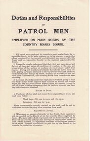
... Printed leaflet of four pages setting out working conditions of men employed on main roads by the Country Roads Board. Two copies....Text: " Duties and Responsibilities / OF / PATROL MEN / EMPLOYED ON MAIN ROADS BY THE / COUNTRY ROADS BOARD. "...Linton and District Historical Society Inc 69 Sussex Street Linton 3360 goldfields Country Roads Board Employment Text: " Duties and Responsibilities / OF / PATROL MEN / EMPLOYED ON MAIN ROADS BY THE / COUNTRY ROADS BOARD. " Printed leaflet of four pages setting out working conditions of men employed on main roads by the Country Roads Board. ...Printed leaflet of four pages setting out working conditions of men employed on main roads by the Country Roads Board. Two copies.Text: " Duties and Responsibilities / OF / PATROL MEN / EMPLOYED ON MAIN ROADS BY THE / COUNTRY ROADS BOARD. "country roads board, employment -
 City of Ballarat
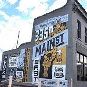
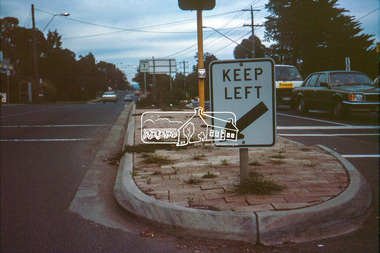
Artwork, other - Public Artwork, Travis Price, Main Road Mural by Travis Price, May 2018
... Main Road Mural by Travis Price...main road history...Main Road Mural tells the broader story of the history of Main Road in Ballarat. ...Painted mural on shop wall in Main Road, Ballarat...City of Ballarat The Phoenix 25 Armstrong Street South Ballarat goldfields Main Road Mural tells the broader story of the history of Main Road in Ballarat. ...Whilst my main focus for the artwork design was on the Hotels on Main Road, I felt there was an opportunity to tell a broader story of Main Rd and combine/include some interesting pieces of information from many stages of the history of Main Road. Considering that at one point in time there would have been at more than six hotels in this very short section of street….there’s no doubt Main Rd was an epicentre of communication and festivities for the Goldfields of Ballarat. “No matter what luck he had, every miner needed supplies, food and something to entertain him when he was not searching for gold.” Described as being an overcrowded jumble of muddy streets loosely arranged around mining camps...and loud, muddy, colourful and sometimes illicit. I wanted the artwork composition to consist of overlapping images and text to reflect this sense of hustle and bustle. Main Road Mural tells the broader story of the history of Main Road in Ballarat. In 2018, the City of Ballarat commissioned local Ballarat artist Travis Price to create an artwork to align with the Main Road Revitalisation Project and deliver a key component of the storytelling (heritage interpretation) project that spans the length of the shopping precinct. The artwork is featured on a prominent site in the shopping precinct of main road and tells the story of Main Road through depicting key timeline events. Main Road, as its name suggests, was one of the main entries to the mining areas of East Ballarat. It had several names: Main Street before 1858, Plank Road between 1858 and 1868 and Main Road from 1868 onwards. The centre of mining life, it was crowded, prosperous, raucous and dirty. Painted mural on shop wall in Main Road, BallaratBallaarat, Gold Fever, The Royal Standard Hotel, Flood, Boxing Saloon, Plank Road, Kulin Nation, 3350, Election, East, Grog House, The Scandinavian Hotel. Images; Chinese lantern, Pick & Shovel, Miners Licence burning.main road history, ballarat hotels, gold fever, wadawurrung, kulin nation -
 Sunshine and District Historical Society Incorporated
Photograph - Main Road West - Stevens' Farmhouse
... Main Road West - Stevens' Farmhouse...Main Road West...The Stevens' farm located on the north side of Boundary Road (Now Main Road West). The original farmhouse has been demolished....5661 - Main Road West - Stevens' Farmhouse.JPG...Many of the streets in the area of the old Stevens' farm are named after family members. Main Road West St. Albans Stevens 5661 - Main Road West - Stevens' Farmhouse.JPG Scanned image Photograph Main Road West - Stevens' Farmhouse ...The Stevens' farm located on the north side of Boundary Road (Now Main Road West). The original farmhouse has been demolished.Many of the streets in the area of the old Stevens' farm are named after family members.5661 - Main Road West - Stevens' Farmhouse.JPGmain road west, st. albans, stevens -
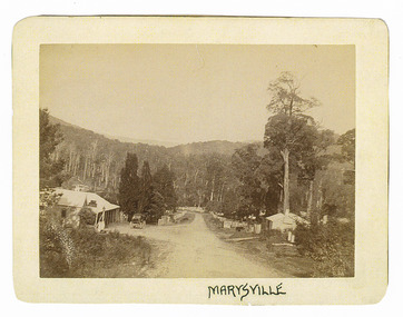
 Marysville & District Historical Society
Photograph (Item) - Black and white photograph, Unknown
... An early black and white photograph of the main road in Marysville in Victoria....An early black and white photograph of the main road in Marysville in Victoria....Marysville & District Historical Society 39 Darwin Street Marysville yarra-valley-and-the-dandenong-ranges An early black and white photograph of the main road in Marysville in Victoria. An early black and white photograph of the main road in Marysville in Victoria. ...An early black and white photograph of the main road in Marysville in Victoria.An early black and white photograph of the main road in Marysville in Victoria. This road is now known as Murchison Street.murchison street, marysville, victoria, photograph -
 Federation University Art Collection
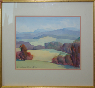
Painting - Watercolour, 'Towards Avoca' / 'Mount Buninyong in Autumn' by David Alexander, 1999
... One side is 'Towards Avoca' and the other side is 'Buninyong From Main Road, 24/04/1999'...David Alexander wrote on 'Buninyong From Main Road, 24/04/1999' "Wash wouldn't dry. People everywhere"...One side is 'Towards Avoca' and the other side is 'Buninyong From Main Road, 24/04/1999' 'Towards Avoca' / 'Mount Buninyong in Autumn' by David Alexander Painting Watercolour David Alexander ...This item is part of the Federation University Art Collection. The Art Collection features over 1000 works and was listed as a 'Ballarat Treasure' in 2007.Unframed double sided landscape artwork by David Alexander. One side is 'Towards Avoca' and the other side is 'Buninyong From Main Road, 24/04/1999'David Alexander wrote on 'Buninyong From Main Road, 24/04/1999' "Wash wouldn't dry. People everywhere"art, artwork, david alexander, alexander, buninyong, avoca, watercolour -
 Eltham District Historical Society Inc
Photograph, Main Road, Lower Plenty
... Main Road, Lower Plenty......main road...Date of photo is pre 1960s before duplication of Main Road....Black and white photograph of Main Road, Lower Plenty looking west from Old Eltham Road...Date of photo is pre 1960s before duplication of Main Road. lower plenty main road old eltham road Black and white photograph of Main Road, Lower Plenty looking west from Old Eltham Road Main Road, Lower Plenty Photograph ...View is from Old Eltham Road looking northwest across Main Road to the De Bondy property and family home. Date of photo is pre 1960s before duplication of Main Road.Black and white photograph of Main Road, Lower Plenty looking west from Old Eltham Roadlower plenty, main road, old eltham road -
 Whitehorse Historical Society Inc.
Map, Map of Mitcham, 1916?
... Showing main roads and large blocks of land with owners' names....Copy of early map of Mitcham showing main roads and large blocks of land with owners' names...Whitehorse Historical Society Inc. 2-10 Deep Creek Road Mitcham melbourne Showing main roads and large blocks of land with owners' names. ...Copy of early map of Mitcham.Copy of early map of Mitcham showing main roads and large blocks of land with owners' namesCopy of early map of Mitcham. mitcham road mitcham, heatherdale road mitcham, whitehorse road mitcham, morton, william, ainger, f, morgan, r. r., harding, w, sergeant, r, mcclelland, john, wilson, w, cook, j -
 Eltham District Historical Society Inc
Photograph, Construction of Lower Plenty Bridge, Main Road, c.August 1966, 1966
... Construction of Lower Plenty Bridge, Main Road, c.August 1966......main road...Construction activity of a new Main Road bridge over the Plenty River at Lower Plenty in 1966. ...Black and white photograph of construction of new bridge, Main Road, Lower Plenty...Construction activity of a new Main Road bridge over the Plenty River at Lower Plenty in 1966. ...Construction activity of a new Main Road bridge over the Plenty River at Lower Plenty in 1966. The new bridge followed a realignment of the road and old Lower Plenty bridge remained in situ and is now part of the Plenty River Trail.Black and white photograph of construction of new bridge, Main Road, Lower Plentybridge construction, main road, lower plenty, plenty river, bridges -
 Greensborough Historical Society
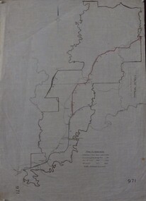
Maps, Shire of Heidelberg, 1920s
... Map of main roads within Shire of Heidelberg, probably those for which the Shire was responsible for maintaining...Map of main roads within Shire of Heidelberg, hand coloured, and Hurstbridge rail line. 40 chains: 1 inch...Greensborough Historical Society 34A Glenauburn Road Lower Plenty Lower Plenty melbourne Map of main roads within Shire of Heidelberg, probably those for which the Shire was responsible for maintaining shire of heidelberg heidelberg 971 Map of main roads within Shire of Heidelberg, hand coloured, and Hurstbridge rail line. 40 chains: 1 inch Shire of Heidelberg Maps Shire of Heidelberg ...Map of main roads within Shire of Heidelberg, probably those for which the Shire was responsible for maintainingMap of main roads within Shire of Heidelberg, hand coloured, and Hurstbridge rail line. 40 chains: 1 inch971shire of heidelberg, heidelberg -
 Bendigo Historical Society Inc.
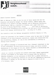
Document - LONG GULLY HISTORY GROUP COLLECTION: NEIGHBOURHOOD WATCH
... ... Department of Main Roads...The third, dated 30/5/97, also mentions Eaglehawk Heritage Society, Cornish Miners, Cornish Association, Long Gully School, Department of Main Roads, St laurence Court, Charles Fay, La Trobe History Department. ...The third, dated 30/5/97, also mentions Eaglehawk Heritage Society, Cornish Miners, Cornish Association, Long Gully School, Department of Main Roads, St laurence Court, Charles Fay, La Trobe History Department. ...BHS CollectionThree pages, the first titled Neighbourhood Watch. The second, dated 2/6/97, mentions a phone call to the City of Greater Bendigo about speaking to Marco in the Planning Department. The third, dated 30/5/97, also mentions Eaglehawk Heritage Society, Cornish Miners, Cornish Association, Long Gully School, Department of Main Roads, St laurence Court, Charles Fay, La Trobe History Department. It has Cheryl Wallis signature at the bottom of page.bendigo, history, long gully history group, the long gully history group - neighbourhood watch, edward clarence dyason, isaac dyason, george lansell, st andrew's college, melbourne university, bendigo amalgamated goldfield company, chamber of mines, gold producers association, bendigo mines limited, league of nations, australian institute for international affairs, melbourne syphony orchestra, world war ii, british commonwealth relations conference, powercor australia, city of greater bendigo, eaglehawk heritage society, cornish association, long gully school, department of main roads, st laurence court, charles fay, la trobe history department, cheryl wallis -
 Ballarat Heritage Services
Photograph, Bellinzona House, 1900, 1900
... He named his house on the corner of Main road and Seventh St in Hepburn Springs "Bellinzona". ...A weatherboard house in the Main Road of Hepburn Springs, run by the Misses Borsa. ...He named his house on the corner of Main road and Seventh St in Hepburn Springs "Bellinzona". ...Battista Borsa was from Bellinzona in Ticino, Switzerland. He named his house on the corner of Main road and Seventh St in Hepburn Springs "Bellinzona". His daughters ran the house as a guest house in 1900. This house was burnt down in the 1906 Bushfire. it was rebuilt in Edwardian tradition, and was again burnt down and rebuilt on a much larger footprint. A weatherboard house in the Main Road of Hepburn Springs, run by the Misses Borsa. borsa, bellinzona, boarding house, hepburn springs -
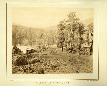 Marysville & District Historical Society
Photograph (Item) - Black and white photograph, Nicholas John Caire, Views of Victoria, Unknown
... An early black and white photograph of the main road in Marysville in Victoria taken by Nicholas John Caire....An early black and white photograph of the main road in Marysville in Victoria taken by Nicholas John Caire. ...CAIRE, PHOTOGRAPHER ROYAL ARCADE, MELBOURNE An early black and white photograph of the main road in Marysville in Victoria taken by Nicholas John Caire. ...An early black and white photograph of the main road in Marysville in Victoria taken by Nicholas John Caire.An early black and white photograph of the main road in Marysville in Victoria showing the Keppels Australian Hotel which was built and opened by the Keppel Family in 1865. The Keppels Australian Hotel was the first hotel to be opened in Marysville. The Keppel Family were among Marysville's earliest pioneering families. This photograph was taken by Nicholas John Caire. N.J. Caire had a great love for the area in and surrounding Marysville and in the late 1800's took many photographs of Marysville and its surrounds. N.J. Caire was born in 1837 in Guernsey. He arrived in Adelaide about 1860 along with his parents who encouraged his early interest in photography. He opened a studio in Adelaide in 1867 after traveling extensively throughout the Gippsland taking photographs. After marrying in 1870 he moved to Talbot in Victoria until 1876 when he opened a studio in the Royal Arcade in Melbourne. After 1885 N.J. Caire gave up his city work and made his home in South Yarra and devoted the rest of his life to outdoor photography, specializing in the bush, the gullies and the mountains of south-eastern Victoria. N.J. CAIRE, PHOTOGRAPHER ROYAL ARCADE, MELBOURNEmarysville, victoria, keppels australian hotel, keppel family, nicholas john caire, photograph -
 Eltham District Historical Society Inc
Slide - Photograph, Main Road at Bridge Street, Eltham, c.May 1988
... Main Road at Bridge Street, Eltham......Main Road...Main Road at Bridge Street, Eltham, c.May 1988...Eltham District Historical Society Inc 728 Main Rd Eltham melbourne Main Road at Bridge Street, Eltham, c.May 1988 Bridge Street Eltham Infrastructure Main Road Roads Process Date MAY 88M 35mm colour positive transparency (1 of 36) Mount - Kodak Kodachrome Main Road at Bridge Street, Eltham Slide Photograph ...Main Road at Bridge Street, Eltham, c.May 198835mm colour positive transparency (1 of 36) Mount - Kodak KodachromeProcess Date MAY 88Mbridge street, eltham, infrastructure, main road, roads -
 Emerald Museum & Nobelius Heritage Park
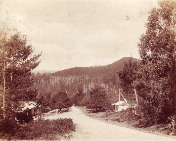
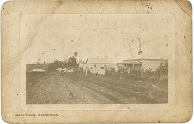
Postcard - Postcard of 'Main Road - Gembrook'
... Postcard of 'Main Road - Gembrook'...Sepia postcard with rounded corners featuring photograph of unmade Main Road in Gembrook. The Ranges Hotel which opened in 1902 is just visible on the left. ...On front at bottom, printed: 'MAIN ROAD - GEMBROOK' On back printed at the top: 'POST CARD' Underneath that is printed: 'SPACE FOR CORRESPONDENCE' and 'SPACE FOR ADDRESS' On back is handwritten message: 'J Brooks / 16 notts Sawmills / well fixed / Gembrook'...Postcard Postcard of 'Main Road - Gembrook' ...Many sawmills operated in Gembrook in the forest to the east from early colonial settlement days. The opening of the narrow-gauge train line in 1900 assisted the expansion of this industry. This postcard is circa 1900s. This and other postcards and photos came from the estate of David Moyle (1938-2015) who was a police officer in Emerald during late 1960s-early 1970s, and subsequently at Belgrave in the early 1980s. David Moyle was closely associated with the now defunct Sherbrooke Historical Association.This postcard is significant because of its evocation of Gembrook's early timber industry. it is also part of a collection belonging to a community member who had a close association with a local historical society.Sepia postcard with rounded corners featuring photograph of unmade Main Road in Gembrook. The Ranges Hotel which opened in 1902 is just visible on the left. The view is towards the west.On front at bottom, printed: 'MAIN ROAD - GEMBROOK' On back printed at the top: 'POST CARD' Underneath that is printed: 'SPACE FOR CORRESPONDENCE' and 'SPACE FOR ADDRESS' On back is handwritten message: 'J Brooks / 16 notts Sawmills / well fixed / Gembrook'david moyle, police, emerald, belgrave, timber mills, gembrook, brooks, 1900s -
 Mt Dandenong & District Historical Society Inc.
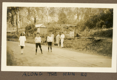
Photograph
... ...Main Road...The road featured called the 'Main Road' is what we know know as Mt Dandenong Tourist Road. ...Handwritten below the photograph in the album: ALONG THE MAIN ROAD...The road featured called the 'Main Road' is what we know know as Mt Dandenong Tourist Road. ...The photograph is from the album of Ivy Child. The road featured called the 'Main Road' is what we know know as Mt Dandenong Tourist Road. It has been made but not tarred. The identity of the people is unknown. Ivy May Child (1910 – 1989) was the daughter of Arthur Edward (Ted) Child (1878 – 1964) and Ethel May Madden (1888 – 1970). Ted Child was the son of Matthew Francis Child (1839 – 1933) and Martha Jeeves (1857 – 1926). He was the grandson of one of the early pioneers Francis Child. Ivy grew up on the family property on Childs Road and took many photographs. Most of these are glued into her photo album. The album covered the years from c1927 – 1932. Ivy married Henry William Burgess (1906 – 1968) in 1944. The photographs remain in their original state in the album with individual copies made. Sepia coloured photograph showing a stretch of road with two young boys and a girl standing in the middle. Behind them, standing on the edge of the road are two women and a man. Behind them is a wire and post fence with wooden gate and a shed. Bush is visible in the background.Handwritten below the photograph in the album: ALONG THE MAIN ROADivy child, main road, mt dandenong tourist road, tourist road, kalorama -
 Eltham District Historical Society Inc
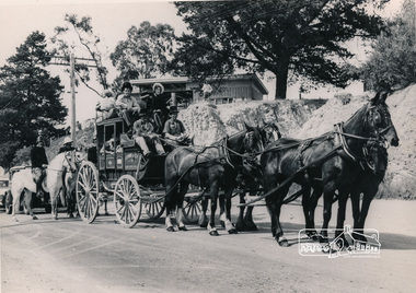
Photograph, Cobb and Co. Coach and horses, ERSILAC Parade, c.1960
... ...Main Road...Near the corner of Main Road and Bridge Street...Taken near the corner of Main Road and Bridge Street. Part of a procession/parade....Taken near the corner of Main Road and Bridge Street. Part of a procession/parade. ...Near the corner of Main Road and Bridge StreetBlack and white photograph featuring a Cobb and Co coach drawn by four horses with a full complement of passengers in period clothing. Taken near the corner of Main Road and Bridge Street. Part of a procession/parade.cobb and co, bridge street, ersilac parade, horse drawn carriage, main road -
 Eltham District Historical Society Inc
Photograph, Bryant Motors, Eltham, c.1969
... ...main road...The image was most likely taken shortly after duplication of Main Road....Black and white photograph of Bryant Motors and Bus Depot, Main Road, Eltham opposite Luck Street, c.1960....The image was most likely taken shortly after duplication of Main Road. bryant motors main road eltham bus depot Diamond Valley Coaches Main Road Eltham Eltham Railway Station Rough drawing of building with dimensions Black and white photograph of Bryant Motors and Bus Depot, Main Road, Eltham opposite Luck Street, c.1960. ...Bryant Motos and Diamond Valley Coaches was located just north of the Station Masters house where the present-day railway station car park is opposite Pryor to Luck Street. The image was most likely taken shortly after duplication of Main Road.Black and white photograph of Bryant Motors and Bus Depot, Main Road, Eltham opposite Luck Street, c.1960.Rough drawing of building with dimensionsbryant motors, main road, eltham, bus depot, diamond valley coaches, main road eltham, eltham railway station -
 Ballarat Tramway Museum
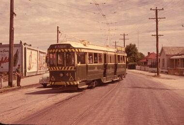
Slide - 35mm slide/s, Wal Jack, 4/11/1961 12:00:00 AM
... Photo of Ballarat No. 41, derailed in Barkly St. Ballarat near main road on 4-11-1961. Image is going red. ...'SEC Ballarat No. 41 derailed in Barkly St. near Main Road, 4-11-61 1.40pm' in blue ink....Ballarat near main road on 4-11-1961. Image is going red. Tram fitted with dash canopy lights, small white stripe, large triangles. ...Photo of Ballarat No. 41, derailed in Barkly St. Ballarat near main road on 4-11-1961. Image is going red. Tram fitted with dash canopy lights, small white stripe, large triangles. Penfold Sherry ad on roof. Numerous markings on road surface of previous? derailments. Note advertisement hoardings in background of photo, one featuring an ad for Penfolds. Tram has a destination of 'Mt. Pleasant.''SEC Ballarat No. 41 derailed in Barkly St. near Main Road, 4-11-61 1.40pm' in blue ink.tramways, trams, barkly st., derailments, accidents, mt. pleasant, tram 41 -
Eltham District Historical Society Inc
Document - Folder, Shortte, Jim
... ...Main Roads Department...Jim Shortte was a Supervisor with the Main Roads Department, living with wife Avalon at 6 Kanada Court Research. ...Eltham District Historical Society Inc 728 Main Rd Eltham melbourne Jim Shortte was a Supervisor with the Main Roads Department, living with wife Avalon at 6 Kanada Court Research. ...Jim Shortte was a Supervisor with the Main Roads Department, living with wife Avalon at 6 Kanada Court Research. Contents Photocopy letter, Jim Shortte to Avalon Shortte, 15 January 1967. Photocopy letter, Jim Shortte to Avalon Shortte, 28 February 1967. Two photographs of Jim Shortte: one as a young man formally dressed holding sulphur-crested cockatoo; one in middle-age wearing a suit. Letter Sharon Okey to Eltham District Historical Society, 29 September 2008, enclosing material about Jim Shortte, her great uncle [mentions enclosing 2 diaries; however, not in collection].Newspaper clippings, A4 photocopies, etcjim shortte, avalon shortte nee munro, 8 kananda court research, 6 kanada court research, main roads department -
 Eltham District Historical Society Inc
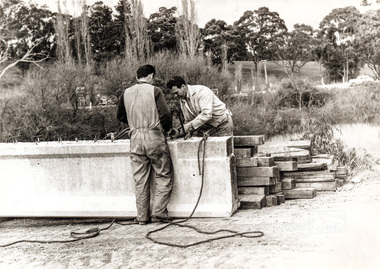
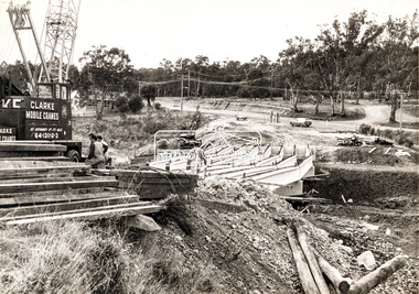
Photograph, Construction of new bridge over the Plenty River, Main Road, Lower Plenty, 13 July 1966
... Construction of new bridge over the Plenty River, Main Road, Lower Plenty......Main Road...Construction activity of a new Main Road bridge over the Plenty River at Lower Plenty in 1966. ...Marking on back of photograph - Plenty River Bridge Main Road 1969 (sic)...Construction activity of a new Main Road bridge over the Plenty River at Lower Plenty in 1966. ...Construction activity of a new Main Road bridge over the Plenty River at Lower Plenty in 1966. The new bridge followed a realignment of the road and old Lower Plenty bridge remained in situ and is now part of the Plenty River Trail. Includes structural members, construction personnel, vehicles and a Clarke mobile crane. Published Diamind Valley News, Tuesday, July 19, 1966, p1 Piecing Bridge Together A tall crane was used last Wednesday to lift and place in position the concrete and steel girders for the sub-structure of the new Lower Plenty Bridge. The picture shows the girders in position, looking towards the approach on the Lower Plenty side.Local significanceBlack and white printMarking on back of photograph - Plenty River Bridge Main Road 1969 (sic)lower plenty, main road, plenty river, bridge, bridge construction, civil engineering, cranes, mobile cranes -
 Ballarat Heritage Services
Photograph - Photograph - Colour, Clare Gervasoni, Former Yandoit Hills School 2052 after being moved to Hepburn Springs, c2005, c2005
... This building was moved from Yandoit Creek to the corner of Main Road and Seventh Street, Hepburn Springs. ...Colour photograph of on old schoolhouse that was moved from Yandoit Hills to the corner of Main Road and Seventh Street, Hepburn Springs. ...Main Road, Hepburn Springs, Victoria, Australia...Ballarat Heritage Services PO Box 2209 Bakery Hill Post Office goldfields This building was moved from Yandoit Creek to the corner of Main Road and Seventh Street, Hepburn Springs. ...This building was moved from Yandoit Creek to the corner of Main Road and Seventh Street, Hepburn Springs. Colour photograph of on old schoolhouse that was moved from Yandoit Hills to the corner of Main Road and Seventh Street, Hepburn Springs. The building was used for religious services before being turned into a private residence. yandoit hills state school no 2052, education, hepburn springs, yandoit hills, yandoit creek -
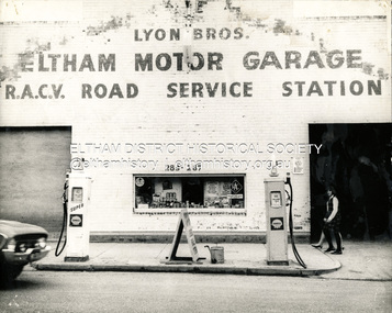 Eltham District Historical Society Inc
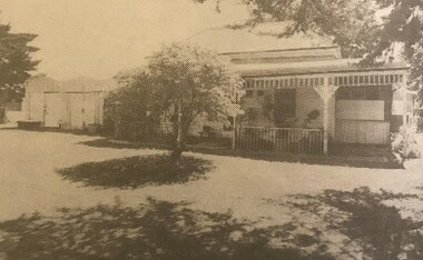
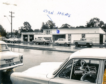
Photograph, George W. Bell, Lyon Bros. Eltham Motor Garage, 283-287 Main Road, Eltham, c.1964
... Eltham Motor Garage, 283-287 Main Road, Eltham......Main Road Eltham...John Lyon used to live on the comer of Bridge Street and Main Road on top of the cliff. He was later killed in an accident at Rosanna railway crossing 29th Feb, 1960 [Source: Doug Orford]. ...Eltham Motor Garage 283-287 Main Road Eltham c.1960...Eltham Motor Garage 283-287 Main Road Eltham c.1960 Lyon Bros. Eltham Motor Garage, 283-287 Main Road, Eltham Photograph George W. ...Lyon Bros Eltham Motor Garage originally opened as an old tin shed garage in 1923 alongside Dave Lyon’s weatherboard home, a Californian bungalow at present-day 856 Main Road, Eltham in the dip between York and Henry Streets - there was a wood yard and garage at the back. That house remains standing today (2026). It later became a Chiropractor’s practice now operating as Eltham Cosmetic Clinic. Earliest advertisements for the business date from March 1923 – advertise that they have opened a motor garage near the post office, where a car or petrol may be procured day or night, and repairs effected. (The Advertiser, 2 March 1923) Between May 1942 and December 1945 [based on a newspaper article "Eltham Killed in Brownout" (1942, May 15). Eltham and Whittlesea Shires Advertiser (Vic. : 1940 - 1942), p. 3. Retrieved May 23, 2026, from http://nla.gov.au/nla.news-article57496549 and aerial photos taken in December 1945], the brothers relocated the business to 283-287 Main Road Eltham, opposite Arthur Street. The garage was an official RACV Road Service Station and offered vehicles for hire in addition to conducting repairs. It was also an Agent for Shell petrol. During the war Dave was working in the garage one night with a motor running. He was almost unconscious, and Jack Burgoyne happened to stop off with his truck and went and dragged him out. John Lyon used to live on the comer of Bridge Street and Main Road on top of the cliff. He was later killed in an accident at Rosanna railway crossing 29th Feb, 1960 [Source: Doug Orford]. This photo is dated circa 1964 and the address is clearly 283-287 Main Road however by 1971 street numbers had been revised to present-day numbering and by the time the site had been redeveloped as Lyon Bros. Ford the address was 953 Main Road. Just featured is an XL Falcon manufactured 1962-1964 Community memories after posting this photo on Facebook include: "I can remember my dad putting 2 shilling pieces into a bowser to get petrol after hours." A similar photo is featured in the Shire of Eltham Pioneers Photograph Collection, SEPP_0664Black and white photograph of Lyon Bros. Eltham Motor Garage 283-287 Main Road Eltham c.1960953 main road eltham, 1963, automobiles, businesses, eltham, eltham motor garage, ford xl falcon, george w. bell collection, lyon, lyon bros. garage, main road eltham, racv road service station, shell service station -
 Eltham District Historical Society Inc
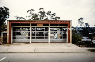
Photograph, Eltham Fire Station, 909 Main Road, Eltham, July 1986
... Eltham Fire Station, 909 Main Road, Eltham......Main Road Eltham...Browne and Ryan Bros. butchers on the eastern side of Main Road between Arthur and Dudley streets. ...Colour photograph of Eltham Fire Station, Main Road, July 1986...eltham fire brigade Eltham Fire Station Eltham Shops Main Road Eltham Colour photograph of Eltham Fire Station, Main Road, July 1986 Eltham Fire Station, 909 Main Road, Eltham Photograph ...Located at 909 Main Road, Eltham. Opened 7 October 1966 Eltham's Fire Stations by Peter Pidgeon Article published EDHS Newsletter No.287 April 2026 Where was Eltham’s first fire station and how many have there been? Following the formation of the Eltham Volunteer Fire Brigade in March 1926, firefighting equipment was initially housed in a shed on Captain H. Warren’s property. A more permanent solution was required. In May 1927 a proposal was made to build a fire station and meeting hall at the corner of Luck Street and Main Road where the present railway station carpark is located. An application was approved by Council in September to build the fire station consisting of a galvanised iron shed on the land in Luck Street, However, in April 1928 when E.O. Egan, Secretary, Eltham Volunteer Fire Brigade sought permission to erect a fire station on the continuation of Luck Street, Council advised they had no power to act on this as they did not own the land. Cr. Ernie Andrew offered to loan a site on his own land in Arthur Street (where the entrance to the carpark under Woolworths is situated) and by September 1928 the new fire station was being erected consisting of a building to house the reel and other equipment as well as a meeting room. It was constructed with a concrete floor and painted. A purpose-built cupboard had been constructed for the hose by local carpenter, Mr. Fraser and Mr. Frank Jones arranged for electric lighting to be installed. Many donations were made by the community to assist in paying off the debt on the station. The first meeting in the new fire station was held November 12, 1928, with a large attendance of members. The official opening was to be held in the New Year on January 8, 1929. In February 1930, Eltham Council agreed to place the Eltham Volunteer Fire Brigade under the control of the Country Fire Brigades’ Board. Further discussions were held in May regarding their area of responsibility to cover as well as questions about a suitable block of land and relocation of the brigade’s buildings. In August 1930, the Chief Officer of Country Fire Board visited Council to select a suitable site. He did not approve of any that Council suggested but encouraged Council to buy land for the purpose. Enquiries were made about a block in Henry Street adjacent to the Public Hall which the Chief Officer favoured. Cr Price investigated and learned the block could be purchased, £10 would secure it if the people of Eltham were willing to raise a further £30-40. All were in favour of proceeding. By February 1931, £40 had been raised by the community, in addition to £20 added by Council and £20 by the Fire Brigades’ Board making £80 total to purchase the site. Several working bees were held between May and July 1931 to level the ground in preparation for relocation of the station building from Arthur Street to the new site in Henry Street. It was not long before the Henry Street site had proven to be not all that was desired. Access to the Henry Street site from Main Road was steep and not suited for man handling a heavy hose reel. By November 1933 the Country Fire Brigades’ Board advised it was considering the matter of a new cation and fire station for Eltham. On February 23, 1934, the Advertiser reported a new Fire Station was to be built on an alternate site at a cost of £600. In August, the Country Fire Brigades’ Board notified it intended to build a new fire station at no cost to Eltham if the brigade could purchase a block of land. An appeal was established by the brigade to raise funds for the purchase of the new site between the residence and confectionery shop owned by Mr. G.H. Browne and Ryan Bros. butchers on the eastern side of Main Road between Arthur and Dudley streets. An inspection of the site by the Chief Officer of Country Fire Brigades' Board was undertaken September 28. It was directed that tenders for the erection of the building were to be called immediately and construction to start the next month. By New Year 1935 the erection of the third station building was well in progress and was completed by mid-February. The station was officially opened April 26, 1935, and a new 35 feet high bell tower was erected in December 1935. This fire station, the third erected in six years, served the community for the next thirty years. In 1962, land for a new (fourth) Eltham Fire Station on the opposite (western) side of Main Road was acquired from the Eltham War Memorial Trust. The new station was opened October 7, 1966. In 1970 the former fire station building on the eastern side of Main Road was relocated to Research Park for use by the 1st Research Scout group. The site is now part of the current Coles supermarket and Eltham Village complex. A new fifth fire station was erected in Brougham Street at a cost of $9.6m and officially opened December 2015. It was intended for use by both career and volunteer firefighters. The former site was to be made available for community access. However, the mixed functional role presented operational difficulties at the new station and after three years, the Eltham CFA volunteers moved back to the former site towards the end of 2018 following a $500,000 upgrade to the facility. So nowadays the career Fire Rescue Victoria members of Eltham Fire Brigade operate out of Eltham’s fifth fire station in Brougham Street and the volunteer Eltham CFA Brigade operate out of Eltham’s fourth station, or could it be considered the sixth?Colour photograph of Eltham Fire Station, Main Road, July 1986eltham fire brigade, eltham fire station, eltham shops, main road eltham -
 Eltham District Historical Society Inc
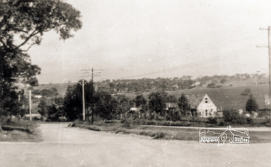
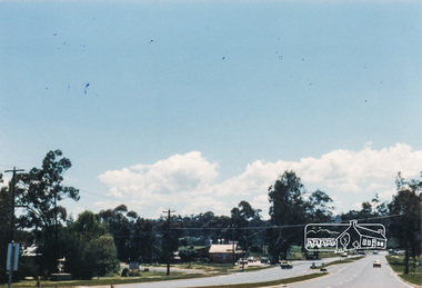
Photograph, M. North, Main Road, Eltham near Fitzsimons Lane Roundabout, Dec 1985, 1/12/85
... Main Road, Eltham near Fitzsimons Lane Roundabout, Dec 1985...main road...Two colour photographs of Main Road, ElthamSouth between Falkiner Street and Bolton Street at the roundabout of Fitzsimons Lane, Eltham, Dec 1985...Old Eltham Park on right of photo The two shops at left (Ansel and Muir) Road ahead crosses new bridge over the Diamond Creek, Eltham Main Road now dual highway, through Lower Plenty to this bridge'...Old Eltham Park on right of photo The two shops at left (Ansel and Muir) Road ahead crosses new bridge over the Diamond Creek, Eltham Main Road now dual highway, through Lower Plenty to this bridge' Two colour photographs of Main Road, ElthamSouth between Falkiner Street and Bolton Street at the roundabout of Fitzsimons Lane, Eltham, Dec 1985 Main Road, Eltham near Fitzsimons Lane Roundabout, Dec 1985 Photograph M. ...Two colour photographs of Main Road, ElthamSouth between Falkiner Street and Bolton Street at the roundabout of Fitzsimons Lane, Eltham, Dec 1985Noted on 463B 'See 1934 small black and white snap of flooded bridge and the same two shops. This snap taken from same location, Dec 1985. Old Eltham Park on right of photo The two shops at left (Ansel and Muir) Road ahead crosses new bridge over the Diamond Creek, Eltham Main Road now dual highway, through Lower Plenty to this bridge'main road, eltham, eltham south, fitzsimons lane, round about, falkiner street -
 Marysville & District Historical Society
Photograph (Item) - Black and white photograph, Marysville, c1900
... An early black and white photograph of the main road in Marysville in Victoria showing the Keppels Australian Hotel....An early black and white photograph of the main road in Marysville in Victoria. In the left hand side of the image can be seen the Keppels Australian Hotel with a horse-drawn coach standing outside. ...An early black and white photograph of the main road in Marysville in Victoria showing the Keppels Australian Hotel which was built and opened by the Keppel Family in 1865. ...An early black and white photograph of the main road in Marysville in Victoria showing the Keppels Australian Hotel.An early black and white photograph of the main road in Marysville in Victoria showing the Keppels Australian Hotel which was built and opened by the Keppel Family in 1865. The Keppels Australian Hotel was the first hotel to be opened in Marysville. The Keppel Family were among Marysville's earliest pioneering families.ARMSTRONG COLLECTION 42 STATION STREET/ SANDRINGHAM 3191/ TEL. (03) 9521 5442/ IAN M.L. ARMSTRONG OAMaustralian hotel, marysville, keppel family, maurice john keppel, keppels australian hotel, keppels hotel, victoria -
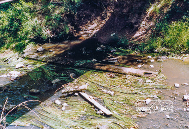 Eltham District Historical Society Inc
Photograph, Cross beam from old timber Main Road bridge over the Diamond Creek, 1992, 1992
... Cross beam from old timber Main Road bridge over the Diamond Creek, 1992......main road...Old cross beam from original Main Road trestle bridge washed away in 1924 flood lying in creek bed. ...Two colour photographs of old cross beam from original Main Road trestle bridge lying in creek bed. ...Unlikely to be present in 2026. bridges diamond creek main road eltham south Two colour photographs of old cross beam from original Main Road trestle bridge lying in creek bed. ...Old cross beam from original Main Road trestle bridge washed away in 1924 flood lying in creek bed. It is downstream from the current re-structured bridge at time of photo. Unlikely to be present in 2026.Two colour photographs of old cross beam from original Main Road trestle bridge lying in creek bed. It is downstream from the current re-structured bridgebridges, diamond creek, main road, eltham south -
Whitehorse Historical Society Inc.
Map, This is Vermont, 1895-1920?
... Hand-drawn map of Vermont from Springvale Road to Heatherdale Road, showing the names of owners of houses, main roads and streets, shops and schools....'Now you have seen it, tell your friends' - hand-drawn map of Vermont from Springvale Road to Heatherdale Road, showing the names of owners of houses, main roads and streets, shops and schools....Whitehorse Historical Society Inc. 2-10 Deep Creek Road Mitcham melbourne Hand-drawn map of Vermont from Springvale Road to Heatherdale Road, showing the names of owners of houses, main roads and streets, shops and schools. Vermont South Vermont Roads and streets 'Now you have seen it, tell your friends' 'Now you have seen it, tell your friends' - hand-drawn map of Vermont from Springvale Road to Heatherdale Road, showing the names of owners of houses, main roads and streets, shops and schools. ...'Now you have seen it, tell your friends''Now you have seen it, tell your friends' - hand-drawn map of Vermont from Springvale Road to Heatherdale Road, showing the names of owners of houses, main roads and streets, shops and schools.'Now you have seen it, tell your friends' vermont south, vermont, roads and streets