Showing 6 items matching "mallee (vic.)"
-
 Narre Warren and District Family History Group
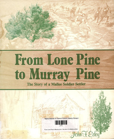
Book, John F Edey, From Lone Pine to Murray pine : the story of a Mallee soldier settler, 1981
... ...Mallee (Vic.)...Narre Warren and District Family History Group 110 High Street Berwick melbourne John Frederick Edey Mallee (Vic.) soldier settlement Autobiography of a First World War veteran ; includes account of trip made to Central Australia in 1927-28 and the author's encounters with and impressions of Aboriginal people. ...Autobiography of a First World War veteran ; includes account of trip made to Central Australia in 1927-28 and the author's encounters with and impressions of Aboriginal people.non-fictionAutobiography of a First World War veteran ; includes account of trip made to Central Australia in 1927-28 and the author's encounters with and impressions of Aboriginal people. john frederick edey, mallee (vic.), soldier settlement -
 Bendigo Historical Society Inc.
Map - Whipstick Southern Section, Unknown
... mallee. The park comes alive with native wildflowers in Spring, and is home to an array of wildlife including Swift Parrots and other bushland birds. Parks Vic...mallee. The park comes alive with native wildflowers in Spring, and is home to an array of wildlife including Swift Parrots and other bushland birds. Parks Vic ...The Whipstick forest is now part of the Greater Bendigo National Park. During the goldrush era it was heavily mined with many remnants of the former mines evident. The park protects an area of high-quality Box-Ironbark forest, as well as broombush mallee, grassy woodlands and Kamarooka mallee. The park comes alive with native wildflowers in Spring, and is home to an array of wildlife including Swift Parrots and other bushland birds. Parks Vic: https://www.parks.vic.gov.au/places-to-see/parks/Greater-Bendigo-National-Park Photocopy of maps: 1. 'The Whipstick Forest Park, southern section'. Map shows gullies - Beezlebub, Napoleon, Whitehorse, Opossum, Wellington, Red Jacket, Blackhorse, and Centipede. Mine sites and other significant features are marked including the Whipstick Diggings Settlement near Shadbolt Reserve. Mine sites are identified. 2. Huntly map showing allotments and gullies - Snowball Gully, Deadhorse Gully Nuggety Gully, and Scotchmans Gully are printed in large text on the map. whipstick forest, whipstick, gullies, gold mining, gold -
 Otway Districts Historical Society
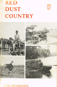
Book, Neptune Press Pty Ltd, Red Dust Country. G.M. Henriksen, 1984
... mallee; 1. Signed by the author on the title page. 2. "To Ben, from Glad H, with best wishes." Red Dust Country. G.M. Henriksen. 1st ed. Newtown (Vic ...Red Dust Country. G.M. Henriksen. 1st ed. Newtown (Vic.); Neptune Press; 1984. 184 p.; illus. Soft cover. ISBN 0 949583 37 51. Signed by the author on the title page. 2. "To Ben, from Glad H, with best wishes."red dust; g.m. henriksen; otways; wyelangta; mallee; -
 Marysville & District Historical Society
Book, Education Department of Victoria, Vision and Realisation-A Centenary History of State Education in Victoria-Volume 2, 1973
... Marysville & District Historical Society 39 Darwin Street Marysville yarra-valley-and-the-dandenong-ranges Histories of schools in the regions of Glenelg, Wimmera, Mallee, Loddon, Central Highlands, Corangamite and Barwon. education state education victoria history glenelg wimmera mallee loddon central highlands corangamite barwon A centenary history of state education in Victoria Label / Presented to / Council of Adult Education / LIBRARY / by VIC EDUCATION DEPARTMENT Stamp / CAE / LIBRARY / Class No. 379.945 / VIC / Acc. ...A centenary history of state education in VictoriaRed cover with the title and volume written on the spine in gold lettering. Both front and back inside covers have a photograph of 'The school at Drummond North' Photo: Geoff Maugernon-fictionA centenary history of state education in Victoriaeducation, state education, victoria, history, glenelg, wimmera, mallee, loddon, central highlands, corangamite, barwon -
University of Melbourne, Burnley Campus Archives
Journal, Department of Agriculture, Mallee Horticultural Digest, 1965
... Vic. Dept. of Agriculture , Vol. 12, No. 1, 1965 Mallee Horticultural Digest Journal Department of Agriculture ...Journal issued by Vic. Dept. of Agriculture , Vol. 12, No. 1, 1965department of agriculture -
Koorie Heritage Trust
Document - Printed Sheets, Beauglehole, A . C, The distribution and conservation of native vascular plants in the Victorian Mallee, 1979
... The distribution and conservation of native vascular plants in the Victorian Mallee Document Printed Sheets Beauglehole, A . C. Portland, Vic. : Western Victorian Field Naturalists Clubs Association ...ii, 99 p. : ill., map (fold.col.in pocket) ; 21x30 cm.indigenous vascular plants. distribution. victoria. mallee region. | botany -- victoria -- mallee.