Showing 112 items matching "map - gold mines in victoria"
-
 Federation University Historical Collection
Map - Plan, Ballarat Deep Leads and Mines, 1992, 1992
... Map - Gold Mines...Map - Gold Mines in Victoria...Gold Deposits in Victoria. Map No.6 Ballarat Sheet 1 of 2 The map shows geology, topography and information on mines in the following areas: one large map of the Ballarat area with five enlargements for: Sago Hill District; Scarsdale District; Pitfield Plains District; Berringa Gold Field and Rokewood District. ...Very large rectangular sheet of paper with seven coloured maps of various sizes and a small green rectangle on the bottom rhs with a map of Victoria superimposed over a poppet head. this rectangle includes information of the other maps shown. The background for these maps is white. Also includes tables of names of mine companies, name of shafts and gold... Mines of Australia Gold mines of Victoria Gold mines- Ballarat and District Gold Mines Pitfield Plains District Gold Mines Scarsdale District Gold Mines Berringa Gold Field Gold Mines Rokewood District Gold Mines Sago Hill District Map - Gold Mines Map - Gold Mines in Victoria Ballarat Pitfield Scarsdale Berringa Rokewood Sago Hill Deep Lead Gold Deposits in Victoria Geological Survey - Gold Deposits in Victoria mining gold deposits in Victoria Gold Mines in Victoria Rokewook Pitfield Plains Very large rectangular sheet of paper with seven coloured maps of various sizes and a small green rectangle on the bottom rhs with a map of Victoria superimposed over a poppet head. this rectangle includes information of the other maps shown. ...This is Bulletin No. 62: Deep Lead Gold Deposits in Victoria. Map No.6 Ballarat Sheet 1 of 2 The map shows geology, topography and information on mines in the following areas: one large map of the Ballarat area with five enlargements for: Sago Hill District; Scarsdale District; Pitfield Plains District; Berringa Gold Field and Rokewood District. Ballarat Mines and Deep Leads Report No.94 (Finlay and Douglas,1992) provides a summary of the Geological Survey of Victoria mines database, references and geology for most of the mines on this map. Geology Compilation: simplified from earlier Departmental mapping with minor field checking by E.N.M. Plier-Malone. Very large rectangular sheet of paper with seven coloured maps of various sizes and a small green rectangle on the bottom rhs with a map of Victoria superimposed over a poppet head. this rectangle includes information of the other maps shown. The background for these maps is white. Also includes tables of names of mine companies, name of shafts and gold production.gold mines of australia, gold mines of victoria, gold mines- ballarat and district, gold mines pitfield plains district, gold mines scarsdale district, gold mines berringa gold field, gold mines rokewood district, gold mines sago hill district, map - gold mines, map - gold mines in victoria, ballarat, pitfield, scarsdale, berringa, rokewood, sago hill, deep lead gold deposits in victoria, geological survey - gold deposits in victoria, mining, gold deposits in victoria, gold mines in victoria, rokewook, pitfield plains -
 Kiewa Valley Historical Society
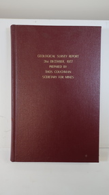
Book - Geographical Survey, Geographical Survey Report 31st Dec. 1977 prepared by Thos. Couchman Secretary for Mines
... Mines published progressive reports on the Geological Survey of parts of Victoria. This book includes a chapter on 'Dargo and Bogong' Pages 96 - 117 and includes a fold out map of this area. These pages show heavy use. geological survey 1878 dargo bogong First chapter and some pages have pencil marks including page 97. Hard deep red cover with gold ...Office of Mines published progressive reports on the Geological Survey of parts of Victoria.This book includes a chapter on 'Dargo and Bogong' Pages 96 - 117 and includes a fold out map of this area. These pages show heavy use.Hard deep red cover with gold printed title located at the centre top. Bound with spine blank. 217 pages. Date 1878 First chapter and some pages have pencil marks including page 97.geological survey 1878, dargo, bogong -
 Kiewa Valley Historical Society
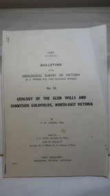
Document - Four Geological reports on the North-east Goldfields, Geological Survey of Victoria 1958 Bulletin
... Victoria included mines and tunnels. A resurvey of goldfields was necessary to re-assess economic possibilities using modern techniques and structural interpretation. It included an examination of a considerable surface area with maps and underground workings. Results were correlated and integrated and published by the Mines Department. The mines are in the Bogong Alpine Area. geology in the north-east gold ...Geological Surveys of N.E. Goldfields Victoria included mines and tunnels. A resurvey of goldfields was necessary to re-assess economic possibilities using modern techniques and structural interpretation. It included an examination of a considerable surface area with maps and underground workings. Results were correlated and integrated and published by the Mines Department.The mines are in the Bogong Alpine Area.Foolscap printed Victorian Bulletins. Each stapled in the top left corner and each with varying number of pages. Covering 1941-1958 a) Glen Wills and Sunnyside b) Sunnyside Tunnel c) Red Robin d) Maud and Yellow Girl Government Printer, Mines Department, Melbourne, Victoriageology in the north-east, gold fields, goldmines, glen wills -
Federation University Historical Collection
Document, Zelda Martin, Central Victorian Goldmining towns - Boom Towns or Ghost Towns?, c1996
... *Three articles published by Buninyong and District Historical Society Inc: (Magpie Exploration; Finding Gold In The Green Hills; Magpie Exploration; Burnt Bridge to Cargarie to Mt Mercer) *Copies of newspaper articles/items *Buninyong Street Directory Carisbrook: *In the Beginning There Was Carisbrook *The History of the Carisbrook Racecourse Carngham / Snake Valley: *Brief History *Directory Castlemaine: *Directory 1865-1866 - Alphabetical and Street *Poster - Castlemaine A Contemporary Guide "The Great Centre" 1866 - A Contemporary Guide to the Fascinating Past *Pamphlet - Castlemaine District Community Hospital *Map - Castlemaine, Maldon & Surrounding Districts *Map and Information - The Dry Diggings Track - a 55kl walk among historic goldfields relics ( Castlemaine Fryerstown Vaughan Mt Franklin Hepburn Daylesford) *Postcard - Former Court House *Directory 1867 - Alphabetical, Trade [.10] Resource No.3 Grey folder Titled Towns 3 Creswick to Maryborough Creswick: *Brief History *Booklet - "Creswick Cemetery Walk" *Booklet - The Buried Rivers of Gold Heritage Trail Creswick *Creswick Historical Museum Information Sheet *Chronological History of Creswick *Alphabetical Directory of the Borough of Creswick *Creswick's Creek Directory 1856 *Historic Creswick Walking Tour *A Brief Account of the Schools of Creswick - Past and Present *100 Years of Railway Travel in Creswick *The Berry Deep Leads *The Spence Home at Jackass Gully in the Creswick State Forest ( William Guthrie Spence - Pioneer) *The New Australian Mine and the 1882 Disaster *Creswick District News, Issue 7, July August 1999 *The Creswick Miners Walk - Information and Map *Maps Chewton: *Brief History *Directory Clunes: *Brief History *Clunes Street Directory Daylesford: *Brief History *Notable Bushfires in Daylesford District Over More Than a Century - "Black Thursday" 1851; 1862; 1899; the Disastrous Hepburn Fire of 1906; 1939; 1944; 1969. *Post Office Directory -Daylesford and Hepburn Dunolly / Inkerman: *Brief History *Directory *Pamphlet - Goldfields Historical Museum *Pamphlet - Historic Dunolly - Victoria's Best Kept Secret *Map of Gold...*Three articles published by Buninyong and District Historical Society Inc: (Magpie Exploration; Finding Gold In The Green Hills; Magpie Exploration; Burnt Bridge to Cargarie to Mt Mercer) *Copies of newspaper articles/items *Buninyong Street Directory Carisbrook: *In the Beginning There Was Carisbrook *The History of the Carisbrook Racecourse Carngham / Snake Valley: *Brief History *Directory Castlemaine: *Directory 1865-1866 - Alphabetical and Street *Poster - Castlemaine A Contemporary Guide "The Great Centre" 1866 - A Contemporary Guide to the Fascinating Past *Pamphlet - Castlemaine District Community Hospital *Map - Castlemaine, Maldon & Surrounding Districts *Map and Information - The Dry Diggings Track - a 55kl walk among historic goldfields relics ( Castlemaine Fryerstown Vaughan Mt Franklin Hepburn Daylesford) *Postcard - Former Court House *Directory 1867 - Alphabetical, Trade [.10] Resource No.3 Grey folder Titled Towns 3 Creswick to Maryborough Creswick: *Brief History *Booklet - "Creswick Cemetery Walk" *Booklet - The Buried Rivers of Gold Heritage Trail Creswick *Creswick Historical Museum Information Sheet *Chronological History of Creswick *Alphabetical Directory of the Borough of Creswick *Creswick's Creek Directory 1856 *Historic Creswick Walking Tour *A Brief Account of the Schools of Creswick - Past and Present *100 Years of Railway Travel in Creswick *The Berry Deep Leads *The Spence Home at Jackass Gully in the Creswick State Forest ( William Guthrie Spence - Pioneer) *The New Australian Mine and the 1882 Disaster *Creswick District News, Issue 7, July August 1999 *The Creswick Miners Walk - Information and Map *Maps Chewton: *Brief History *Directory Clunes: *Brief History *Clunes Street Directory Daylesford: *Brief History *Notable Bushfires in Daylesford District Over More Than a Century - "Black Thursday" 1851; 1862; 1899; the Disastrous Hepburn Fire of 1906; 1939; 1944; 1969. *Post Office Directory -Daylesford and Hepburn Dunolly / Inkerman: *Brief History *Directory *Pamphlet - Goldfields Historical Museum *Pamphlet - Historic Dunolly - Victoria's Best Kept Secret *Map of Gold ...Zelda Martin was a PhD candidate at the University of Melbourne.[.1] 4th item in light blue display book titled Research Approach/Overview of Chapters/Confirmation of Canditure/Chapters1,2,3&4 of proposed thesis. *Twenty-seven page article on Victorian goldfields towns titled: Central Victorian Goldmining Towns - Boom Towns or Ghost Towns. The article was written during the author's PhD study. It outlines the context methodology, and resources and the chapters of the proposed thesis: (1) Central Victorian Goldmining Towns - The Context (2) Contemporary Views of the Factors Necessary for Town Growth (3) Outward Manifestations of Town Growth (4) The Trappings of Government (5-9) The Main Towns and Their Hinterland. [.2] 5th item in Light Blue display book as above item. *Chapter 1 of proposed thesis titled 'Pick, Shovel and Tin Dish Mining.' Covers in Section A: Central Victoria - Pre 1851: Aborigines in Central Victoria, Squatters, and Government. Section B: The years 1851-1854: The Early Gold Rushes, Government Reaction, Township Surveys, Legislation, Town Development, Local Government and Early Settlement. [.3] 6th item in Light Blue display book as above item. *2A of proposed thesis titled 'Contemporary Views of the Factors Necessary for Town Growth'. Similar information to Chapter 1 plus extra re towns and maps. Sections: Introduction, Context of Place - Geographical Towns Listed, The Context of Time - Pre1851 Aborigines, Governance of Port Phillip, The Squatters, The Villages of Central Victorian Highlands, Conclusion, Condensed Version of Chapter2B. [.4] 7th item in Light Blue display book as above item. *Chapter2B of proposed thesis. Sections: Area of Research, Schools, Banks, Newspapers, Progress Association, Town Development - Sandhurst (Bendigo), Ballarat, Castlemaine,, Maryborough, Ararat and Stawell. [.5] 8th item in Light Blue display book as above item. *Chapter 3 of proposed thesis titled 'Outward Manifestations of Town Growth'. Sections: Introduction, Contemporary Writing, Educationalists, The Bankers, The Townsfolk, Current Theory, General Theories of Urban Development, and Conclusion. [.6] 9th item in Light Blue display book as above item. *Chapter 4 of proposed thesis titled 'Trappings of Government' Sections: Introduction, Early Government Attitudes to Mining and Town Development, Law and Order, Township Surveys, Legislation, Local Government, Transport and Communication, The People and Lobbyists. [.7] 10th item in Light Blue display book as above item. *'The Rise and Fall of Central Victorian Goldmining Towns'. Includes a map showing main Goldfields, a table showing towns and villages at two points in time - 1857 and 1871; a Bibliography of Primary and Secondary Sources. [.8] Resource No1. Black display book titled Local Towns 1 : Alma: *Brief history *Directory *Maps Amphitheatre / Mountain Hut: *Brief History Post Office Directory Ararat: *Brief History *Post Office Directory 1869 - Alphabetical Listing by Occupation *Ararat - Prominent Citizens of 1858 *Langi-Morgala Museum Avoca: *Brief History *Excerpts from 'Avoca The Early Years', Margery and Betty Beavis; pg1 - Beginnings; pg11 - The Midas Touch; pg25 - Local Gold Escorts; pg27 - A Town is Born; pg51- The Administration of Justice; pg53 - The Ways of the Law; pg61 - News of the Day; pg65 - A Time to Play; pg72 - Land Ownership *Post Office Directory (Bailliere's) 1869 *Tourism Map and Information of area *Historic Avoca - A 5.5km Tour *Avoca & the Pyrenees Region - information pamphlet Ballarat: *Early History of Ballarat - Ballarat Historical Society, Publication No.1: origin of the name; Ballaarat - the Beginning; Fabulous Yields from the Ballaarat Goldfield; *Streetscape Lydiard Street. *Hand drawn map showing Leigh River, Old Portland Bay Road, plaque on road to Colac; etc. *Newspaper article re 'The Theatre Royal' ( which stood in the vicinity of the current Owen Williams store) - 'The News'15/04/1998 *Article - 'Ballarat's Mechanics' Institute Lives On' Ballarat Courier, 14/09/1985 *Article - Standing the Test of Time' The News 17/11/1993 re The Mechanics Institute & picture of the Reading Room *'Ballarat a Study of a City, Phyllis Reichl, pub. Nelson, 1968; no.3 place, time and people field studies series *Investigator Vol.33 No.2, 1998 Geelong Historical Society. Article on pg75 describes Ballarat in 1861 *Folded poster - 'Ballarat 100' a history of telegraph communication, pub. Telecom. Beaufort (Fiery Creek): *Brief history *Post Office Directory [.9] Resource No.2 Black Folder Titled Towns cont.No2 Bendigo (Sandhurst): *'Family & Local History at the Bendigo Library - 1851-2001 150 years of gold'. *Bendigo Government Camp in 1853 illustration; key to sketch and names of Government officers stationed there *Excerpts from 'Bendigo and Vicinity' Adolph Haman *The Bendigo Goldfield Registry - pgs 1-7 Introduction *Excerpt: 'Breaking the Grip' *Excerpt: The Most Go-Ahead Place *Excerpts from 'History of Bendigo' - anti license agitation; laying out of town; proposed railway; gold calls and dividends; the Sandhurst Municipality; journalism *Bibliography Blackwood: *Excerpts from 'Aspects of Early Blackwood - The Goldfield, the Landmarks, the Pioneers' Alan J Buckingham and Margaret F Hitchcock, JG Publishing,1980 Buninyong: *A Brief History *Investigator Vol1 No.2 Feb 1966 Geelong Historical Society. Pg3 - Article re gold escort route - Mt Alexander to Adelaide - (see a simple monument on the Western Highway a few miles out of Horsham. Pg 15 - Ballarat Excursion - re the finding of gold. *Three articles published by Buninyong and District Historical Society Inc: (Magpie Exploration; Finding Gold In The Green Hills; Magpie Exploration; Burnt Bridge to Cargarie to Mt Mercer) *Copies of newspaper articles/items *Buninyong Street Directory Carisbrook: *In the Beginning There Was Carisbrook *The History of the Carisbrook Racecourse Carngham / Snake Valley: *Brief History *Directory Castlemaine: *Directory 1865-1866 - Alphabetical and Street *Poster - Castlemaine A Contemporary Guide "The Great Centre" 1866 - A Contemporary Guide to the Fascinating Past *Pamphlet - Castlemaine District Community Hospital *Map - Castlemaine, Maldon & Surrounding Districts *Map and Information - The Dry Diggings Track - a 55kl walk among historic goldfields relics ( Castlemaine Fryerstown Vaughan Mt Franklin Hepburn Daylesford) *Postcard - Former Court House *Directory 1867 - Alphabetical, Trade [.10] Resource No.3 Grey folder Titled Towns 3 Creswick to Maryborough Creswick: *Brief History *Booklet - "Creswick Cemetery Walk" *Booklet - The Buried Rivers of Gold Heritage Trail Creswick *Creswick Historical Museum Information Sheet *Chronological History of Creswick *Alphabetical Directory of the Borough of Creswick *Creswick's Creek Directory 1856 *Historic Creswick Walking Tour *A Brief Account of the Schools of Creswick - Past and Present *100 Years of Railway Travel in Creswick *The Berry Deep Leads *The Spence Home at Jackass Gully in the Creswick State Forest ( William Guthrie Spence - Pioneer) *The New Australian Mine and the 1882 Disaster *Creswick District News, Issue 7, July August 1999 *The Creswick Miners Walk - Information and Map *Maps Chewton: *Brief History *Directory Clunes: *Brief History *Clunes Street Directory Daylesford: *Brief History *Notable Bushfires in Daylesford District Over More Than a Century - "Black Thursday" 1851; 1862; 1899; the Disastrous Hepburn Fire of 1906; 1939; 1944; 1969. *Post Office Directory -Daylesford and Hepburn Dunolly / Inkerman: *Brief History *Directory *Pamphlet - Goldfields Historical Museum *Pamphlet - Historic Dunolly - Victoria's Best Kept Secret *Map of Gold Workings at Dunolly Area - showing where the main gold rushes occurred *Brief History - Inglewood *Directory - Inglewood - Name Occupation, Dwelling Kingower: *Brief History *Directory - Name / Ocupation / Dwelling Linton / Happy Valley / Piggoreet: *Brief History *Directory - Lintons McIvor: *"A History of the Shire and the Township of Heathcote" by J.O. Randell Majorca: *Brief History *Official Post Office Directory 1869 - Name / Occupation/ Address Maldon (Tarrangower): *Brief History Part 1 *Brief History Part 2 *Post Office Directory *List - Alphabetical Order by Names plus Business and Trade (Tarrangower Times Oct/1858) *List - Alphabetical Order by Trade plus Name and Business *Directory - Name / Occupation / Dwelling Maryborough: *Worsley Cottage - built by Arthur Worsley, a contractor in stonework in 1894 [.11] Resource No. 4 Blue Display Book titled Towns 4 Moliagul to Stawell Moliagul: *Brief History *Moligul Legislative Assembly (Voting?) List - Names and Occupations *Moliagul Victorian Post Office Directory 1868 - Name / Ocupation / Address / Comments *"The Welcome Stranger" gold nugget *The Sunday School *The Welcome Stranger Discovery Walk - information and map Moonambel (Mountain Creek) Redbank *Brief History *List of names extracted from advertisments of the Pioneer and Mountain Creek Advertiser 16/02/1861. *Bailliere's Directory 1869 - Alphabetical List of Name / Occupation / Place St Arnaud: *Brief History Sebastapol: *Brief History *Directory 1869 - Alphabetical by Name; plus occupation and address. Browns and Scarsdale: *Brief History *Browns Street Directory - Name and Occupation Smythesdale: *Brief Description *Smythesdale Street Directory -Name and Occupation Stawell (Pleasant Creek) *Brief History *Victorian Official Post Office Directory - Name /Occupation / Dwelling *Chronology - 1841-1920 *Production of gold statistics - 1879 - 1900 *Big Hill *Extracts from "The Golden Years of Stawell". Chapt 1 - Stawell's Coming Out. Capt. 2 - The Gold Rush. Caapt.3 - Cradle of Democracy. Chapt.4 - The Reefs Becomes Stawell. Chapt. 5 - Rushing In. Chapt.6 - The Pioneers. Chapt 7 - The Decade of Optimism. [.12] Resource No. 5: Blue Display Book titled 'Towns Steiglitz to the The Golden Triangle. Steiglitz: Brief History Victorian Post Office Directory 1869 *Map of Steiglitz *List of maps relevant to Steiglitz history *Information 6 tables of data from "Reports of Mining Surveyors Talbot (Back Creek) Brief History Taradale: Post office Directory 1869 - Name/Occupation/Street. Also list in alphabetical order by Occupation Taradale *Chronological Reference to Taradale Mines *Water - The Coliban System of Waterworks *Joseph Brady *The Syphon Tarnagulla (Sandy Creek) *Brief History *Tarnagulla Businessmen Cameos to give depth to advertisments in 'The Tarnagulla Courier' various issues 1864-1871 *Directory - Name/Occupation /Address *List - Name/Business/Trade Wedderburn (Koorong) *Brief History *List - Name/Occupation The Golden Triangle: *The Early Rushes - Wedderburn / Moliagul / Sandy Creek - Tarnagulla / Jones Creek - Waanyarra / Kingower / Dunolly - Goldsborough / Inglweood *Census of 1857 - Population / Occupations *1858-1871 - A Time of Consolidation- Wedderburn / Moliagul / Sandy Creek- Tarnagulla / Arnold *Census 1871 - Population *Information gleaned from the census data - Demographics / Population / Occupations / marital / Birthplace / Religion / Literacy/ Occupation and Housing Cameos *Graphs - Birthplace of settlers /Male-Female Ratio / Married males / Children under 15 as Percentage of Population / Religion *Census 1857 - Statistical data *Maps *Bibliography [.13] Resource No. 6 - Black Display Book Information and Research in Central Victoria including: *Banking - Research from ANZ Bank Archives *Institutions - also includes articles listed from the Ballarat Times Newspaper *Australian mining History Association - A.M.H.A. Bibliography *Australia's Mining History * Bibliography - Land Surveys Victoria - *1853 Administration (Statistics and Other) includes: schools / ministers of religion / police / military / local administration / licences for sale of spirits / distances between various Victorian gold fields. * Victoria Government Gazette (Copy) - N0. 116, 12/12/1854 includes: Gold Felds Commission of Enquiry & No. 85, 15/09/1854 - Addresses presented to the Lieutenant Governor (Sir Charles Hotham) during his tour through the Gold Fields of Victoria,1854. Addresses on behalf of : the people of Bendigo; Members of the Church of England, Bendigo; Members of the Wesleyan Church on the Bendigo Gold Fields; Bendigo Gold District General Hospital; the Bendigo Prospecting Association; Committee of the Bendigo Local Exhibition; Bendigo District Medical Association; Coloured Americans Resident at Bendigo; German Inhabitants of Bendigo; Landowners, Inhabitants, and Miners of Castlemaine; Inhabitants of Forest Creek; Inhabitants of Heathcote and Gold Miners of McIvor; Residents and landholders of the District of Bacchus Marsh; Inhabitants of Kilmore and Vicinity. *Gold Fields Correspondence 1853: letter from Lieutenant Colonel Valiant, (Officer commanding the Troops in Victoria) to the Lieutenant Governor re threatened disturbance at Sandhurst (Bendigo) regarding the Gold License Fee. * Extracts from a book "Victoria" re Gold Fields Commission of Enquiry involving mainly Ballarat and Castlemaine and a chapter titled 'A Tour to the Victorian Gold-Fields' *Lists of central Victorian newspapers - listed by date published 1851to 1874; by first date available to State Library. *A list of cities and towns showing County, population in 1861 &1871, and municipal status. [.14] Resource no.7. Black display book. *Reference: Papers presented to Parliament Victoria - 1859-1860 4 volumes - relevant sections copied. Contains information on Branches of Government. General / Finance / Gold / Gazette / Commission and Warrant / Statistic. *Gold Fields Act. In accordance with the Act the gold fields are divided into six districts - Ballaarat, Castlemaine , Sandhurst, Avoca, Ararat, and Beechworth.. Official staff in each gold district consists of a Resident Warden, Wardens, Wardens' Clerks, Bailiffs, Chinese Protectors, Chinese Interpreters, and Mining Surveyors. *Gold Receiver *Gaols *Police magistrates and Clerks of Petty Sessions, etc. *Field Branch *Immigration and Emigration Overland - Chinese - 1859 *Population on the Goldfields *The Geological Survey - The Government Geologist is assisited by staff from four branches - the office Branch; the Publishing Branch; the Field Branch and the Museum Branch. *Commission to Enquire Into Sludge dated 10/02/1859 (Some sections copied) - Report to the Honorable Chief Commissioner of Public Works, Melbourne re the mode of carrying the sludge from the puddling mills in Sandhurst without interfering with the drainage of the town and the roads in the neighbourhood. [.15] Resource No.8: Camel display book titled Resource No. 8. Aborigines *Lists of book titles - +"Readings in Victorian prehistory" +"The Aborigines of Port Phillip" +Aboriginal languages and clans" +"A History of the Port Phillip District" +"Langi Ghiran 1: Aboriginal Rock...." +"Koorie History: sources for aboriginal studies in the State Library of Victoria", ed. Tom Griffiths, Melb. Friends of the State Library, 1989 +"The Public Lands of Australia Felix"; settlement and land appraisal in Victoria1834-91 with special reference to the Western Plains", J.M.Powell, Melb. Oxford University Press 1970 +*Bibliography of the Victorian Aborigines' from the earliest manuscripts to 31st December 1970, Massoa, Aldo, Melb. Hawthorn Press, 1971 +"Aborigines in Colonial Victoria, 1836-1886", M.F. Christie, Sydney University Press, 1979 +"Urban and Industrial Australia: readings in Human Geography" ed J.M. Powell, Melb. Sorrett Pub. 1974 *Extracts: -Processes of Pioneer Settlement - The Squatting Occupation of Victoria, 1834-60. J.M. Powell -Areal Variations in the Class Structure of the Central-Place Hierarchy. P. Scott - Volume1 and Volume 2: Notes Relating to the Habits of the Natives of Other Parts of Australia and Tasmania. Compiled from various sources for the Government of Victoria by R Brough Smyth. John Curry, O'Neil, Melb. 1st pub. Melb. 1876. p31-45 - Numbers and Distribution of the Aborigines in Victoria -Victorian Aborigines 1835-1901 - A Resource Guide to the Holdings of the Public Record Office, Victoria; published by the Government Information Centre 1984. *History of the Aboriginal Artefacts Displayed in the Daylesford Museum. F. G. Powell (4 page pamphlet) *Letter to Zelda Martin from Peter Lovett, Cultural Officer, Ballarat & District Aboriginal Co- Operative, 05/02/1997 *Map: Ian Clarke Victorian Tribunal Boundary Map - Clans of Central Victoria. *Victorian Rock Art and Mythology - Article about Mount Langhi Ghiran and myths of the Tjapwarong people. *Two Aboriginal myths relating to the Grampians - 'The Monster Emu' / 'The Aquisition of Fire', by the Aborigines in the Grampians Areas *Article titled (chapter 8) Ballarat - information re camping sites in the region. Lake Wendouree / Lake Burrumbeet (includes a myth) / Mt Bunninyong / Lal Lal / Pitfield / Mount Elephant / Mount Egerton / Meredith / Lake Goldsmith / Lake Learmonth / Ercildoune *Notes on the Aborigines of the Wider Ballarat Region plus European names=Aboriginal names. John Morris 26/07/1995 *Role of Aborigines in Town Development in Central Victoria. Mentions Native Police Force est. in Port Phillip 1842 and Central Board for Aborigines est. 1860 *The Grave of King Billy. (Frank Wilson) Pamphlet. *Camping Places in Central and Northern Victoria. Article re Lake Burrumbeet site. *Programme for the Unveiling of Memorial Cairn for Edward Stone Parker 1802-1865. Note portrait not accurate. Accurate portrait is available in the book "A Successful Failure A Trilogy The Aborigines and Early Settlers", Edgar Morrison, Graffiti Publications, 2002. * Large envelope addressed to Mr G Netherway containing newspaper cuttings regarding the life of Edward Stone Parker, the unveiling of the Memorial Cairn as mentioned above, articles titled 'Episodes from Our Early Days' (Edgar Morrison, Yandoit)- The Black's School, A School At Last and The Final years. Also a typed page titled 'Historical Background to E.S.Parker's Career. Includes an interesting tale titled 'When the cat lay doggo' re laying power leads for the unveiling ceremony at the memorial site. [.16] green display folder titled 'Research Aids' *List of references to Commissioners' & W'ardens' Reports (formerly held at La Trobe Library Archives, now at Public Records Office [PRO]). Indicates town referred to / date of report / name of camp if different to town. * Archive information re Anglican Records *Movement around the Goldfields - Miners and Storekeepers - usefulness of newspapers in providing information - areas covered - Castlemaine, Maldon, Ararat, Stawell, Tarnagulla, Dunolly. *Port Phillip /Victoria Directories 1839/1867 - Chronological list of Directories included in this series. *"Notes on the History of Local Government in Victoria" A.W. Greig Melb. University Press 1925 - Photo-copied extract p5-p40. (Source - Deakin University Library) - Introduction by W.Harrison Moore. Section 1 - Development in New South Wales Before Separation. Section 2 - Development in Victoria After Its Separation from New South Wales. Hand written notations: 'roads, markets, and local government 1855 on' ;'opportunity of squatters in parliament' and 'opportunities of matters in parliament p33' * Notes on the Establishment of Surveyor General's Department 1851and Commissioner of Crown Lands and Survey. * Newspaper articles from The Argus, 1849, re the discovery of gold in the Pyrenees region. * Excerpt - a report on schools - A.B.Orlebar, Inspector; re the need for permanent school buildings rather than tents. *Excerpt from - 'Approaches to Urban History', Sean Glynn: The Case for Caution * Except from - 'The Urban Sprinkle', Weston Bate: Country Towns and Australian Regional History *Reference- 'The History of Land Tenure in the Colony of Victoria', John Quick. References the Haines Land Bill, land tenure and Land Leagues. [.17] Light blue envelope folder titled 'Birtchnell's Ballarat, etc. Directory 1862 *Contains various directories for Smythesdale, Buninyong, Clunes, Brown's and Creswick. [.18] Red envelope folder no.2 titled Victorian Gazetteer *Selected pages from 1869 Victorian Gazetteer on A4 paper (with a handwritten note questioning if some pages are from 1868 Victorian Gazetteer as appears to be different sizes - A3 pages.) Information includes locations and descriptions of towns, hotels, banks, communications and populations. (Does not include names, residences and occupations) [.19] Red Envelope folder titled Bailliere's Official Post Office Directory 1868 (or1869 or a mixture of both?) *Preface *Contains a selection of pages of towns highlighted in yellow in the the index *Work on this directory was commenced in 1867. *Information includes: Municipalities - mayors and councilors; lists of towns naming male inhabitants and their occupations. [.20]Yellow manila folder titled Post Grad Seminar Presentation 1996 *Gives some background to Zelda Martin's proposed thesis and why she chose the topic Gold Mining Towns Boom or Bust [.21] A3 display book - No. 1A * A list of 'Relevant Newspapers collected: The Tarrangower Times and Maldon Advertiser (first published 1858) Includes dates 1858-1867. The Mount Alexander Mail. Includes dates 1854-1866 The Tarnagulla Courier. Includes dates from1864-1871 Dunolly and Burnt Creek Express. Includes dates from 1862-1871 * Selection of newspaper pages from The Mount Alexander Mail 1854 to 1856, mostly showing advertisements for businesses and services provided to that community. [.22] A3 display book - No. 1B * Selection of newspaper pages from The Mount Alexander Mail 1857 to 1866, mostly showing advertisements for businesses and services provided to that community. [.23] A3 display book -No. 2 * Selection of newspaper pages from The Tarnagulla Courier 1864 to 1871, mostly showing advertisements for businesses and services provided to that community. [.24] A3 display book - No. 3 *Selection of newspaper pages from The Tarrangower Times (and Maldon and Newstead) Advertiser 1858 to1867, mostly showing advertisements for businesses and services provided to that community. [.25] A3 display book - No.4 * Selection of newspaper pages from The Dunolly and Burnt Creek Express; and The Dunolly and Betbetshire Express 1862 to 1871, mostly showing advertisements for businesses and services provided for that community. [.26] A3 display book - No.5 Includes: * Bryce Ross's Diggings Directory. Includes instructions for using this directory. This directory was used by "all persons having connexion or desiring to communicate with 'working parties, private friends, or Stores at the Diggings." As a directory for each area wwas completed it was published in each month's issue of Bonwick's "Digger's Magazine." Years c1852/1853. This Directory commences first at the head of Forest Creek. Includes a directory for Bendigo and Ballarat. Of interest at the end of the Bendigo and Ballarat directory is a list of the number of storekeepers, butchers, doctors, smiths, eating houses, lemonade sellers and chapels. * The Castlemaine Directory and Book of General Information Comprehending Glass's Model Calendar for the Two Years 1862 and1863. "zelda martin, victorian goldfield towns, bendigo, castlemaine, ballarat, maldon, stawell, ararat, maryborough, creswick, avoca, heathcote, banks, bank of australasia, union bank of australia, government camp, sandhurst, water supply, tarnagulla, talbot, back creek, mountain creek, police court, carisbrook, dunolly, thompson's foundry, charles clacy, anthony trollope, robert cecil, mount alexander, urbanisation, national schools, education, govenrment, industry, railway, transport, settlement, land settlement in central victoria, steiglitz, joseph brady, the new australian mine, berry deep leads, william guthrie spence, creswick state forest, arthur worsley, worsley cottage, the welcome stranger, moliagul, moonambel, redbank, st arnaud, sebastapol, brown's, scarsdale, clunes, chewton, daylesford, bushfires, inkerman, inglewood, kingower, lintons, happy valley, piggoreet, mcivor, majorca, tarrangower, taradale, the coliban system, the syphon, sandy creek, wedderburn, koorong, arnold, jones creek, waanyarra, the golden triangle, census 1857, blackwood, buninyong, durham lead, magpie, carngham, snake valley, alma, amherst, daisy hill, amphitheatre, mountain hut, beaufort, fiery creek, counties, population, gold fields commission of enquiry1854, william westgarth, gold license fee, lieutenant colonel valiant, administration of the victorian gold fields, commission to enquire into sludge 1859, e.s. parker, edward stone parker, edgar morrison, mount franklin protectorate, dja dja wurrung, memorial cairn, franklinford, mt franklin memorial cairn, jajowurrong, dja dja wurung, tjaowarong, wothowurong, assistant protectors, daylesford museum, buluk, rock art - grampians, aboriginal mythology - grampians, aborigines, first nations people, mount franklin, aboriginal artifacts, lake burrumbeet, native police force, central board of aborigines, yandoit, commissioners' reports, wardens' reports, port phillip/victoria directories 1839-1867, local government - victoria 1853/1854, surveyor general's department - 1850's, victorian schools 1850's, a.b.orlebar, haines land bill, william charles haines, wilson gray, land tenure, land leagues, victorian gazetteer, the tarrangower times and maldon advertiser - 1858-1867, the mount alexander mail 1854-1866, the tarnagulla courier 1864, dunolly and burnt creek express 1862-1871, bryce rose's diggings directory, the castlemaine directory 1862-1863 -
 Federation University Historical Collection
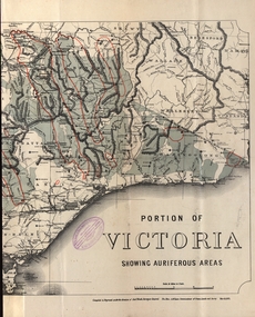
Map - Map and Information, Department of Mines: Map and Suggestions to Prospectors, 1891
... The map outlines the auriferous (gold bearing) areas in Victoria. The information for prospectors was prepared by the Department of Mines in 1894...Barker Library (top floor) Mount Helen goldfields The map outlines the auriferous (gold bearing) areas in Victoria. The information for prospectors was prepared by the Department of Mines in 1894 gold auriferous areas department of mines victoria map of victoria prospectors commissioner of crown lands hon a mclean alexander black surveyor general a mclean Reference section on map Document: 4 page type written Map: Portion of Victoria divided into Counties of 1891. ...The map outlines the auriferous (gold bearing) areas in Victoria. The information for prospectors was prepared by the Department of Mines in 1894Document: 4 page type written Map: Portion of Victoria divided into Counties of 1891. Auriferous areas with red.Reference section on mapgold, auriferous areas, department of mines, victoria, map of victoria, prospectors, commissioner of crown lands, hon a mclean, alexander black, surveyor general, a mclean -
Federation University Historical Collection
Booklet - Walking Guide, Ballarat Heritage Walking Guide, c2015
... Barker Library (top floor) Mount Helen goldfields Ballarat Walking trail Statues Gold Monument Sturt Street unicorn hotel Ballarat Town hall Sugg light Ballarat Post Office Camp Street Summerscales Building State Offices Police court Huyghue House Pratt's Building YMCA Ballarat Trades Hall ANA Hall maps Lydiard Street Ballarat Gaol Ballarat School of Mines Wesleyan Church Ansonia Lynn's Chambers Craig's Royal Hotel her Majesty's Theatre Union Bank Building Bank of Australasia National Bank Colonial Bank of Australasia Bank of New South Wales George Hotel Old Colonists' hall Art Gallery of Ballarat Union Fidelity Hall Goller's Warehouse Dunn's Warehouse Ludbrook House Reid's Coffe Police Ballarat Railway Station Cenotaph Queen Victoria Fountain Boer War Memorial Burke and Wills Founitain Titanic Memorial Bandstand 35 page booklet with a detail from the Mining Exchange on the front. ...35 page booklet with a detail from the Mining Exchange on the front. ballarat, walking trail, statues, gold monument, sturt street, unicorn hotel, ballarat town hall, sugg light, ballarat post office, camp street, summerscales building, state offices, police court, huyghue house, pratt's building, ymca, ballarat trades hall, ana hall, maps, lydiard street, ballarat gaol, ballarat school of mines, wesleyan church, ansonia, lynn's chambers, craig's royal hotel, her majesty's theatre, union bank building, bank of australasia, national bank, colonial bank of australasia, bank of new south wales, george hotel, old colonists' hall, art gallery of ballarat, union fidelity hall, goller's warehouse, dunn's warehouse, ludbrook house, reid's coffe police, ballarat railway station, cenotaph, queen victoria fountain, boer war memorial, burke and wills founitain, titanic memorial bandstand -
 Bendigo Historical Society Inc.
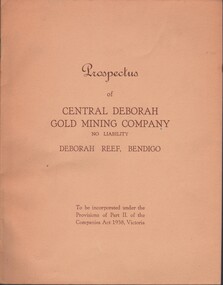
Document - MCCOLL, RANKIN AND STANISTREET COLLECTION: CENTRAL DEBORAH GOLD MINE NL: PROSPECTUS, 1939
... Gold Mine NL - 4 copies of prospectus. Buff covered booklet. Written on front ' Prospectus of Central Deborah Gold Mining Company No Liability Deborah Reef, Bendigo. To be incorporated under the Provisions of Part II of the companies Act 1938. Victoria.' Details capital, proposed directors and manager. Contains map...gold mine McColl Rankin & Stanistreet Collection: Central Deborah Gold Mine NL. Gold mining Document: McColl, Rankin & Stanistreet Collection: Central Deborah Gold Mine NL - 4 copies of prospectus. Buff covered booklet. Written on front ' Prospectus of Central Deborah Gold Mining Company No Liability Deborah Reef, Bendigo. To be incorporated under the Provisions of Part II of the companies Act 1938. Victoria.' Details capital, proposed directors and manager. Contains map ...Document: McColl, Rankin & Stanistreet Collection: Central Deborah Gold Mine NL - 4 copies of prospectus. Buff covered booklet. Written on front ' Prospectus of Central Deborah Gold Mining Company No Liability Deborah Reef, Bendigo. To be incorporated under the Provisions of Part II of the companies Act 1938. Victoria.' Details capital, proposed directors and manager. Contains map of Central and North Deborah mines and Monument Hill.organization, business, central deborah gold mine, mccoll, rankin & stanistreet collection: central deborah gold mine nl. gold mining -
 Bendigo Historical Society Inc.
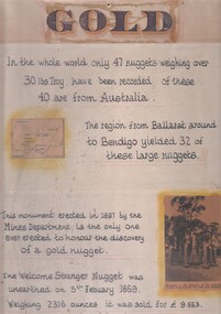
Document - 'GOLD' POSTER WITH DESCRIPTION OF NUGGETS
... Gold' - 'In the whole world, only 47 nuggets weighing over 30lbs Troy have been recorded. Of these 40 are from Australia. The region from Ballarat around to Bendigo yielded 32 of these large nuggets. This monument erected in 1897 by the Mines Department, is the only one ever erected to honour the discovery of a gold nugget. The 'Welcome Stranger' nugget was unearthed on 5th February, 1869, weighing 2316 ounces and it was sold for 9.553 pounds'. Poster includes a map of Victoria...Gold' - 'In the whole world, only 47 nuggets weighing over 30lbs Troy have been recorded. Of these 40 are from Australia. The region from Ballarat around to Bendigo yielded 32 of these large nuggets. This monument erected in 1897 by the Mines Department, is the only one ever erected to honour the discovery of a gold nugget. The 'Welcome Stranger' nugget was unearthed on 5th February, 1869, weighing 2316 ounces and it was sold for 9.553 pounds'. Poster includes a map of Victoria ...Poster heading - 'Gold' - 'In the whole world, only 47 nuggets weighing over 30lbs Troy have been recorded. Of these 40 are from Australia. The region from Ballarat around to Bendigo yielded 32 of these large nuggets. This monument erected in 1897 by the Mines Department, is the only one ever erected to honour the discovery of a gold nugget. The 'Welcome Stranger' nugget was unearthed on 5th February, 1869, weighing 2316 ounces and it was sold for 9.553 pounds'. Poster includes a map of Victoria depicting the main gold mining areas, also mention of gypsum, and tin in northern Victoria. A photo of the monument to the discovery of the 'Welcome Stranger' nugget found 1 1/4 miles from Moliagul in the bottom corner.document, gold -
 Bendigo Historical Society Inc.
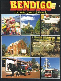
Book - BENDIGO, THE GOLDEN HEART OF VICTORIA
... gold mine talking tram. Rosalie Trower, Annette Boyle Bendigo The Golden Heart Of Victoria 22 pages with colour photos and maps. ...Bendigo The Golden Heart Of Victoria 22 pages with colour photos and maps.Rosalie Trower, Annette Boylebendigo, tourism, bendigo, sacred heart cathedral, sandhurst town, central deborah gold mine, talking tram. -
 Bendigo Historical Society Inc.
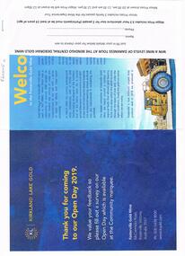
Document - FOSTERVILLE GOLD MINE COLLECTION: OPEN DAY 2019
... Open Day activities include: bus tours, technical services display, geology, exploration, processing, community and environment display, minerals council of Australia, Swick drilling, Central Deborah Gold Mine, Face painting, Goldfields Re-vegetation, Delecca's hire equipment, MacMahon underground mining services, Sandvik, and ISH24 safety specialists. Map of 'Fosterville Gold Mine Site Map' with activities highlighted. Fosterville is Victoria's...Gold Mine Two page document for Kirkland Lake Gold Open day 2019. Open Day activities include: bus tours, technical services display, geology, exploration, processing, community and environment display, minerals council of Australia, Swick drilling, Central Deborah Gold Mine, Face painting, Goldfields Re-vegetation, Delecca's hire equipment, MacMahon underground mining services, Sandvik, and ISH24 safety specialists. Map of 'Fosterville Gold Mine Site Map' with activities highlighted. Fosterville is Victoria's ...Two page document for Kirkland Lake Gold Open day 2019. Open Day activities include: bus tours, technical services display, geology, exploration, processing, community and environment display, minerals council of Australia, Swick drilling, Central Deborah Gold Mine, Face painting, Goldfields Re-vegetation, Delecca's hire equipment, MacMahon underground mining services, Sandvik, and ISH24 safety specialists. Map of 'Fosterville Gold Mine Site Map' with activities highlighted. Fosterville is Victoria's larges gold producer and in 2918 a records 356,230 ounces at an average grade of 24.9 g per tonne. The mine has over 600 full time employees in 2019. Entry for '9 levels of darkness' tour at Central Deborah Mine attached.bendigo, mining, fosterville gold mine -
 Bendigo Historical Society Inc.
Book - MINING & GEOLOGICAL JOURNAL. VOL,4. NO,4, 1951
... Published by Department of Mines Victoria with 65 pages of articles on gold, coal & oil mining, Illustrations, maps, photographs including photographs of Bendigo mines. ...Mines. Dept of Mines Victoria Mining and Geological Journal, Volume 4, No.4. September 1951. Published by Department of Mines Victoria with 65 pages of articles on gold, coal & oil mining, Illustrations, maps, photographs including photographs of Bendigo mines. ...Mining and Geological Journal, Volume 4, No.4. September 1951. Published by Department of Mines Victoria with 65 pages of articles on gold, coal & oil mining, Illustrations, maps, photographs including photographs of Bendigo mines. Name noted on front A.E.Richardson 29 Harrison St Bendigo.Dept of Mines Victoriamagazine, organization, mining, mining - mines - mining equipment, bendigo mines. -
 Bendigo Historical Society Inc.
Book - MINING & GEOLOGICAL JOURNAL. VOL,4. NO.3, 1951
... GOLD MINES mining Mining - Mines - Mining Equipment Central Deborah Mine. Dept of Mines Victoria. Mining and Geological Journal, Vol.4, No.3. March 1951. Published by Department of Mines Victoria with articles on Mines & mining including Bendigo mines with Photographs, Illustrations, Maps & Advertisements. ...Mining and Geological Journal, Vol.4, No.3. March 1951. Published by Department of Mines Victoria with articles on Mines & mining including Bendigo mines with Photographs, Illustrations, Maps & Advertisements. Name on front A.Richardson 29 Harrison St Bendigo.Dept of Mines Victoria.gold mines, mining, mining - mines - mining equipment, central deborah mine. -
 Bendigo Historical Society Inc.
Book - MINING & GEOLOGICAL JOURNAL. VOL.S,NO.6, 1942
... GOLD MINES mining Mining - Mines - Mining Equipment. Bendigo mines. Dept of Mines Victoria Mining & Geological Journal, Vol.2, No.6. March 1942. Published by Department of Mines Victoria, with articles on mines and mining including Bendigo mines, Photographs, Illustrations, Maps & Advertisements. ...Mining & Geological Journal, Vol.2, No.6. March 1942. Published by Department of Mines Victoria, with articles on mines and mining including Bendigo mines, Photographs, Illustrations, Maps & Advertisements. Name on cover A Richardson 29 Harrison St Bendigo.Dept of Mines Victoriagold mines, mining, mining - mines - mining equipment. bendigo mines. -
 Bendigo Historical Society Inc.
Book - MINING & GEOLOGICAL JOURNAL VOL.2, NO2, 1940
... GOLD MINES mining Mining - Mines - Mining Equipment Axedale - Fletchers mine. Dept of Mines Victoria Mining & Geological Journal, January 1940, Vol.2, No.2. Published by Department of Mines Victoria, 136 pages of Mine Reports, articles on mines, photographs, illustrations, maps & advertisements. ...Mining & Geological Journal, January 1940, Vol.2, No.2. Published by Department of Mines Victoria, 136 pages of Mine Reports, articles on mines, photographs, illustrations, maps & advertisements. Name on cover A.Richardson 29 Harrison St Bendigo.Dept of Mines Victoriagold mines, mining, mining - mines - mining equipment, axedale - fletchers mine. -
 Bendigo Historical Society Inc.
Document - MCCOLL, RANKIN AND STANISTREET COLLECTION: NAPOLEON REEF GOLD MINING CO. N.L, 22 August 1950
... History House 11 Mackenzie Street Bendigo goldfields ORGANIZATION Business industrial - mining McColl Rankin & Stanistreet mining gold mining Napoleon Reef Document: 5 Page legal document with map of lease area, Lease No. 11273 Bendigo, Vol.331, Fol. 36453, 15 year lease from 12 December 1949, in vicinity of Inglis, Harvey & Curnow Streets, Signed by Dallas Brooks, Gov of Victoria & J.J. Stanistreet, Mine ...Document: 5 Page legal document with map of lease area, Lease No. 11273 Bendigo, Vol.331, Fol. 36453, 15 year lease from 12 December 1949, in vicinity of Inglis, Harvey & Curnow Streets, Signed by Dallas Brooks, Gov of Victoria & J.J. Stanistreet, Mine Manager.organization, business, industrial - mining, mccoll rankin & stanistreet, mining, gold mining, napoleon reef -
 Bendigo Historical Society Inc.
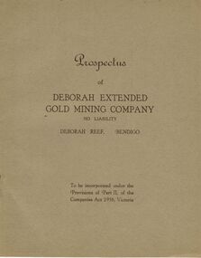
Document - MCCOLL, RANKIN AND STANISTREET COLLECTION: DEBORAH EXTENDED GOLD MINING COMPANY NL, 1940
... Gold Mining Company No Liability, Deborah Reef, Bendigo. To be incorporated under the Provisions of Part II, of the Companies Act 1938, Victoria. Application form and map of mines...History House 11 Mackenzie Street Bendigo goldfields ORGANIZATION Mining deborah extended gold mining cpy nl McColl Rankin & Stanistreet Deborah Extended Gold Mining Company NL Prospectus profit and loss account for 31 August 1945 map of mine form application McColl Rankin & Stanistreet, 12 Copies of Prospectus of Deborah Extended Gold Mining Company No Liability, Deborah Reef, Bendigo. To be incorporated under the Provisions of Part II, of the Companies Act 1938, Victoria ...McColl Rankin & Stanistreet, 12 Copies of Prospectus of Deborah Extended Gold Mining Company No Liability, Deborah Reef, Bendigo. To be incorporated under the Provisions of Part II, of the Companies Act 1938, Victoria. Application form and map of mines included in book form, dated 1940. Profit and Loss Account for Term ended 31st August, 1945 also included on separate sheet (has been folded in half across). Auditors: Wm. R. McKie & W. J. Sparkman.organization, mining, deborah extended gold mining cpy nl, mccoll rankin & stanistreet, deborah extended gold mining company nl, prospectus, profit and loss account for 31 august 1945, map of mine, form application -
 Bendigo Historical Society Inc.
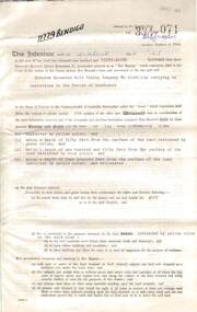
Document - MCCOLL, RANKIN AND STANISTREET COLLECTION: DEBORAH EXTENDED GOLD MINING COMPANY N/L GOLD MINING LEASE, 18 April 1957
... History House 11 Mackenzie Street Bendigo goldfields ORGANIZATION Mining gold mining lease Deborah Extended Gold Mine Gold Mining Lease Document Deborah Extended Gold Mining Company N/L document - gold mining lease document, Vol 334 071, dated 18 April 1957, 4 pages with map. Map adjoins Bendigo Cemetery. Lease between Deborah Extended Gold Mining Company N/L and the State of Victoria ...Document Deborah Extended Gold Mining Company N/L document - gold mining lease document, Vol 334 071, dated 18 April 1957, 4 pages with map. Map adjoins Bendigo Cemetery. Lease between Deborah Extended Gold Mining Company N/L and the State of Victoria. No. 11339, Vol 334 Fol 071.organization, mining, gold mining lease, deborah extended gold mine, gold mining lease -
 Bendigo Historical Society Inc.
Document - MCCOLL, RANKIN AND STANISTREET COLLECTION: GOLD MINING LEASE RONALD ALEXANDER RANKIN, 1941
... Document: McColl, Rankin and Stanistreet: lease document between Ronald Alexander Rankin of Bendigo and the State of Victoria. 3 pages with map - lease adjoins Bellevue Road. Lease transferred to Deborah Gold Mines NL in 1945....History House 11 Mackenzie Street Bendigo goldfields ORGANIZATION Mining gold mining lease McColl Rankin and Stanistreet: Ronald Alexander Rankin lease document gold mining Document: McColl, Rankin and Stanistreet: lease document between Ronald Alexander Rankin of Bendigo and the State of Victoria. 3 pages with map - lease adjoins Bellevue Road. Lease transferred to Deborah Gold Mines ...Document: McColl, Rankin and Stanistreet: lease document between Ronald Alexander Rankin of Bendigo and the State of Victoria. 3 pages with map - lease adjoins Bellevue Road. Lease transferred to Deborah Gold Mines NL in 1945.organization, mining, gold mining lease, mccoll, rankin and stanistreet:, ronald alexander rankin, lease document, gold mining -
 Bendigo Historical Society Inc.
Map - MINING PLAN ,VICTORIA HILL AREA, No date visible
... History House 11 Mackenzie Street Bendigo goldfields MAP Bendigo mining plan Mining Gold Mines Victoria Hill Lines of Reef Map: Large scale plan of an area of the Goldfield, Northward from Barnard Street, covering the Victoria Hill area. ...Map: Large scale plan of an area of the Goldfield, Northward from Barnard Street, covering the Victoria Hill area. Black printing on polycarbonate film. Transparent.map, bendigo, mining plan, mining, gold mines, victoria hill, lines of reef -
Bendigo Historical Society Inc.
Map - BIG 180 SHAFT POSITION, No date visible
... History House 11 Mackenzie Street Bendigo goldfields MAP Bendigo mining plan Mining Gold Mines. Victoria Hill Big 180 Map: Plan showing the location of various shafts in the Victoria Hill area, hand draughted in pencil. ...Map: Plan showing the location of various shafts in the Victoria Hill area, hand draughted in pencil. Scale 2 Chains to 1 inchmap, bendigo, mining plan, mining , gold mines. victoria hill, big 180 -
 Bendigo Historical Society Inc.
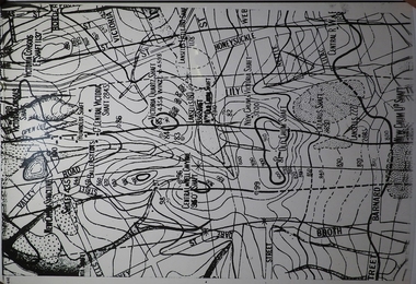
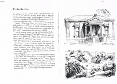
Document - LONG GULLY HISTORY GROUP COLLECTION: VICTORIA HILL
... History House 11 Mackenzie Street Bendigo goldfields BENDIGO History long gully history group The Long Gully History Group - Victoria Hill Gold Mines Hotel Christopher Ballerstedt Theodore Ballerstedt Ballerstedt's Open Cut Lansell's 180 Mine Little 180 Mine New Chum Syncline Battery Victoria Reef Quartz Mining Co Victoria Quartz New Chum Drainage Scheme A Roberts and Sons Tributors William Rae's Bon Accord Mine and Open Cut William Rae Adventure and Advance open Cuts Central Nell Gwynne Heinz Butcher Shop Three pages numbered 18/19, 20/21 and 22/23 titled Victoria Hill. First page has some information on Victoria Hill, a sketch of W Rae's Home and Rae's Open cut. The second page has a map ...Three pages numbered 18/19, 20/21 and 22/23 titled Victoria Hill. First page has some information on Victoria Hill, a sketch of W Rae's Home and Rae's Open cut. The second page has a map of the Victoria Hill Area showing streets and the New Chum Anticline, a sketch of Ballerstedt's Open Cut and a Key to Victoria Hill Area Map. The third page mentions the Victoria Quartz mine, Tributors and quartz roasting. It also has sketch of a 20 Head Crushing Battery, Victoria Hill.bendigo, history, long gully history group, the long gully history group - victoria hill, gold mines hotel, christopher ballerstedt, theodore ballerstedt, ballerstedt's open cut, lansell's 180 mine, little 180 mine, new chum syncline battery, victoria reef quartz mining co, victoria quartz, new chum drainage scheme, a roberts and sons, tributors, william rae's bon accord mine and open cut, william rae, adventure and advance open cuts, central nell gwynne, heinz butcher shop -
 The Beechworth Burke Museum
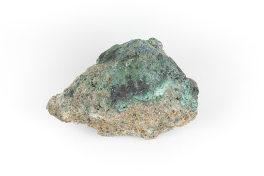
Geological specimen - Malachite, Unknown
... Victoria that begun in 1852 (in response to the Gold Rush) to study and map the geology of Victoria. Collecting geological specimens was an important part of mapping and understanding the scientific makeup of the earth. Many of these specimens were sent to research and collecting organisations across Australia, including the Burke Museum, to educate and encourage further study. burke museum beechworth indigo shire beechworth museum geological geological specimen mineralogy burra burra burra mine south australia malachite malachite specimen A solid hand-sized copper carbonate hydroxide mineral with shades of blue and light green throughout. ...Malachite is typically found as crystalline aggregates or crusts, often banded in appearance, like agates. It is also often found as botryoidal clusters of radiating crystals, and as mammillary aggregates as well. Single crystals and clusters of distinguishable crystals are uncommon, but when found they are typically acicular to prismatic. It is also frequently found as a pseudomorph after Azurite crystals, which are generally more tabular in shape. This particular specimen was recovered from the Burra Burra Copper Mine in Burra, South Australia. Otherwise known as the 'Monster Mine', the Burra Burra Copper Mine was first established in 1848 upon the discovery of copper deposits in 1845. Within a few short years, people from around the world migrated to Burra to lay their claim in the copper economy. By April 1848 the mine was employing over 567 people and supporting a population of 1,500 in the local township. Up until 1860, the mine was the largest metals mine in Australia, producing approximately 50,000 tonnes of copper between 1845 to its closure in 1877. The Burra Burra Mine was also famous for a number of other specimens, including; crystalline azurite, cuprite, and botryoidal and malachite. Malachite is considered a rare gemstone in that the original deposits for the stones have been depleted leaving behind very few sources. In addition, the use of Malachite as gemstones and sculptural materials remains just as popular today as they were throughout history. It is quite common to cut the stone into beads for jewellery. The fact that Malachite has such a rich colour and one that does not fade with time or when exposed to light makes it particularly rare. This specimen is part of a larger collection of geological and mineral specimens collected from around Australia (and some parts of the world) and donated to the Burke Museum between 1868-1880. A large percentage of these specimens were collected in Victoria as part of the Geological Survey of Victoria that begun in 1852 (in response to the Gold Rush) to study and map the geology of Victoria. Collecting geological specimens was an important part of mapping and understanding the scientific makeup of the earth. Many of these specimens were sent to research and collecting organisations across Australia, including the Burke Museum, to educate and encourage further study. A solid hand-sized copper carbonate hydroxide mineral with shades of blue and light green throughout. burke museum, beechworth, indigo shire, beechworth museum, geological, geological specimen, mineralogy, burra, burra burra mine, south australia, malachite, malachite specimen -
 The Beechworth Burke Museum
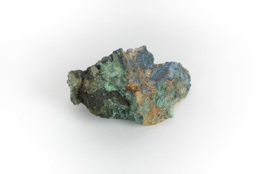
Geological specimen - Malachite, Unknown
... Victoria that begun in 1852 (in response to the Gold Rush) to study and map the geology of Victoria. Collecting geological specimens was an important part of mapping and understanding the scientific makeup of the earth. Many of these specimens were sent to research and collecting organisations across Australia, including the Burke Museum, to educate and encourage further study. geological geological specimen burke museum indigo shire malachite malachite specimen burra burra mine burra south australia australian mines mines monster mine A solid hand-sized copper carbonate hydroxide mineral with shades of yellow, blue, and light green throughout. ...Malachite is a green copper carbonate hydroxide mineral and was one of the first ores used to make copper metal. Malachite has been utilised as a gemstone and sculptural material in the past as its distinctive green color does not fade when exposed to light or after long periods of time. Malachite is formed at shallow depths in the ground, in the oxidizing zone above copper deposits. The material has also been used as a pigment for painting throughout history. This particular specimen was recovered from the Burra Burra Copper Mine in Burra, South Australia. Otherwise known as the 'Monster Mine', the Burra Burra Copper Mine was first established in 1848 upon the discovery of copper deposits in 1845. Within a few short years, people from around the world migrated to Burra to lay their claim in the copper economy. By April 1848 the mine was employing over 567 people and supporting a population of 1,500 in the local township. Up until 1860, the mine was the largest metals mine in Australia, producing approximately 50,000 tonnes of copper between 1845 to its closure in 1877. The Burra Burra Mine was also famous for a number of other specimens, including; crystalline azurite, cuprite, and botryoidal and malachite.Malachite is considered a rare gemstone in that the original deposits for the stones have been depleted leaving behind very few sources. In addition, the use of Malachite as gemstones and sculptural materials remains just as popular today as they were throughout history. It is quite common to cut the stone into beads for jewellery. The fact that Malachite has such a rich colour and one that does not fade with time or when exposed to light makes it particularly rare. This specimen is part of a larger collection of geological and mineral specimens collected from around Australia (and some parts of the world) and donated to the Burke Museum between 1868-1880. A large percentage of these specimens were collected in Victoria as part of the Geological Survey of Victoria that begun in 1852 (in response to the Gold Rush) to study and map the geology of Victoria. Collecting geological specimens was an important part of mapping and understanding the scientific makeup of the earth. Many of these specimens were sent to research and collecting organisations across Australia, including the Burke Museum, to educate and encourage further study. A solid hand-sized copper carbonate hydroxide mineral with shades of yellow, blue, and light green throughout.geological, geological specimen, burke museum, indigo shire, malachite, malachite specimen, burra burra mine, burra, south australia, australian mines, mines, monster mine -
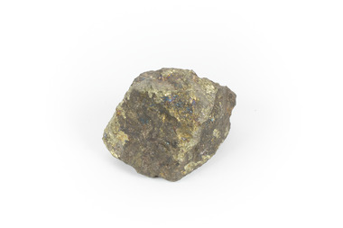
 The Beechworth Burke Museum
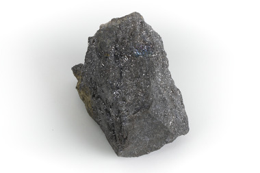
Geological specimen - Galena Chalcopyrite, Unknown
... mined in the country and after being made into lead, was used for a variety of things such as paint, batteries, ammunition, and plumbing materials before it was known to be harmful to humans. This specimen is part of a larger collection of geological and mineral specimens collected from around Australia (and some parts of the world) and donated to the Burke Museum between 1868-1880. A large percentage of these specimens were collected in Victoria as part of the Geological Survey of Victoria that begun in 1852 (in response to the Gold Rush) to study and map ...Galena Chalcopyrite is the earth's primary ore of lead and is mined from a large number of deposits in many countries. It is also an important source of silver. Galena Chalcopyrite is one of the most abundant and widely distributed sulfide minerals across the world. The mineral is found in igneous and metamorphic rocks in medium- to low-temperature hydrothermal veins. This specific specimen was recovered from the mines in Broken Hill, New South Wales. The mines in Broken Hill were first established after Charles Rasp discovered a large amount of silver-lead-zinc ore-body in the area in 1883. BHP (Broken Hill Proprietary) mining company was then established in 1885 and quickly became the lead in Australia's mining industry after they began excavating and exporting the country's largest amount of lead, silver, and zinc. This feat generated over $100 billion in wealth for the company.Galena Chalcopyrite is signifiant as it represents the catalyst for the rise of Australia's most influential mining companies - BHP. The mineral was one of the first to be mined in the country and after being made into lead, was used for a variety of things such as paint, batteries, ammunition, and plumbing materials before it was known to be harmful to humans. This specimen is part of a larger collection of geological and mineral specimens collected from around Australia (and some parts of the world) and donated to the Burke Museum between 1868-1880. A large percentage of these specimens were collected in Victoria as part of the Geological Survey of Victoria that begun in 1852 (in response to the Gold Rush) to study and map the geology of Victoria. Collecting geological specimens was an important part of mapping and understanding the scientific makeup of the earth. Many of these specimens were sent to research and collecting organisations across Australia, including the Burke Museum, to educate and encourage further study. A grey, solid hand-sized lead sulfide mineral with a silver metallic luster.burke museum, beechworth, geological, geological specimen, galena, galena chalcopyrite, chalcopyrite, broken hill, bhp, bhp mining, broken hill mine, mine, australia mine, lead, lead mine -
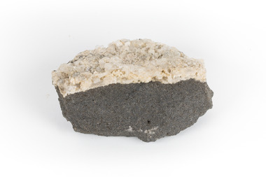 The Beechworth Burke Museum
Geological specimen - Hyalite in Basalt
... Victoria that begun in 1852 (in response to the Gold Rush) to study and map the geology of Victoria. Collecting geological specimens was an important part of mapping and understanding the scientific makeup of the earth. Many of these specimens were sent to research and collecting organisations across Australia, including the Burke Museum, to educate and encourage further study. Burke Museum Geological Specimen Department of Mines ...According to the 1912 Department of Mines Bulletin of the Geological Survey of Victoria, basalt covers a considerable portion of the Macedon area including Mount Macedon. Basalt is the most common form of rock underlying the earth's surface and is found in three kinds of rock forming environments: ocean divergent boundaries, oceanic hotspots, and mantle plumes and hotspots beneath continents.This specimen is part of a larger collection of geological and mineral specimens collected from around Australia (and some parts of the world) and donated to the Burke Museum between 1868-1880. A large percentage of these specimens were collected in Victoria as part of the Geological Survey of Victoria that begun in 1852 (in response to the Gold Rush) to study and map the geology of Victoria. Collecting geological specimens was an important part of mapping and understanding the scientific makeup of the earth. Many of these specimens were sent to research and collecting organisations across Australia, including the Burke Museum, to educate and encourage further study.A solid mass, geological specimen in shades of grey and white. Hyalite is a colourless variety of opal. It occurs as globular and botryoidal masses and irregular crusts in volcanic and pegmatite environments where the silica deposits from the gas phase. Basalt is dark in colour, fine-grained igneous rock composed of plagioclase and pyroxene minerals. It is commonly formed as an extrusive rock, such as lava flow. It is one of the most common forms of rock underlying the earth's surface.burke museum, geological specimen, department of mines, geological survey of victoria, basalt, mount macedon, beechworth -
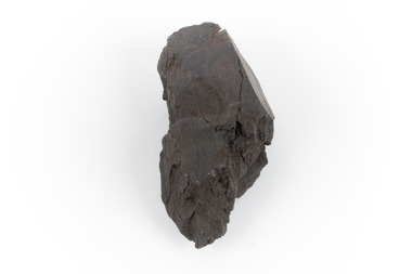 The Beechworth Burke Museum
Geological specimen - Brown coal
... Victoria that begun in 1852 (in response to the Gold Rush) to study and map the geology of Victoria. Collecting geological specimens was an important part of mapping and understanding the scientific makeup of the earth. Many of these specimens were sent to research and collecting organisations across Australia, including the Burke Museum, to educate and encourage further study. burke museum beechworth indigo shire beechworth museum geological geological specimen mineralogy brown coal brown coal specimen lignite lal lal lal lal coal mine lal lal iron mine ballarat blast furnace A hand-sized light-weight, soft and combustable sedimentary rock specimen, that is dark brown in colour. ...This particular specimen was recovered from the Lal Lal Coal and Iron Mine in Victoria, 19km from Ballarat. Brown Coal was discovered here in 1857, just alongside the Geelong to Ballarat Railway line. This discovery of lignite (brown coal) was the first in Victoria, which would bring important benefits to the region and state, both of which had previously been reliant on coal imports. In the 1860s, iron ore was found just 5km from Lal Lal, and the area was converted into an Iron Ore Mine. The Lal Lal Iron Mining Company took over operations in 1874, who then peaked iron production in 1884. This mine continued operations until June 1884, when the blast furnace was extinguished and never recommenced. The blast furnace at Lal Lal is considered one of the most important and highly significant sites ion early industrial history in Australia, as it is the only remaining best furnace from the nineteenth century in the Southern Hemisphere. The furnace ruins are 17 metres high, and are clearly visible today on Iron Mine Road, Lal Lal, near the Bungal Dam. This specimen of Lignite (brown coal) is significant, as it was mined from the area where brown coal was first discovered in Victoria, leading to an important and controversial future of the mining and use of brown coal in this State. The Victorian Heritage Database has listed the Lal Lal Coal Mine with local significance, with their Statement of Significance stating: "The Lal Lal coal mine is historically significant as the site of the first discovery of lignite (brown coal) in Victoria, and one that promised important benefits to regional and state industries that were reliant on coal imports at the time. The significance of the stie is reduced by the poor state of preservation of the coal mining and processing fabric". This specimen is part of a larger collection of geological and mineral specimens collected from around Australia (and some parts of the world) and donated to the Burke Museum between 1868-1880. A large percentage of these specimens were collected in Victoria as part of the Geological Survey of Victoria that begun in 1852 (in response to the Gold Rush) to study and map the geology of Victoria. Collecting geological specimens was an important part of mapping and understanding the scientific makeup of the earth. Many of these specimens were sent to research and collecting organisations across Australia, including the Burke Museum, to educate and encourage further study.A hand-sized light-weight, soft and combustable sedimentary rock specimen, that is dark brown in colour. The specimen has jagged edges, as though parts of the rock have crumbled away. Brown coal, or Lignite, is formed naturally from compressed peat, and is typically found in natural basins. The stages to the formation of coal ('coalification') begin with plant material and wood, which will decay if it is not subjected to deep burial or heating, and turn into Peat. Peat, when sufficiently compressed naturally, will turn into Brown Coal (Lignite), and finally into Black Coal (sub-bituminous, bituminous and anthracite). Each successive stage has a higher energy content and lower water content. It is brownish-black in colour. Brown Coal has a high moisture content, between 50 and 75 percent, and a low carbon content. Some Brown Coals may be stratified, with layers of plant matter, which means little coalification has occurred beyond the peat natural processing stage. When Brown Coal is submerged in dilute nitric acid or boiling potassium hydroxide solution, it reacts to produce a reddish solution, of which higher-ranked coals do not. When brown coal is pulverised and burned in boilers, the steam is used to drive turbines, which generates electricity. It is the lowest rank of coal, as when burned, it creates a relatively low heat content, which in turn does not create a great output of steam. burke museum, beechworth, indigo shire, beechworth museum, geological, geological specimen, mineralogy, brown coal, brown coal specimen, lignite, lal lal, lal lal coal mine, lal lal iron mine, ballarat, blast furnace -
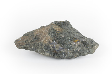
 The Beechworth Burke Museum
Geological specimen - Chalcopyrite
... Victoria that begun in 1852 (in response to the Gold Rush) to study and map the geology of Victoria. Collecting geological specimens was an important part of mapping and understanding the scientific makeup of the earth. Many of these specimens were sent to research and collecting organisations across Australia, including the Burke Museum, to educate and encourage further study. burke museum beechworth indigo shire beechworth museum geology geological specimen chalcopyrite copper pyrites copper mining tasmanian geology mount lyell mount lyell mines fools gold mohs scale crystals minerals historical geological collection victorian geological survey a.r.c selwyn gold rush van diemans land This hand sized solid mineral specimen has shades of brass-yellow with spots of iridescent green-black tarnish. ...This specimen originated from Mount Lyell on the west coast of Tasmania, where a large group of open cut and underground copper-silver-gold mines began operating in 1883. Between 1893-1994, the Mt Lyell Mining and Railway Company were responsible for operations. The Mt Lyell copper-gold mines produce some excellent crystallised specimens of chalcopyrite and other minerals. The deposits are generally considered to be of Cambrian volcanic origin, but there are indications of Devonian granitic influence on the ores, plus local remobilisation during Devonian deformation. Over 120 million tonnes of ore was produced from several workings, including the main Prince Lyell mine and the North Lyell mine, which was also of great importance. The Mount Lyell mines have a long history of human and environmental disasters, including the 1912 North Lyell fire that killed 42 miners, and two separate incidents in 2013 in which three people lost their lives. The environmental impacts from this complex of mines are extensive, with waste tailings and heavy metal contamination flowing directly into the King and Queen River catchments. In 1954, the eminent Australian historian, Geoffrey Blainey, published 'The Peaks of Lyell' which delves into the history of the 1912 North Mount Lyell Disaster.Chalcopyrite does not contain the most copper in its structure relative to other minerals, but it is the most important copper ore since it can be found in many localities and occurs in a variety of ore types. The brassy-yellow colours in Chalcopyrite mean it is often confused with pyrites and gold, leading to use of the term, "fool's gold." Chalcopyrite has been the primary ore of copper since smelting began five thousand years ago. This specimen is part of a larger collection of geological and mineral specimens collected from around Australia (and some parts of the world) and donated to the Burke Museum between 1868-1880. A large percentage of these specimens were collected in Victoria as part of the Geological Survey of Victoria that begun in 1852 (in response to the Gold Rush) to study and map the geology of Victoria. Collecting geological specimens was an important part of mapping and understanding the scientific makeup of the earth. Many of these specimens were sent to research and collecting organisations across Australia, including the Burke Museum, to educate and encourage further study.This hand sized solid mineral specimen has shades of brass-yellow with spots of iridescent green-black tarnish. Chalcopyrite is a copper iron sulphide mineral and a major ore of copper common in sulphide veins and disseminated in igneous rocks. Chalcopyrite has a hardness of 3.5-4 on the Mohs Scale. It is a member of the tetragonal crystal system and has metallic lustre and opaque transparency.burke museum, beechworth, indigo shire, beechworth museum, geology, geological specimen, chalcopyrite, copper pyrites, copper mining, tasmanian geology, mount lyell, mount lyell mines, fools gold, mohs scale, crystals, minerals, historical geological collection, victorian geological survey, a.r.c selwyn, gold rush, van diemans land -
 The Beechworth Burke Museum
Geological specimen - Mangan Hedenbergite
... Victoria that begun in 1852 (in response to the Gold Rush) to study and map the geology of Victoria. Collecting geological specimens was an important part of mapping and understanding the scientific makeup of the earth. Many of these specimens were sent to research and collecting organisations across Australia, including the Burke Museum, to educate and encourage further study. manganese open cut mine manganese ore processing Bell Bay Tasmania Northern Territory steel industry zinc-carbon batteries alkaline batteries tin cans A hand-sized mineral specimen in shades of silver and black Geological specimen Mangan Hedenbergite ...This specimen was recovered from Broken Hill, NSW. It was given the name Mangan Hedenbergite in 1819 by Jöns Jakob Berzelius in honor of Mr. Anders Ludvig of Hedenberg who was the first to define hedenbergite as a mineral. Hedenbergite, belongs in the pyroxene group having a monoclinic crystal system. The mineral is extremely rarely found as a pure substance. Mangan Hedenbergite is a manganese bearing variety of Hedenbergite. Manganese is the world’s fourth most used mineral after iron, aluminium, and copper primarily because it has no satisfactory substitute in its major applications. Globally, the steel industry is the primary user of manganese metal, utilizing it as an alloy to enhance the strength and workability of steel and in the manufacture of tin cans. Manganese is a key component of certain widely used aluminium alloys and, in oxide form, dry cell batteries used in electric vehicles. These batteries are in high demand. Another potential use for manganese may as an additive to help coat and protect a car’s engine. Manganese is also used for non-metallurgical purposes such as plant fertilizers, animal feed, and colorants for bricks. This specimen is part of a larger collection of geological and mineral specimens collected from around Australia (and some parts of the world) and donated to the Burke Museum between 1868-1880. A large percentage of these specimens were collected in Victoria as part of the Geological Survey of Victoria that begun in 1852 (in response to the Gold Rush) to study and map the geology of Victoria. Collecting geological specimens was an important part of mapping and understanding the scientific makeup of the earth. Many of these specimens were sent to research and collecting organisations across Australia, including the Burke Museum, to educate and encourage further study.A hand-sized mineral specimen in shades of silver and blackmanganese, open cut mine, manganese ore processing, bell bay, tasmania, northern territory, steel industry, zinc-carbon batteries, alkaline batteries, tin cans -
 The Beechworth Burke Museum
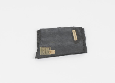
Geological specimen - Slate (Metamorphic), Unknown
... mine slate is Spain and parts of the United Kingdom. This specimen is part of a larger collection of geological and mineral specimens collected from around Australia (and some parts of the world) and donated to the Burke Museum between 1868-1880. A large percentage of these specimens were collected in Victoria as part of the Geological Survey of Victoria that begun in 1852 (in response to the Gold Rush) to study and map the geology of Victoria. ...This particular specimen was found in the Moorabool Slate quarries in Victoria. The Moorabool Slate quarries was established in the 1860’s by a company of Welshmen with a crew of six who purchased land by the riverside to mine for slate. Under the promise of adding to existing recourses the crew mined the slate which was used for paving and roofing. Slate is a fine-grained, low-grade metamorphic rock that is formed by the transformation of mudstone, shale or sometimes volcanic ash under low pressure and temperatures. It dark colour is due to carbonaceous material or to finely divided iron sulphide. It is believed that Evan Rowlands and Theophilus Williams of Ballarat were the first to discover the slate veins. Slate is a one of the most common natural stones in general use. Being used as paving, flooring, roofing and more. However, its history of being mined in Australia is not common as it is considered that the best places to mine slate is Spain and parts of the United Kingdom. This specimen is part of a larger collection of geological and mineral specimens collected from around Australia (and some parts of the world) and donated to the Burke Museum between 1868-1880. A large percentage of these specimens were collected in Victoria as part of the Geological Survey of Victoria that begun in 1852 (in response to the Gold Rush) to study and map the geology of Victoria. Collecting geological specimens was an important part of mapping and understanding the scientific makeup of the earth. Many of these specimens were sent to research and collecting organisations across Australia, including the Burke Museum, to educate and encourage further study.A somewhat rectangular foliated metamorphic rock composed of quartz, sericite and minerals from the chlorite group that make up the compounds of slate. The rock is dark grey almost black.Geological survey / R S / Loc Moorabool /Slate quarries / 1/4 sheet | 78 | Roofing Slate /burke museum, beechworth, geological, slate, metamorphic, slate (metamorphic), geological specimen, slate specimen, indigo shire -
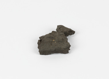 The Beechworth Burke Museum
Geological specimen - Brown Coal
... Mine intends to shut down permanently as of 2028. Soon after gold was discovered in 1851, Victoria’s Governor La Trobe wrote to the Colonial Office in London, urging ‘the propriety of selecting and appointing as Mineral Surveyor for this Colony a gentleman possessed of the requisite qualifications and acquaintance with geological science and phenomena’. Alfred Selwyn was appointed geological surveyor in Australia in 1852 which began the Geological Survey of Victoria. In 1853-69 the Geological Survey issued under Selwyn's direction sixty-one geological maps...Victoria that begun in 1852 (in response to the Gold Rush) to study and map the geology of Victoria. Collecting geological specimens was an important part of mapping and understanding the scientific makeup of the earth. Many of these specimens were sent to research and collecting organisations across Australia, including the Burke Museum, to educate and encourage further study. burke museum beechworth indigo shire beechworth museum geological geological specimen mineralogy yallourn yallourn mine victoria coal brown coal brown coal specimen Alfred Selwyn Geological Survey of Victoria Geological Survey Yallourn Power Station 13 / BROWN COAL / Showing Woody structure / Locality: Yallourn, Vic. | Label probably / correct but / can't find reference / no. 13 to match in / registers. / C Willman / 15/4/21 A solid hand-sized sedimentary rock that is a dark shade of brown. ...Brown Coal is typically found as rocks. During formation the Brown Coal starts as peats, which is an acidic brown deposit resembling soil, and over time when subjected to pressure and heat these peats form the Coal. Brown Coal is the lowest rank of coal as it has a low carbon (energy) content, and a high moisture content. This high moisture content makes Brown Coal unsuitable for overseas exports. This particular specimen was recovered from the Yallourn Mine in Latrobe Valley, Victoria as part of the geological survey of Victoria being carried out by Alfred Selwyn. Otherwise known as the 'Yallourn Power Station', the Yallourn Mine is Australia's second largest mine. Yallourn Mine was first built in 1920, and since then it has been providing over 1 billion tonnes of Brown Coal to Australia every year. The Yallourn Mine is responsible for 22% of Victoria's electricity and 8% of Australia's electricity. As of 2021 the mine employs around 500 people. Due to ongoing maintenance issues and Australia's move to cleaner energy, the Yallourn Mine intends to shut down permanently as of 2028. Soon after gold was discovered in 1851, Victoria’s Governor La Trobe wrote to the Colonial Office in London, urging ‘the propriety of selecting and appointing as Mineral Surveyor for this Colony a gentleman possessed of the requisite qualifications and acquaintance with geological science and phenomena’. Alfred Selwyn was appointed geological surveyor in Australia in 1852 which began the Geological Survey of Victoria. In 1853-69 the Geological Survey issued under Selwyn's direction sixty-one geological maps and numerous reports; they were of such high standard that a writer in the Quarterly Journal of the Geological Society of London bracketed the survey with that of the United States of America as the best in the world. During his years spent in Australia, Selwyn collected numerous significant geological specimens, examples of which are held in collections such as the Burke Museum.Brown coal is considered to be an essential rock to Australia's energy consumption. Although plentiful in sources, Brown Coal is not able to be exported overseas due to its high moisture content. As Australia moves towards cleaner energy, Brown Coal is going become less used. This specimen is part of a larger collection of geological and mineral specimens collected from around Australia (and some parts of the world) and donated to the Burke Museum between 1868-1880. A large percentage of these specimens were collected in Victoria as part of the Geological Survey of Victoria that begun in 1852 (in response to the Gold Rush) to study and map the geology of Victoria. Collecting geological specimens was an important part of mapping and understanding the scientific makeup of the earth. Many of these specimens were sent to research and collecting organisations across Australia, including the Burke Museum, to educate and encourage further study.A solid hand-sized sedimentary rock that is a dark shade of brown.13 / BROWN COAL / Showing Woody structure / Locality: Yallourn, Vic. | Label probably / correct but / can't find reference / no. 13 to match in / registers. / C Willman / 15/4/21burke museum, beechworth, indigo shire, beechworth museum, geological, geological specimen, mineralogy, yallourn, yallourn mine, victoria, coal, brown coal, brown coal specimen, alfred selwyn, geological survey of victoria, geological survey, yallourn power station