Showing 47 items matching "map of castlemaine"
-
 Ballarat Heritage Services
Booklet, Rev. C.G. Schmidt, The Lutheran Church in Castlemaine also Yandoit and Maldon, c1986
... ...map of castlemaine...Ballarat Heritage Services PO Box 2209 Bakery Hill Post Office goldfields castlemaine yandoit maldon lutheran church pastor munzel pastor leypoldt german australians map of castlemaine Eighteen page booklet on the Lutheran church in and around Castlemaine. ...Eighteen page booklet on the Lutheran church in and around Castlemaine. castlemaine, yandoit, maldon, lutheran church, pastor munzel, pastor leypoldt, german australians, map of castlemaine -
 Bendigo Historical Society Inc.
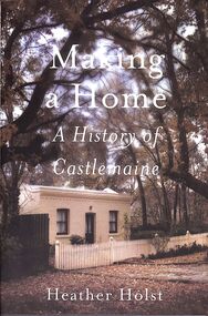
Book - "Making a Home. A History of Castlemaine", 2014
... of topographical map of Castlemaine. Title and author's name in white print on front cover. ... of topographical map of Castlemaine. Title and author's name in white print on front cover. ...The discovery of gold in Australia was a pivotal moment in the nation's history, leading to a series of gold rushes that transformed the Australian colonies. Victoria's goldrush began in Ballarat in 1851 and quickly spread to other parts of the state, including Castlemaine in July, drawing thousands of miners from around the world. The gold rush in Castlemaine began with the discovery of gold in July 1851, which attracted tens of thousands of migrants to the area. By 1852, the population on the Castlemaine Diggings had reached 30,000 people. The town was officially proclaimed a City on 4 December 1965, although it has since declined in population. The town's history is marked by its role in the Victorian gold rush, which was the world's richest shallow alluvial goldfield at its peak. The discovery of gold led to a significant increase in population and economic activity, transforming the area into a bustling town and a key settlement of the Mount Alexander diggings. "Making a Home. A History of Castlemaine" by Heather Holst. Discusses the history of the town including Aboriginal history, women's experiences, welfare, charity, and home economics. Soft cover. Published in Australia by Australian Scholarly Publications in 2014. Front cover features a white brick cottage surrounded by trees, behind fence. Back cover and spine feature map of topographical map of Castlemaine. Title and author's name in white print on front cover. Book includes black and white images. Contains index. 262 pp. ISBN 7981925003406.goldfields, miners, castlemaine, friends of the mount alexander diggings -
 Bendigo Historical Society Inc.
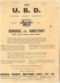
Booklet - The Universal Business Directory (UBD)
... The directory includes classified sections for Bendigo and surrounding towns, including Carisbrook, Castlemaine, Eppalock, Harcourt, Malmsbury, Maryborough, Newbridge, Raywood, Tooborac and Yapeen. It also includes an Eaglehawk Traders section, emergency phone numbers and maps of Bendigo, Castlemaine, Kangaroo Flat and Maryborough. ...It also includes an Eaglehawk Traders section, emergency phone numbers and maps of Bendigo, Castlemaine, Kangaroo Flat and Maryborough. ...The Nineteenth Edition of the Bendigo and Districts Universal Business Directory, which is Section 3 of the Victorian Country Directory for 1969. The directory includes classified sections for Bendigo and surrounding towns, including Carisbrook, Castlemaine, Eppalock, Harcourt, Malmsbury, Maryborough, Newbridge, Raywood, Tooborac and Yapeen. It also includes an Eaglehawk Traders section, emergency phone numbers and maps of Bendigo, Castlemaine, Kangaroo Flat and Maryborough. The booklet is made of soft flimsy paper with black print and contains 51 pages.There is a grey lead scribble on back page between the '6' and '7'.bendigo businesses, bendigo maps, 1960s, bendigo business directory -
Federation University Historical Collection
Document, Zelda Martin, Central Victorian Goldmining towns - Boom Towns or Ghost Towns?, c1996
... *Three articles published by Buninyong and District Historical Society Inc: (Magpie Exploration; Finding Gold In The Green Hills; Magpie Exploration; Burnt Bridge to Cargarie to Mt Mercer) *Copies of newspaper articles/items *Buninyong Street Directory Carisbrook: *In the Beginning There Was Carisbrook *The History of the Carisbrook Racecourse Carngham / Snake Valley: *Brief History *Directory Castlemaine: *Directory 1865-1866 - Alphabetical and Street *Poster - Castlemaine A Contemporary Guide "The Great Centre" 1866 - A Contemporary Guide to the Fascinating Past *Pamphlet - Castlemaine District Community Hospital *Map - Castlemaine, Maldon & Surrounding Districts *Map and Information - The Dry Diggings Track - a 55kl walk among historic goldfields relics ( Castlemaine Fryerstown Vaughan Mt Franklin Hepburn Daylesford) *Postcard - Former Court House *Directory 1867 - Alphabetical, Trade [.10] Resource No.3 Grey folder Titled Towns 3 Creswick to Maryborough Creswick: *Brief History *Booklet - "Creswick Cemetery Walk" *Booklet - The Buried Rivers of Gold Heritage Trail Creswick *Creswick Historical Museum Information Sheet *Chronological History of Creswick *Alphabetical Directory of the Borough of Creswick *Creswick's Creek Directory 1856 *Historic Creswick Walking Tour *A Brief Account of the Schools of Creswick - Past and Present *100 Years of Railway Travel in Creswick *The Berry Deep Leads *The Spence Home at Jackass Gully in the Creswick State Forest ( William Guthrie Spence - Pioneer) *The New Australian Mine and the 1882 Disaster *Creswick District News, Issue 7, July August 1999 *The Creswick Miners Walk - Information and Map *Maps Chewton: *Brief History *Directory Clunes: *Brief History *Clunes Street Directory Daylesford: *Brief History *Notable Bushfires in Daylesford District Over More Than a Century - "Black Thursday" 1851; 1862; 1899; the Disastrous Hepburn Fire of 1906; 1939; 1944; 1969. ...*Three articles published by Buninyong and District Historical Society Inc: (Magpie Exploration; Finding Gold In The Green Hills; Magpie Exploration; Burnt Bridge to Cargarie to Mt Mercer) *Copies of newspaper articles/items *Buninyong Street Directory Carisbrook: *In the Beginning There Was Carisbrook *The History of the Carisbrook Racecourse Carngham / Snake Valley: *Brief History *Directory Castlemaine: *Directory 1865-1866 - Alphabetical and Street *Poster - Castlemaine A Contemporary Guide "The Great Centre" 1866 - A Contemporary Guide to the Fascinating Past *Pamphlet - Castlemaine District Community Hospital *Map - Castlemaine, Maldon & Surrounding Districts *Map and Information - The Dry Diggings Track - a 55kl walk among historic goldfields relics ( Castlemaine Fryerstown Vaughan Mt Franklin Hepburn Daylesford) *Postcard - Former Court House *Directory 1867 - Alphabetical, Trade [.10] Resource No.3 Grey folder Titled Towns 3 Creswick to Maryborough Creswick: *Brief History *Booklet - "Creswick Cemetery Walk" *Booklet - The Buried Rivers of Gold Heritage Trail Creswick *Creswick Historical Museum Information Sheet *Chronological History of Creswick *Alphabetical Directory of the Borough of Creswick *Creswick's Creek Directory 1856 *Historic Creswick Walking Tour *A Brief Account of the Schools of Creswick - Past and Present *100 Years of Railway Travel in Creswick *The Berry Deep Leads *The Spence Home at Jackass Gully in the Creswick State Forest ( William Guthrie Spence - Pioneer) *The New Australian Mine and the 1882 Disaster *Creswick District News, Issue 7, July August 1999 *The Creswick Miners Walk - Information and Map *Maps Chewton: *Brief History *Directory Clunes: *Brief History *Clunes Street Directory Daylesford: *Brief History *Notable Bushfires in Daylesford District Over More Than a Century - "Black Thursday" 1851; 1862; 1899; the Disastrous Hepburn Fire of 1906; 1939; 1944; 1969. ...Zelda Martin was a PhD candidate at the University of Melbourne.[.1] 4th item in light blue display book titled Research Approach/Overview of Chapters/Confirmation of Canditure/Chapters1,2,3&4 of proposed thesis. *Twenty-seven page article on Victorian goldfields towns titled: Central Victorian Goldmining Towns - Boom Towns or Ghost Towns. The article was written during the author's PhD study. It outlines the context methodology, and resources and the chapters of the proposed thesis: (1) Central Victorian Goldmining Towns - The Context (2) Contemporary Views of the Factors Necessary for Town Growth (3) Outward Manifestations of Town Growth (4) The Trappings of Government (5-9) The Main Towns and Their Hinterland. [.2] 5th item in Light Blue display book as above item. *Chapter 1 of proposed thesis titled 'Pick, Shovel and Tin Dish Mining.' Covers in Section A: Central Victoria - Pre 1851: Aborigines in Central Victoria, Squatters, and Government. Section B: The years 1851-1854: The Early Gold Rushes, Government Reaction, Township Surveys, Legislation, Town Development, Local Government and Early Settlement. [.3] 6th item in Light Blue display book as above item. *2A of proposed thesis titled 'Contemporary Views of the Factors Necessary for Town Growth'. Similar information to Chapter 1 plus extra re towns and maps. Sections: Introduction, Context of Place - Geographical Towns Listed, The Context of Time - Pre1851 Aborigines, Governance of Port Phillip, The Squatters, The Villages of Central Victorian Highlands, Conclusion, Condensed Version of Chapter2B. [.4] 7th item in Light Blue display book as above item. *Chapter2B of proposed thesis. Sections: Area of Research, Schools, Banks, Newspapers, Progress Association, Town Development - Sandhurst (Bendigo), Ballarat, Castlemaine,, Maryborough, Ararat and Stawell. [.5] 8th item in Light Blue display book as above item. *Chapter 3 of proposed thesis titled 'Outward Manifestations of Town Growth'. Sections: Introduction, Contemporary Writing, Educationalists, The Bankers, The Townsfolk, Current Theory, General Theories of Urban Development, and Conclusion. [.6] 9th item in Light Blue display book as above item. *Chapter 4 of proposed thesis titled 'Trappings of Government' Sections: Introduction, Early Government Attitudes to Mining and Town Development, Law and Order, Township Surveys, Legislation, Local Government, Transport and Communication, The People and Lobbyists. [.7] 10th item in Light Blue display book as above item. *'The Rise and Fall of Central Victorian Goldmining Towns'. Includes a map showing main Goldfields, a table showing towns and villages at two points in time - 1857 and 1871; a Bibliography of Primary and Secondary Sources. [.8] Resource No1. Black display book titled Local Towns 1 : Alma: *Brief history *Directory *Maps Amphitheatre / Mountain Hut: *Brief History Post Office Directory Ararat: *Brief History *Post Office Directory 1869 - Alphabetical Listing by Occupation *Ararat - Prominent Citizens of 1858 *Langi-Morgala Museum Avoca: *Brief History *Excerpts from 'Avoca The Early Years', Margery and Betty Beavis; pg1 - Beginnings; pg11 - The Midas Touch; pg25 - Local Gold Escorts; pg27 - A Town is Born; pg51- The Administration of Justice; pg53 - The Ways of the Law; pg61 - News of the Day; pg65 - A Time to Play; pg72 - Land Ownership *Post Office Directory (Bailliere's) 1869 *Tourism Map and Information of area *Historic Avoca - A 5.5km Tour *Avoca & the Pyrenees Region - information pamphlet Ballarat: *Early History of Ballarat - Ballarat Historical Society, Publication No.1: origin of the name; Ballaarat - the Beginning; Fabulous Yields from the Ballaarat Goldfield; *Streetscape Lydiard Street. *Hand drawn map showing Leigh River, Old Portland Bay Road, plaque on road to Colac; etc. *Newspaper article re 'The Theatre Royal' ( which stood in the vicinity of the current Owen Williams store) - 'The News'15/04/1998 *Article - 'Ballarat's Mechanics' Institute Lives On' Ballarat Courier, 14/09/1985 *Article - Standing the Test of Time' The News 17/11/1993 re The Mechanics Institute & picture of the Reading Room *'Ballarat a Study of a City, Phyllis Reichl, pub. Nelson, 1968; no.3 place, time and people field studies series *Investigator Vol.33 No.2, 1998 Geelong Historical Society. Article on pg75 describes Ballarat in 1861 *Folded poster - 'Ballarat 100' a history of telegraph communication, pub. Telecom. Beaufort (Fiery Creek): *Brief history *Post Office Directory [.9] Resource No.2 Black Folder Titled Towns cont.No2 Bendigo (Sandhurst): *'Family & Local History at the Bendigo Library - 1851-2001 150 years of gold'. *Bendigo Government Camp in 1853 illustration; key to sketch and names of Government officers stationed there *Excerpts from 'Bendigo and Vicinity' Adolph Haman *The Bendigo Goldfield Registry - pgs 1-7 Introduction *Excerpt: 'Breaking the Grip' *Excerpt: The Most Go-Ahead Place *Excerpts from 'History of Bendigo' - anti license agitation; laying out of town; proposed railway; gold calls and dividends; the Sandhurst Municipality; journalism *Bibliography Blackwood: *Excerpts from 'Aspects of Early Blackwood - The Goldfield, the Landmarks, the Pioneers' Alan J Buckingham and Margaret F Hitchcock, JG Publishing,1980 Buninyong: *A Brief History *Investigator Vol1 No.2 Feb 1966 Geelong Historical Society. Pg3 - Article re gold escort route - Mt Alexander to Adelaide - (see a simple monument on the Western Highway a few miles out of Horsham. Pg 15 - Ballarat Excursion - re the finding of gold. *Three articles published by Buninyong and District Historical Society Inc: (Magpie Exploration; Finding Gold In The Green Hills; Magpie Exploration; Burnt Bridge to Cargarie to Mt Mercer) *Copies of newspaper articles/items *Buninyong Street Directory Carisbrook: *In the Beginning There Was Carisbrook *The History of the Carisbrook Racecourse Carngham / Snake Valley: *Brief History *Directory Castlemaine: *Directory 1865-1866 - Alphabetical and Street *Poster - Castlemaine A Contemporary Guide "The Great Centre" 1866 - A Contemporary Guide to the Fascinating Past *Pamphlet - Castlemaine District Community Hospital *Map - Castlemaine, Maldon & Surrounding Districts *Map and Information - The Dry Diggings Track - a 55kl walk among historic goldfields relics ( Castlemaine Fryerstown Vaughan Mt Franklin Hepburn Daylesford) *Postcard - Former Court House *Directory 1867 - Alphabetical, Trade [.10] Resource No.3 Grey folder Titled Towns 3 Creswick to Maryborough Creswick: *Brief History *Booklet - "Creswick Cemetery Walk" *Booklet - The Buried Rivers of Gold Heritage Trail Creswick *Creswick Historical Museum Information Sheet *Chronological History of Creswick *Alphabetical Directory of the Borough of Creswick *Creswick's Creek Directory 1856 *Historic Creswick Walking Tour *A Brief Account of the Schools of Creswick - Past and Present *100 Years of Railway Travel in Creswick *The Berry Deep Leads *The Spence Home at Jackass Gully in the Creswick State Forest ( William Guthrie Spence - Pioneer) *The New Australian Mine and the 1882 Disaster *Creswick District News, Issue 7, July August 1999 *The Creswick Miners Walk - Information and Map *Maps Chewton: *Brief History *Directory Clunes: *Brief History *Clunes Street Directory Daylesford: *Brief History *Notable Bushfires in Daylesford District Over More Than a Century - "Black Thursday" 1851; 1862; 1899; the Disastrous Hepburn Fire of 1906; 1939; 1944; 1969. *Post Office Directory -Daylesford and Hepburn Dunolly / Inkerman: *Brief History *Directory *Pamphlet - Goldfields Historical Museum *Pamphlet - Historic Dunolly - Victoria's Best Kept Secret *Map of Gold Workings at Dunolly Area - showing where the main gold rushes occurred *Brief History - Inglewood *Directory - Inglewood - Name Occupation, Dwelling Kingower: *Brief History *Directory - Name / Ocupation / Dwelling Linton / Happy Valley / Piggoreet: *Brief History *Directory - Lintons McIvor: *"A History of the Shire and the Township of Heathcote" by J.O. Randell Majorca: *Brief History *Official Post Office Directory 1869 - Name / Occupation/ Address Maldon (Tarrangower): *Brief History Part 1 *Brief History Part 2 *Post Office Directory *List - Alphabetical Order by Names plus Business and Trade (Tarrangower Times Oct/1858) *List - Alphabetical Order by Trade plus Name and Business *Directory - Name / Occupation / Dwelling Maryborough: *Worsley Cottage - built by Arthur Worsley, a contractor in stonework in 1894 [.11] Resource No. 4 Blue Display Book titled Towns 4 Moliagul to Stawell Moliagul: *Brief History *Moligul Legislative Assembly (Voting?) List - Names and Occupations *Moliagul Victorian Post Office Directory 1868 - Name / Ocupation / Address / Comments *"The Welcome Stranger" gold nugget *The Sunday School *The Welcome Stranger Discovery Walk - information and map Moonambel (Mountain Creek) Redbank *Brief History *List of names extracted from advertisments of the Pioneer and Mountain Creek Advertiser 16/02/1861. *Bailliere's Directory 1869 - Alphabetical List of Name / Occupation / Place St Arnaud: *Brief History Sebastapol: *Brief History *Directory 1869 - Alphabetical by Name; plus occupation and address. Browns and Scarsdale: *Brief History *Browns Street Directory - Name and Occupation Smythesdale: *Brief Description *Smythesdale Street Directory -Name and Occupation Stawell (Pleasant Creek) *Brief History *Victorian Official Post Office Directory - Name /Occupation / Dwelling *Chronology - 1841-1920 *Production of gold statistics - 1879 - 1900 *Big Hill *Extracts from "The Golden Years of Stawell". Chapt 1 - Stawell's Coming Out. Capt. 2 - The Gold Rush. Caapt.3 - Cradle of Democracy. Chapt.4 - The Reefs Becomes Stawell. Chapt. 5 - Rushing In. Chapt.6 - The Pioneers. Chapt 7 - The Decade of Optimism. [.12] Resource No. 5: Blue Display Book titled 'Towns Steiglitz to the The Golden Triangle. Steiglitz: Brief History Victorian Post Office Directory 1869 *Map of Steiglitz *List of maps relevant to Steiglitz history *Information 6 tables of data from "Reports of Mining Surveyors Talbot (Back Creek) Brief History Taradale: Post office Directory 1869 - Name/Occupation/Street. Also list in alphabetical order by Occupation Taradale *Chronological Reference to Taradale Mines *Water - The Coliban System of Waterworks *Joseph Brady *The Syphon Tarnagulla (Sandy Creek) *Brief History *Tarnagulla Businessmen Cameos to give depth to advertisments in 'The Tarnagulla Courier' various issues 1864-1871 *Directory - Name/Occupation /Address *List - Name/Business/Trade Wedderburn (Koorong) *Brief History *List - Name/Occupation The Golden Triangle: *The Early Rushes - Wedderburn / Moliagul / Sandy Creek - Tarnagulla / Jones Creek - Waanyarra / Kingower / Dunolly - Goldsborough / Inglweood *Census of 1857 - Population / Occupations *1858-1871 - A Time of Consolidation- Wedderburn / Moliagul / Sandy Creek- Tarnagulla / Arnold *Census 1871 - Population *Information gleaned from the census data - Demographics / Population / Occupations / marital / Birthplace / Religion / Literacy/ Occupation and Housing Cameos *Graphs - Birthplace of settlers /Male-Female Ratio / Married males / Children under 15 as Percentage of Population / Religion *Census 1857 - Statistical data *Maps *Bibliography [.13] Resource No. 6 - Black Display Book Information and Research in Central Victoria including: *Banking - Research from ANZ Bank Archives *Institutions - also includes articles listed from the Ballarat Times Newspaper *Australian mining History Association - A.M.H.A. Bibliography *Australia's Mining History * Bibliography - Land Surveys Victoria - *1853 Administration (Statistics and Other) includes: schools / ministers of religion / police / military / local administration / licences for sale of spirits / distances between various Victorian gold fields. * Victoria Government Gazette (Copy) - N0. 116, 12/12/1854 includes: Gold Felds Commission of Enquiry & No. 85, 15/09/1854 - Addresses presented to the Lieutenant Governor (Sir Charles Hotham) during his tour through the Gold Fields of Victoria,1854. Addresses on behalf of : the people of Bendigo; Members of the Church of England, Bendigo; Members of the Wesleyan Church on the Bendigo Gold Fields; Bendigo Gold District General Hospital; the Bendigo Prospecting Association; Committee of the Bendigo Local Exhibition; Bendigo District Medical Association; Coloured Americans Resident at Bendigo; German Inhabitants of Bendigo; Landowners, Inhabitants, and Miners of Castlemaine; Inhabitants of Forest Creek; Inhabitants of Heathcote and Gold Miners of McIvor; Residents and landholders of the District of Bacchus Marsh; Inhabitants of Kilmore and Vicinity. *Gold Fields Correspondence 1853: letter from Lieutenant Colonel Valiant, (Officer commanding the Troops in Victoria) to the Lieutenant Governor re threatened disturbance at Sandhurst (Bendigo) regarding the Gold License Fee. * Extracts from a book "Victoria" re Gold Fields Commission of Enquiry involving mainly Ballarat and Castlemaine and a chapter titled 'A Tour to the Victorian Gold-Fields' *Lists of central Victorian newspapers - listed by date published 1851to 1874; by first date available to State Library. *A list of cities and towns showing County, population in 1861 &1871, and municipal status. [.14] Resource no.7. Black display book. *Reference: Papers presented to Parliament Victoria - 1859-1860 4 volumes - relevant sections copied. Contains information on Branches of Government. General / Finance / Gold / Gazette / Commission and Warrant / Statistic. *Gold Fields Act. In accordance with the Act the gold fields are divided into six districts - Ballaarat, Castlemaine , Sandhurst, Avoca, Ararat, and Beechworth.. Official staff in each gold district consists of a Resident Warden, Wardens, Wardens' Clerks, Bailiffs, Chinese Protectors, Chinese Interpreters, and Mining Surveyors. *Gold Receiver *Gaols *Police magistrates and Clerks of Petty Sessions, etc. *Field Branch *Immigration and Emigration Overland - Chinese - 1859 *Population on the Goldfields *The Geological Survey - The Government Geologist is assisited by staff from four branches - the office Branch; the Publishing Branch; the Field Branch and the Museum Branch. *Commission to Enquire Into Sludge dated 10/02/1859 (Some sections copied) - Report to the Honorable Chief Commissioner of Public Works, Melbourne re the mode of carrying the sludge from the puddling mills in Sandhurst without interfering with the drainage of the town and the roads in the neighbourhood. [.15] Resource No.8: Camel display book titled Resource No. 8. Aborigines *Lists of book titles - +"Readings in Victorian prehistory" +"The Aborigines of Port Phillip" +Aboriginal languages and clans" +"A History of the Port Phillip District" +"Langi Ghiran 1: Aboriginal Rock...." +"Koorie History: sources for aboriginal studies in the State Library of Victoria", ed. Tom Griffiths, Melb. Friends of the State Library, 1989 +"The Public Lands of Australia Felix"; settlement and land appraisal in Victoria1834-91 with special reference to the Western Plains", J.M.Powell, Melb. Oxford University Press 1970 +*Bibliography of the Victorian Aborigines' from the earliest manuscripts to 31st December 1970, Massoa, Aldo, Melb. Hawthorn Press, 1971 +"Aborigines in Colonial Victoria, 1836-1886", M.F. Christie, Sydney University Press, 1979 +"Urban and Industrial Australia: readings in Human Geography" ed J.M. Powell, Melb. Sorrett Pub. 1974 *Extracts: -Processes of Pioneer Settlement - The Squatting Occupation of Victoria, 1834-60. J.M. Powell -Areal Variations in the Class Structure of the Central-Place Hierarchy. P. Scott - Volume1 and Volume 2: Notes Relating to the Habits of the Natives of Other Parts of Australia and Tasmania. Compiled from various sources for the Government of Victoria by R Brough Smyth. John Curry, O'Neil, Melb. 1st pub. Melb. 1876. p31-45 - Numbers and Distribution of the Aborigines in Victoria -Victorian Aborigines 1835-1901 - A Resource Guide to the Holdings of the Public Record Office, Victoria; published by the Government Information Centre 1984. *History of the Aboriginal Artefacts Displayed in the Daylesford Museum. F. G. Powell (4 page pamphlet) *Letter to Zelda Martin from Peter Lovett, Cultural Officer, Ballarat & District Aboriginal Co- Operative, 05/02/1997 *Map: Ian Clarke Victorian Tribunal Boundary Map - Clans of Central Victoria. *Victorian Rock Art and Mythology - Article about Mount Langhi Ghiran and myths of the Tjapwarong people. *Two Aboriginal myths relating to the Grampians - 'The Monster Emu' / 'The Aquisition of Fire', by the Aborigines in the Grampians Areas *Article titled (chapter 8) Ballarat - information re camping sites in the region. Lake Wendouree / Lake Burrumbeet (includes a myth) / Mt Bunninyong / Lal Lal / Pitfield / Mount Elephant / Mount Egerton / Meredith / Lake Goldsmith / Lake Learmonth / Ercildoune *Notes on the Aborigines of the Wider Ballarat Region plus European names=Aboriginal names. John Morris 26/07/1995 *Role of Aborigines in Town Development in Central Victoria. Mentions Native Police Force est. in Port Phillip 1842 and Central Board for Aborigines est. 1860 *The Grave of King Billy. (Frank Wilson) Pamphlet. *Camping Places in Central and Northern Victoria. Article re Lake Burrumbeet site. *Programme for the Unveiling of Memorial Cairn for Edward Stone Parker 1802-1865. Note portrait not accurate. Accurate portrait is available in the book "A Successful Failure A Trilogy The Aborigines and Early Settlers", Edgar Morrison, Graffiti Publications, 2002. * Large envelope addressed to Mr G Netherway containing newspaper cuttings regarding the life of Edward Stone Parker, the unveiling of the Memorial Cairn as mentioned above, articles titled 'Episodes from Our Early Days' (Edgar Morrison, Yandoit)- The Black's School, A School At Last and The Final years. Also a typed page titled 'Historical Background to E.S.Parker's Career. Includes an interesting tale titled 'When the cat lay doggo' re laying power leads for the unveiling ceremony at the memorial site. [.16] green display folder titled 'Research Aids' *List of references to Commissioners' & W'ardens' Reports (formerly held at La Trobe Library Archives, now at Public Records Office [PRO]). Indicates town referred to / date of report / name of camp if different to town. * Archive information re Anglican Records *Movement around the Goldfields - Miners and Storekeepers - usefulness of newspapers in providing information - areas covered - Castlemaine, Maldon, Ararat, Stawell, Tarnagulla, Dunolly. *Port Phillip /Victoria Directories 1839/1867 - Chronological list of Directories included in this series. *"Notes on the History of Local Government in Victoria" A.W. Greig Melb. University Press 1925 - Photo-copied extract p5-p40. (Source - Deakin University Library) - Introduction by W.Harrison Moore. Section 1 - Development in New South Wales Before Separation. Section 2 - Development in Victoria After Its Separation from New South Wales. Hand written notations: 'roads, markets, and local government 1855 on' ;'opportunity of squatters in parliament' and 'opportunities of matters in parliament p33' * Notes on the Establishment of Surveyor General's Department 1851and Commissioner of Crown Lands and Survey. * Newspaper articles from The Argus, 1849, re the discovery of gold in the Pyrenees region. * Excerpt - a report on schools - A.B.Orlebar, Inspector; re the need for permanent school buildings rather than tents. *Excerpt from - 'Approaches to Urban History', Sean Glynn: The Case for Caution * Except from - 'The Urban Sprinkle', Weston Bate: Country Towns and Australian Regional History *Reference- 'The History of Land Tenure in the Colony of Victoria', John Quick. References the Haines Land Bill, land tenure and Land Leagues. [.17] Light blue envelope folder titled 'Birtchnell's Ballarat, etc. Directory 1862 *Contains various directories for Smythesdale, Buninyong, Clunes, Brown's and Creswick. [.18] Red envelope folder no.2 titled Victorian Gazetteer *Selected pages from 1869 Victorian Gazetteer on A4 paper (with a handwritten note questioning if some pages are from 1868 Victorian Gazetteer as appears to be different sizes - A3 pages.) Information includes locations and descriptions of towns, hotels, banks, communications and populations. (Does not include names, residences and occupations) [.19] Red Envelope folder titled Bailliere's Official Post Office Directory 1868 (or1869 or a mixture of both?) *Preface *Contains a selection of pages of towns highlighted in yellow in the the index *Work on this directory was commenced in 1867. *Information includes: Municipalities - mayors and councilors; lists of towns naming male inhabitants and their occupations. [.20]Yellow manila folder titled Post Grad Seminar Presentation 1996 *Gives some background to Zelda Martin's proposed thesis and why she chose the topic Gold Mining Towns Boom or Bust [.21] A3 display book - No. 1A * A list of 'Relevant Newspapers collected: The Tarrangower Times and Maldon Advertiser (first published 1858) Includes dates 1858-1867. The Mount Alexander Mail. Includes dates 1854-1866 The Tarnagulla Courier. Includes dates from1864-1871 Dunolly and Burnt Creek Express. Includes dates from 1862-1871 * Selection of newspaper pages from The Mount Alexander Mail 1854 to 1856, mostly showing advertisements for businesses and services provided to that community. [.22] A3 display book - No. 1B * Selection of newspaper pages from The Mount Alexander Mail 1857 to 1866, mostly showing advertisements for businesses and services provided to that community. [.23] A3 display book -No. 2 * Selection of newspaper pages from The Tarnagulla Courier 1864 to 1871, mostly showing advertisements for businesses and services provided to that community. [.24] A3 display book - No. 3 *Selection of newspaper pages from The Tarrangower Times (and Maldon and Newstead) Advertiser 1858 to1867, mostly showing advertisements for businesses and services provided to that community. [.25] A3 display book - No.4 * Selection of newspaper pages from The Dunolly and Burnt Creek Express; and The Dunolly and Betbetshire Express 1862 to 1871, mostly showing advertisements for businesses and services provided for that community. [.26] A3 display book - No.5 Includes: * Bryce Ross's Diggings Directory. Includes instructions for using this directory. This directory was used by "all persons having connexion or desiring to communicate with 'working parties, private friends, or Stores at the Diggings." As a directory for each area wwas completed it was published in each month's issue of Bonwick's "Digger's Magazine." Years c1852/1853. This Directory commences first at the head of Forest Creek. Includes a directory for Bendigo and Ballarat. Of interest at the end of the Bendigo and Ballarat directory is a list of the number of storekeepers, butchers, doctors, smiths, eating houses, lemonade sellers and chapels. * The Castlemaine Directory and Book of General Information Comprehending Glass's Model Calendar for the Two Years 1862 and1863. "zelda martin, victorian goldfield towns, bendigo, castlemaine, ballarat, maldon, stawell, ararat, maryborough, creswick, avoca, heathcote, banks, bank of australasia, union bank of australia, government camp, sandhurst, water supply, tarnagulla, talbot, back creek, mountain creek, police court, carisbrook, dunolly, thompson's foundry, charles clacy, anthony trollope, robert cecil, mount alexander, urbanisation, national schools, education, govenrment, industry, railway, transport, settlement, land settlement in central victoria, steiglitz, joseph brady, the new australian mine, berry deep leads, william guthrie spence, creswick state forest, arthur worsley, worsley cottage, the welcome stranger, moliagul, moonambel, redbank, st arnaud, sebastapol, brown's, scarsdale, clunes, chewton, daylesford, bushfires, inkerman, inglewood, kingower, lintons, happy valley, piggoreet, mcivor, majorca, tarrangower, taradale, the coliban system, the syphon, sandy creek, wedderburn, koorong, arnold, jones creek, waanyarra, the golden triangle, census 1857, blackwood, buninyong, durham lead, magpie, carngham, snake valley, alma, amherst, daisy hill, amphitheatre, mountain hut, beaufort, fiery creek, counties, population, gold fields commission of enquiry1854, william westgarth, gold license fee, lieutenant colonel valiant, administration of the victorian gold fields, commission to enquire into sludge 1859, e.s. parker, edward stone parker, edgar morrison, mount franklin protectorate, dja dja wurrung, memorial cairn, franklinford, mt franklin memorial cairn, jajowurrong, dja dja wurung, tjaowarong, wothowurong, assistant protectors, daylesford museum, buluk, rock art - grampians, aboriginal mythology - grampians, aborigines, first nations people, mount franklin, aboriginal artifacts, lake burrumbeet, native police force, central board of aborigines, yandoit, commissioners' reports, wardens' reports, port phillip/victoria directories 1839-1867, local government - victoria 1853/1854, surveyor general's department - 1850's, victorian schools 1850's, a.b.orlebar, haines land bill, william charles haines, wilson gray, land tenure, land leagues, victorian gazetteer, the tarrangower times and maldon advertiser - 1858-1867, the mount alexander mail 1854-1866, the tarnagulla courier 1864, dunolly and burnt creek express 1862-1871, bryce rose's diggings directory, the castlemaine directory 1862-1863 -
 Bendigo Military Museum
Map - TRENCH MAP, FRANCE WW1, FRAMED
... Refer 1634P for the story on the map. documents - maps frame accessories military history - army Top middle: France. RHS bottom rear: The Union Studio - Castlemaine sticker. ...Belonged to JOHN WILLIAM GRINTON No 1043 C Coy 38th Batt AIF. Refer Reg No 1280 for Service Details also 1317P, 1319P. Refer 1634P for the story on the map.Trench map of France - Edition 5A Bellicourt - Montbrahain - Bran Court. Tan, wooden frame, glass front with white cardboard backing. Hanging wire attached at back with centre strengthening brace. Map stuck on white background. German trenches in blue. Top middle: France. RHS bottom rear: The Union Studio - Castlemaine sticker.documents - maps, frame accessories, military history - army -
 Bendigo Historical Society Inc.
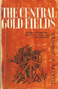
Book - THE CENTRAL GOLD FIELDS, c1969
... Castlemaine and neighbourhood. Publisher Cypress Books, printed by Cambridge Press, Melbourne. 80 pages. Photographs, illustrations and maps. ...Castlemaine and neighbourhood. Publisher Cypress Books, printed by Cambridge Press, Melbourne. 80 pages. Photographs, illustrations and maps. ...The Central Goldfields, Historical Backgrounds Bendigo, Castlemaine and neighbourhood. Publisher Cypress Books, printed by Cambridge Press, Melbourne. 80 pages. Photographs, illustrations and maps. Inscriptions: $1.20, Bendigo Historical Society. With IndexHarley W Forsterhistory, mining, central goldfields, harley w forster -
 Bendigo Historical Society Inc.
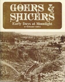
Book - GOERS AND SHICERS EARLY DAYS AT MOONLIGHT
... Goers and Shicers - Early Days at Moonlight Story of Lewis family on Castlemaine goldfields. 66 pages, with photographs, illustrations, maps....History House 11 Mackenzie Street Bendigo goldfields CASTLEMAINE Gold lewis family ISBN 0959453008 Margaret Temple Goers and Shicers - Early Days at Moonlight Story of Lewis family on Castlemaine goldfields. 66 pages, with photographs, illustrations, maps. Book GOERS AND SHICERS EARLY DAYS AT MOONLIGHT ...Goers and Shicers - Early Days at Moonlight Story of Lewis family on Castlemaine goldfields. 66 pages, with photographs, illustrations, maps.Margaret Templecastlemaine, gold, lewis family, isbn 0959453008 -
 Bendigo Historical Society Inc.
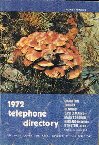
Book - BOOK - 1972 TELEPHONE DIRECTORY
... Castlemaine, Maryborough, Kerang Districts, Kyneton area. The book is blue with a unique pattern and has a picture of the local flora.The back cover features of a map of the Bendigo Area....Castlemaine, Maryborough, Kerang Districts, Kyneton area. The book is blue with a unique pattern and has a picture of the local flora.The back cover features of a map of the Bendigo Area. ...A copy of the 1972 Telephone Directy for Charlton, Echuca, Bendigo, Castlemaine, Maryborough, Kerang Districts, Kyneton area. The book is blue with a unique pattern and has a picture of the local flora.The back cover features of a map of the Bendigo Area.book, rural -
 Bendigo Historical Society Inc.
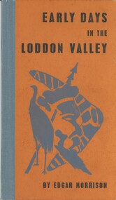
Book - EARLY DAYS IN THE LODDON VALLEY, 1966
... History House 11 Mackenzie Street Bendigo goldfields HISTORY Australian loddon valley History of Loddon Valley Castlemaine Daylesford Edward Stone Parker Aborigines Aboriginal Stations Edgar Morrison Early days in the Loddon Valley, Memoirs of Edward Stone Parker 1802-1865, 98 Pages, with photographs and maps, Limited Edition of 1000 copies, Book EARLY DAYS IN THE LODDON VALLEY ...Early days in the Loddon Valley, Memoirs of Edward Stone Parker 1802-1865, 98 Pages, with photographs and maps, Limited Edition of 1000 copies,Edgar Morrisonhistory, australian, loddon valley, history of loddon valley, castlemaine, daylesford, edward stone parker, aborigines, aboriginal stations -
 Bendigo Historical Society Inc.
Book - The Mystery Medal. A Tale of Crime and Compassion. Castlemaine Goldfields 1889, Lynne Cooper, 2024
... map of Victoria outline in background. Illustrated with black and white and coloured photographs. 98 pp. Book The Mystery Medal. A Tale of Crime and Compassion. Castlemaine ...Biography of Henry William Frood who served 32 years as a member of the Victorian Police Force. Written by his great granddaughter Lynne Cooper. Soft cover book. Red soft cover with images of two sides of a gold coloured medal. map of Victoria outline in background. Illustrated with black and white and coloured photographs. 98 pp. Hand written on the Dedication page in gold coloured texta "Lynne Cooper Bendigo 2024 Available from: Goldfields Library & The Golden dragon Museum".henry william frood, chinese, medals -
 Bendigo Historical Society Inc.
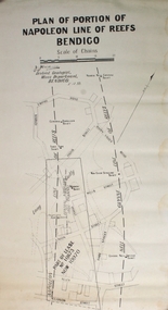
Plan - Part of Napoleon and Nell Gwynne Reefs
... Caldwell, Officer in charge of the Bendigo Geological branch of the Victorian Mines Department, received his early training in the Castlemaine and Bendigo Schools of Mines and later at the Melbourne Technical College Bendigo Margaret Roberts gold Map Mine Long Gully J.J. ...Mr. J. J. Caldwell, Officer in charge of the Bendigo Geological branch of the Victorian Mines Department, received his early training in the Castlemaine and Bendigo Schools of Mines and later at the Melbourne Technical CollegeBlack printing on off white colored paper- PLAN OF PORTION OF NAPOLEON LINE OF REEFS BENDIGO, Scale of Chains, a signature, District Geologist Mines Department BENDIGO. 5/12/39 Two vertical broken lines are labeled NAPOLEON LINE OF REEFS, NELL GYWNNE LINE OF REEFS and CENTRAL NAPOLEON LODE CHANNEL and mine shafts CENTRAL NAPOLEON, MOONTA, PTOPOSED NEW SHAFT, NORTH NEW GWYNNE, THREE TOMS, NEW CHUM SYNCLINE and CENTRAL NELL GWYNNE are drawn over a street map of the Long Gully area. The streets shown are; Empire Rd, Harvey St, Inglis St, Wells St, Union St, Alley St (now Marong Rd) and Curnow St. Forms part of the Margaret Roberts Collection bendigo, margaret roberts, gold, map, mine, long gully, j.j. caldwell -
 Bendigo Historical Society Inc.
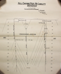
Plan - Nell Gwynne Reef
... He received his early training in the Castlemaine and Bendigo Schools of Mines and later at the Melbourne Technical College. He entered the Mines Department in 1900 as a junior chainman. Bendigo Margaret Roberts gold Map ...Mr. J. J. Caldwell was appointed Officer in charge of the Bendigo Geological branch of the Victorian Mine s Department in 1923. He received his early training in the Castlemaine and Bendigo Schools of Mines and later at the Melbourne Technical College. He entered the Mines Department in 1900 as a junior chainman. Draftsman's drawing in black ink on off-white paper. Printed at the top NELL GWYNNE REEF . NO LIABILTY BENDIGO Scale of feet (100 feet to an inch) Singed J. Caidwell District Field Geologist, Mines Department BENDIGO 12. 10. 1940 Underneath there is a drawing labeled TRANVERSE SECTION showing East, Natural surface, Nell Gwynne Anticline, Railway Goldfields shaft, New Chum Syncline, New Chum Railway Shaft, New Chum Anticline, West Forms part of the Margaret Roberts Collection bendigo, margaret roberts, gold, map, mine, j. j. caldwell -
 Bendigo Historical Society Inc.
Booklet - From Cotswold to Castlemaine
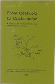
... map of Victorian Goldfields area on title page. B&W photos of George C R Collins and Jemima on page 13. B&W photo of family of George and Jemima on page 14. Printed by Advertiser (Jamieson) Printery. Booklet From Cotswold to Castlemaine ...A history of the Family of Charles and Hannah Collins, Pioneers. 24-page booklet. Compiled in 1973 by Iris E. Hocking (Great Granddaughter) and her father, George William Collins (Grandson). Sketch map of Victorian Goldfields area on title page. B&W photos of George C R Collins and Jemima on page 13. B&W photo of family of George and Jemima on page 14. Printed by Advertiser (Jamieson) Printery.Signature of Iris E. Hocking in ink at bottom of page 1.charles and hannah collins, family history, george c r collins, hannah charlotte whitaker-clarke, jemima martin, charles collins, hannah collins -
Bendigo Historical Society Inc.
Map - SECTIONS ACROSS BENDIGO GOLDFIELD
... Map in three sections showing sections across Bendigo Gold Field, showing anticlines, synclines, faults, stratigraphical zones and mines along the reef lines. Key shows rock types Castlemaine...History House 11 Mackenzie Street Bendigo goldfields BENDIGO Gold mining reef line maps Geological Survey of Victoria Map in three sections showing sections across Bendigo Gold Field, showing anticlines, synclines, faults, stratigraphical zones and mines along the reef lines. Key shows rock types Castlemaine ...Map in three sections showing sections across Bendigo Gold Field, showing anticlines, synclines, faults, stratigraphical zones and mines along the reef lines. Key shows rock types Castlemaine, Bendigo B1, B2, B3 and B4, and Lancefieldian. First part of map shows sections A-A, B-B and C-C. Reef lines drawn with mines listed: Fault line shown are the Carshalton, Stafford, New Chum, Virginia and Clarence. A datum line shows 600 ft above sea level. On bottom of plan: ' Prepared in the Geological Survey Office, Bendigo, under the direction of H. Herman, late Director of Geological Survey, from surveys by H.S. Whitelaw, Field Geologist, assisted by E.S. Usher, A.J.J. Moore and R.A. Keble.' Second section of map shows sections D-D, and E-E. Fault lines listed are the Tambour Major fault, Carshalton fault, Stafford fault, Nell Gwynne fault, New Chum fault, Deborah fault. Third section shows sections F-F and G-G. Fault lines listed are the Bird Reef fault, Kangaroo Gully fault, Langdon fault, Carshalton fault, Nell Gwynne fault, Spring Gully fault, Hustlers fault, Gravel Hill fault, Ordes fault, Thanet fault. This map forms part of the Geological Survey of Victoria, Structure of Bendigo Goldfield report, No. 47, 1923. H.Herman, late Director of Geological Survey.Geological Survey of Victoriabendigo, gold mining, reef line maps -
 Bendigo Historical Society Inc.
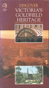
Book - Discover Victoria's Goldfield Heritage
... Includes Ballarat, Bendigo, Castlemaine and Stawell Written by Douglas Stone and Greg Dunnett First published 1993 by See Australia Guides Pty Ltd Printed and bound by Toppan, Hong Kong Includes route maps, city and town maps, town walks, scenic drives and bike rides....Includes Ballarat, Bendigo, Castlemaine and Stawell Written by Douglas Stone and Greg Dunnett First published 1993 by See Australia Guides Pty Ltd Printed and bound by Toppan, Hong Kong Includes route maps, city and town maps, town walks, scenic drives and bike rides. ...128-page illustrated soft cover book entitled 'Discover Victoria's Goldfield Heritage. Includes Ballarat, Bendigo, Castlemaine and Stawell Written by Douglas Stone and Greg Dunnett First published 1993 by See Australia Guides Pty Ltd Printed and bound by Toppan, Hong Kong Includes route maps, city and town maps, town walks, scenic drives and bike rides.Handwritten in pen PETER RYALL on title page.goldfields, bendigo, ballarat, castlemaine, see australia guides -
 Bendigo Historical Society Inc.
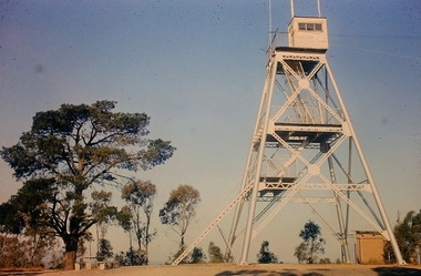
Slide - Peter Ellis Collection, Kaweka Wildflower Reserve, Castlemaine, Lightning Hill Lookout Bendigo, One Tree Hill Lookout Tower Bendigo, Kamarooka Forest Area, c1970-1972
... Castlemaine City to be a wildflower Reserve. A management committee was formed in 1966. The committee is still managing the park. Vicroads Edition 6: Map...Castlemaine City to be a wildflower Reserve. A management committee was formed in 1966. The committee is still managing the park. Vicroads Edition 6: Map ...Kaweka Reserve is a a small reserve of approximately 8ha. The land was donated to the Castlemaine City to be a wildflower Reserve. A management committee was formed in 1966. The committee is still managing the park. Vicroads Edition 6: Map 59E2, 628 H4 Location. Turner St, Castlemaine. From the Castlemaine Post Office, drive north (towards Bendigo) and turn right along Turner Street to the park entrance. What to do: walk along some of the tracks through the park follow the nature trail bird watch have a picnic at the picnic tables. RUSH Dam is a basic free camping area sits alongside Rush Dam in the Greater Bendigo National Park, featuring a single picnic table and wood fire barbecue.Peter Ellis Collection: Seventeen slides of Kaweka Wildflower Reserve, Castlemaine, Lightning Hill Lookout Bendigo, One Tree Hill Lookout Tower Bendigo. Also the Rush Dam free camping area at Kamarooka. Also a slide of an unknown group having a meal or day out; perhaps also a working bee. In addition there are two slides of a house - location not specified; and a working bee clearing along a pipeline at Big Hill. Peter was a chemistry lecturer at the Bendigo Institute of technology.history, bendigo, peter ellis collection, whipstick bendigo, bendigo state forests, kaweka wildflower reserve castlemaine, one tree hill lookout bendigo, lightning hill lookout bendigo, kamarooka, rush dam kamarooka, greater bendigo national park -
 Bendigo Historical Society Inc.
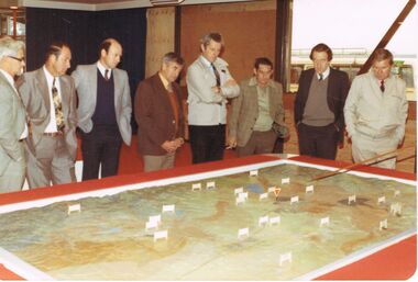
Photograph - CASTLEMAINE GAS COMPANY COLLECTION: PHOTO PEOPLE
... History House 11 Mackenzie Street Bendigo goldfields BUSINESS Retail gas and fuel Kodak 8 males looking at a map with several plastic markers on it Photograph CASTLEMAINE GAS COMPANY COLLECTION: PHOTO PEOPLE ...8 males looking at a map with several plastic markers on itKodakbusiness, retail, gas and fuel -
 Bendigo Historical Society Inc.
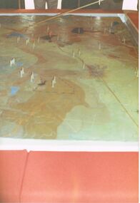
Photograph - CASTLEMAINE GAS COMPANY COLLECTION: PHOTO MAP
... CASTLEMAINE GAS COMPANY COLLECTION: PHOTO MAP...History House 11 Mackenzie Street Bendigo goldfields BUSINESS Retail gas and fuel Kodak Detailed map with several plastic markers on it. Photograph CASTLEMAINE GAS COMPANY COLLECTION: PHOTO MAP ...Detailed map with several plastic markers on it.Kodakbusiness, retail, gas and fuel -
 Bendigo Historical Society Inc.
Photograph - CASTLEMAINE GAS COMPANY COLLECTION: PHOTO MAP
... CASTLEMAINE GAS COMPANY COLLECTION: PHOTO MAP...History House 11 Mackenzie Street Bendigo goldfields BUSINESS Retail gas and fuel Kodak 7 males standing around looking at a detailed map of terrain, several plastic markers on the map. Photograph CASTLEMAINE GAS COMPANY COLLECTION: PHOTO MAP ...7 males standing around looking at a detailed map of terrain, several plastic markers on the map.Kodakbusiness, retail, gas and fuel -
 Bendigo Historical Society Inc.
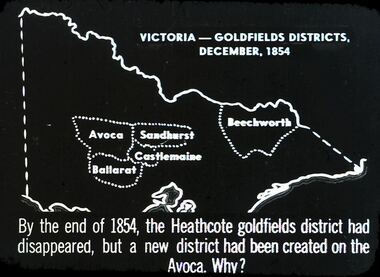
Slide - DIGGERS & MINING. THE GOLD LICENCE, c1854
... Slide depicts map of Victoria with the 5 gold rush regions marked on it. Beechworth, Sandhurst Avoca, Castlemaine and Ballarat. ...Slide depicts map of Victoria with the 5 gold rush regions marked on it. Beechworth, Sandhurst Avoca, Castlemaine and Ballarat. ...Diggers & Mining. The gold licence. The Government Camp. Slide depicts map of Victoria with the 5 gold rush regions marked on it. Beechworth, Sandhurst Avoca, Castlemaine and Ballarat. By the end of 1854, the Heathcote goldfields district had disappeared, but a district had been created on the Avoca. Why? Markings: 31 994.LIF. 4. Used as a teaching aid.hanimounteducation, tertiary, goldfields -
 Bendigo Historical Society Inc.
Photograph - COBB & CO,., MAP OF COACH RUN TO BENDIGO
... map of roads to all gold mines in Victoria., showing Cobb & Co., routes. Written on board: Cobb and Co., Cobb & Co's first and most historic run was from Melbourne to the goldfields of Castlemaine and Bendigo Creek, Jan 1854./// image shows -'Map of the roads to all gold mines in Victoria., showing the Cross roads from one mine to another with indications of various stations divided into squares of ten miles to easily calculate the distance of any new mines when discovered ///There is a list of towns with their distance from Melbourne and to & from distances for other destinations Cobb & Co., routes...map of roads to all gold mines in Victoria., showing Cobb & Co., routes. Written on board: Cobb and Co., Cobb & Co's first and most historic run was from Melbourne to the goldfields of Castlemaine and Bendigo Creek, Jan 1854./// image shows -'Map of the roads to all gold mines in Victoria., showing the Cross roads from one mine to another with indications of various stations divided into squares of ten miles to easily calculate the distance of any new mines when discovered ///There is a list of towns with their distance from Melbourne and to & from distances for other destinations Cobb & Co., routes Photograph COBB & CO,., MAP OF COACH RUN TO BENDIGO ...black and white image ( copy ) on board : image shows map of roads to all gold mines in Victoria., showing Cobb & Co., routes. Written on board: Cobb and Co., Cobb & Co's first and most historic run was from Melbourne to the goldfields of Castlemaine and Bendigo Creek, Jan 1854./// image shows -'Map of the roads to all gold mines in Victoria., showing the Cross roads from one mine to another with indications of various stations divided into squares of ten miles to easily calculate the distance of any new mines when discovered ///There is a list of towns with their distance from Melbourne and to & from distances for other destinations Cobb & Co., routesbusiness, transport, cobb & co., cobb & co., bendigo, transport -
Bendigo Historical Society Inc.
Map - HARCOURT : COUNTY OF BENDIGO, 23-3-10
... Map. County of Bendigo, County of Talbot, Sutton Grange, Ravenswood, Walmer, Faraday, Castlemaine, Axe Creek, Barkers Creek, Melbourne to Echuca Railway, Victorian Water Supply in Connection with Barkers Creek Reservoir. ...Map. County of Bendigo, County of Talbot, Sutton Grange, Ravenswood, Walmer, Faraday, Castlemaine, Axe Creek, Barkers Creek, Melbourne to Echuca Railway, Victorian Water Supply in Connection with Barkers Creek Reservoir. ...Map. County of Bendigo, County of Talbot, Sutton Grange, Ravenswood, Walmer, Faraday, Castlemaine, Axe Creek, Barkers Creek, Melbourne to Echuca Railway, Victorian Water Supply in Connection with Barkers Creek Reservoir. Victorian Water Supply Reserve, Mt. Alexander State Forest. Three areas reserved for Sericulture (Silkworms). Photo-Lithographed at the Dept. of Lands and Survey, Melbourne by T.F. McGauran 23-3-10. Price 1/-. (number 101 in map cupboard 1)T.F. McGauranmap, bendigo, harcourt -
Bendigo Historical Society Inc.
Map - HARCOURT : COUNTY OF BENDIGO, December 1951
... Map. Harcourt, County of Bendigo, County of Talbot, Ravenswood. Sutton Grange, Walmer, Castlemaine, Faraday, Calder Highway, Northern Railway, Town of Harcourt, Barkers Creek, Victorian Water Supply Res., in connection with Barkers Creek Reservoir. ...Map. Harcourt, County of Bendigo, County of Talbot, Ravenswood. Sutton Grange, Walmer, Castlemaine, Faraday, Calder Highway, Northern Railway, Town of Harcourt, Barkers Creek, Victorian Water Supply Res., in connection with Barkers Creek Reservoir. ...Map. Harcourt, County of Bendigo, County of Talbot, Ravenswood. Sutton Grange, Walmer, Castlemaine, Faraday, Calder Highway, Northern Railway, Town of Harcourt, Barkers Creek, Victorian Water Supply Res., in connection with Barkers Creek Reservoir. By authority J.J. Gourley, Government Printer, Melbourne .Drawn and reproduced at the Department of Lands and Survey, Melbourne. December 1951. Price 2/- per sheet. (number 96 in map cupboard 1)J.J. Gourley, Government Printer, Melbourne.map, bendigo, harcourt -
Bendigo Historical Society Inc.
Map - HARCOURT, December 1951
... Castlemaine, Sutton Grange. Mt.Alexander Trig. Station, Barkers Creek, Faraday, Calder Highway, Northern Railway. By Authority J.J.Gourley, Government Printer, Melbourne,Drawn and Reproduced at the Dept. of Lands and Survey, Melbourne, Victoria. December 1951. Price 5/-per sheet. (number 35 in map...History House 11 Mackenzie Street Bendigo goldfields MAP Bendigo harcourt J.J.Gourley, Government Printer, Melbourne. Harcourt, County of Bendigo, Walmer, Castlemaine, Sutton Grange. ...Harcourt, County of Bendigo, Walmer, Castlemaine, Sutton Grange. Mt.Alexander Trig. Station, Barkers Creek, Faraday, Calder Highway, Northern Railway. By Authority J.J.Gourley, Government Printer, Melbourne,Drawn and Reproduced at the Dept. of Lands and Survey, Melbourne, Victoria. December 1951. Price 5/-per sheet. (number 35 in map cupboard 1)J.J.Gourley, Government Printer, Melbourne.map, bendigo, harcourt -
 Bendigo Historical Society Inc.
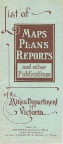
Document - LIST OF MAPS, PLANS, REPORTS PUBLISHED BY MINES DEPARTMENT VICTORIA 1938
... Booklet contains list of publications of geological reports, maps etc for Ararat, Ballarat, Beechworth, Bendigo, Castlemaine, Gippsland, Maryborough....Booklet contains list of publications of geological reports, maps etc for Ararat, Ballarat, Beechworth, Bendigo, Castlemaine, Gippsland, Maryborough. ...Blue booklet, on front ' List of Maps, Plans, Reports and other publications of the Mines Department of Victoria. Issued by Geo Brown Secretary for Mines under the authority of The Hon. E.J. Hogan, MLA, Minister of Mines. Booklet contains list of publications of geological reports, maps etc for Ararat, Ballarat, Beechworth, Bendigo, Castlemaine, Gippsland, Maryborough.Geo Brown, Secretary for Mines under the authority of The Hon.E.J. Hogan, M.L.A. Minister of Mines.organisation, government, geological maps list -
 Bendigo Historical Society Inc.
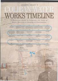
Document - JOSEPH BRADY COLLECTION: COLIBAN SYSTEM OF WATER WORKS PAMPHLET
... Historical Guide to 125 Years of Water Delivery to Bendigo & Castlemaine... Map...Castlemaine by Coliban Water. Mentioned in the brochure is Gold & Water, The Original Coliban System of Water Works, The Coliban System Today, The Coliban Engineer - Joseph Martin Brady (1828 - 1908), Coliban System of Water Works Key Facts & Figures, The Aqua Project, Historical Guide, Coliban System of Water Works Map, photo of Joseph Brady, Photo of gold diggers and channel works....History House 11 Mackenzie Street Bendigo goldfields CIVIL ENGINEERING Water supply coliban Joseph Brady's Coliban System of Water Works Coliban Water The Original Coliban System of Water Works The Coliban System Today Joseph Martin Brady 1828 - 1908 Gavan Prendergast Coliban System of Water Works Key Facts & Figures The Aqua Project Historical Guide to 125 Years of Water Delivery to Bendigo & Castlemaine Map of System Coliban Water Three copies of Joseph Brady's Coliban System of Water Works - A Historical Guide to Celebrate 125 Years of Water Delivery to Bendigo & Castlemaine by Coliban Water. ...Three copies of Joseph Brady's Coliban System of Water Works - A Historical Guide to Celebrate 125 Years of Water Delivery to Bendigo & Castlemaine by Coliban Water. Mentioned in the brochure is Gold & Water, The Original Coliban System of Water Works, The Coliban System Today, The Coliban Engineer - Joseph Martin Brady (1828 - 1908), Coliban System of Water Works Key Facts & Figures, The Aqua Project, Historical Guide, Coliban System of Water Works Map, photo of Joseph Brady, Photo of gold diggers and channel works.Coliban Watercivil engineering, water supply, coliban, joseph brady's coliban system of water works, coliban water, the original coliban system of water works, the coliban system today, joseph martin brady 1828 - 1908, gavan prendergast, coliban system of water works key facts & figures, the aqua project, historical guide to 125 years of water delivery to bendigo & castlemaine, map of system -
 Bendigo Historical Society Inc.
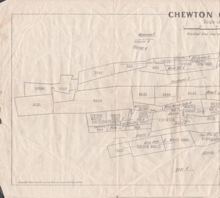
Map - MINING REPORTS - PLAN OF CHEWTON GOLDFIELD 1937
... History House 11 Mackenzie Street Bendigo goldfields MAP Mining Reports Plan of Chewton Goldfield Edward Dyason & Co The Stock Exchange of Melbourne Central Wattle Gully Wattle Gully United Wattle Gully Extended South Wattle Gully Golden Wattle Chewton White Horse Wattle Gully North Wattle Gully North Chewton Upper Barkly Post Office Hill Misima United Argus Hill Chapmans Chewton Prospecting Co Fiji Gold & Gold Mines of Fiji Nimrod Plan of the Chewton Goldfield with Scale Measurement in chains. Plan shows the township of Chewton with the reefs and leases, the railway line and the Main Castlemaine ...Plan of the Chewton Goldfield with Scale Measurement in chains. Plan shows the township of Chewton with the reefs and leases, the railway line and the Main Castlemaine - Melbourne Road. Also, the Eureka Vineyard. Issued by The Stock Exchange of Melbourne, April 1937. Leases named are: Central Wattle Gully, Wattle Gully United, Wattle Gully Extended, South Wattle Gully, Golden Wattle, Chewton, White Horse, Wattle Gully, North Wattle Gully, North Chewton, Upper Barkly, Post Office Hill, Misima United, Argus Hill, Chapmans, Chewton Prospecting Co, Fiji Gold & Gold Mines of Fiji and Nimrod. Stamp in the top right corner: Edward Dyason & Co. - Queen St. Melbourne. Sharebrokers.map, mining reports, plan of chewton goldfield, edward dyason & co, the stock exchange of melbourne, central wattle gully, wattle gully united, wattle gully extended, south wattle gully, golden wattle, chewton, white horse, wattle gully, north wattle gully, north chewton, upper barkly, post office hill, misima united, argus hill, chapmans, chewton prospecting co, fiji gold & gold mines of fiji, nimrod -
 Bendigo Historical Society Inc.
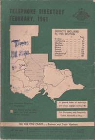
Book - TELEPHONE DIRECTORY FEBRUARY 1961, February 1961
... Districts covered are Bendigo, Castlemaine, Charlton, Deniliquin, Echuca, Kerang, Kyneton, Maryborough, Swan Hill. Cover has a green background with an outline of the map of Victoria in white. ...Districts covered are Bendigo, Castlemaine, Charlton, Deniliquin, Echuca, Kerang, Kyneton, Maryborough, Swan Hill. Cover has a green background with an outline of the map of Victoria in white. ...Soft covered Telephone Directory February 1961. Districts covered are Bendigo, Castlemaine, Charlton, Deniliquin, Echuca, Kerang, Kyneton, Maryborough, Swan Hill. Cover has a green background with an outline of the map of Victoria in white. The Victorian Telephone directory boundaries are indicated and the district covered is shaded with black dots. Some handwritten jottings are written in ink on the cover. The directory contains both white and pink pages.book, bendigo, bendigo history & its people -
 Bendigo Historical Society Inc.
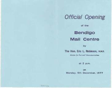
Document - DOCUMENT - OFFICIAL OPENING OF THE BENDIGO MAIL CENTRE, 05/12/1977
... On the inside, is another map from Kyneton - Echuca, Robinvale, Wentworth, Ouyen and to Bendigo via Charlton. Also Castlemaine. ...On the inside, is another map from Kyneton - Echuca, Robinvale, Wentworth, Ouyen and to Bendigo via Charlton. Also Castlemaine. ...The Victorian Mail Network brochures, two with Official Opening of the Bendigo Mail Centre Programs. The Opening took place on Monday, 5th December, 1977.In the program are some Postal Historical notes and the program for the day. The brochure Victorian Mail Network has a map of the postal districts of Victoria with Country and Metropolitan Mail Centres and some notes on the front. On the inside, is another map from Kyneton - Echuca, Robinvale, Wentworth, Ouyen and to Bendigo via Charlton. Also Castlemaine. It has a list of the Benefits of the Scheme. On the back is a table, Standard of Service - Final posting times.bendigo, institutions, bendigo post office, document, official opening of the bendigo mail centre, the hon. eric l. robinson, m.h.r., joseph cusworth, sir john nimmo, john w henderson, r j page, cr r f turner, c g primmer, j w bourchier, b coughlan -
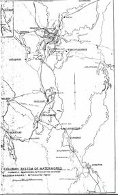 Bendigo Historical Society Inc.
Map - STATE RIVERS AND WATER SUPPLY COMMISSION : COLIBAN SYSTEM OF WATERWORKS MAP
... The map includes the areas from Goornong to south of Kyneton and across to Maldon: Goornong, Marong, Bendigo, Strathfieldsaye, Lockwood, Maldon, Harcourt, Castlemaine, Newstead, Elphinstone, Taradale, Malmsbury, Kyneton....The map includes the areas from Goornong to south of Kyneton and across to Maldon: Goornong, Marong, Bendigo, Strathfieldsaye, Lockwood, Maldon, Harcourt, Castlemaine, Newstead, Elphinstone, Taradale, Malmsbury, Kyneton. ...State Rivers and Water Supply Commission. Photocopied foolscap-size map. Title: Coliban System of Waterworks. Channels, reservoirs, reticulation systems. Maldon - S.R. & W.S.C. reticulated towns. The map includes the areas from Goornong to south of Kyneton and across to Maldon: Goornong, Marong, Bendigo, Strathfieldsaye, Lockwood, Maldon, Harcourt, Castlemaine, Newstead, Elphinstone, Taradale, Malmsbury, Kyneton.state infrastructure, water supply, coliban system, state rivers and water supply commission. coliban system.