
Showing 3 items matching "map of kiewa 1950"
-
 Kiewa Valley Historical Society
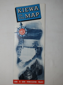
Map - Kiewa on the Map, Guide to Kiewa Hydro-Electric Project
... Map of Kiewa 1950...1950. They controlled the roads from Mt Beauty to the Bogong High Plains and all other roads within the Kiewa works area. The roads are not open to general tourist traffic. Conducted tours of the Kiewa area are operated by Eastern Road Lines Pty. Ltd., Albury The SECV constructed the KHES and controlled all roads within the Kiewa works area. Map ...Published by the SECV in 1950. They controlled the roads from Mt Beauty to the Bogong High Plains and all other roads within the Kiewa works area. The roads are not open to general tourist traffic. Conducted tours of the Kiewa area are operated by Eastern Road Lines Pty. Ltd., AlburyThe SECV constructed the KHES and controlled all roads within the Kiewa works area.Large colored map folded in half and then in 3. Front third is mostly blue and white with titles.. When opened the cover has black and white photos beside it with print and 'Please Note'. Also in the other half, a 'Road Map to Kiewa' showing the south eastern side of Australia, mostly yellow (the land) and blue (the sea). Inside the map is a close up map of "Ground Plan of Kiewa Hydro Electric Project' with a 'Key Map Showing Distances'.map of kiewa 1950, khes map -
 Kiewa Valley Historical Society
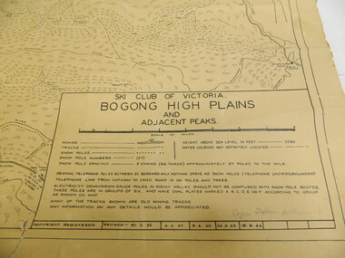
Map - Topographical, Ski Club of Victoria Bogong High Plains and Adjacent Peaks, Early 1930's
... map has been in the Ryder family for approx. 70 years. Probably used when bush walking and skiing in the early days on the Bogong High Plains. The Ryder family are farmers in the Kiewa Valley and were involved in taking their cattle up to the Bogong High Plains where they had a lease. The State Electricity Commission of Victoria constructed the Kiewa Hydro Electric Scheme opening up the area during the 1940's and 1950...map has been in the Ryder family for approx. 70 years. Probably used when bush walking and skiing in the early days on the Bogong High Plains. The Ryder family are farmers in the Kiewa Valley and were involved in taking their cattle up to the Bogong High Plains where they had a lease. The State Electricity Commission of Victoria constructed the Kiewa Hydro Electric Scheme opening up the area during the 1940's and 1950 ...This map has been in the Ryder family for approx. 70 years. Probably used when bush walking and skiing in the early days on the Bogong High Plains. The Ryder family are farmers in the Kiewa Valley and were involved in taking their cattle up to the Bogong High Plains where they had a lease. The State Electricity Commission of Victoria constructed the Kiewa Hydro Electric Scheme opening up the area during the 1940's and 1950's. This type of map is an early one, used by people in the Kiewa Valley and possibly by surveyors prior to construction.The map is an early topographic map used by farmers living in the Kiewa Valley. It is historically significant as these people were involved in taking cattle up to the High Plains during summer and may have been used for bush walking and skiing.This is a sepia coloured paper map which was originally printed copyright registered. It was revised in 20/6.33/4.4.37/8.4.40/24.8.43/19/6/54. It shows roads / tracks / snow poles / snow pole numbers (27) / Snow pole spacing (3 chains. 66 yards) approximately 27 poles to the mile / height above sea level in feet - 5280. Water courses not definitely located etc.Rocky Valley Dam (Kiewa Hydro Electric Scheme) has been drawn on the map by hand with a biro. There is a wooden rod at the top of the map.topographic map; kiewa valley; ryder family; high plains of victoria -
 Kiewa Valley Historical Society
Mt Beauty Primary School - 75th Anniversary memorabilia
... Kiewa Hydro Electric Scheme which was constructed by the SECV from the late 1940s to 1961. The school was built in 1948 and had 170 pupils from Prep to Year 7 in 1950. It grew quickly with new families moving in as well as supporting children from the Kiewa Valley. Parents were confident that their children would be well educated. Mt Beauty Primary School Mt Beauty Higher Elementary School Papers - typed '75th Birthday Celebrations'; Walking Map ...The Mt Beauty Primary School No. 4644/ Higher Elementary / High School. 75th anniversary was celebrated on 4th November 2023. The school was built for the children of the workers on the Kiewa Hydro Electric Scheme which was constructed by the SECV from the late 1940s to 1961.The school was built in 1948 and had 170 pupils from Prep to Year 7 in 1950. It grew quickly with new families moving in as well as supporting children from the Kiewa Valley. Parents were confident that their children would be well educated.Papers - typed '75th Birthday Celebrations'; Walking Map of Historic Tour; Photocopy of blackboard; Mt Beauty School timetable; x3 photocopies of classroom students photos eg. Mount Beauty School 1971. x2 student work books; Photos: school being built, Grade 4 1953, and x6 copies of photos of people that attended the reunion. mt beauty primary school, mt beauty higher elementary school
