Showing 6 items matching "map ww2. north borneo"
-
 Warrnambool RSL Sub Branch
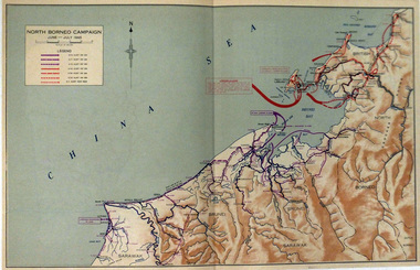
Map, NORTH BORNEO CAMPAIGN. June-July 1945
... Map WW2. North Borneo...Warrnambool RSL Sub Branch Cnr Merri & Liebig Streets Warrnambool great-ocean-road Map WW2. North Borneo Different coloured arrows show troop movements in Brunei and Labuan Island Paper. ...Paper. Colour. Different coloured arrows show troop movements in Brunei and Labuan Islandmap ww2. north borneo -
 Bendigo Military Museum
Map - MAPS, ISLANDS WW2, Post 1945
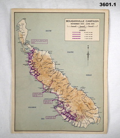
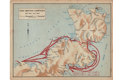
... Maps bouganville tarakan islands .1) Coloured paper map of Bougainville Campaign, New Britain Campaign & Aitape - Wewak Campaign. .2) Coloured paper map of Tarakan Campaign, Balikpapin Campaign & North Borneo Campaign. Map MAPS, ISLANDS WW2 ...Items were owned by William John GARLAND, 5th Army Troop. Illustrated information of the named campaigns of 1944-45..1) Coloured paper map of Bougainville Campaign, New Britain Campaign & Aitape - Wewak Campaign. .2) Coloured paper map of Tarakan Campaign, Balikpapin Campaign & North Borneo Campaign.maps, bouganville, tarakan, islands -
 Lara RSL Sub Branch
Map, World War 2 Borneo Area, 1945
... Lara RSL Sub Branch McClelland Ave Lara Military maps of Australian Campaigns in the Borneo area World War 2 Borneo New Britain Bougainville Wewak Maps WW2 Map 1 Centre section opened - North Borneo Campaign June - July 1945. ...Military maps of Australian Campaigns in the Borneo area World War 2paper coloured maps from unknown bookMap 1 Centre section opened - North Borneo Campaign June - July 1945. Closed Side 1 - Tarakan Campaign 1 May - 21 June 1945. Side 2 Balikpapan Campaign July 1945 Map 2 Centre section opened - Aitape-Wewak Campaign Nov 1944 - Aug 1945. Closed Side 1 Bougainville Campaign Nov 1944 - June 1945 New Britain Campaign Oct 1944 - July 1945borneo new britain bougainville wewak maps ww2 -
 Shepparton RSL Sub Branch
Escape Map Cloth, July 1944
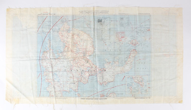
... Shepparton RSL Sub Branch 88 Wyndham Street Shepparton the-murray Silk escape map issued to Allied Airmen during World War 11 for the Pacific campaigns A silk escape map including detail of tides and winds was relevant to air force personnel in Pacific regions during WW2. world war ii second world war silk escape map pacific conflict AAF Cloth Cart- Philippine Series Prepared under the direction of the Commanding General, Army Air Forces, by the aeronautical Chart Service, Washington DC July 1944 Coloured Cloth Escape Map of Side A : No. C44 North Borneo ...Silk escape map issued to Allied Airmen during World War 11 for the Pacific campaignsA silk escape map including detail of tides and winds was relevant to air force personnel in Pacific regions during WW2. Coloured Cloth Escape Map of Side A : No. C44 North Borneo Side B: No C43 Mindanao Island SCALE: 1:1,000,000; Wind and Current markings; AAF Cloth Cart- Philippine Series Prepared under the direction of the Commanding General, Army Air Forces, by the aeronautical Chart Service, Washington DC July 1944world war ii, second world war, silk escape map, pacific conflict -
 Running Rabbits Military Museum operated by the Upwey Belgrave RSL Sub Branch
Pilot's Map
... Equipment WW2 RAAF Map of North Borneo and surrounds and East Java Pilot's Map ...Part of Survival Kit.Map of North Borneo and surrounds and East Javaequipment, ww2, raaf -
 Bendigo Military Museum
Map - SILK MAPS, LAND HQ CARTOGRAPHIC COY, 1939-1945
... WW2 Silk maps Pacific War Z Special Unit Gilbert Kerr MacKenzie 1. & 2. White silk maps, printing in black ink. Topographer information, roads and rivers shown. It aso shows place names and border lines, i.e. British North Borneo ...The soldier who had these was; "Gilbert Kerr MacKenzie", N247489 (born Sydney, enlisted Marrackville) on 6 Nov 1941, Age 18 years, 9 mths. Transferred to 2nd AIF 12 Nov 1942 as number NX132907. Promoted in the field to Lieut, 4 Feb 1945. Posted to “Z” Special Unit. Discharged 14 Aug 1946. Last Rank Lieut in WW2. Later Colonel when retired. Last Unit - “Z” Special Unit.1. & 2. White silk maps, printing in black ink. Topographer information, roads and rivers shown. It aso shows place names and border lines, i.e. British North Borneo, China Sea, Dutch Borneo. It covers 109.5 to 116 degrees East and 0.5 to 116 degrees North Lat. On the maps are printed Divisional areas - 1st to 5th Division. The maps are not hemmed. Words are in English.ww2, silk maps, pacific war, z special unit, gilbert kerr mackenzie