Showing 2910 items matching "maps of victoria"
-
 Kiewa Valley Historical Society
Maps of Victoria
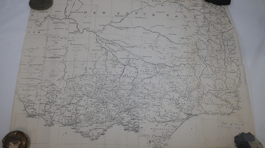
... Maps of Victoria...maps of victoria...Hiscock & Co's, New Victoria Countries Atlas 1874'. 3. Map of the Murray and Gipps Land Distr' with handwritten: "Baillieu's County Atlas of Victoria 1866'....Maps of Victoria ...Three maps: copies from the 19th century. 1. Handwritten 'Dept of Lands & Survey 1876'. 2. Map of the Ovens & Murray District, Victoria with handwritten 'F.H. Hiscock & Co's, New Victoria Countries Atlas 1874'. 3. Map of the Murray and Gipps Land Distr' with handwritten: "Baillieu's County Atlas of Victoria 1866'.maps of victoria, 19th century, oven and murray district of victoria -
 Kew Historical Society Inc
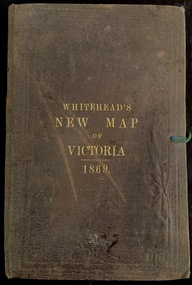
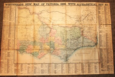
Map, Whitehead's Map of Victoria, With Alphabetical Key, 1869, 1869
... Whitehead's Map of Victoria, With Alphabetical Key, 1869...e whitehead's new map of victoria 1869...The following year, 1870, Whitehead's promoted the edition in the Portland Guardian and Normanby General Advertiser (3 January 1870), advising that: "WHITEHEAD'S NEW MAP OF VICTORIA, 1869 ... is corrected to the latest date, and around is arranged an Alphabetical Key, with Post Towns and Money Order Olffices marked. ...Map of Victoria with gold mining areas, notes on topography, transport routes. ...Cover "WHITEHEAD'S NEW MAP OF VICTORIA 1869"...In addition to its historical significance, this is a rare map, of which the only known copies in Australian public collections are those held at the National Library of Australia, the State Library of Victoria, State Library of New South Wales and the University of Queensland Library. maps - victoria - 1860s e whitehead's new map of victoria 1869 whitehead's map of victoria with alphabetical key 1869 cartography gold rush Cover "WHITEHEAD'S NEW MAP OF VICTORIA 1869" Map of Victoria with gold mining areas, notes on topography, transport routes. ...When E. Whitehead's New Map of Victoria was released in 1869, an advertisement in the Bendigo Advertiser (16 July 1869) noted that: "This beautifully engraved Map has been revised and brought down to the present time; and, with the Alphabetical Key, is the most complete and the cheapest Map ever published; Price, 6d plain; 1s colored; 2s 6d in case; on linen, post free, 2d extra. E.. WHITEHEAD and CO, Publishers, 67 Collins-street east." The following year, 1870, Whitehead's promoted the edition in the Portland Guardian and Normanby General Advertiser (3 January 1870), advising that: "WHITEHEAD'S NEW MAP OF VICTORIA, 1869 ... is corrected to the latest date, and around is arranged an Alphabetical Key, with Post Towns and Money Order Olffices marked. The Map being divided into squares and numbered, by reference to the Key any place can be found immediately. Price Is beautifully colored, or mounted on linen in case, 2s 6d. Post free, 2d extra, in Victoria. B. Whitehead and C0., Puolishers, 67 Collins-street East, Melbourne". In the same edition of the Portland Advertiser, they also promoted their business generally, saying: "E WHITEHEAD and Co., Stationers, Engravers, Lithographers, 67 Collins street East, execute every description of Lithographic PRINTING, BILL-HEADS. NOTE Headings. Business Dies Engraved and Embossed on Envelopes &c. ARMS, MONOGRAMS, AND CRESTS Engraved and Embossed in Colour, superior to any other house in the Colony. Specimens, post free, 2d. Lithographers, &c, to H.R.H. the Duke of Edinburgh, and Die-inkers and Embossers to His Excellency Sir J. H. T. Manners-Sutton, K C.B. Orders executed for the Trade". Whitehead’s New Map of Victoria 1869 is is an important record of region created towards the end of the Victorian Gold Rush (1851-1869). In addition to its historical significance, this is a rare map, of which the only known copies in Australian public collections are those held at the National Library of Australia, the State Library of Victoria, State Library of New South Wales and the University of Queensland Library.Map of Victoria with gold mining areas, notes on topography, transport routes. Relief shown by hachures. List of towns with distance from Melbourne in map margin. [Melbourne] : Printed & Published by ... E Whitehead & Co ... 67 Collins Street East, 1869 1 map : col., mounted on linen ; 38.4 x 55.4 cm, folded to 18 x 12 cm.Cover "WHITEHEAD'S NEW MAP OF VICTORIA 1869"maps - victoria - 1860s, e whitehead's new map of victoria 1869, whitehead's map of victoria with alphabetical key 1869, cartography, gold rush -
 Sunshine and District Historical Society Incorporated
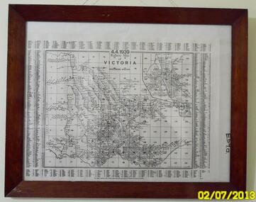
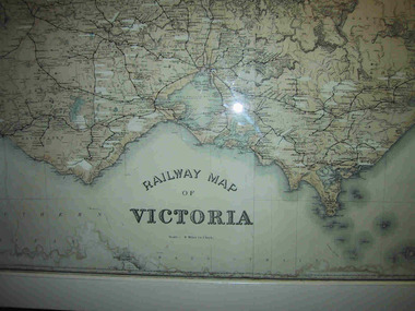
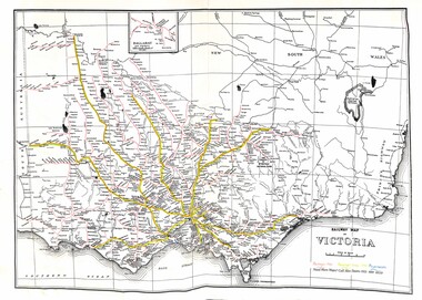
Map - Railway Map Of Victoria 1939
... Railway Map Of Victoria 1939...Map in frame showing the RAILWAY LINES of VICTORIA plus PASSENGER MILEAGES as of 4.4.1939. ...Railway Map of Victoria...Railway Railway Map of Victoria Map in frame showing the RAILWAY LINES of VICTORIA plus PASSENGER MILEAGES as of 4.4.1939. ...Historical record of the railway line system in the state of Victoria in 1939.Many of the railway lines no longer exist.Railway Map of Victoriarailway -
 Rutherglen Historical Society
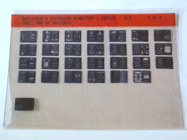
Microfiche, Bailliere's Victorian Directory 1871/2, 1871/72
... ...victoria...Map...SLV Incl. Map Of Victoria...Rutherglen Historical Society Murray Street Rutherglen high-country A directory in Victoria town names victoria Map SLV Incl. Map Of Victoria small sheet of film Bailliere's Victorian Directory 1871/2 Microfiche ...A directory in Victoriasmall sheet of film SLV Incl. Map Of Victoriatown, names, victoria, map -
 Bendigo Historical Society Inc.
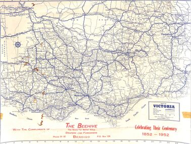
Map - Edith Perry Collection: Map of Victoria, produced by The Beehive celebrating their centenary 1852 - 1952 for patrons, 1952
... Edith Perry Collection: Map of Victoria, produced by The Beehive celebrating their centenary 1852 - 1952 for patrons...Map of Victoria...Edith Perry Collection: A3 Map of Victoria printed in blue and red ink. The map was produced for The Beehive department store (referenced as Drapers and Furnishers) in celebration of their Centenary 1852 - 1952. ...Map of Victoria Victorian towns and roads Map Edith Perry Collection: A3 Map of Victoria printed in blue and red ink. ...Map of VictoriaEdith Perry Collection: A3 Map of Victoria printed in blue and red ink. The map was produced for The Beehive department store (referenced as Drapers and Furnishers) in celebration of their Centenary 1852 - 1952. The map was provided to customers with "compliments of the Beehive". The rear of the map has a full index of Victorian towns and a Victorian Mileage table. The map was produced by R.M. Harrison Pty. Ltd., Printers and Map Publishers, 422 Collins Street, Melbouirnew, Victoria.victorian towns and roads, map -
 Wodonga & District Historical Society Inc
Map - Whiteheads New Map of Victoria, E. Whitehead & Co., engravers & lithographers, 1868
... Whiteheads New Map of Victoria ...Whiteheads New Map of Victoria ...His series of maps of Victoria became one of the most successful and most profitable series of regional maps of Australia ever produced....A detailed early map of Victoria with counties clearly marked and shaded and a detailed index. ...Whiteheads New Map of Victoria Map Whiteheads New Map of Victoria E. ...Edward Whitehead was a printer and publisher active in Melbourne during the latter half of the 19th century. Whitehead founded his printing business at 67 Collins Street East in 1864 and, though not focused on maps, began publishing his own series of maps of Victoria in 1867. He focussed on producing highly detailed folding maps of Victoria which included a very detailed index of place names. His series of maps of Victoria became one of the most successful and most profitable series of regional maps of Australia ever produced.This is a very early map of Victoria showing Belvoir (Wodonga)A detailed early map of Victoria with counties clearly marked and shaded and a detailed index. It also shows roads, post office towns, railways, telegraphs, gold mining areas and notes on topography. Relief shown by hachures and spot heights. Includes a list of towns with distances from Melbourne on 3 sides of map. It is produced on paper mounted on linen.victoria cartography, rare maps victoria, whiteheads maps -
 Parks Victoria - Mount Buffalo Chalet
Map, "Railway Map of Victoria"
... "Railway Map of Victoria"...Large framed map of Victoria, showing Victorias extensive rail network. ...Large railway map of Victoria, Melbourne & Ballarat framed in white painted wood. ...Areas of the map have been whited out. "Railway Map of Victoria" Map ...Large framed map of Victoria, showing Victorias extensive rail network. Printed by Victorian Railways and is one of a number of 'framed pictures, particularly photographs of scenery, which have always been a feature of the Chalet.' (Pg 83. Historica, 2011) This map has been a permanent fixture situated in the hallway alongside the ballroom leading to the ski hire area since the 1950's and most likely earlier. Listed in Draft Inventory of Significant Collection ItemsLarge railway map of Victoria, Melbourne & Ballarat framed in white painted wood. Scale eight miles to one inch. Areas of the map have been whited out.Yes -
 Yarrawonga and Mulwala Pioneer Museum
Map, Map of Victoria, 1868
... Map of Victoria...1868 Map of Victoria...Yarrawonga and Mulwala Pioneer Museum 151 Melbourne St, Mulwala Original property of Alice Rebecca Puckey [nee Ford] Born England 23/07/1867 Died rosbud Vic 16/03/1951 Grandmother of Merven Elizabeth Clarke 30 Sturt st Mulwala 1868 Map of Victoria Map of Victoria Map ...Original property of Alice Rebecca Puckey [nee Ford] Born England 23/07/1867 Died rosbud Vic 16/03/1951 Grandmother of Merven Elizabeth Clarke 30 Sturt st Mulwala1868 Map of Victoria -
 Ballarat Heritage Services
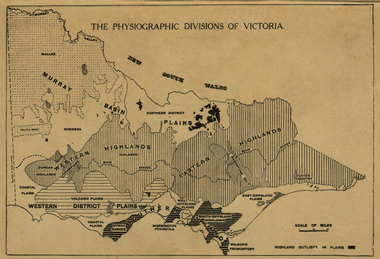
Map, Physiographic Divisions of Victoria, c1940, c1940
... victoria...map...Physiographic map of Victoria...Ballarat Heritage Services PO Box 2209 Bakery Hill Post Office goldfields victoria map physiography Physiographic map of Victoria Physiographic Divisions of Victoria, c1940 Map ...Physiographic map of Victoriavictoria, map, physiography -
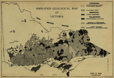 Ballarat Heritage Services
Map, Simplified Geological Map of Victoria, c1940, c1940
... Simplified Geological Map of Victoria, c1940...victoria...map...Physiographic map of Victoria....Ballarat Heritage Services PO Box 2209 Bakery Hill Post Office goldfields victoria map geology geological Physiographic map of Victoria. ...Physiographic map of Victoria.victoria, map, geology, geological -
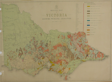 Federation University Historical Collection
Map, Department of Mines - Victoria, Geological Map of Victoria, 1936, 1936
... Geological Map of Victoria, 1936...victoria...geology...map...Printed colour geological map of Victoria....Geological Map of Victoria, 1936 Map Department of Mines - Victoria ...Printed colour geological map of Victoria.victoria, geology, map, geological map -
Stawell Historical Society Inc
Map, Whitehead's Map of Victoria, with Alphabetical Key, 1869
... Whitehead's Map of Victoria, with Alphabetical Key...Whitehead's Map of Victoria, with Alphabetical Key...Stawell Historical Society Inc 46 Longfield St Stawell grampians Stawell Whitehead's Map of Victoria, with Alphabetical Key Whitehead's Map of Victoria, with Alphabetical Key Map ...Whitehead's Map of Victoria, with Alphabetical Keystawell -
 Sunshine and District Historical Society Incorporated
Map - Railway Map of Victoria, Yarra Valley Railways Healesville
... Railway Map of Victoria...Railway Map of Victoria Railways in 1946, Passenger Lines in 1990 and Preservation Lines...Railway Railway Map of Victoria Railways in 1946, Passenger Lines in 1990 and Preservation Lines Map of Victoira showing Railways in 1946, Passenger Lines in 1990 and Preservation Lines Map Railway Map of Victoria Yarra Valley Railways Healesville ...Railway Map of Victoria Railways in 1946, Passenger Lines in 1990 and Preservation Linesrailway -
Glenelg Shire Council Cultural Collection
Souvenir - Spoon - Commemorative Victoria 150th, n.d
... Spoon commemorative Victoria 150th with map of Victoria....Glenelg Shire Council Cultural Collection History House Cliff Street Portland great-ocean-road Spoon commemorative Victoria 150th with map of Victoria. Souvenir Spoon - Commemorative Victoria 150th ...Spoon commemorative Victoria 150th with map of Victoria. -
Stawell Historical Society Inc
Map, Land Map of Victoria 1898, Supplement to "The Leader", 1898
... Land Map of Victoria 1898, Supplement to "The Leader"...Land Map of Victoria 1898, Supplement to "The Leader"...Stawell Historical Society Inc 46 Longfield St Stawell grampians Stawell Land Map of Victoria 1898, Supplement to "The Leader" Land Map of Victoria 1898, Supplement to "The Leader" Map ...Land Map of Victoria 1898, Supplement to "The Leader"stawell -
Stawell Historical Society Inc
Photograph - Mining Scene, Close up
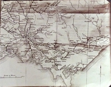
... Sepia Print Mining Scene, map of Victoria marking Stawell...Stawell Historical Society Inc 46 Longfield St Stawell grampians See Holtman Panarama photo 2 MIning Stawell Sepia Print Mining Scene, map of Victoria marking Stawell Close up Photograph Mining Scene ...See Holtman Panarama photo 2Sepia Print Mining Scene, map of Victoria marking Stawellmining, stawell -
 Nhill Aviation Heritage Centre
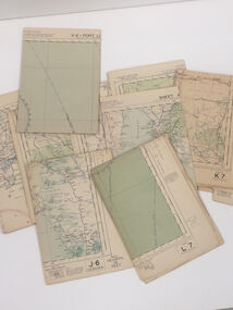
Map - Aeronautical Maps x 9, May 1943
... Aeronautical maps of Victoria, Printed on light card green text and markings...Nhill Aviation Heritage Centre 1 Aerodrome Road Nhill grampians Typical of the maps used during navigation training here at Nhill during WW2 map aeronaughtical map navigation Third Edition May 1943, Sheet K8, Australian Aeronautical Map, Equatorial scale 1:1000,000 Aeronautical maps of Victoria, Printed on light card green text and markings Map Aeronautical Maps x 9 ...Typical of the maps used during navigation training here at Nhill during WW2Aeronautical maps of Victoria, Printed on light card green text and markingsThird Edition May 1943, Sheet K8, Australian Aeronautical Map, Equatorial scale 1:1000,000map, aeronaughtical map, navigation -
 Phillip Island and District Historical Society Inc.
Photograph, Rail Lines of Victoria, Early to mid 20th century
... ...victoria...map...Map showing extensive railway network in Victoria in early C20th....Sepia photo of map of Victoria showing rivers and railway lines and stations....Phillip Island and District Historical Society Inc. phillip-island-and-the-bass-coast Map showing extensive railway network in Victoria in early C20th. sepia photograph rail transport victoria map Names of towns, rivers, bays etc Sepia photo of map of Victoria showing rivers and railway lines and stations. ...Map showing extensive railway network in Victoria in early C20th.Sepia photo of map of Victoria showing rivers and railway lines and stations.Names of towns, rivers, bays etcsepia photograph, rail transport, victoria, map -
 Stawell Historical Society Inc
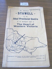
Book, Council of the Town of Stawell, The Advantages of Stawell as the Ideal Provincial Centre, 1966
... Tan card cover with black border inside of which is a map of Victoria...Prepared by the Council of the Town of Stawell Jointly with the Stawell Development Association September1966 Tan card cover with black border inside of which is a map of Victoria The Advantages of Stawell as the Ideal Provincial Centre Book Council of the Town of Stawell ...Tan card cover with black border inside of which is a map of VictoriaThe Advantages of Stawell as the Ideal Provincial Centre to be developed right in the heart of Western Victoria. Prepared by the Council of the Town of Stawell Jointly with the Stawell Development Association September1966stawell tourism -
 Stawell Historical Society Inc
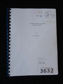
Book, R.B. Watchorn, A Pictorial History of Gold Mining at Stawell Victoria - Previously Cat No 3632, 06 April 1986
... White Paper cover with map of Victoria inside two oval rings....Watchorn R Watchorn (Signature) Stawell, Vic 6 April, 1986 White Paper cover with map of Victoria inside two oval rings. A Pictorial History of Gold Mining at Stawell Victoria - Previously Cat No 3632 Book R.B. ...Photos and extracts from the proposed new pictorial history of gold mining in Stawell. PLEASE NOTE: This book is not very accurate, lots of mistakes.White Paper cover with map of Victoria inside two oval rings.A Pictorial History of Gold Mining at Stawell, Victoria By R.B. Watchorn R Watchorn (Signature) Stawell, Vic 6 April, 1986stawell -
 Bendigo Historical Society Inc.
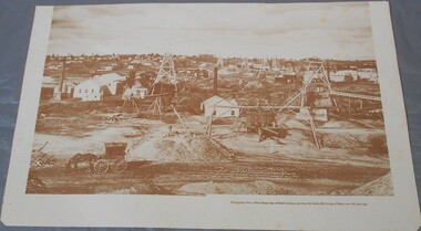
Photograph - Photograph of New Chum Line of Reef
... On the back a drawing of a poppet head with the words: Bendigo gold project. A small map of Victoria is also printed on the back. ...History House 11 Mackenzie Street Bendigo goldfields BHS Collection Bendigo Mines New Chum Line of Reef Mining On the back a drawing of a poppet head with the words: Bendigo gold project. A small map of Victoria is also printed on the back. Sepia coloured print of a photograph of the New Chum Line of Reef looking south from the Snobs Hill group of mines. ...BHS CollectionSepia coloured print of a photograph of the New Chum Line of Reef looking south from the Snobs Hill group of mines. The photo shows several poppet heads and chimneys, bridges and houses. New Chum Line of Reef. includes Victoria Hill possibly the richest spot on the field.On the back a drawing of a poppet head with the words: Bendigo gold project. A small map of Victoria is also printed on the back. bendigo mines, new chum line of reef, mining -
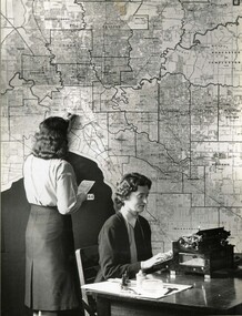 Victoria Police Museum
Photograph (Auxiliary police)
... Auxiliary Police woman looking at a traffic map of Victoria at D24 in Russell Street....Victoria Police Museum 313 Spencer Street Docklands melbourne Taken from an album of various police departments at Russell Street. police women d24 russell street women's police auxiliary force police woman policewomen policewoman Auxiliary Police woman looking at a traffic map of Victoria at D24 in Russell Street. Photograph (Auxiliary police) ...Taken from an album of various police departments at Russell Street. Auxiliary Police woman looking at a traffic map of Victoria at D24 in Russell Street.police women, d24, russell street, women's police auxiliary force, police woman, policewomen, policewoman -
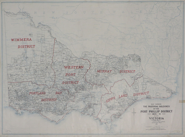 Federation University Historical Collection
Plan, Map Showing the Pastoral Holdings of the Port Phillip District 1835-1851 Now Victoria, 1932, 1932
... Map Showing the Pastoral Holdings of the Port Phillip District 1835-1851 Now Victoria, 1932...Map of Victoria showing the boundaries of the Port Phillip District (Victoria) pastoral boundaries. ...Information on Alfred Stephen Kenyon of the Historical Society of Victoria can be found at http://adb.anu.edu.au/biography/kenyon-alfred-stephen-6936/text12035 pastoral holdings squatters squatting victoria land crown lands a.s. kenyon alfred stephen kenyon Map of Victoria showing the boundaries of the Port Phillip District (Victoria) pastoral boundaries. ...Another name for Pastoral Holdings is squatting runs. Information on Alfred Stephen Kenyon of the Historical Society of Victoria can be found at http://adb.anu.edu.au/biography/kenyon-alfred-stephen-6936/text12035 Map of Victoria showing the boundaries of the Port Phillip District (Victoria) pastoral boundaries. pastoral holdings, squatters, squatting, victoria, land, crown lands, a.s. kenyon, alfred stephen kenyon -
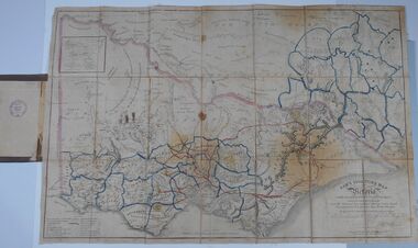 Bendigo Historical Society Inc.
Document - HARRIS COLLECTION: HAMS SQUATTING MAP OF VICTORIA, PORT PHILLIP DISTRICT, NSW
... HARRIS COLLECTION: HAMS SQUATTING MAP OF VICTORIA, PORT PHILLIP DISTRICT, NSW...MAP...Victoria...(State Library Victoria https://www.slv.vic.gov.au/squatting-map-victoria)...Map backed by cloth and bound. Rare, early map of Victoria and neighbouring Port Phillip District of New South Wales. ...(State Library Victoria https://www.slv.vic.gov.au/squatting-map-victoria) MAP Victoria squatting map Folding map enclosed in burgundy cover. ...Thomas Ham was a cartographer, engraver, lithographer and publisher in Victoria and Queensland. He compiled and printed several editions of his squatting map, beginning with A map of Australia Felix in 1847 and changing its title to Ham's squatting map of Victoria in 1851. The 1851 edition was accompanied by a key listing the names of all the squatters within squatting districts and counties. Later editions show the existing counties, but some areas of Gippsland and the Australian Alps are still described as 'unsurveyed country'. (State Library Victoria https://www.slv.vic.gov.au/squatting-map-victoria)Folding map enclosed in burgundy cover. Map backed by cloth and bound. Rare, early map of Victoria and neighbouring Port Phillip District of New South Wales. Written on bottom RH corner of map: Ham's Squatting Map of Victoria ( Port Phillip District, New South Wales ) carefully corrected to this date from the Colonial Government Surveys, Crown Lands, Commissioners & Explorers Maps, Private Surveys & c. Respectfully inscribed (with permission ) to His Excellency Sir Chas A. Fitz-Roy Knt, Governor of New South Wales &c &c by his Obedient Servant, The Compiler, 1851. Compiled, engraved and published by Thomas Ham, Melbourne. Proposed and original boundary ( in legend) have been coloured in in blue and pink ink ( later addition ?) Number on map show 'reference to proprietor's Printed on back of map ' J.G. AD 1852, with two cross hatched decorations and two hearts entwined. On other back panel in pencil enclosed in a drawn frame ' G.S.H., 1889, Axedale' (George Harris, Axedale, belongs in Harris Collection) Stamped in purple ink 'Royal Historical Society of Victoria, Bendigo Branch. Written 1959, 53.map, victoria, squatting map -
 Sunshine and District Historical Society Incorporated
Map - Victorian maps of 1856, 1856
... Victoria... Map...Photocopied reproductions of Travellers road maps of Victoria 1856 showing Lexton or Burnbank LaTrobe collection State Library of Victoria...Victoria Map Photocopied reproductions of Travellers road maps of Victoria 1856 showing Lexton or Burnbank LaTrobe collection State Library of Victoria Victorian maps of 1856 Map Victorian maps of 1856 ...Photocopied reproductions of Travellers road maps of Victoria 1856 showing Lexton or Burnbank LaTrobe collection State Library of Victoriavictoria, map -
Federation University Historical Collection
Map, Aboriginal Language Areas in Victoria: A Reconstruction
... A4 sized map of Victoria showing Aboriginal Langauge Areas. ...Barker Library (top floor) Mount Helen goldfields Aboriginal Aboriginal Language Victoria Djadja Wurrung Woi Wurrung Watha Wurrung Gadubanud Girai Wurrung Dhauwurd Wurrung djab wurrung wiradjuri Tatungalung WadiWadi Dadidadi Yuyu A4 sized map of Victoria showing Aboriginal Langauge Areas. ...A4 sized map of Victoria showing Aboriginal Langauge Areas. Black, white and red writing aboriginal, aboriginal language, victoria, djadja wurrung, woi wurrung, watha wurrung, gadubanud, girai wurrung, dhauwurd wurrung, djab wurrung, wiradjuri, tatungalung, wadiwadi, dadidadi, yuyu -
Whitehorse Historical Society Inc.
Article, Aboriginal tribal boundaries of Victoria, n.d
... Map of Victoria showing tribal names and boundaries in Victoria with comment on activities of the Christian Action Committee....Map of Victoria showing tribal names and boundaries in Victoria with comment on activities of the Christian Action Committee. ...Map of Victoria showing tribal names and boundaries in Victoria with comment on activities of the Christian Action Committee.Map of Victoria showing tribal names and boundaries in Victoria with comment on activities of the Christian Action Committee.Map of Victoria showing tribal names and boundaries in Victoria with comment on activities of the Christian Action Committee.aborigines, christian action committee -
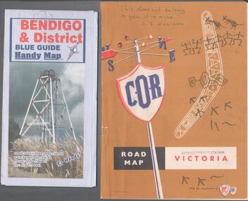 Bendigo Historical Society Inc.
Map - Road maps
... Map...Victoria...On, Bendigo & District blue guide handy map the other a road map of Victoria. ...On the back of the Bendigo map the date October 2000. On the Victoria map the words in pen "This doesn't belong to you, it is mine". ...On, Bendigo & District blue guide handy map the other a road map of Victoria. Map Road maps ...BHS CollectionTwo road maps. On, Bendigo & District blue guide handy map the other a road map of Victoria. On the back of the Bendigo map the date October 2000. On the Victoria map the words in pen "This doesn't belong to you, it is mine". L.J. Ellison and a blue stamp of Axedale service station. Aileen and John Ellison Collection.road map, victoria, bendigo -
 Stanley Athenaeum & Public Room
Administrative record - Old bank books, Bank Books - Athenaeum Committee No.610-01346
... State Bank books with light blue/dark blue covers with picture of map of Victoria on front cover....Transactions for 'Athenaeum Committee Stanley' State Bank books with light blue/dark blue covers with picture of map of Victoria on front cover. Bank Books - Athenaeum Committee No.610-01346 Administrative record Old bank books ...State Bank books with light blue/dark blue covers with picture of map of Victoria on front cover.State Bank of Victoria - 26 Jan 1972 - 12 Jun 1974. Transactions for 'Athenaeum Committee Stanley' -
 Stanley Athenaeum & Public Room
Administrative record - Old bank books, Bank Books - Athenaeum Committee No.610-01346
... State Bank books with light blue/dark blue covers with picture of map of Victoria on front cover....Transactions for 'Athenaeum Committee Stanley' State Bank books with light blue/dark blue covers with picture of map of Victoria on front cover. Bank Books - Athenaeum Committee No.610-01346 Administrative record Old bank books ...State Bank books with light blue/dark blue covers with picture of map of Victoria on front cover.State Bank of Victoria - 12 Jun 1974 - 16 Jul 1976. Transactions for 'Athenaeum Committee Stanley'