Showing 104 items matching "measuring distance"
-
 Bendigo Military Museum
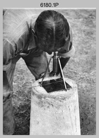
Photograph - Royal Australian Survey Corps Electronic Distance Measuring Equipment Demonstration, c1960s
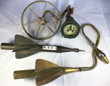
... Royal Australian Survey Corps Electronic Distance Measuring Equipment Demonstration. ...Royal Australian Survey Corps Electronic Distance Measuring Equipment Demonstration. ...Royal Australian Survey Corps Electronic Distance Measuring Equipment Demonstration. Photograph Royal Australian Survey Corps Electronic Distance Measuring Equipment Demonstration. ...This is a set of five photographs of CAPT James ‘Jim’ Leslie Stedman in the field demonstrating the setup of prisms used as electric distance measurement (EDM) receiver reflectors for tellurometer equipment and the sighting of a large surveyor’s light. This equipment was deployed in establishing mapping and geodetic control operations. The photos were most likely taken in the late 1950s or early 1960s. The tellurometers of this era were man-portable systems that improved geodetic survey efficiencies for rapid network extension and densification replacing triangulation with EDM and theodolite traverse sometimes using Bilby Towers to extend line lengths. Jim Stedman later reached the rank of Colonel, was Director of Military Survey from 1975 to 1978 and was appointed as Colonel Commandant (honorary appointment, Retd) of the Royal Australian Survey Corps from 1978 to 1983. Jim Stedman is demonstrating EDM equipment. See item 6180.16P, photos .14) to .16) for more information and photos of Jim Stedman’s EDM demonstration. This is a set of five photographs of a surveyor in the field demonstrating electric distance measurement (EDM) equipment. c1950s – 1960s. The photographs were printed on photographic paper and are part of the Army Survey Regiment’s Collection. The photographs were scanned at 300 dpi. .1) to .2) - Photo, black & white, c1960s, CAPT Jim Stedman demonstrating the sighting of a large surveyor’s light. .3) to .5) – Photo, black & white, c1960s, CAPT Jim Stedman demonstrating EDM prism equipment. .1P to .5P on back – CAPT Stedman EDM Eqpt.royal australian survey corps, rasvy, army survey regiment, army svy regt, fortuna, asr, surveying -
 Moorabbin Air Museum
Manual (Item) - KDM 7000B Distance Measuring Equipment System Bendix/King General Avionics Division
... KDM 7000B Distance Measuring Equipment System Bendix/King General Avionics Division...KDM 7000B Distance Measuring Equipment System Bendix/King General Avionics Division...Moorabbin Air Museum Moorabbin Airport 12 First Street Moorabbin melbourne Manual Number 006-00155-0003 KDM 7000B Distance Measuring Equipment System Bendix/King General Avionics Division Manual KDM 7000B Distance Measuring Equipment System Bendix/King General Avionics Division ...Manual Number 006-00155-0003 -
Moorabbin Air Museum
Booklet (item) - Operational Notes on Distance Measuring Equipment Commonwealth of Australia Department of Civil Aviation DCA Publication No. 24, Operational Notes on Distance Measuring Equipment
... Operational Notes on Distance Measuring Equipment Commonwealth of Australia Department of Civil Aviation DCA Publication No. 24...Operational Notes on Distance Measuring Equipment...Moorabbin Air Museum Moorabbin Airport 12 First Street Moorabbin melbourne Operational Notes on Distance Measuring Equipment Booklet Operational Notes on Distance Measuring Equipment Commonwealth of Australia Department of Civil Aviation DCA Publication No. 24 ... -
Moorabbin Air Museum
Manual (item) - Nomad Distance Measuring System ?Maintenance Manual
... Nomad Distance Measuring System ?Maintenance Manual...Nomad Distance Measuring System ?Maintenance Manual...Moorabbin Air Museum Moorabbin Airport 12 First Street Moorabbin melbourne Nomad Distance Measuring System ?Maintenance Manual Manual Nomad Distance Measuring System ? ... -
Moorabbin Air Museum
Manual (Item) - King Instruction Manual KN-60 Distance Measuring Equipment
... King Instruction Manual KN-60 Distance Measuring Equipment...King Instruction Manual KN-60 Distance Measuring Equipment...Moorabbin Air Museum Moorabbin Airport 12 First Street Moorabbin melbourne King Instruction Manual KN-60 Distance Measuring Equipment Manual King Instruction Manual KN-60 Distance Measuring Equipment ... -
Moorabbin Air Museum
Manual (Item) - Bendix/King Distance Measuring Equipment Installation Manual, KN 63 Distance Measuring Equipment Installation Manual
... Bendix/King Distance Measuring Equipment Installation Manual...KN 63 Distance Measuring Equipment Installation Manual...Moorabbin Air Museum Moorabbin Airport 12 First Street Moorabbin melbourne Soft-cover manual with clear front cover KN 63 Distance Measuring Equipment Installation Manual Manual Bendix/King Distance Measuring Equipment Installation Manual ... -
Moorabbin Air Museum
Manual (Item) - King DIstance Measuring Equipment Maintenance/Overhaul Manual, Maintenance/Overhaul Manual KDM 705A Distance Measuring Equipment
... King DIstance Measuring Equipment Maintenance/Overhaul Manual...Maintenance/Overhaul Manual KDM 705A Distance Measuring Equipment...Moorabbin Air Museum Moorabbin Airport 12 First Street Moorabbin melbourne Soft-cover manual with clear front cover Maintenance/Overhaul Manual KDM 705A Distance Measuring Equipment Manual King DIstance Measuring Equipment Maintenance/Overhaul Manual ... -
Moorabbin Air Museum
Manual (Item) - King Distance Measuring Equipment Installation Manual, KN 62/62A/64 Distance Measuring Equipment Installation Manual
... King Distance Measuring Equipment Installation Manual...KN 62/62A/64 Distance Measuring Equipment Installation Manual...Moorabbin Air Museum Moorabbin Airport 12 First Street Moorabbin melbourne Soft-cover manual with clear front cover KN 62/62A/64 Distance Measuring Equipment Installation Manual Manual King Distance Measuring Equipment Installation Manual ... -
Moorabbin Air Museum
Manual (Item) - Bendix/King Distance Measuring Equipment Installation Manual, Installation Manual KDM 706/706A Distance Measuring Equipment
... Bendix/King Distance Measuring Equipment Installation Manual...Installation Manual KDM 706/706A Distance Measuring Equipment...Moorabbin Air Museum Moorabbin Airport 12 First Street Moorabbin melbourne Soft-cover manual with clear front cover Installation Manual KDM 706/706A Distance Measuring Equipment Manual Bendix/King Distance Measuring Equipment Installation Manual ... -
 National Vietnam Veterans Museum (NVVM)
Booklet, Australian Army, British Army: Directions for the Use of Aartillery Instruments : Pamphlet No. 9: Distance Measuring Equipment MRA 2 (Tellurometer), 1961 (Copy 2), 1961
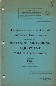
... British Army: Directions for the Use of Aartillery Instruments : Pamphlet No. 9: Distance Measuring Equipment MRA 2 (Tellurometer), 1961 (Copy 2)......Distance Measuring Equipment...British Army: Directions for the Use of Aartillery Instruments : Pamphlet No. 9: Distance Measuring Equipment MRA 2 (Tellurometer), 1961 (Copy 2) Booklet Australian Army British Army ...A blue coloured cardboard cover. the information is written in black ink. Top right hand corner is the number five which has been written in black texta. Une this is W.O. Code No. 9726. Part of the top half of the cover is faded. There are three punch holes and two metal staples down the left hand side. Also contains Amendments No. 1 which is held together by a metal staple and is inside of the booklet. Top right hand corner reads 7610-66-013-9800/1. Under this reads W Code No 9726-2 (Aust) and this amendment is done by Army Headquaters, Canberra on the 1 Sep. 68. There are three punch holes down the left hand side of the amendment.australia - armed forces - service manuals, british army, artillery instruments, distance measuring equipment, tellurometer -
 National Vietnam Veterans Museum (NVVM)
Booklet, Australian Army, British Army: Directions for the Use of Aartillery Instruments : Pamphlet No. 9: Distance Measuring Equipment MRA 2 (Tellurometer), 1961 (Copy 1), 1961
... British Army: Directions for the Use of Aartillery Instruments : Pamphlet No. 9: Distance Measuring Equipment MRA 2 (Tellurometer), 1961 (Copy 1)......Distance Measuring Equipment...British Army: Directions for the Use of Aartillery Instruments : Pamphlet No. 9: Distance Measuring Equipment MRA 2 (Tellurometer), 1961 (Copy 1) Booklet Australian Army British Army ...A blue coloured cardboard cover. the information is written in black ink. Top right hand corner is the number four which has been written in black texta. Une this is W.O. Code No. 9726. The top half of the cover is faded. There are three punch holes and two metal staples down the left hand side. Also contains Amendments No. 1 which is held together by a metal staple and is inside of the booklet. Top right hand corner reads 7610-66-013-9800/1. Under this reads W Code No 9726-2 (Aust) and this amendment is done by Army Headquaters, Canberra on the 1 Sep. 68. There are three punch holes down the left hand side of the amendment.australia - armed forces - service manuals, british army, artillery instruments, distance measuring equipment, tellurometer -
 Queenscliffe Maritime Museum
Instrument - Trailing Ship's Log
... ...measuring distance...Metal trailing log comprising of a gauge and two rotors towed behind ships to measure distance....Metal trailing log comprising of a gauge and two rotors towed behind ships to measure distance. Instrument Trailing Ship's Log T.Walker ...Used to 1935 by John Gordon Hanby while in the militia at Fort Queenscliffe.Metal trailing log comprising of a gauge and two rotors towed behind ships to measure distance.Walker's, Cherve, Mark III.towing log, measuring distance, ship's log -
Moorabbin Air Museum
Manual (Item) - RTCA - Minimum performance standards airborne distance measuring equipment (DME) operating within radio frequency range of 960-1215 megahertz, RTCA Document DO-151A
... RTCA - Minimum performance standards airborne distance measuring equipment (DME) operating within radio frequency range of 960-1215 megahertz...Moorabbin Air Museum Moorabbin Airport 12 First Street Moorabbin melbourne RTCA Document DO-151A Manual RTCA - Minimum performance standards airborne distance measuring equipment (DME) operating within radio frequency range of 960-1215 megahertz ... -
Moorabbin Air Museum
Manual (Item) - Mark 5 Airborne distance measuring equipment, ARINC characteristic 709, 710, 711, 712, 713, 714, 715, 716, 717
... Mark 5 Airborne distance measuring equipment....Moorabbin Air Museum Moorabbin Airport 12 First Street Moorabbin melbourne ARINC characteristic 709, 710, 711, 712, 713, 714, 715, 716, 717 Manual Mark 5 Airborne distance measuring equipment. ... -
Moorabbin Air Museum
Document (Item) - includes, DME, distance measuring equipment, Nomad, Qantas 747, DC9, microwave, Ikara, Jindivik, fire rescue vehicles, Airtruk, Australian aerospace
... includes, DME, distance measuring equipment, Nomad, Qantas 747, DC9, microwave, Ikara, Jindivik, fire rescue vehicles, Airtruk, ...Moorabbin Air Museum Moorabbin Airport 12 First Street Moorabbin melbourne Australian aerospace Document includes, DME, distance measuring equipment, Nomad, Qantas 747, DC9, microwave, Ikara, Jindivik, fire rescue vehicles, Airtruk, ... -
 Bendigo Military Museum
Equipment - MAP MEASURER/OPISMETER, DEPOSE
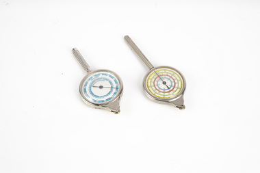
... Vintage opisometer used for measuring distances on maps. Part of the Kevin John Herdman, No. 397661, Collection. ...As it turns, the hand on the front dial turns to measure distance. .2) Rigid plastic rectangular storage case in two parts. ...As it turns, the hand on the front dial turns to measure distance. .2) Rigid plastic rectangular storage case in two parts. ...Vintage opisometer used for measuring distances on maps. Part of the Kevin John Herdman, No. 397661, Collection. See Catalogue No. 5942P for details of his service record..1) Circular chromed metal instrument with handle. Calibrated dial with black markings and hand on a white background. Reverse face has unit conversion details in black text on white background. Each face is covered with a convex glass lens. On the opposite end to the handle is a small wheel with milled edge. As it turns, the hand on the front dial turns to measure distance. .2) Rigid plastic rectangular storage case in two parts. Base is yellow, top is clear..1) Printed on front dial: 'INCHES, MADE IN FRANCE'. Printed on back dial: 'Unit conversion details'. Stamped on metal near wheel: 'DEPOSE, H(logo)B'. .2) Stamped on clear cover: 'CURVIMETRE, MAP MEASURER, H(logo)B, MADE IN FRANCE'.map, map measure, equipment, opisometer, kevin john herdman -
 Musculoskeletal Health Australia (now held by the Glen Eira Historical Society)
Photograph - Group photo
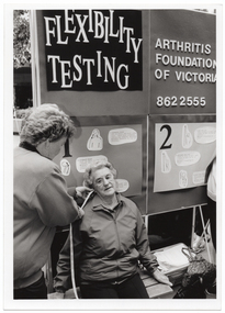
... Using a measuring tape, she measures the distance between a woman's ear and shoulder....B&W photo of a woman using a measuring tape to measure the distance between another woman's ear and shoulder. ...Using a measuring tape, she measures the distance between a woman's ear and shoulder. arthritis foundation of victoria afv rheumatism and arthritis association of victoria raav joint action team jag flexibility testing joint health muscle health muscle tension mobility movement assessment measurement B&W photo of a woman using a measuring tape to measure the distance between another woman's ear and shoulder. ...At an unidentified event, a member of the Joint Action Team staffs a Flexibility Testing stand. Using a measuring tape, she measures the distance between a woman's ear and shoulder.B&W photo of a woman using a measuring tape to measure the distance between another woman's ear and shoulder. Behind them is a display board with the words "Flexibility testing", "Arthritis Foundation of Victoria", the telephone number "862 2555", and various sketch drawings with corresponding text.arthritis foundation of victoria, afv, rheumatism and arthritis association of victoria, raav, joint action team, jag, flexibility testing, joint health, muscle health, muscle tension, mobility, movement, assessment, measurement -
 Department of Energy, Environment and Climate Action
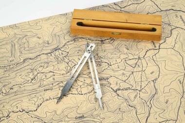
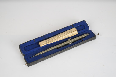
Mapping dividers
... used to measure distances on maps...Department of Energy, Environment and Climate Action 71-79 Kyle Road Altona North used to measure distances on maps Forests Commission Victoria (FCV) Forest measurement Surveying mapping Adjustable stainless steel mapping dividers with wooden box Mapping dividers ...used to measure distances on mapsAdjustable stainless steel mapping dividers with wooden boxforests commission victoria (fcv), forest measurement, surveying, mapping -
 Department of Energy, Environment and Climate Action
Mapping Dividers
... used to measure distances on maps...Department of Energy, Environment and Climate Action 71-79 Kyle Road Altona North used to measure distances on maps Forests Commission Victoria (FCV) Forest measurement Surveying mapping Adjustable stainless steel mapping dividers with wooden box Mapping Dividers ...used to measure distances on mapsAdjustable stainless steel mapping dividers with wooden boxforests commission victoria (fcv), forest measurement, surveying, mapping -
Moorabbin Air Museum
Manual - Lockheed Hercules technical training, Customer Training Electronics
... ...Distance measuring equipment...Moorabbin Air Museum Moorabbin Airport 12 First Street Moorabbin melbourne Lockheed Hercules technical training Equipment installation Gables intercommunication system Voice recorders Flight recorders Emergency transmitter HF/VHF Distance measuring equipment Beacon Transponder Altimeter Weather radar system Flight director system Magnetic compass Autopilot Doppler radar Technical overview of Hercules electronics systems, circa 1976 Customer Training Electronics Manual Lockheed Hercules technical training ...Technical overview of Hercules electronics systems, circa 1976non-fictionTechnical overview of Hercules electronics systems, circa 1976equipment installation, gables intercommunication system, voice recorders, flight recorders, emergency transmitter, hf/vhf, distance measuring equipment, beacon, transponder, altimeter, weather radar system, flight director system, magnetic compass, autopilot, doppler radar -
 Department of Energy, Environment and Climate Action
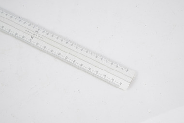
Mapping scale ruler
... Used to measure distance on scale maps...Department of Energy, Environment and Climate Action 71-79 Kyle Road Altona North Used to measure distance on scale maps Forests Commission Victoria (FCV) Surveying mapping W&G Scale ruler Mapping scale ruler ...Used to measure distance on scale mapsScale rulerW&G forests commission victoria (fcv), surveying, mapping -
 Department of Energy, Environment and Climate Action
HipChain Distance Measurer
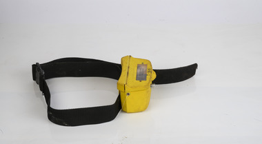
... HipChain Distance Measurer...Forest measurement Surveying HipChain Distance Measurer HipChain Distance Measurer ...Hipchains are a reliable tool for precise long distance measurement, particularly with irregular boundaries, in rough terrain or thick scrub To use, simply tie the cotton thread to a fixed object at your starting point, zero the counter, and start walking. As you move, the thread extends, turning the counter. The instrument attaches to your belt, keeping the thread taut and accurate. Once you reach your endpoint, break the thread and continue.HipChain Distance Measurerforest measurement, surveying -
 Department of Energy, Environment and Climate Action
map measuring wheels
... The map wheel is a simple, fast and accurate way to measure distances on maps, whether in straight lines or along curves. ...Department of Energy, Environment and Climate Action 71-79 Kyle Road Altona North The map wheel is a simple, fast and accurate way to measure distances on maps, whether in straight lines or along curves. ...The map wheel is a simple, fast and accurate way to measure distances on maps, whether in straight lines or along curves. Hold the device from the tip and trace with the small wheel at the bottom along the line to be measured Measures distances in miles, kilometres or nautical miles depending on the scale on the side.Two metal map measuring wheel sMap scales on each side of wheelforests commission victoria (fcv), surveying, mapping -
 Greensborough Historical Society
Ruler, Scale rule for map reading, 1950c
... Small rule to measure distance when reading a scale map. Measurements in yards or meters....Greensborough Historical Society 34A Glenauburn Road Lower Plenty Lower Plenty melbourne Small rule to measure distance when reading a scale map. Measurements in yards or meters. map reading scale ruler Small plastic rule, cream colour with black markings. ...Small rule to measure distance when reading a scale map. Measurements in yards or meters.Small plastic rule, cream colour with black markings.map reading, scale ruler -
 Greensborough Historical Society
Article, Anne Paul, Robert Hoddle - Chains and Grids in Terra Nullius, January 2024
... Article about Robert Hoddle, his work as a surveyor in early Melbourne and the use of the 'chain' to measure distance....Greensborough Historical Society 34A Glenauburn Road Lower Plenty Lower Plenty melbourne Article about Robert Hoddle, his work as a surveyor in early Melbourne and the use of the 'chain' to measure distance. Melbourne History Robert Hoddle 14 page article text and illus. ...Article about Robert Hoddle, his work as a surveyor in early Melbourne and the use of the 'chain' to measure distance.14 page article text and illus.melbourne history, robert hoddle -
 Bendigo Military Museum
Photograph - RASvy Surveyors in the field, c1950s – 1960s
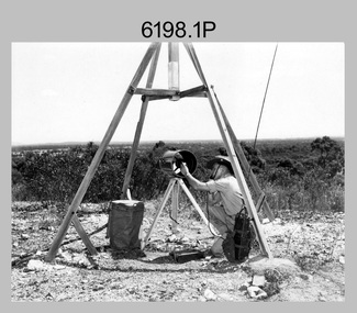
... The tellurometer in Photos .14P to .16P was a MRA1 microwave Electronic Distance Measuring instrument (EDM) introduced in 1958. ...This is a set of 17 photographs of surveyors in the field measuring distances using chains, taking observations using theodolites and operating electric distance measurement (EDM) equipment. c1950s – 1960s. ...The tellurometer in Photos .14P to .16P was a MRA1 microwave Electronic Distance Measuring instrument (EDM) introduced in 1958. ...This is a set of 1photographs of surveyors in the field measuring distances using chains, taking observations using theodolites and operating electric distance measurement equipment. They were probably employed in establishing mapping and geodetic control operations or the surveyors may have been in training. The photos were most likely taken in the 1950s and 1960s. Photos .1P to .6P feature personnel setting up geodetic survey chaining equipment to measure distances. The surveyor in Photo .5P is LTCOL Howard Angus Johnson MBE who served from 1936 to 1954. The RA Svy surveyor in photos .7P to .12P were using a theodolite to take angular measurements. They were usually supported by an observer who recording their readings on a booking form. The surveyor in Photo .10P and .11P is LTCOL Jorge Gruszka, who served from 1955 to 1985. He was CO of the Army Survey Regiment from 1982 to 1985. The surveyor in photo .13P is cutting an identification blaze on a tree using a hammer and chisel. The tellurometer in Photos .14P to .16P was a MRA1 microwave Electronic Distance Measuring instrument (EDM) introduced in 1958. It and later models were man-portable systems that improved geodetic survey efficiencies for rapid network extension and densification replacing triangulation with EDM and theodolite traverse sometimes using Bilby Towers to extend line lengths. The surveyor with the slouch hat is Colonel James ‘Jim’ Leslie Stedman, who served from 1941 to 1978. He was Director of Military Survey from 1975 to 1978 and was appointed as Colonel Commandant (honorary appointment, Retd) of the Royal Australian Survey Corps from 1978 to 1983. Jim Stedman is demonstrating EDM equipment.This is a set of 17 photographs of surveyors in the field measuring distances using chains, taking observations using theodolites and operating electric distance measurement (EDM) equipment. c1950s – 1960s. The photographs were printed on photographic paper and are part of the Army Survey Regiment’s Collection. The photographs were scanned at 300 dpi. .1) - Photo, black & white, c1950s, unidentified personnel using geodetic survey chaining equipment. .2) to .4) - Photo, black & white, c1950s, geodetic survey chaining equipment. .5) – Photo, black & white, c1950s, Jim Stedman using geodetic survey chaining equipment to measure distances. .6) - Photo, black & white, c1950s, Unidentified personnel geodetic survey chaining equipment. .7) – Photo, black & white, mounted on card, c1950s. Unidentified surveyor undertaking observations on a coral reef using a theodolite. .8) – Photo, black & white, c1950, unidentified surveyor undertaking observations with a Tavistock theodolite. .9) – Photo, black & white, mounted on green card, c1950s. Unidentified surveyor undertaking observations using a plane table. .10) – Photo, black & white, c1955, Jorge Gruszka undertaking observations with a theodolite. 7/55 Basic Survey Course Balcombe. .11) – Photo, black & white, c1950s, Jorge Gruszka undertaking observations with a theodolite. .12) – Photo, black & white, c1946-1948, unidentified surveyor undertaking observations with a theodolite to gain control for the mapping of the Snowy Mountain Diversion Scheme. .13) – Photo, black & white, c1950s, unidentified surveyor cutting a blaze in a tree. .14) and .15) – Photo, black & white, c1960s, Jim Stedman demonstrating EDM equipment. .16) – Photo, black & white, c1960s, L to R: Jim Stedman (probably) and unidentified surveyor demonstrating EDM equipment. .17) – Photo, black & white, 1956, Operation Cutlass - Surveyors SPR W. Crane and J.A. Campbell undertaking observations with a theodolite in extreme conditions..1P on back - First Order Chaining Equipment .2P on back - First Order Chaining Equipment .3P on back - Full catenary 1800 – 1960 replaced by EDM .4P on back - First Order Chaining Equipment .5P on back - H.A. Johnson, Benambra baseline? 1st Order Chaining .6P on back - Chaining .7P on front - Difficult observing conditions especially when the tide is in. The station is sighted (sic) on a coral reef. .8P on back - Tavistock. .10P on back of duplicate in Photo Folder 14 – George (sic) Gruszka 7/55 Basic Survey Course Balcomme (sic) 1955/56 .14P and .15P on back - Jim Stedman demonstrating early EDM equipment.royal australian survey corps, rasvy, army survey regiment, army svy regt, fortuna, asr, surveying -
Creswick Campus Historical Collection - University of Melbourne
Equipment, Curvimeter
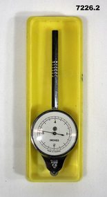
... Steel tool with moving wheel attached to measurement dial. For measuring distance of irregular line on maps. Cased in blue box with clear lid...Creswick Campus Historical Collection - University of Melbourne 4 Water Street University of Melbourne Creswick Campus Building 719/718 Creswick goldfields Steel tool with moving wheel attached to measurement dial. For measuring distance of irregular line on maps. Cased in blue box with clear lid Equipment Curvimeter Equipment ...Steel tool with moving wheel attached to measurement dial. For measuring distance of irregular line on maps. Cased in blue box with clear lidEquipment -
Frankston RSL Sub Branch
Rule, Scale, E. ESDAILE & SONS, 1942
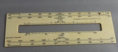
... A scale rule used by artillery units to measure distance between map co-ordinates on the 1 to 25,000 scale military map series. ...Frankston RSL Sub Branch 183 Cranbourne Road Frankston mornington-peninsula artillery rule scale imperial metric distance world war 2 ww2 The rule is stamped with the following: "SCALE, ARTY, No 2, MKI, E.ESDAILE & SONS, D^D, 1942" A scale rule used by artillery units to measure distance between map co-ordinates on the 1 to 25,000 scale military map series. ...A scale rule used by artillery units to measure distance between map co-ordinates on the 1 to 25,000 scale military map series. The rule is accurately machined from flat stainless steel strip and is stamped with Imperial measurements (thousands of yards) and metric measurements (thousands of metres).The rule is stamped with the following: "SCALE, ARTY, No 2, MKI, E.ESDAILE & SONS, D^D, 1942"artillery, rule, scale, imperial, metric, distance, world war 2, ww2, -
 Melbourne Legacy
Ceremonial object, Military Pace Stick
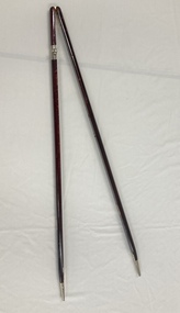
... A pace stick is a training instrument used to gauge the length of pace and measure distance and interval for military parades. ...A pace stick is a training instrument used to gauge the length of pace and measure distance and interval for military parades. ...A hinged wooden stick that is used in military situations. It is kept in the Comradeship Lounge as a link to the legatees' military background. A pace stick is a training instrument used to gauge the length of pace and measure distance and interval for military parades. Legacy has a strong link to the military, most early legatees would be familiar with the pace stick and its use.Wooden stick that is hinged, has metal tips and is used as a pace tool.comradeship, pace stick -
 Bendigo Military Museum
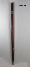
Uniform - PACE STICK, ARMY, Australian Defence Industries, Unknown
... Pace stick - a training instrument used to gauge the length of pace and measure distance and interval for military parades and military situations. ...Bendigo Military Museum 37 - 39 Pall Mall Bendigo goldfields Pace stick - a training instrument used to gauge the length of pace and measure distance and interval for military parades and military situations. ...Pace stick - a training instrument used to gauge the length of pace and measure distance and interval for military parades and military situations. Pace stick issued to G. WESTHEAD, No. 317595/8233929. Refer Cat No. 1496.7 for Service Records.Pace stick, two pieces of timber with brown stain and gloss varnish, brass metal hinge at the top. Two silver colour metal tips at bottom. Silver colour metal fittings along length of timber sticks are used to set a particular distance.uniform, army, pace stick, military police, g. westhead