Showing 6465 items matching "melbourne area."
-
 NMIT (Northern Melbourne Institute of TAFE)
Report: Future directions for TAFE in the inner urban area of Melbourne 1983
... Report: Future directions for TAFE in the inner urban area of Melbourne 1983...Report: Future directions for TAFE in the inner urban area of Melbourne 1983...Bound A4 size report of 244 pages and full title on the cover is 'Final report to the TAFE Board on / Future directions for TAFE / in the inner urban area / of Melbourne / October, 1983. Report to the Technical and Further Education Board, Victoria....Report: Future directions for TAFE in the inner urban area of Melbourne 1983 Report: Future directions for TAFE in the inner urban area of Melbourne 1983 ...Bound A4 size report of 244 pages and full title on the cover is 'Final report to the TAFE Board on / Future directions for TAFE / in the inner urban area / of Melbourne / October, 1983. Report to the Technical and Further Education Board, Victoria.technical and further education board victoria, tafe -
Port Melbourne Historical & Preservation Society
Photograph - Port Melbourne beach area and Port Melbourne Town Hall, Alison Kelly, 1985
... Port Melbourne beach area and Port Melbourne Town Hall...Fifty two (52) transparency slides of the Port Melbourne beach area and Port Melbourne Town Hall...Port Melbourne Historical & Preservation Society Port Melbourne Town Hall 333 Bay Street Port Melbourne melbourne Beacons Natural Environment - Beaches and Foreshore Built Environment - Civic Port Melbourne Town Hall Fifty two (52) transparency slides of the Port Melbourne beach area and Port Melbourne Town Hall Photograph Port Melbourne beach area and Port Melbourne Town Hall Alison Kelly ...Fifty two (52) transparency slides of the Port Melbourne beach area and Port Melbourne Town Hallbeacons, natural environment - beaches and foreshore, built environment - civic, port melbourne town hall -
 Eltham District Historical Society Inc
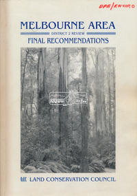
Book, Land Conservation Council, Melbourne Area, District 2 Review: Final Recommendations, 1994
... Melbourne Area, District 2 Review: Final Recommendations...Timber resources and water quality and yield from timbered catchment areas remained significant issues in Melbourne’s catchments. Recommendations for the Yarra Ranges National Park were based around the closed Melbourne water catchments and adjoining state forest. ...Also inserted loose in book brochure for invitation of submissions till 25 Nov 1991 and AO size colour map (folded) Proposed Recommendations Melbourne Area, District 2 Review: Final Recommendations Book Book Land Conservation Council ...Notices showing the boundary of the area of the review and advising that an investigation was to be carried out were published in the Victoria Government Gazette and in local and other Victorian newspapers in May 1987. A descriptive resources report was published in August 1991. Council received 1,425 submissions and letters following publication of the descriptive report. The Council considered these submissions and published proposed recommendations in April 1993. A further 1,993 submissions were received in response to the proposed recommendations. The Council published its final recommendations in July 1994. A change to legislation in 1989 enabled the LCC to make recommendations for public land within a ‘town’, though cities and rural cities remained excluded from the definition of public land. Timber resources and water quality and yield from timbered catchment areas remained significant issues in Melbourne’s catchments. Recommendations for the Yarra Ranges National Park were based around the closed Melbourne water catchments and adjoining state forest. A recommended Phillip Island State Park based around the penguin reserve was ultimately implemented as the Phillip Island Nature Park.Shire of Nillumbik DPE/Enviro -
Save the Dandenongs League Inc.
Archive (item), Save the Dandenongs League Incorporated, Melbourne Area District 2 Review Descriptive Report - Land Conservation Council
... Melbourne Area District 2 Review Descriptive Report - Land Conservation Council...Melbourne Area District 2 Review Descriptive Report - Land Conservation Council Archive Save the Dandenongs League Incorporated ... -
 Victorian Aboriginal Corporation for Languages
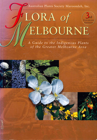
Book, Marilyn Gray, Flora of Melbourne : a guide to the indigenous plants of the greater Melbourne area, 2001
... Flora of Melbourne : a guide to the indigenous plants of the greater Melbourne area...Flora of Melbourne : a guide to the indigenous plants of the greater Melbourne area Book Marilyn Gray John Knight Australian Plant Society Maroondah ...Comprehensive book giving illustration of plants and very specific, detailed descriptions.Colour photographs, illustrations, mapsindigenous plants, werribee river, mount evelyn, sunbury, mount eliza, botany, plant associations, park regeneration, propagation, weeds -
Koorie Heritage Trust
Book, Beauglehole, A. C, The distribution and conservation of vascular plants in the Melbourne area, Victoria, 1983
... The distribution and conservation of vascular plants in the Melbourne area, Victoria...The distribution and conservation of vascular plants in the Melbourne area, Victoria Book Beauglehole, A. C. ...iii, 156 p. : ill. ; 22 x 30 cm. + 1 folded col. map.indigenous vascular plants. distribution. melbourne region | botany -- victoria -- melbourne region. -
 Sunshine and District Historical Society Incorporated
Photograph - Aerial Photographs Of Melbourne Metropolitan Area 1989, Qascophoto, 17th November 1989 & 28th November 1989
... Aerial Photographs Of Melbourne Metropolitan Area 1989...McKay Trade Wing, Tottenham Hotel, Sunshine Carvan Park 953.14 - Aerial Photographs Of Melbourne Metropolitan Area 1989.JPG Suburb(s): Derrimut, Mt. ...McKay Trade Wing, Tottenham Hotel, Sunshine Carvan Park 953.14 - Aerial Photographs Of Melbourne Metropolitan Area 1989.JPG Suburb(s): Derrimut, Mt. ...953.01 - Aerial Photographs Of Melbourne Metropolitan Area 1989.JPG Suburb(s): Ardeer, Deer Park (Now Derrimut), Sunshine West Area bounded by: Railway Parade (North), Paramount Bouvard (South), Allison Street (East), Approx Station Road (West) Points of Interest: IVI Explosive Bunkers, Railway Siding into ICI off Forrest Street, Former Railway Station Tilburn Road, Sunshine Technical School Annex, Croatian Catholic Centre Sunshine Fitzgerald Road 953.02 - Aerial Photographs Of Melbourne Metropolitan Area 1989.JPG Suburb(s): Brooklyn, Yarraville Area bounded by: South of Somerville Road (North), Westgate Freeway (South), Urwin Street (East). West of McDonald Road (West) Points of Interest: State Electricity Commission of Victoria (SECV) Stores, Brooklyn Wool Stores, Brooklyn Primary School, Half Moon Caravan Park, Footscray Cemetery, Rheems, James Hardy 953.03 - Aerial Photographs Of Melbourne Metropolitan Area 1989.JPG Suburb(s): Ascot Vale, Maribyrnong Area bounded by: Raleigh Road (North), River Street and James Street (South), Holdsworth Street (East), West of Van Ness Avenue (West) Points of Interest: Highpoint City, Fairbairn Park, Hume Pipes, Riverside Golf Course, ICI Laboratories 953.04 - Aerial Photographs Of Melbourne Metropolitan Area 1989.JPG Suburb(s): Albion, Ardeer, Sunshine, Sunshine West Area bounded by: Dubbo Street (North), South of Glengala Road (South), West of Sydney Street (East), Vernon Crescent (West) Points of Interest: Ainsworth Reserve, Selwyn Park, St. Paul Church, Marian College, Ardeer Primary School, Glengala Road Shopping Centre, 953.05 - Aerial Photographs Of Melbourne Metropolitan Area 1989.JPG Suburb(s): Deer Park Area bounded by: Station Road (East), Marcellin Court (West), Irvine Street (North), Deer Street (South) Points of Interest: Deer Park Primary School, Deer Park Play Kindergaten, Deer Park Shopping Centre, St. Peter Chanel Church & School 953.06 - Aerial Photographs Of Melbourne Metropolitan Area 1989.JPG Suburb(s): Derrimut Area bounded by: Future Ring Road (North), South of Boundary Road (South), East of Andersons Swamp (East), West of Fitzgerald Road (West) Points of Interest: Andersons Swamp 953.07 - Aerial Photographs Of Melbourne Metropolitan Area 1989.JPG Suburb(s): Sunshine West Area bounded by: East of Fairbairn Road (East), East of Fitzgerald Road (West), North of Mailey Street (North), South of Talintyre Road (South) Points of Interest: Sunshine West High School, Sunshine Heights Primary School, Castley Reserve, Talintyre Reserve, Talintyre Road Shops, St. Peters School, Sunshine Golf Course, Ralph Reserve, Glengala Primary School 953.08 - Aerial Photographs Of Melbourne Metropolitan Area 1989.JPG Suburb(s): Derrimut, Ravenhall Area bounded by: East of Station Road, now Derrimut Road (East), West of Robinsons Road (West), South of Railway Line (North), North of Future Deer Park Bypass Points of Interest: Old Farms and Quarries 953.09 - Aerial Photographs Of Melbourne Metropolitan Area 1989.JPG Suburb(s): Sydenham, Taylors Lakes, Taylors Hill Area bounded by: Taylors Creek (North), Future Hume Drive (South), West of Future Parmelia Drive (East), Future Hawthorn Grove (West) Points of Interest: Sydenham Reservoir, Sydenham Railway Station, Sydenham Memorial Hall, Sydenham Primary School, Sydenham Recreation Reserve, Catholic Regional College Sydenham, Kingdom Hall of Jehovah's Witnesses 953.10 - Aerial Photographs Of Melbourne Metropolitan Area 1989.JPG Suburb(s): Brooklyn, Tottenham Area bounded by: Stony Creek (North), South of Somerville Road (South), Holmwood Road (East), West of McDonald Road (West) Points of Interest: Monsanto, Dalgety's, Wool Stores, Sims Metals, Farmer & Graziers, Olex Cables, Redbrook Carpets, May & Baker, Cargil Oil, Smorgans 953.11 - Aerial Photographs Of Melbourne Metropolitan Area 1989.JPG Suburb(s): Brooklyn Area bounded by: South of Fourth Avenue (North), South of Bunting Road (South), West of McDonald Road, East of Fitzgerald Road (West) Points of Interest: Market Road, Bunting & Jones Road Quarries, Monsanto, ANI, Market Timber 953.12 - Aerial Photographs Of Melbourne Metropolitan Area 1989.JPG Suburb(s): Brooklyn, Laverton North Area bounded by: South of Bunting Road (North), Buchanan Road (South), Cypress Avenue (East). Little Boundary Road (West) Points of Interest: Jones Road and Old Geelong Road Quarries, Brooklyn Go Kart Track, Sims Metal Foundry, Ralphs, Guiding Star Hotel, Gas & Fuel Substation 953.13 - Aerial Photographs Of Melbourne Metropolitan Area 1989.JPG Suburb(s): Sunshine, Sunshine West Area bounded by: Parsons Street (North), South of Fourth Avenue (South), Alfred Street (East), West of Kororoit Creek (West) Points of Interest: Parsons Reserve, Wheat Silos, H.V. McKay Trade Wing, Tottenham Hotel, Sunshine Carvan Park 953.14 - Aerial Photographs Of Melbourne Metropolitan Area 1989.JPG Suburb(s): Derrimut, Mt. Derrimut, Sunshine West, Area bounded by: East of Allison Street (East), Mt. Derrimut (West), Hilma Street (North), South of old Sunshine Golf Course (South) Points of Interest: Mt. Derrimut, Sunshine Golf Course 953.15 - Aerial Photographs Of Melbourne Metropolitan Area 1989.jpeg Suburb(s): Avondale Height, Braybrook, Sunshine North Area bounded by: Canning Street (North), North of Cranwell Street (South), Medway Golf Course (East), Nottingham Street (West) Points of Interest: Duke Street Quarries, Cranwell Park, Pennell Reserve 953.16 - Aerial Photographs Of Melbourne Metropolitan Area 1989.jpeg Suburb(s): All of City of Sunshine Area bounded by: Maribyrnong River (North), Westgate Freeway (South), Nicholson Street (East), Robinsons Road (West) Points of Interest: General overall of the City of Sunshine 953.17 - Aerial Photographs Of Melbourne Metropolitan Area 1989.jpeg Map is missing 953.18 - Aerial Photographs Of Melbourne Metropolitan Area 1989.jpeg Suburb(s): Braybrook, Maidstone, Sunshine Area bounded by: Ballarat Road (North), North of South Road (South), East of Ashley Street (East), West of Duke Street (West) Points of Interest: Skinner Reserve, Kinder Smith Reserve, Churchill Avenue Shops, St. John College, Industrial Engineering, Invita Carpets, Tottenham Technical School, Carolone Chisholm College, Christ The King Primary School, Sunshine East Primary School, Dyecraft 953.19 - Aerial Photographs Of Melbourne Metropolitan Area 1989.JPG Suburb(s): Laverton North, Sunshine West Area bounded by: North of Boundary Road (North), Sewer Out Fall (South), East of Little Boundary Road (East), East of Future Ring Road (West). Points of Interest: Factories in Laverton Northmelbourne, aerial photograph -
 Eltham District Historical Society Inc
Book, Land Conservation Council, Report on the Melbourne Study Area, December 1973
... Report on the Melbourne Study Area...This report sets out to describe and assess the natural resources of the public lands in the Melbourne area and provides a factual basis on which members of the community may base submissions to the [Land Conservation] Council" - Foreword....This report sets out to describe and assess the natural resources of the public lands in the Melbourne area and provides a factual basis on which members of the community may base submissions to the [Land Conservation] Council of Victoria. 444 pages Report on the Melbourne Study Area Book Land Conservation Council ...This report is one of a series describings the physical nature of the land and its environment, examines the likely forms of land use, and assesses the hazards associated with these uses. It is divided into four main sections: Introduction, Characteristics of environment, main forms of land use and description of 24 specific blocks in the study area which include Torquay, Brisbane Ranges, Werribee, Wombat, Loddon, Romsey, Puckapunyal, Strathbogie, Eildon, Disappointment, Break O'Day, Black Range, Cerberean, Upper Goulburn, Kinglake, Donna Buang, Upper Yarra, Thomson, Dandenongs, Bunyip-Latrobe, Shady Creek, Tyers, Westernport and Strzelecki. The Land Conservation Act 1970 established the Land Conservation Council whose functions is to "carry out investigations and make recommendations to the Minister with respect to the use of public land in order to provide for the balanced use of land in Victoria. This report sets out to describe and assess the natural resources of the public lands in the Melbourne area and provides a factual basis on which members of the community may base submissions to the [Land Conservation] Council of Victoria.444 pagesnon-fictionThis report is one of a series describings the physical nature of the land and its environment, examines the likely forms of land use, and assesses the hazards associated with these uses. It is divided into four main sections: Introduction, Characteristics of environment, main forms of land use and description of 24 specific blocks in the study area which include Torquay, Brisbane Ranges, Werribee, Wombat, Loddon, Romsey, Puckapunyal, Strathbogie, Eildon, Disappointment, Break O'Day, Black Range, Cerberean, Upper Goulburn, Kinglake, Donna Buang, Upper Yarra, Thomson, Dandenongs, Bunyip-Latrobe, Shady Creek, Tyers, Westernport and Strzelecki. The Land Conservation Act 1970 established the Land Conservation Council whose functions is to "carry out investigations and make recommendations to the Minister with respect to the use of public land in order to provide for the balanced use of land in Victoria. This report sets out to describe and assess the natural resources of the public lands in the Melbourne area and provides a factual basis on which members of the community may base submissions to the [Land Conservation] Council of Victoria.land use, kinglake, thomson valley, conservation, public lands -
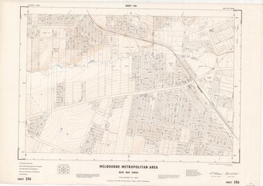
 Ringwood and District Historical Society
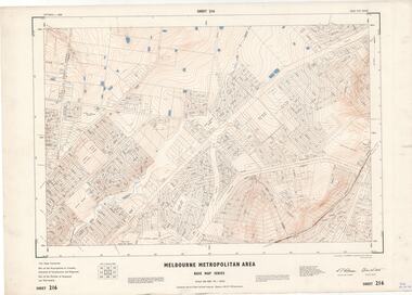
Map - Melbourne Metropolitan Area Base Map Series, Sheet 215 - Ringwood area, 1967
... Melbourne Metropolitan Area Base Map Series..., 1967 Map Melbourne Metropolitan Area Base Map Series ...Map prepared by Dept of Lands and Survey and MMBW from State Aerial Survey June 1957 and Cadastral Survey information July 1967. This sheet comprises parts of Municipalities of Doncaster & Templestowe, Nunawading and Ringwood, and Parishes of Nunawading and Warrandyte.Scale: 400 feet to 1 inch. Contours at 5 feet vertical interval. By Authority: A.C. Brooks, Commonwealth Printer, Melbourne. -
 Ringwood and District Historical Society
Map - Melbourne Metropolitan Area Base Map Series, Sheet 216 - Ringwood area, 1967
... Melbourne Metropolitan Area Base Map Series..., 1967 Map Melbourne Metropolitan Area Base Map Series ...Map prepared by Dept of Lands and Survey and MMBW from State Aerial Survey June 1957 and Cadastral Survey information July 1967. This sheet comprises parts of Municipalities of Croydon, Doncaster & Templestowe, and Ringwood, and Parishes of Ringwood and Warrandyte.Scale: 400 feet to 1 inch. Contours at 5 feet vertical interval. By Authority: A.C. Brooks, Commonwealth Printer, Melbourne. -
 Ringwood and District Historical Society
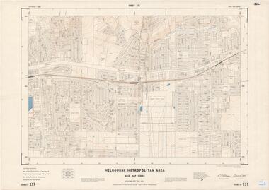
Map - Melbourne Metropolitan Area Base Map Series, Sheet 235 - Ringwood area, 1960
... Melbourne Metropolitan Area Base Map Series..., 1960 Map Melbourne Metropolitan Area Base Map Series ...Map prepared by Dept of Lands and Survey and MMBW from State Aerial Survey June 1957 and Cadastral Survey information August 1960. This sheet comprises parts of Municipalities of Doncaster & Templestowe, Nunawading and Ringwood, and Parishes of Nunawading, Ringwood and Warrandyte.Scale: 400 feet to 1 inch. Contours at 5 feet vertical interval. By Authority: A.C. Brooks, Commonwealth Printer, Melbourne. -
 Ringwood and District Historical Society
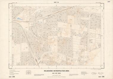
Map - Melbourne Metropolitan Area Base Map Series, Sheet 236 - Ringwood area, 1961
... Melbourne Metropolitan Area Base Map Series..., 1961 Map Melbourne Metropolitan Area Base Map Series ...Map prepared by Dept of Lands and Survey and MMBW from State Aerial Survey June 1957 and Cadastral Survey information May 1961. This sheet comprises parts of the Municipalities of Croydon and Ringwood, and Parishes of Ringwood and Warrandyte.Scale: 400 feet to 1 inch. Contours at 5 feet vertical interval. By Authority: A.C. Brooks, Commonwealth Printer, Melbourne. -
 Ringwood and District Historical Society
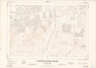
Map - Melbourne Metropolitan Area Base Map Series, Sheet 255 - Ringwood area, 1963
... Melbourne Metropolitan Area Base Map Series..., 1963 Map Melbourne Metropolitan Area Base Map Series ...Map prepared by Dept of Lands and Survey and MMBW from State Aerial Survey December 1956 and Cadastral Survey information May 1963. This sheet comprises parts of the Municipalities of Ferntree Gully, Nunawading and Ringwood, and Parishes of Nunawading, Ringwood and Scoresby.Scale: 400 feet to 1 inch. Contours at 5 feet vertical interval. By Authority: A.C. Brooks, Commonwealth Printer, Melbourne. -
 Ringwood and District Historical Society
Map - Melbourne Metropolitan Area Base Map Series, Sheet 256 - Ringwood area, 1962
... Melbourne Metropolitan Area Base Map Series..., 1962 Map Melbourne Metropolitan Area Base Map Series ...Map prepared by Dept of Lands and Survey and MMBW from State Aerial Survey December 1956 and Cadastral Survey information December 1962. This sheet comprises parts of the Municipalities of Croydon, Ferntree Gully, and Ringwood, and Parishes of Ringwood and Scoresby.Scale: 400 feet to 1 inch. Contours at 5 feet vertical interval. By Authority: A.C. Brooks, Commonwealth Printer, Melbourne. -
 Melbourne Tram Museum
Document - Report, Melbourne & Metropolitan Tramways Board (MMTB), 'Current trends which may indicate the future growth and nature of the metropolitan area and in particular the Central Business area of Melbourne", Jan. 1966
... 'Current trends which may indicate the future growth and nature of the metropolitan area and in particular the Central Business area of Melbourne"...Report - Foolscap, card covers, red binding strip, about pages + drawings or charts, titled 'Current trends which may indicate the future growth and nature of the metropolitan area and in particular the Central Business area of Melbourne" Has three parts: 1 - Future growth of population of the Melbourne Metropolitan Area 2 - The Centre of Gravity of and general distribution of the Central Business area of Melbourne 3 - Future growth of the Central Business Area of Melbourne. ...Melbourne Planning Development Has "JEC" in pencil on top right hand corner. Report - Foolscap, card covers, red binding strip, about pages + drawings or charts, titled 'Current trends which may indicate the future growth and nature of the metropolitan area and in particular the Central Business area of Melbourne" Has three parts: 1 - Future growth of population of the Melbourne Metropolitan Area 2 - The Centre of Gravity of and general distribution of the Central Business area of Melbourne 3 - Future growth of the Central Business Area of Melbourne. ...Report - Foolscap, card covers, red binding strip, about pages + drawings or charts, titled 'Current trends which may indicate the future growth and nature of the metropolitan area and in particular the Central Business area of Melbourne" Has three parts: 1 - Future growth of population of the Melbourne Metropolitan Area 2 - The Centre of Gravity of and general distribution of the Central Business area of Melbourne 3 - Future growth of the Central Business Area of Melbourne. Dated Jan 1966, prior to the construction of the Underground Railway and the move to Docklands.Has "JEC" in pencil on top right hand corner.trams, tramways, melbourne, planning, development -
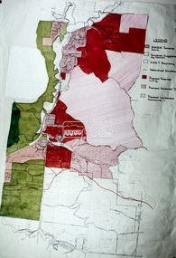
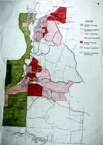
![Book - Map, Land Conservation Council, Melbourne Study Area Report, [December 1973]](/media/collectors/4f729f7b97f83e03086018a5/items/6469bc241d76dd4b008a829f/item-media/646b0013d841f8920fa4323c/item-fit-380x285.jpg?cb=6) Eltham District Historical Society Inc
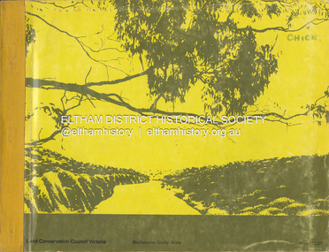
Eltham District Historical Society IncBook - Map, Land Conservation Council, Melbourne Study Area Report, [December 1973]
... Melbourne Study Area Report...A collection of eight large fold out coloured maps published in a bound book form Melbourne Study Area Report Book Map Land Conservation Council ...The Melbourne Study Report is a series of volumes describing the physical nature of the land and its environment, examines the likely forms of land use, and assesses the hazards associated with these uses. This is Volume 2 (coloured maps). The first page featues a black and white map described as "Shire of Diamond Valley" with public land marked in yellow. Followed by eight large fold out maps. Melbourne Study Area Public land and descriptive blocks, Population description, Geology, Physiography, topography and rainfall, vegetation and water supply. The Land Conservation Act 1970 established the Land Conservation Council whose functions is to "carry out investigations and make recommendations to the Minister with respect to the use of public land in order to provide for the balanced use of land in Victoria. This report sets out to describe and assess the natural resources of the public lands in the Melbourne area and provides a factual basis on which members of the community may base submissions to the [Land Conservation] Council of Victoria.A collection of eight large fold out coloured maps published in a bound book formnon-fictionThe Melbourne Study Report is a series of volumes describing the physical nature of the land and its environment, examines the likely forms of land use, and assesses the hazards associated with these uses. This is Volume 2 (coloured maps). The first page featues a black and white map described as "Shire of Diamond Valley" with public land marked in yellow. Followed by eight large fold out maps. Melbourne Study Area Public land and descriptive blocks, Population description, Geology, Physiography, topography and rainfall, vegetation and water supply. The Land Conservation Act 1970 established the Land Conservation Council whose functions is to "carry out investigations and make recommendations to the Minister with respect to the use of public land in order to provide for the balanced use of land in Victoria. This report sets out to describe and assess the natural resources of the public lands in the Melbourne area and provides a factual basis on which members of the community may base submissions to the [Land Conservation] Council of Victoria. maps, shire of diamond valley, population, geology, topography, rainfall, vegetation, water supply, land use, public lands -
Save the Dandenongs League Inc.
Archive (item), Save the Dandenongs League Incorporated, Final Recommendations - Melbourne Study Area - Land Conservation Council, Victoria - Melbourne, January, 1977
... Final Recommendations - Melbourne Study Area - Land Conservation Council, Victoria - Melbourne, January, 1977...Final Recommendations - Melbourne Study Area - Land Conservation Council, Victoria - Melbourne, January, 1977 Archive Save the Dandenongs League Incorporated ... -
Whitehorse Historical Society Inc.
Map, Melbourne Metropolitan Area Base Map, 1957?
... Melbourne Metropolitan Area Base Map...Scale: 400 ft = 1 inch Melbourne Metropolitan Area Base Map Map Map ...Sheet 254 of part of the Municipality of Nunawading and part of the Parish of Nunawading, showing roads, block numbers, creeks and contours mostly south of Canterbury Road.Sheet 254 of part of the Municipality of Nunawading and part of the Parish of Nunawading, showing roads, block numbers, creeks and contours mostly south of Canterbury Road. Prep. from State Aerial and Cadastral survey information, August 1957. Scale: 400 ft = 1 inchSheet 254 of part of the Municipality of Nunawading and part of the Parish of Nunawading, showing roads, block numbers, creeks and contours mostly south of Canterbury Road. city of nunawading, cadastral -
Whitehorse Historical Society Inc.
Map, Melbourne Metropolitan Area Base Map series. Sheet 214, c1960
... Melbourne Metropolitan Area Base Map series. Sheet 214...Note on map: 'prepared ... from State Aerial Survey, January 1957 and Cadastral Survey information February 1959'. Melbourne Metropolitan Area Base Map series. Sheet 214 Map Map ...Map showing northern section of the City of Nunawading together with parts of Shire of Doncaster and Templestowe.Map showing northern section of the City of Nunawading together with parts of Shire of Doncaster and Templestowe. Shows roads, creeks, block numbers and contours at 5 feet vertical increments. Note on map: 'prepared ... from State Aerial Survey, January 1957 and Cadastral Survey information February 1959'.Map showing northern section of the City of Nunawading together with parts of Shire of Doncaster and Templestowe. maps, city of nunawading, shire of doncaster and templestowe -
Creswick Campus Historical Collection - University of Melbourne
Document, F.R. Moulds, Enquiry into Melbourne and Metropolitan Board of Works proposals for future water supply of the Melbourne Metropolitan area, 1966
... Enquiry into Melbourne and Metropolitan Board of Works proposals for future water supply of the Melbourne Metropolitan area...Creswick Campus Historical Collection - University of Melbourne 4 Water Street University of Melbourne Creswick Campus Building 719/718 Creswick goldfields A Report produced by F.R Moulds 23 August, 1966 Report Enquiry into Melbourne and Metropolitan Board of Works proposals for future water supply of the Melbourne Metropolitan area Document F.R. Moulds ...A Report produced by F.R Moulds 23 August, 1966Report -
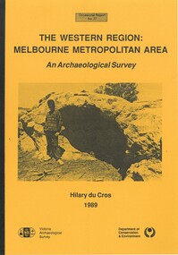 Bacchus Marsh & District Historical Society
Book, The Western Region: Melbourne Metropolitan Area: An Archaeological Survey
... The Western Region: Melbourne Metropolitan Area: An Archaeological Survey...AR/SU5 The Western Region: Melbourne Metropolitan Area: An Archaeological Survey Book HIlary Du Cros ...This study aimed to locate and document Aboriginal archaeological sites in the western region of Melbourne. This area was defined by the study as extending out from the western suburbs of Melbourne to the Brisbane Ranges and north beyond Bacchus Marsh. The specific aim of the study was to investigate the Aboriginal archaeology of the Western Plains area in the vicinity west of Melbourne. The Bacchus Marsh, Melton and Werribee shire boundaries of the time defined the areas of the study. The study contains extensive lists of the types of artifacts found the the locations where they were found.Soft cover foolscap size book. 96 pages with b & w illustrations, images and maps (some folded). Part of Occasional reports series (Victoria Archaeological Survey) ; No. 27. Published by Department of Conservation and Environment, Melbourne, 1990. Author, Hilary Du Cros. BMDHS Loc. AR/SU5This study aimed to locate and document Aboriginal archaeological sites in the western region of Melbourne. This area was defined by the study as extending out from the western suburbs of Melbourne to the Brisbane Ranges and north beyond Bacchus Marsh. The specific aim of the study was to investigate the Aboriginal archaeology of the Western Plains area in the vicinity west of Melbourne. The Bacchus Marsh, Melton and Werribee shire boundaries of the time defined the areas of the study. The study contains extensive lists of the types of artifacts found the the locations where they were found. aboriginal australians victoria western plains, aboriginal artifacts, archaelogical sites victoria western plains, aboriginal artifacts bacchus marsh region -
Beechworth RSL Sub-Branch
Equipment - Combat Ration One Man, January 2021
... Melourne, Greater Melbourne Area, Victoria, Australia ...Australian Defence Force - Combat Ration One Man used by members of the ADF on active duty in the field. In the collection they have a limited shelf lifeCombat Ration One ManCRIM Lot: 19.12.2018 / E (indicating menu E / Safety warning in Text box - CAUTION - FOOD ALLERGIES / This ration pack has NOT been constituted for consumers/ with any food allergy or special dietary requirements / Products used in ration packs may contain nuts, free nuts / cereals containing gluten, soy, fish, milk, egg crustaceans / sesame seeds and their products and/or added sulphites / Check the Ingredient List in the Information Sheet and or/product label before consumption. If you have any doubts / about the contents , you should not consume the ration pack. NOT FOR PRIVATE SALE TO PUBLIC -
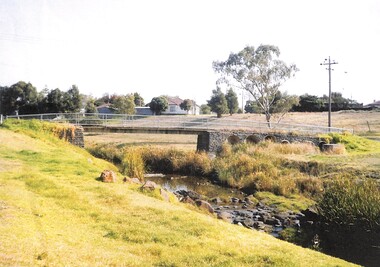
Port Melbourne Historical & Preservation Society
Map, City of Port Melbourne, Oct 1963
... Gives a visual understanding of the Port Melbourne area in 1963...A detailed map of the Port Melbourne area in October 1963. Details roads and laneways, undeground cables, light and power poles, sewer, bridges, piers reserve and park areas....Port Melbourne Historical & Preservation Society Port Melbourne Town Hall 333 Bay Street Port Melbourne melbourne Gives a visual understanding of the Port Melbourne area in 1963 local government built environment piers and wharves natural environment - beaches and foreshore parks and gardens piers and wharves - princes pier piers and wharves - station pier engineering - roads streets lanes and footpaths engineering - canals and drainage A detailed map of the Port Melbourne area in October 1963. ...Gives a visual understanding of the Port Melbourne area in 1963A detailed map of the Port Melbourne area in October 1963. Details roads and laneways, undeground cables, light and power poles, sewer, bridges, piers reserve and park areas.local government, built environment, piers and wharves, natural environment - beaches and foreshore, parks and gardens, piers and wharves - princes pier, piers and wharves - station pier, engineering - roads streets lanes and footpaths, engineering - canals and drainage -
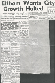 Eltham District Historical Society Inc
Document - Newspaper article, Diamond Valley News, Eltham Wants City Growth Halted, 31 Mar 1960
... ...Melbourne Metropolitan area...Eltham Council objects to unrestricted growth of Melbourne Metropolitan area...Eltham District Historical Society Inc 728 Main Rd Eltham melbourne Eltham Council objects to unrestricted growth of Melbourne Metropolitan area Eltham Housing development Melbourne Metropolitan area Urban Growth A3 photocopy Eltham Wants City Growth Halted Document Newspaper article Diamond Valley News ...Eltham Council objects to unrestricted growth of Melbourne Metropolitan areaeltham, housing development, melbourne metropolitan area, urban growth -
 Eltham District Historical Society Inc
Slide - Photograph, Eltham Shire Council, Hurstbridge area, Melbourne Metropolitan Planning Scheme, Amendment No. 21, Melbourne and Metropolitan Board of Works, Apr 1972
... Hurstbridge area, Melbourne Metropolitan Planning Scheme, Amendment No. 21, Melbourne and Metropolitan Board of Works...Eltham District Historical Society Inc 728 Main Rd Eltham melbourne Map Melbourne Metropolitan Board of Works MMBW Planning Proposals shire of eltham planning 35mm colour positive transparency blue Agfacolour Service plastic mount Hurstbridge area, Melbourne Metropolitan Planning Scheme, Amendment No. 21, Melbourne and Metropolitan Board of Works Slide Photograph Eltham Shire Council ...35mm colour positive transparency blue Agfacolour Service plastic mountmap, melbourne metropolitan board of works, mmbw, planning proposals, shire of eltham, planning -
 Sunshine and District Historical Society Incorporated
Photograph - Footbridge over Kororoit Creek Yallourn Street to Ballarat Road Ardeer, Johnson, Des, 7 Nov., 1988
... Melbourne Metropolitan Area / Ardeer, Victoria, Australia ...Donated to S&DHS1 to 6 This square blue stone foot bidge was originated by Norm stores of Derrimut Street Albion who was a Road engineer for Sunshine City Council between Yallourn Street and Sun Hill Crescent and Ballarat Road Ardeer C 1953 to 1954 Melway Map 26 B9kororoit creek, ardeer, bridge -
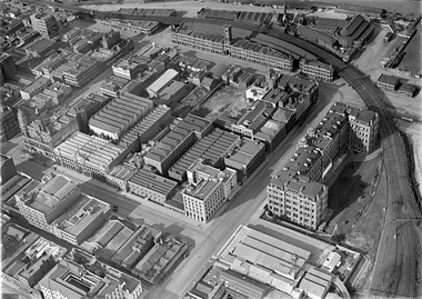 Sunshine and District Historical Society Incorporated
Photograph - Kevin and Jill O'Reilly Photograph Collection, Pratt, Charles, 1922 - 1928
... Melbourne Metropolitan Area, Victoria ,, Australia ...Photograph 1 and 2 by Charles Pratt approximately mid 1924 to 1930 showing Sunshine Harvester Works and surrounding building CD disk by Brian OReilly on 3 July 2012 17 mini photographs Photo 1 Brunswick Oval North Fitzroy Photo 2 City 6 Photo 3 Collingwood Photo 4 Deer Park Ammunition Photo 5 Download 267 Deer Park Photo 6 download 268 Deer Park Photo 7 download 269 Deer Park Photo 8 download 270 Deer Park Photo 9 download 272 Deer Park Photo10 download 276 Nettlefolds Sunshine Photo 11 Creamoata Factory Footscray West Photo 12 Mitchells Sunshine and Geelong Roads Photo 13 Footscray Photo 14 Maribyrnong Photo 15 Maribyrnong Munitions Photo 16 Newmarket Stock Yards Photo 17 Sunshine Photo 2 Hunt Club Deer Park Photo 3 Maribyrnong Munitions Photo 4 Corner Sunshine Road and Geelong Road Photo 5 South Kensington Photo 6 Melbourne City Corner Flinders Street and Spencer Street and Corner Collins and Spencer Street Photo 7 Creamota Mills Sunshine Road West Footscray Photo 8 Fitzroy Football Ground Brunswick Street Photo 9 Collingwood Football Ground Victoria Park Photo 10 Footscray Football Ground Photo 11 Newmarket Saleyards Photo 12 Leather cloth Fabrex Flay Kynoch Deer Park Photo 13 Nettleford and Spaldings Phoenix Firewords Photo 14 ICI Deer Park Photo 15 ICI Deer Park Photo 16 ICI Deer Park Photo 17 ICI Deer Park Photo 18 Sunshine Harvester Works HV McKay HV McKay had a building in Argentina called Agar of Argentina There is photographs of the building and a factory and a photograph of equipmenth.v. mckays, sunshine harvester works -
Koorie Heritage Trust
Book, Baluk Arts et al, Baluk Wurrung stories from the Aboriginal people in South East Melbourne, 2011
... ...Melbourne area....Koorie Heritage Trust Levels 1 & 3, Yarra Building Federation Square, Melbourne melbourne Life Histories -- Aboriginals Melbourne area. Life histories of Aboriginal people living in and near Melbourne. 103 P. photographs. ...Life histories of Aboriginal people living in and near Melbourne.103 P. photographs.Life histories of Aboriginal people living in and near Melbourne.life histories -- aboriginals, melbourne area.