Showing 452 items matching "melbourne school of land "
-
 University of Melbourne, Burnley Campus Archives
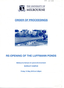
Programme, Melbourne School of Land and Environment et al, Re-Opening of the Luffmann Ponds, 14.05.2010
... ...melbourne school of land and environment...Guests included: The Hon Alex Cherney AO QC, Chancellor, John Fordham, President Friends of Burnley Gardens, Professor the Hon Barry Jones AO, Professor Rick Roush, Dean of Melbourne School of Land & Environment. Unveiling of Plaque....Melbourne School of Land and Environment...Re-Opening of the Luffmann Ponds Programme Melbourne School of Land and Environment The University of Melbourne Friends of Burnley Gardens ...Refurbishment of the Luffmann Ponds joint venture between the Friends of Burnley Gardens and The University of Melbourneluffmann ponds, refurbishment, ceremony, friends of burnley gardens, melbourne school of land and environment, alex cherney, barry jones, john fordham, plaque -
 University of Melbourne, Burnley Campus Archives
Magazine - Journal articles, Melbourne School of Land and Environment et al, Land & Environment, 2013
... The Melbourne School of Land and Environment Magazine, Winter 2013. ...Melbourne School of Land and Environment...University of Melbourne, Burnley Campus Archives 500 Yarra Boulevard Richmond melbourne green roofs sugar table The Melbourne School of Land and Environment Magazine, Winter 2013. ...green roofs, sugar table -
University of Melbourne, Burnley Campus Archives
Pamphlet - Symposium, Melbourne School of Land and Environment, Symposia on Contemporary Issues in Urban Landscapes, April 2013
... Melbourne School of Land and Environment...Symposia on Contemporary Issues in Urban Landscapes Pamphlet Symposium Melbourne School of Land and Environment ...horticulture, 150th celebrations, burnley gardens -
 University of Melbourne, Burnley Campus Archives
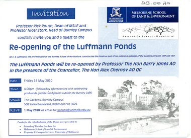
Card - Invitation, The University of Melbourne et al, Re-Opening of the Luffmann Ponds, 01.05.2010-14.05.2010
... ...Melbourne School of Land and Environment...Re-Opening of the Luffmann Ponds Card Invitation The University of Melbourne Melbourne School of Land and Environment Friends of Burnley Gardens ...luffmann ponds, refurbishment, rick roush, nigel stork, alex chernov, barry jones -
University of Melbourne, Burnley Campus Archives
Journal - Journal Extract, Melbourne School of Land and Environment, Land & Environment, Summer 2013
... Melbourne School of Land and Environment...University of Melbourne, Burnley Campus Archives 500 Yarra Boulevard Richmond melbourne 150th celebrations burnley gardens Article in Land & Environment Summer 2013 p 13. "Burnley Gardens 150th." Land & Environment Journal Journal Extract Melbourne School of Land and Environment ...150th celebrations, burnley gardens -
University of Melbourne, Burnley Campus Archives
Booklet - Prospectus, Graduate Prospectus, 2013
... melbourne...school of land and environment...University of Melbourne School of Land & Environment Graduate Prospectus. 39 pp....University of Melbourne, Burnley Campus Archives 500 Yarra Boulevard Richmond melbourne university of melbourne school of land and environment graduates University of Melbourne School of Land & Environment Graduate Prospectus. 39 pp. ...University of Melbourne School of Land & Environment Graduate Prospectus. 39 pp.university of melbourne, school of land and environment, graduates -
University of Melbourne, Burnley Campus Archives
Booklet, School of Land and Environment, Melbourne School of Land and Environment Postgraduate Conference 2008, 2008
... Melbourne School of Land and Environment Postgraduate Conference 2008...Conference held at Dookie Campus. Melbourne School of Land and Environment Postgraduate Conference 2008 Booklet Found in the Cottage, former residence of Poultry Curator in 2019 School of Land and Environment ...postgraduates, conference -
University of Melbourne, Burnley Campus Archives
Plan, Burnley Campus Melbourne School of Land & Environment
... Burnley Campus Melbourne School of Land & Environment...Burnley Campus Melbourne School of Land & Environment Plan ...site plan -
University of Melbourne, Burnley Campus Archives
Document - Prospectus, School of Land and Environment, Graduate Prospectus, 2011
... Produced by the Melbourne School of Land and Environment, The University of Melbourne...University of Melbourne, Burnley Campus Archives 500 Yarra Boulevard Richmond melbourne courses graduates Produced by the Melbourne School of Land and Environment, The University of Melbourne Graduate Prospectus Document Prospectus Found in the Cottage, former residence of Poultry Curator in 2019 School of Land and Environment ...courses, graduates -
University of Melbourne, Burnley Campus Archives
Booklet (Item), The University of Melbourne, The University of Melbourne Conferring of Degrees; One Hundred and Forty-Fifth Commencement (2000); One Hundred and Fifty-first Commencement (2006). 2 other booklets for 2010 ceremonies at Wilson Hall, and at Burnley Campus, 29.03.2000-22.04.2006 - Feb. & May 2010
... ...Melbourne School of Land & Environment...University of Melbourne graduation ceremonies undergraduate degrees postgraduate degrees Burnley campus Melbourne School of Land & Environment 4 Booklets: 2000 - 24 pp; 2006 - 41 pp. ...university of melbourne, graduation ceremonies, undergraduate degrees, postgraduate degrees, burnley campus, melbourne school of land & environment -
University of Melbourne, Burnley Campus Archives
Administrative record, School of Land and Environment, Conferring of Degrees, 2009
... Order of Proceedings, Melbourne School of Land & Environment Burnley Campus and Creswick Campus at Burnley Campus 15.05.2009...University of Melbourne, Burnley Campus Archives 500 Yarra Boulevard Richmond melbourne graduation burnley campus creswick campus Order of Proceedings, Melbourne School of Land & Environment Burnley Campus and Creswick Campus at Burnley Campus 15.05.2009 Conferring of Degrees Administrative record Found in the Cottage, former residence of Poultry Curator in 2019 School of Land and Environment ...graduation, burnley campus, creswick campus -
University of Melbourne, Burnley Campus Archives
Magazine - Journal articles, Land & Environment, 2010
... The Melbourne School of Land and Environment Newsletter Spring 2010. ...University of Melbourne, Burnley Campus Archives 500 Yarra Boulevard Richmond melbourne cas mclean green roofs nerissa hannink luffman ponds luffmann ponds The Melbourne School of Land and Environment Newsletter Spring 2010. ...cas mclean, green roofs, nerissa hannink, luffman ponds, luffmann ponds -
University of Melbourne, Burnley Campus Archives
Booklet, The University of Melbourne, Dean's Honours and Awards Presentation, 2002-2009
... melbourne...institute of land and food resources...school...The University of Melbourne Institute of Land and Food Resources 2002 Dean's Honours and Awards Presentation, Thursday 8 May, 2003. 2. The University of Melbourne School...The University of Melbourne Institute of Land and Food Resources 2002 Dean's Honours and Awards Presentation, Thursday 8 May, 2003. 2. The University of Melbourne School ...dean's awards, awards, the university of melbourne, institute of land and food resources, school of land and environment -
 University of Melbourne, Burnley Campus Archives
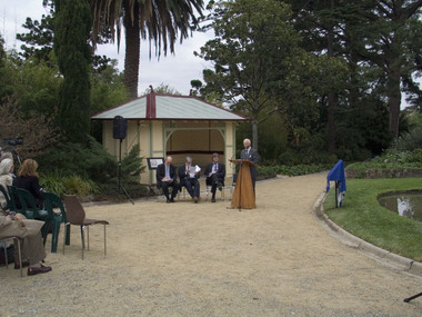
Album - CD, Sandra Pullman, Luffmann Ponds Opening 2010, 15 May 2010
... Key persons: Andrew Smith, Gardens Manager, Alex Chernov, Chancellor, The University of Melbourne, Prof Richard Roush, Dean Melbourne School of Land and Environment, Barry Jones, (former MP), John Fordham, Chairman Friends of Burnley Gardens...Key persons: Andrew Smith, Gardens Manager, Alex Chernov, Chancellor, The University of Melbourne, Prof Richard Roush, Dean Melbourne School of Land and Environment, Barry Jones, (former MP), John Fordham, Chairman Friends of Burnley Gardens opening luffmann ponds plaque friends of burnley gardens the university of melbourne sandra pullman fobg andrew smith alex chernov richard roush barry jones john fordham unveiling plaque lily ponds 14 colour slides on a CD. ...Created by Sandi Pullman on 15 May 2010. The opening of the Luffmann Ponds after they had been repaired with a concrete lining and reshaped. Unveiling of Plaque with picture and description of the ponds. Funded jointly by the Friends of Burnley Gardens and The University of Melbourne. Key persons: Andrew Smith, Gardens Manager, Alex Chernov, Chancellor, The University of Melbourne, Prof Richard Roush, Dean Melbourne School of Land and Environment, Barry Jones, (former MP), John Fordham, Chairman Friends of Burnley Gardens14 colour slides on a CD. The Opening of the Luffmann Ponds in 2010 after they had been repaired with a concrete lining and re-shaped. Unveiling of Plaque with picture and description of the ponds.opening, luffmann ponds, plaque, friends of burnley gardens, the university of melbourne, sandra pullman, fobg, andrew smith, alex chernov, richard roush, barry jones, john fordham, unveiling plaque, lily ponds -
 Warrnambool and District Historical Society Inc.
Original Document, Map: Agricultural area of Ballangeich 1865, 1865
... schools and a church.Tri weekly coaches ran to Colac, Warrnambool and Camperdown providing access to supplies mail and communication. This map is typical of many which were produced in the 1860's in Victoria during a significant period of Victoria's and Warrnambool district history. history of warrnambool ballangeich Land surveys Victoria 1865 Lands Act 1865 Victoria Ballangeich map 1865 At the top: Plan of the Agricultural area of Ballangeich 1865 At the bottom left: Prepared by the Board of Lands & Works in accordance with the Amending Land Act 1865 Lands & Survey Office Melbourne 13th April 1865. ...George Eddington arrived in Australia in 1839 and named and established property in 1841 calling the property Ballangeich after a Pass near his home town of Stirling in Scotland. It is situated 151 miles west of Melbourne and to the south of Mortlake and was originally part of the Mortlake shire, which was proclaimed 26th Jan 1864. Nearest streams are the Hopkins Riverand Lyall and Drysdale creek running through good agricultural land. This map relates to the breaking up of large runs which the Victorian government enabled through selection acts of the 1860's. The previously larger runs which were mainly cattle and sheep based were now more open to closer settlement and a greater variety in farming.The lots range in size from approximately 50 acres to around 600 acres.Some areas are set aside for reserves. By 1886 the population of Ballangeich had grown to around 600 with an hotel, three state schools and a church.Tri weekly coaches ran to Colac, Warrnambool and Camperdown providing access to supplies mail and communication. This map is typical of many which were produced in the 1860's in Victoria during a significant period of Victoria's and Warrnambool district history.Rectangular light card paper with black text showing allotments of land The area is coloured in green with scale at bottom right cornerAt the top: Plan of the Agricultural area of Ballangeich 1865 At the bottom left: Prepared by the Board of Lands & Works in accordance with the Amending Land Act 1865 Lands & Survey Office Melbourne 13th April 1865. With signaturehistory of warrnambool, ballangeich, land surveys victoria 1865, lands act 1865 victoria, ballangeich map 1865 -
 Warrnambool and District Historical Society Inc.
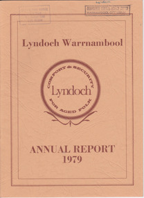
Document - Lyndoch Warrnambool 1979 Annual Report, 1979
... The original Lyndoch property near the mouth of the river Hopkins was owned by a Melbourne tea merchant, George Rolfe, who bought the land when there were only on the site a couple of cottages and a larger building which had been a school, Warrnambool Grammar, run by Henry Kemmis. ...The original Lyndoch property near the mouth of the river Hopkins was owned by a Melbourne tea merchant, George Rolfe, who bought the land when there were only on the site a couple of cottages and a larger building which had been a school, Warrnambool Grammar, run by Henry Kemmis. ...This is the 1979 Annual Report for Lyndoch Home and Hospital for the Aged, Warrnambool. It contains lists of Board Members, a President’s Report, a sketch of a proposed new building, financial reports, photographs and a list of Life Governors. Lyndoch Home for the Aged was established in 1952 and has developed with a wide range of facilities for the aged since that date. The original Lyndoch property near the mouth of the river Hopkins was owned by a Melbourne tea merchant, George Rolfe, who bought the land when there were only on the site a couple of cottages and a larger building which had been a school, Warrnambool Grammar, run by Henry Kemmis. Rolfe acquired the land in the 1870s and named the property Lyndoch after the town in the Barossa Valley where he had lived. He owned Lyndoch for 44 years and it was his stepdaughter, Florence Lake who built in the 1920s the bungalow known as Lyndoch which forms the original building of the Lyndoch Home for the Aged. Today the facility is called Lyndoch Living.This report is kept for the benefit of researchers wanting details of the history of Lyndoch over the past thirty or forty years.This is a booklet with a cardboard buff-coloured cover. There are six double-sided pages with printed material on white paper with a yellow and orange stripe across the top of the pages.On front cover: Lyndoch Warrnambool, Annual Report 1979 In brown circle on front cover: Lyndoch, Comfort and Security for Aged Folk Two library stamps on front cover (Warrnambool Library) lyndoch, aged care facility, warrnambool, hopkins, warrnambool grammar -
 Warrnambool and District Historical Society Inc.
Document - Lyndoch Warrnambool 1982 Annual Report
... The original Lyndoch property near the mouth of the Hopkins River was owned by a Melbourne tea merchant, George Rolfe, who bought the land when there were on the site only a couple of cottages and a larger building which had been a school, Warrnambool Grammar, run by Henry Kemmis. ...The original Lyndoch property near the mouth of the Hopkins River was owned by a Melbourne tea merchant, George Rolfe, who bought the land when there were on the site only a couple of cottages and a larger building which had been a school, Warrnambool Grammar, run by Henry Kemmis. ...This is the 1982 Annual Report for Lyndoch Home and Hospital for the Aged, Warrnambool. It contains lists of Board Members, a President’s Report, Lyndoch’s Aims, financial reports, photographs and a list of Life Governors. Lyndoch Home for the Aged was established in 1952 and has developed with a wide range of facilities for the aged since that date. The original Lyndoch property near the mouth of the Hopkins River was owned by a Melbourne tea merchant, George Rolfe, who bought the land when there were on the site only a couple of cottages and a larger building which had been a school, Warrnambool Grammar, run by Henry Kemmis. Rolfe acquired the land in the 1870s and named the property Lyndoch after the town in the Barossa Valley where he had lived. He owned Lyndoch for 44 years and it was his stepdaughter, Florence Lake who built in the 1920s the bungalow known as Lyndoch which forms the original building of the Lyndoch Home for the Aged, Today the facility is called Lyndoch Living. This 1982 report is kept for the benefit of researchers wanting details of the history of Lyndoch over the past 30 or 40 years. This is a booklet with a plasticized cover with a white back and a multi-coloured front cover. The front cover has a photograph of a Lyndoch building. There are six double-sided pages with printed material and photographs on white paper and a yellow and orange strip across the top of the pages. The pages are stapled.On front cover: Lyndoch Warrnambool Annual Report 1982 Stamp of Warrnambool Library On back cover: A red circle with the words ‘Lyndoch, Comfort and Security for Aged Folk’ lyndoch aged care facility, warrnambool, lyndoch warrnambool -
 Warrnambool and District Historical Society Inc.
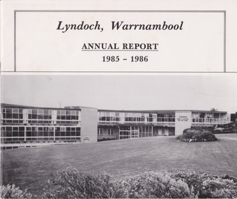
Document - Lyndoch Warrnambool Annual Report 1985-86, 1986
... The original Lyndoch property near the mouth of the River Hopkins was owned by a Melbourne tea merchant, George Rolfe, who bought the land when there were on the site only a couple of cottages and a larger building which had been a school, Warrnambool Grammar, run by Henry Kemmis. ...The original Lyndoch property near the mouth of the River Hopkins was owned by a Melbourne tea merchant, George Rolfe, who bought the land when there were on the site only a couple of cottages and a larger building which had been a school, Warrnambool Grammar, run by Henry Kemmis. ...This is the 1985-6 Annual Report for Lyndoch Home and Hospital for the Aged, Warrnambool. It contains lists of Board Members, a President’s Report, photographs, Lyndoch’s Aims, financial reports and a list of Life Governors. Lyndoch Home for the Aged was established in 1952 and has developed with a wide range of facilities for the aged since that date. The original Lyndoch property near the mouth of the River Hopkins was owned by a Melbourne tea merchant, George Rolfe, who bought the land when there were on the site only a couple of cottages and a larger building which had been a school, Warrnambool Grammar, run by Henry Kemmis. Rolfe acquired the land in the 1870s and named the property Lyndoch after the town in the Barossa Valley where he had lived. He owned Lyndoch for 44 years ad it was his stepdaughter Florence Lake who built in the 1920s the bungalow known as Lyndoch which forms the original building of Lyndoch Home for the Aged. Today the facility is called Lyndoch Living. This 1985-6 report is kept for the benefit of researchers wanting details of the history of Lyndoch over the past 30 or 40 years.This is a booklet with a plasticized white cover with a black and white photograph of a Lyndoch building on the front cover. There are eight double-sided pages with printed material and photographs. The pages are stapled.On front cover: ‘Lyndoch, Warrnambool, Annual Report, 1985-1986 On back cover: A black circle with the words: ‘Lyndoch, Comfort and Security for Aged Folk’. lyndoch aged care facility, warrnambool -
 Kiewa Valley Historical Society
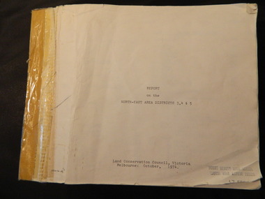
Report - Land Conservation Council x2, Land Conservation Council, Victoria Melbourne, April 1978, October 1974
... land kiewa valley planning Stamped on Front Cover: "Mount Beauty High School" Has a library borrowing slip at the back of the last page. Thick heavy book with 312 pages with black and white photos. Back half has a folder with heavy cardboard attached to thick cardboard back cover. Inside folder are 9 maps with color each with a different title. Land Conservation Council, Victoria Melbourne ...Land Conservation Act 1970 established the Land Conservation Council to investigate and recommend to the Minister use of public land in Victoria. It describes and assesses the natural resources:-Physiography, Geology, Topography, Land Systems, Outdoor Recreation, Public land and blocks. Primary Production. Vegetation.North East Victoria includes the Kiewa Valley. This report gives an understanding of the development of the area.Thick heavy book with 312 pages with black and white photos. Back half has a folder with heavy cardboard attached to thick cardboard back cover. Inside folder are 9 maps with color each with a different title.Stamped on Front Cover: "Mount Beauty High School" Has a library borrowing slip at the back of the last page.land conservation council, environment, public land, kiewa valley, planning -
 Kiewa Valley Historical Society
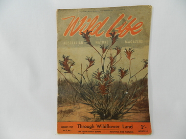
Magazine - Nature, Joseph Swanson Wilkinson, Wild Life Australian Nature Magazine, January 1949
... school. bogong. wild life. nature. 'Registered at G.P.O. Melbourne for transmission by post as a periodical'. written in black in tiny print across the top. 1st line: 'Wild Life' in orange with white outline. 2nd line: 'Australian Nature Magazine' in white underneath title. All across top. 3rd written line: 'January, 1949 Through Wildflower Land ...This magazine was part of the Bogong School's library and represents an important aspect of the school's curriculum.Bogong School was noted for having a great interest in nature and conservation. 48 page soft covered magazine. Cover with limited colour including orange, black, white and brown with green. Inside pages in black, brown and grey pictures with black print on off white pages. Page 41 is in cartoon form. 'Registered at G.P.O. Melbourne for transmission by post as a periodical'. written in black in tiny print across the top. 1st line: 'Wild Life' in orange with white outline. 2nd line: 'Australian Nature Magazine' in white underneath title. All across top. 3rd written line: 'January, 1949 Through Wildflower Land 1/-' underneath picture of Kangaroo Paw. in black Underneath this writing follows: 4th line: 'Vol.11 No. 1 The Truth About Borers : : Beautiful Bird Pictures' in black Underneath 1/- is 'Monthly' Background behind black writing is orange same as title.bogong primary school. bogong. wild life. nature. -
4th/19th Prince of Wales's Light Horse Regiment Unit History Room
Manual - Folder, loose leaf, Precis Holder Radio wing, c 1960
... 4th/19th Prince of Wales's Light Horse Regiment Unit History Room 4/19 PWLH Regiment, Building 78 Simpson Barracks Macleod melbourne Radio training of Regimental officers radio officer training 3 division Precis holder with badge of School of Land-Air Warfare Royal Australian Air Force Hard covered loose leaf folder containing the radio handouts from the 3 Division Officer Training School Wireless Wing and 4/19 PWLH Regt Radio Wing - from the 1960's Precis Holder Radio wing Manual Folder, loose leaf ...Radio training of Regimental officersHard covered loose leaf folder containing the radio handouts from the 3 Division Officer Training School Wireless Wing and 4/19 PWLH Regt Radio Wing - from the 1960'sPrecis holder with badge of School of Land-Air Warfare Royal Australian Air Forceradio, officer training, 3 division -
Federation University Historical Collection
Document, Zelda Martin, Central Victorian Goldmining towns - Boom Towns or Ghost Towns?, c1996
... Melbourne. Zelda Martin Victorian goldfield towns bendigo castlemaine ballarat Maldon Stawell Ararat maryborough Creswick Avoca Heathcote Banks Bank of Australasia Union bank of Australia government camp Sandhurst water supply Tarnagulla Talbot back creek Mountain Creek Police court Carisbrook dunolly thompson's foundry Charles Clacy Anthony Trollope Robert Cecil Mount Alexander urbanisation national schools education govenrment industry railway transport settlement land settlement in central Victoria Steiglitz Joseph Brady The New Australian Mine Berry Deep Leads William Guthrie Spence Creswick State Forest Arthur Worsley Worsley Cottage The Welcome Stranger Moliagul Moonambel Redbank St Arnaud Sebastapol Brown's Scarsdale Clunes Chewton Daylesford Bushfires Inkerman Inglewood Kingower Lintons Happy Valley Piggoreet McIvor Majorca Tarrangower Taradale The Coliban System The Syphon Sandy Creek Wedderburn Koorong Arnold Jones Creek Waanyarra The Golden Triangle Census 1857 Blackwood Buninyong Durham Lead Magpie Carngham Snake Valley Alma Amherst Daisy Hill Amphitheatre Mountain Hut Beaufort Fiery Creek Counties population gold fields commission of enquiry1854 William Westgarth Gold license Fee lieutenant Colonel Valiant administration of the victorian gold fields Commission to Enquire into Sludge 1859 E.S. ...Zelda Martin was a PhD candidate at the University of Melbourne.[.1] 4th item in light blue display book titled Research Approach/Overview of Chapters/Confirmation of Canditure/Chapters1,2,3&4 of proposed thesis. *Twenty-seven page article on Victorian goldfields towns titled: Central Victorian Goldmining Towns - Boom Towns or Ghost Towns. The article was written during the author's PhD study. It outlines the context methodology, and resources and the chapters of the proposed thesis: (1) Central Victorian Goldmining Towns - The Context (2) Contemporary Views of the Factors Necessary for Town Growth (3) Outward Manifestations of Town Growth (4) The Trappings of Government (5-9) The Main Towns and Their Hinterland. [.2] 5th item in Light Blue display book as above item. *Chapter 1 of proposed thesis titled 'Pick, Shovel and Tin Dish Mining.' Covers in Section A: Central Victoria - Pre 1851: Aborigines in Central Victoria, Squatters, and Government. Section B: The years 1851-1854: The Early Gold Rushes, Government Reaction, Township Surveys, Legislation, Town Development, Local Government and Early Settlement. [.3] 6th item in Light Blue display book as above item. *2A of proposed thesis titled 'Contemporary Views of the Factors Necessary for Town Growth'. Similar information to Chapter 1 plus extra re towns and maps. Sections: Introduction, Context of Place - Geographical Towns Listed, The Context of Time - Pre1851 Aborigines, Governance of Port Phillip, The Squatters, The Villages of Central Victorian Highlands, Conclusion, Condensed Version of Chapter2B. [.4] 7th item in Light Blue display book as above item. *Chapter2B of proposed thesis. Sections: Area of Research, Schools, Banks, Newspapers, Progress Association, Town Development - Sandhurst (Bendigo), Ballarat, Castlemaine,, Maryborough, Ararat and Stawell. [.5] 8th item in Light Blue display book as above item. *Chapter 3 of proposed thesis titled 'Outward Manifestations of Town Growth'. Sections: Introduction, Contemporary Writing, Educationalists, The Bankers, The Townsfolk, Current Theory, General Theories of Urban Development, and Conclusion. [.6] 9th item in Light Blue display book as above item. *Chapter 4 of proposed thesis titled 'Trappings of Government' Sections: Introduction, Early Government Attitudes to Mining and Town Development, Law and Order, Township Surveys, Legislation, Local Government, Transport and Communication, The People and Lobbyists. [.7] 10th item in Light Blue display book as above item. *'The Rise and Fall of Central Victorian Goldmining Towns'. Includes a map showing main Goldfields, a table showing towns and villages at two points in time - 1857 and 1871; a Bibliography of Primary and Secondary Sources. [.8] Resource No1. Black display book titled Local Towns 1 : Alma: *Brief history *Directory *Maps Amphitheatre / Mountain Hut: *Brief History Post Office Directory Ararat: *Brief History *Post Office Directory 1869 - Alphabetical Listing by Occupation *Ararat - Prominent Citizens of 1858 *Langi-Morgala Museum Avoca: *Brief History *Excerpts from 'Avoca The Early Years', Margery and Betty Beavis; pg1 - Beginnings; pg11 - The Midas Touch; pg25 - Local Gold Escorts; pg27 - A Town is Born; pg51- The Administration of Justice; pg53 - The Ways of the Law; pg61 - News of the Day; pg65 - A Time to Play; pg72 - Land Ownership *Post Office Directory (Bailliere's) 1869 *Tourism Map and Information of area *Historic Avoca - A 5.5km Tour *Avoca & the Pyrenees Region - information pamphlet Ballarat: *Early History of Ballarat - Ballarat Historical Society, Publication No.1: origin of the name; Ballaarat - the Beginning; Fabulous Yields from the Ballaarat Goldfield; *Streetscape Lydiard Street. *Hand drawn map showing Leigh River, Old Portland Bay Road, plaque on road to Colac; etc. *Newspaper article re 'The Theatre Royal' ( which stood in the vicinity of the current Owen Williams store) - 'The News'15/04/1998 *Article - 'Ballarat's Mechanics' Institute Lives On' Ballarat Courier, 14/09/1985 *Article - Standing the Test of Time' The News 17/11/1993 re The Mechanics Institute & picture of the Reading Room *'Ballarat a Study of a City, Phyllis Reichl, pub. Nelson, 1968; no.3 place, time and people field studies series *Investigator Vol.33 No.2, 1998 Geelong Historical Society. Article on pg75 describes Ballarat in 1861 *Folded poster - 'Ballarat 100' a history of telegraph communication, pub. Telecom. Beaufort (Fiery Creek): *Brief history *Post Office Directory [.9] Resource No.2 Black Folder Titled Towns cont.No2 Bendigo (Sandhurst): *'Family & Local History at the Bendigo Library - 1851-2001 150 years of gold'. *Bendigo Government Camp in 1853 illustration; key to sketch and names of Government officers stationed there *Excerpts from 'Bendigo and Vicinity' Adolph Haman *The Bendigo Goldfield Registry - pgs 1-7 Introduction *Excerpt: 'Breaking the Grip' *Excerpt: The Most Go-Ahead Place *Excerpts from 'History of Bendigo' - anti license agitation; laying out of town; proposed railway; gold calls and dividends; the Sandhurst Municipality; journalism *Bibliography Blackwood: *Excerpts from 'Aspects of Early Blackwood - The Goldfield, the Landmarks, the Pioneers' Alan J Buckingham and Margaret F Hitchcock, JG Publishing,1980 Buninyong: *A Brief History *Investigator Vol1 No.2 Feb 1966 Geelong Historical Society. Pg3 - Article re gold escort route - Mt Alexander to Adelaide - (see a simple monument on the Western Highway a few miles out of Horsham. Pg 15 - Ballarat Excursion - re the finding of gold. *Three articles published by Buninyong and District Historical Society Inc: (Magpie Exploration; Finding Gold In The Green Hills; Magpie Exploration; Burnt Bridge to Cargarie to Mt Mercer) *Copies of newspaper articles/items *Buninyong Street Directory Carisbrook: *In the Beginning There Was Carisbrook *The History of the Carisbrook Racecourse Carngham / Snake Valley: *Brief History *Directory Castlemaine: *Directory 1865-1866 - Alphabetical and Street *Poster - Castlemaine A Contemporary Guide "The Great Centre" 1866 - A Contemporary Guide to the Fascinating Past *Pamphlet - Castlemaine District Community Hospital *Map - Castlemaine, Maldon & Surrounding Districts *Map and Information - The Dry Diggings Track - a 55kl walk among historic goldfields relics ( Castlemaine Fryerstown Vaughan Mt Franklin Hepburn Daylesford) *Postcard - Former Court House *Directory 1867 - Alphabetical, Trade [.10] Resource No.3 Grey folder Titled Towns 3 Creswick to Maryborough Creswick: *Brief History *Booklet - "Creswick Cemetery Walk" *Booklet - The Buried Rivers of Gold Heritage Trail Creswick *Creswick Historical Museum Information Sheet *Chronological History of Creswick *Alphabetical Directory of the Borough of Creswick *Creswick's Creek Directory 1856 *Historic Creswick Walking Tour *A Brief Account of the Schools of Creswick - Past and Present *100 Years of Railway Travel in Creswick *The Berry Deep Leads *The Spence Home at Jackass Gully in the Creswick State Forest ( William Guthrie Spence - Pioneer) *The New Australian Mine and the 1882 Disaster *Creswick District News, Issue 7, July August 1999 *The Creswick Miners Walk - Information and Map *Maps Chewton: *Brief History *Directory Clunes: *Brief History *Clunes Street Directory Daylesford: *Brief History *Notable Bushfires in Daylesford District Over More Than a Century - "Black Thursday" 1851; 1862; 1899; the Disastrous Hepburn Fire of 1906; 1939; 1944; 1969. *Post Office Directory -Daylesford and Hepburn Dunolly / Inkerman: *Brief History *Directory *Pamphlet - Goldfields Historical Museum *Pamphlet - Historic Dunolly - Victoria's Best Kept Secret *Map of Gold Workings at Dunolly Area - showing where the main gold rushes occurred *Brief History - Inglewood *Directory - Inglewood - Name Occupation, Dwelling Kingower: *Brief History *Directory - Name / Ocupation / Dwelling Linton / Happy Valley / Piggoreet: *Brief History *Directory - Lintons McIvor: *"A History of the Shire and the Township of Heathcote" by J.O. Randell Majorca: *Brief History *Official Post Office Directory 1869 - Name / Occupation/ Address Maldon (Tarrangower): *Brief History Part 1 *Brief History Part 2 *Post Office Directory *List - Alphabetical Order by Names plus Business and Trade (Tarrangower Times Oct/1858) *List - Alphabetical Order by Trade plus Name and Business *Directory - Name / Occupation / Dwelling Maryborough: *Worsley Cottage - built by Arthur Worsley, a contractor in stonework in 1894 [.11] Resource No. 4 Blue Display Book titled Towns 4 Moliagul to Stawell Moliagul: *Brief History *Moligul Legislative Assembly (Voting?) List - Names and Occupations *Moliagul Victorian Post Office Directory 1868 - Name / Ocupation / Address / Comments *"The Welcome Stranger" gold nugget *The Sunday School *The Welcome Stranger Discovery Walk - information and map Moonambel (Mountain Creek) Redbank *Brief History *List of names extracted from advertisments of the Pioneer and Mountain Creek Advertiser 16/02/1861. *Bailliere's Directory 1869 - Alphabetical List of Name / Occupation / Place St Arnaud: *Brief History Sebastapol: *Brief History *Directory 1869 - Alphabetical by Name; plus occupation and address. Browns and Scarsdale: *Brief History *Browns Street Directory - Name and Occupation Smythesdale: *Brief Description *Smythesdale Street Directory -Name and Occupation Stawell (Pleasant Creek) *Brief History *Victorian Official Post Office Directory - Name /Occupation / Dwelling *Chronology - 1841-1920 *Production of gold statistics - 1879 - 1900 *Big Hill *Extracts from "The Golden Years of Stawell". Chapt 1 - Stawell's Coming Out. Capt. 2 - The Gold Rush. Caapt.3 - Cradle of Democracy. Chapt.4 - The Reefs Becomes Stawell. Chapt. 5 - Rushing In. Chapt.6 - The Pioneers. Chapt 7 - The Decade of Optimism. [.12] Resource No. 5: Blue Display Book titled 'Towns Steiglitz to the The Golden Triangle. Steiglitz: Brief History Victorian Post Office Directory 1869 *Map of Steiglitz *List of maps relevant to Steiglitz history *Information 6 tables of data from "Reports of Mining Surveyors Talbot (Back Creek) Brief History Taradale: Post office Directory 1869 - Name/Occupation/Street. Also list in alphabetical order by Occupation Taradale *Chronological Reference to Taradale Mines *Water - The Coliban System of Waterworks *Joseph Brady *The Syphon Tarnagulla (Sandy Creek) *Brief History *Tarnagulla Businessmen Cameos to give depth to advertisments in 'The Tarnagulla Courier' various issues 1864-1871 *Directory - Name/Occupation /Address *List - Name/Business/Trade Wedderburn (Koorong) *Brief History *List - Name/Occupation The Golden Triangle: *The Early Rushes - Wedderburn / Moliagul / Sandy Creek - Tarnagulla / Jones Creek - Waanyarra / Kingower / Dunolly - Goldsborough / Inglweood *Census of 1857 - Population / Occupations *1858-1871 - A Time of Consolidation- Wedderburn / Moliagul / Sandy Creek- Tarnagulla / Arnold *Census 1871 - Population *Information gleaned from the census data - Demographics / Population / Occupations / marital / Birthplace / Religion / Literacy/ Occupation and Housing Cameos *Graphs - Birthplace of settlers /Male-Female Ratio / Married males / Children under 15 as Percentage of Population / Religion *Census 1857 - Statistical data *Maps *Bibliography [.13] Resource No. 6 - Black Display Book Information and Research in Central Victoria including: *Banking - Research from ANZ Bank Archives *Institutions - also includes articles listed from the Ballarat Times Newspaper *Australian mining History Association - A.M.H.A. Bibliography *Australia's Mining History * Bibliography - Land Surveys Victoria - *1853 Administration (Statistics and Other) includes: schools / ministers of religion / police / military / local administration / licences for sale of spirits / distances between various Victorian gold fields. * Victoria Government Gazette (Copy) - N0. 116, 12/12/1854 includes: Gold Felds Commission of Enquiry & No. 85, 15/09/1854 - Addresses presented to the Lieutenant Governor (Sir Charles Hotham) during his tour through the Gold Fields of Victoria,1854. Addresses on behalf of : the people of Bendigo; Members of the Church of England, Bendigo; Members of the Wesleyan Church on the Bendigo Gold Fields; Bendigo Gold District General Hospital; the Bendigo Prospecting Association; Committee of the Bendigo Local Exhibition; Bendigo District Medical Association; Coloured Americans Resident at Bendigo; German Inhabitants of Bendigo; Landowners, Inhabitants, and Miners of Castlemaine; Inhabitants of Forest Creek; Inhabitants of Heathcote and Gold Miners of McIvor; Residents and landholders of the District of Bacchus Marsh; Inhabitants of Kilmore and Vicinity. *Gold Fields Correspondence 1853: letter from Lieutenant Colonel Valiant, (Officer commanding the Troops in Victoria) to the Lieutenant Governor re threatened disturbance at Sandhurst (Bendigo) regarding the Gold License Fee. * Extracts from a book "Victoria" re Gold Fields Commission of Enquiry involving mainly Ballarat and Castlemaine and a chapter titled 'A Tour to the Victorian Gold-Fields' *Lists of central Victorian newspapers - listed by date published 1851to 1874; by first date available to State Library. *A list of cities and towns showing County, population in 1861 &1871, and municipal status. [.14] Resource no.7. Black display book. *Reference: Papers presented to Parliament Victoria - 1859-1860 4 volumes - relevant sections copied. Contains information on Branches of Government. General / Finance / Gold / Gazette / Commission and Warrant / Statistic. *Gold Fields Act. In accordance with the Act the gold fields are divided into six districts - Ballaarat, Castlemaine , Sandhurst, Avoca, Ararat, and Beechworth.. Official staff in each gold district consists of a Resident Warden, Wardens, Wardens' Clerks, Bailiffs, Chinese Protectors, Chinese Interpreters, and Mining Surveyors. *Gold Receiver *Gaols *Police magistrates and Clerks of Petty Sessions, etc. *Field Branch *Immigration and Emigration Overland - Chinese - 1859 *Population on the Goldfields *The Geological Survey - The Government Geologist is assisited by staff from four branches - the office Branch; the Publishing Branch; the Field Branch and the Museum Branch. *Commission to Enquire Into Sludge dated 10/02/1859 (Some sections copied) - Report to the Honorable Chief Commissioner of Public Works, Melbourne re the mode of carrying the sludge from the puddling mills in Sandhurst without interfering with the drainage of the town and the roads in the neighbourhood. [.15] Resource No.8: Camel display book titled Resource No. 8. Aborigines *Lists of book titles - +"Readings in Victorian prehistory" +"The Aborigines of Port Phillip" +Aboriginal languages and clans" +"A History of the Port Phillip District" +"Langi Ghiran 1: Aboriginal Rock...." +"Koorie History: sources for aboriginal studies in the State Library of Victoria", ed. Tom Griffiths, Melb. Friends of the State Library, 1989 +"The Public Lands of Australia Felix"; settlement and land appraisal in Victoria1834-91 with special reference to the Western Plains", J.M.Powell, Melb. Oxford University Press 1970 +*Bibliography of the Victorian Aborigines' from the earliest manuscripts to 31st December 1970, Massoa, Aldo, Melb. Hawthorn Press, 1971 +"Aborigines in Colonial Victoria, 1836-1886", M.F. Christie, Sydney University Press, 1979 +"Urban and Industrial Australia: readings in Human Geography" ed J.M. Powell, Melb. Sorrett Pub. 1974 *Extracts: -Processes of Pioneer Settlement - The Squatting Occupation of Victoria, 1834-60. J.M. Powell -Areal Variations in the Class Structure of the Central-Place Hierarchy. P. Scott - Volume1 and Volume 2: Notes Relating to the Habits of the Natives of Other Parts of Australia and Tasmania. Compiled from various sources for the Government of Victoria by R Brough Smyth. John Curry, O'Neil, Melb. 1st pub. Melb. 1876. p31-45 - Numbers and Distribution of the Aborigines in Victoria -Victorian Aborigines 1835-1901 - A Resource Guide to the Holdings of the Public Record Office, Victoria; published by the Government Information Centre 1984. *History of the Aboriginal Artefacts Displayed in the Daylesford Museum. F. G. Powell (4 page pamphlet) *Letter to Zelda Martin from Peter Lovett, Cultural Officer, Ballarat & District Aboriginal Co- Operative, 05/02/1997 *Map: Ian Clarke Victorian Tribunal Boundary Map - Clans of Central Victoria. *Victorian Rock Art and Mythology - Article about Mount Langhi Ghiran and myths of the Tjapwarong people. *Two Aboriginal myths relating to the Grampians - 'The Monster Emu' / 'The Aquisition of Fire', by the Aborigines in the Grampians Areas *Article titled (chapter 8) Ballarat - information re camping sites in the region. Lake Wendouree / Lake Burrumbeet (includes a myth) / Mt Bunninyong / Lal Lal / Pitfield / Mount Elephant / Mount Egerton / Meredith / Lake Goldsmith / Lake Learmonth / Ercildoune *Notes on the Aborigines of the Wider Ballarat Region plus European names=Aboriginal names. John Morris 26/07/1995 *Role of Aborigines in Town Development in Central Victoria. Mentions Native Police Force est. in Port Phillip 1842 and Central Board for Aborigines est. 1860 *The Grave of King Billy. (Frank Wilson) Pamphlet. *Camping Places in Central and Northern Victoria. Article re Lake Burrumbeet site. *Programme for the Unveiling of Memorial Cairn for Edward Stone Parker 1802-1865. Note portrait not accurate. Accurate portrait is available in the book "A Successful Failure A Trilogy The Aborigines and Early Settlers", Edgar Morrison, Graffiti Publications, 2002. * Large envelope addressed to Mr G Netherway containing newspaper cuttings regarding the life of Edward Stone Parker, the unveiling of the Memorial Cairn as mentioned above, articles titled 'Episodes from Our Early Days' (Edgar Morrison, Yandoit)- The Black's School, A School At Last and The Final years. Also a typed page titled 'Historical Background to E.S.Parker's Career. Includes an interesting tale titled 'When the cat lay doggo' re laying power leads for the unveiling ceremony at the memorial site. [.16] green display folder titled 'Research Aids' *List of references to Commissioners' & W'ardens' Reports (formerly held at La Trobe Library Archives, now at Public Records Office [PRO]). Indicates town referred to / date of report / name of camp if different to town. * Archive information re Anglican Records *Movement around the Goldfields - Miners and Storekeepers - usefulness of newspapers in providing information - areas covered - Castlemaine, Maldon, Ararat, Stawell, Tarnagulla, Dunolly. *Port Phillip /Victoria Directories 1839/1867 - Chronological list of Directories included in this series. *"Notes on the History of Local Government in Victoria" A.W. Greig Melb. University Press 1925 - Photo-copied extract p5-p40. (Source - Deakin University Library) - Introduction by W.Harrison Moore. Section 1 - Development in New South Wales Before Separation. Section 2 - Development in Victoria After Its Separation from New South Wales. Hand written notations: 'roads, markets, and local government 1855 on' ;'opportunity of squatters in parliament' and 'opportunities of matters in parliament p33' * Notes on the Establishment of Surveyor General's Department 1851and Commissioner of Crown Lands and Survey. * Newspaper articles from The Argus, 1849, re the discovery of gold in the Pyrenees region. * Excerpt - a report on schools - A.B.Orlebar, Inspector; re the need for permanent school buildings rather than tents. *Excerpt from - 'Approaches to Urban History', Sean Glynn: The Case for Caution * Except from - 'The Urban Sprinkle', Weston Bate: Country Towns and Australian Regional History *Reference- 'The History of Land Tenure in the Colony of Victoria', John Quick. References the Haines Land Bill, land tenure and Land Leagues. [.17] Light blue envelope folder titled 'Birtchnell's Ballarat, etc. Directory 1862 *Contains various directories for Smythesdale, Buninyong, Clunes, Brown's and Creswick. [.18] Red envelope folder no.2 titled Victorian Gazetteer *Selected pages from 1869 Victorian Gazetteer on A4 paper (with a handwritten note questioning if some pages are from 1868 Victorian Gazetteer as appears to be different sizes - A3 pages.) Information includes locations and descriptions of towns, hotels, banks, communications and populations. (Does not include names, residences and occupations) [.19] Red Envelope folder titled Bailliere's Official Post Office Directory 1868 (or1869 or a mixture of both?) *Preface *Contains a selection of pages of towns highlighted in yellow in the the index *Work on this directory was commenced in 1867. *Information includes: Municipalities - mayors and councilors; lists of towns naming male inhabitants and their occupations. [.20]Yellow manila folder titled Post Grad Seminar Presentation 1996 *Gives some background to Zelda Martin's proposed thesis and why she chose the topic Gold Mining Towns Boom or Bust [.21] A3 display book - No. 1A * A list of 'Relevant Newspapers collected: The Tarrangower Times and Maldon Advertiser (first published 1858) Includes dates 1858-1867. The Mount Alexander Mail. Includes dates 1854-1866 The Tarnagulla Courier. Includes dates from1864-1871 Dunolly and Burnt Creek Express. Includes dates from 1862-1871 * Selection of newspaper pages from The Mount Alexander Mail 1854 to 1856, mostly showing advertisements for businesses and services provided to that community. [.22] A3 display book - No. 1B * Selection of newspaper pages from The Mount Alexander Mail 1857 to 1866, mostly showing advertisements for businesses and services provided to that community. [.23] A3 display book -No. 2 * Selection of newspaper pages from The Tarnagulla Courier 1864 to 1871, mostly showing advertisements for businesses and services provided to that community. [.24] A3 display book - No. 3 *Selection of newspaper pages from The Tarrangower Times (and Maldon and Newstead) Advertiser 1858 to1867, mostly showing advertisements for businesses and services provided to that community. [.25] A3 display book - No.4 * Selection of newspaper pages from The Dunolly and Burnt Creek Express; and The Dunolly and Betbetshire Express 1862 to 1871, mostly showing advertisements for businesses and services provided for that community. [.26] A3 display book - No.5 Includes: * Bryce Ross's Diggings Directory. Includes instructions for using this directory. This directory was used by "all persons having connexion or desiring to communicate with 'working parties, private friends, or Stores at the Diggings." As a directory for each area wwas completed it was published in each month's issue of Bonwick's "Digger's Magazine." Years c1852/1853. This Directory commences first at the head of Forest Creek. Includes a directory for Bendigo and Ballarat. Of interest at the end of the Bendigo and Ballarat directory is a list of the number of storekeepers, butchers, doctors, smiths, eating houses, lemonade sellers and chapels. * The Castlemaine Directory and Book of General Information Comprehending Glass's Model Calendar for the Two Years 1862 and1863. "zelda martin, victorian goldfield towns, bendigo, castlemaine, ballarat, maldon, stawell, ararat, maryborough, creswick, avoca, heathcote, banks, bank of australasia, union bank of australia, government camp, sandhurst, water supply, tarnagulla, talbot, back creek, mountain creek, police court, carisbrook, dunolly, thompson's foundry, charles clacy, anthony trollope, robert cecil, mount alexander, urbanisation, national schools, education, govenrment, industry, railway, transport, settlement, land settlement in central victoria, steiglitz, joseph brady, the new australian mine, berry deep leads, william guthrie spence, creswick state forest, arthur worsley, worsley cottage, the welcome stranger, moliagul, moonambel, redbank, st arnaud, sebastapol, brown's, scarsdale, clunes, chewton, daylesford, bushfires, inkerman, inglewood, kingower, lintons, happy valley, piggoreet, mcivor, majorca, tarrangower, taradale, the coliban system, the syphon, sandy creek, wedderburn, koorong, arnold, jones creek, waanyarra, the golden triangle, census 1857, blackwood, buninyong, durham lead, magpie, carngham, snake valley, alma, amherst, daisy hill, amphitheatre, mountain hut, beaufort, fiery creek, counties, population, gold fields commission of enquiry1854, william westgarth, gold license fee, lieutenant colonel valiant, administration of the victorian gold fields, commission to enquire into sludge 1859, e.s. parker, edward stone parker, edgar morrison, mount franklin protectorate, dja dja wurrung, memorial cairn, franklinford, mt franklin memorial cairn, jajowurrong, dja dja wurung, tjaowarong, wothowurong, assistant protectors, daylesford museum, buluk, rock art - grampians, aboriginal mythology - grampians, aborigines, first nations people, mount franklin, aboriginal artifacts, lake burrumbeet, native police force, central board of aborigines, yandoit, commissioners' reports, wardens' reports, port phillip/victoria directories 1839-1867, local government - victoria 1853/1854, surveyor general's department - 1850's, victorian schools 1850's, a.b.orlebar, haines land bill, william charles haines, wilson gray, land tenure, land leagues, victorian gazetteer, the tarrangower times and maldon advertiser - 1858-1867, the mount alexander mail 1854-1866, the tarnagulla courier 1864, dunolly and burnt creek express 1862-1871, bryce rose's diggings directory, the castlemaine directory 1862-1863 -
 Federation University Historical Collection
Photograph, John William Lindt, Miles Barraclough, Head teacher of Happy Valley School, c1884, c1884
... School opened under the name of Happy Valley in 1883, and the brick building probably dates from that time. Miles Barraclough was the head teacher from 1873 to 1887. When mining ceased the population declined and the land reverted to grazing. The School closed in 1940. (Visions and Realisations) happy valley happy valley school barraclough j.w. lindt miles barraclough miles barrowclough lucky woman's myles barraclough Happy Valley School Principal Verso Handwritten "Sept-84 Mr Barraclough School teacher Happy Valley" Printed "From J.W. Lindt Photographer Prize Medalist Philadelphia Paris Sydney Brisbane Sandhurst Melbourne ...Happy Valley was originally called Lucky Woman's. The School opened under the name of Happy Valley in 1883, and the brick building probably dates from that time. Miles Barraclough was the head teacher from 1873 to 1887. When mining ceased the population declined and the land reverted to grazing. The School closed in 1940. (Visions and Realisations)Sepia photo of Happy Valley School Teacher, Mr Miles BarracloughVerso Handwritten "Sept-84 Mr Barraclough School teacher Happy Valley" Printed "From J.W. Lindt Photographer Prize Medalist Philadelphia Paris Sydney Brisbane Sandhurst Melbourne 7 Collins Street East Melbourne.happy valley, happy valley school, barraclough, j.w. lindt, miles barraclough, miles barrowclough, lucky woman's, myles barraclough, happy valley school principal -
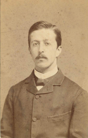
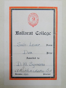 Ballarat Clarendon College
Book, The land that is desolate: an account of a tour in Palestine
... Melbourne University. He became a Clothing industry leader and was Fletcher Jones' distinguished successor as chief executive of the FJ organisation, and a prominent advocate for the Australian textile and clothing industries, decentralised industry and government support of employee share ownership schemes. donald-neil-symons dux 1930s fletcher jones Bookplate inside front cover: School crest / Ballarat College / Sixth-Lower Form / Dux Prize / Awarded to / D N Symons / A Richardson BA / December 1930 Principal Medium-sized, maroon, leather-bound book with gold-lettering and decoration on spine and gold school crest on front cover; bookplate inside front cover The land that is desolate: an account of a tour in Palestine Book ...Awarded to Donald Neil Symons for excellence in Scripture during 1926 at Ballarat College. Neil was educated at Ballarat College (Dux 1933) and Ormond College, Melbourne University. He became a Clothing industry leader and was Fletcher Jones' distinguished successor as chief executive of the FJ organisation, and a prominent advocate for the Australian textile and clothing industries, decentralised industry and government support of employee share ownership schemes.Medium-sized, maroon, leather-bound book with gold-lettering and decoration on spine and gold school crest on front cover; bookplate inside front coverBookplate inside front cover: School crest / Ballarat College / Sixth-Lower Form / Dux Prize / Awarded to / D N Symons / A Richardson BA / December 1930 Principaldonald-neil-symons, dux, 1930s, fletcher jones -
 Eltham District Historical Society Inc
Photograph, Antonio and Angelina Casonato and family
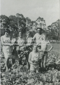
... Eltham District Historical Society Inc 728 Main Rd Eltham melbourne Antonio and Angelina Casonato with their four children and a baby cousin taken with lettuces growing on the river flat at Bell Street, Fabbro Farm (Fabbro Fields) in front of Eltham High School in the late 1960s. The site of the Fabbro farm (Diamond Creek side land ...Antonio and Angelina Casonato with their four children and a baby cousin taken with lettuces growing on the river flat at Bell Street, Fabbro Farm (Fabbro Fields) in front of Eltham High School in the late 1960s. The site of the Fabbro farm (Diamond Creek side land) is now made up of Fabbro Fileds and Barrack Bushlands. This title is fairly recent after the Shire of Eltham purchased the land, including the last section in 1993/94. About this time the area on the west side of Falkiner Street was purchased by a private developer and developed as housing. The area in Bell Street opposite the Eltham High School was purchased by the State Government is recent years and is called Fabbro Fields. The Fabbro Family operated their farm in Bell Street, Eltham. 1 black and white photograph reproduction print (low quality)fabbro's farm, bell street, eltham, farming, vegetables, angelina casonato, antonio casonato, fabbro family, fabbro farm, fabbro fields -
 Eltham District Historical Society Inc
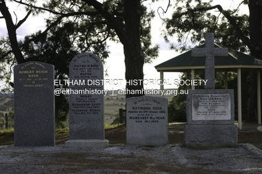
Photograph - Digital Photograph, Alan King, Reid family graves, Arthurs Creek Cemetery, 30 March 2008
... School No 945, before it was moved to its present site, stood on land to the south of Chapel Lane, which had been donated by Hazel Glen owner, William Reid. In May 1895 the post office was renamed Doreen to avoid confusion with the Reid’s address. The Arthurs Creek Cemetery was originally the private cemetery of Hazel Glen pioneers Agnes and Patrick Reid. The Reids with their eight children, arrived in Melbourne...melbourne The Arthurs Creek Cemetery was originally the private cemetery of pioneers Agnes and Patrick Reid. Published: Nillumbik Now and Then / Marguerite Marshall 2008; photographs Alan King with Marguerite Marshall.; p11 The Hazel Glen property, at Middle Hut Road, Arthurs Creek, which includes one of Victoria’s earliest pioneer buildings, was the forerunner to the Arthurs Creek and Doreen townships. At one time the Doreen Post Office and school were called Hazel Glen. The Hazel Glen State School No 945, before it was moved to its present site, stood on land ...The Arthurs Creek Cemetery was originally the private cemetery of pioneers Agnes and Patrick Reid. Published: Nillumbik Now and Then / Marguerite Marshall 2008; photographs Alan King with Marguerite Marshall.; p11 The Hazel Glen property, at Middle Hut Road, Arthurs Creek, which includes one of Victoria’s earliest pioneer buildings, was the forerunner to the Arthurs Creek and Doreen townships. At one time the Doreen Post Office and school were called Hazel Glen. The Hazel Glen State School No 945, before it was moved to its present site, stood on land to the south of Chapel Lane, which had been donated by Hazel Glen owner, William Reid. In May 1895 the post office was renamed Doreen to avoid confusion with the Reid’s address. The Arthurs Creek Cemetery was originally the private cemetery of Hazel Glen pioneers Agnes and Patrick Reid. The Reids with their eight children, arrived in Melbourne in April 1839. In 1844 Patrick Reid took over the licence to the Stewart Ponds run of 5120 acres (2072ha). Reid renamed it Hazel Glen, after Hazelden, the name of the Reid estate at Mearns in Renfrewshire, Scotland. Reid built a small cottage from local stone and hand-made bricks, with walls one yard (91 cm) thick, a flagstone floor and a shingle roof. Today two rooms and a store room survive as part of a larger house. Agnes died in 1847 aged 49, and was buried on a hill overlooking Hazel Glen, where it is said she had asked to be buried as it had been a favourite picnic spot.2 In 1858 Patrick died aged 74, and was buried near her. Their son William was to become Whittlesea Shire’s first president. From 1868 he was a Whittlesea Roads Board member, then a shire councillor until shortly before his death in 1923 aged 88. In 1865 the Reid’s burial area was no longer on their property, so it was declared a cemetery site. In 1867 it became the Linton Public Cemetery, being in the Linton Parish. However, to avoid confusion with Linton near Ballarat, the cemetery was renamed the Arthurs Creek Public Cemetery in 1926. Arthurs Creek was named after Henry Arthur, a pastoralist and public servant, who ran 1000 sheep lower down the Creek, from 1836 to 1841. It is believed he built his home at the end of today’s Challenger Street in Diamond Creek.This collection of almost 130 photos about places and people within the Shire of Nillumbik, an urban and rural municipality in Melbourne's north, contributes to an understanding of the history of the Shire. Published in 2008 immediately prior to the Black Saturday bushfires of February 7, 2009, it documents sites that were impacted, and in some cases destroyed by the fires. It includes photographs taken especially for the publication, creating a unique time capsule representing the Shire in the early 21st century. It remains the most recent comprehenesive publication devoted to the Shire's history connecting local residents to the past. agnes reid, arthurs creek cemetery, nillumbik now and then (marshall-king) collection, patrick reid, reid family -
 Eltham District Historical Society Inc
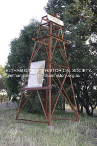
Photograph - Digital Photograph, Alan King, Golden King Mine poppet-head, Yarrambat Primary School, 1 February 2008
... melbourne The Golden King Mine poppet-head stands at the school’s Yan Yean Road exit gate. Published: Nillumbik Now and Then / Marguerite Marshall 2008; photographs Alan King with Marguerite Marshall.; p23 Early Yarambat - Tanck's Corner Its early settlers, who in the 1840s were amongst the first non-Aboriginal people in the area, found life tough as they grazed their sheep and cattle. Yarrambat was then known as Tanck’s Corner or Reynolds Corner, after wood carter, Frederick Tanck, who owned land ...The Golden King Mine poppet-head stands at the school’s Yan Yean Road exit gate. Published: Nillumbik Now and Then / Marguerite Marshall 2008; photographs Alan King with Marguerite Marshall.; p23 Early Yarambat - Tanck's Corner Its early settlers, who in the 1840s were amongst the first non-Aboriginal people in the area, found life tough as they grazed their sheep and cattle. Yarrambat was then known as Tanck’s Corner or Reynolds Corner, after wood carter, Frederick Tanck, who owned land north of Ironbark Road, at the corner of Yan Yean Road, and Thomas Reynolds, owner of the opposite property. After Reynolds sold his land, the corner became known as Tanck’s Corner. In 1929 the district’s name was changed to Yarrambat, believed to mean ‘high hill’ in the Wurundjeri language. Tanck’s Corner was in the centre of gold-bearing country and the district is honeycombed with old tunnels and shafts. However although gold played a dominant role for decades, there was insufficient to develop a substantial township. Meat and agricultural produce made a greater impact. Until the mid-20th century the only substantial building was the primary school. The first gold rush occurred around 1860, the second after 1900; then during the Depression, the Government paid men to pan for gold. The first rush attracted hundreds of Chinese people to Smugglers Gully, who constructed round diggings to keep away spirits. Alluvial miners lived along the Plenty River in tents or humpies - some fenced with gardens - and some miners distilled their own ‘plonk’. It was a wild time and bushrangers - and later gangster Squizzy Taylor - were said to hide4 in the old Pioneer Tunnel in Dunne’s Gully between Heard Avenue and Pioneer Road. Mines opposite Tanck’s Corner included Beer’s Line, Golden Crown and Golden Stairs. Some of the big mines had batteries and stampers to process quartz. At first there was plenty of alluvial gold, as much as two ounces to the ton. At times gold was exposed after heavy rains so fossickers panned for gold around orchard irrigation trenches. Gold was mined until 1984 when Yarrambat’s last operating goldmine, the Golden King Mine, in North Oatlands Road, closed. The Clayton family operated it full-time, making a comfortable living and in the 1960s it was the only private family gold mine in Victoria.5 Gold was such an important part of Yarrambat’s history that a gold poppet-head is the Yarrambat Primary School’s logo. The Golden King Mine poppet-head stands at the school’s Yan Yean Road exit gate. However this school was built in 1988. The original school No 2054, at the corner of Ironbark and Yan Yean Roads, was opened in 1878 and modified to its present form in the 1920s. In 2000 it was relocated to the Heritage Museum at Yarrambat Park.7 The school, whose first head teacher was Charles Planner, consisted of one room with a three-roomed residence. The school was also the community centre. On Saturday nights it was crammed for dances or euchre parties, community singing or other social events. On Sundays, services for different denominations took turns each week. However the school had its teething problems. Parents accused Charles Planner of neglecting his duties and the school closed several times. When it closed in 1892, only church services continued. Social activities moved elsewhere, such as the tennis club to the Stuchbery tennis court opposite. A sports day and woodchop on Boxing Day around 1900 was held at the Evelyn Hill Hotel, also called Evelyn Arms and Tunnel Hill Hotel, on the Greensborough–Diamond Creek Road. An annual agricultural show in Diamond Creek paraded through the town, and New Year’s Day picnics at the Yan Yean Reservoir included highland dancing and competitions. Also popular were the Indian hawkers who visited every three months, selling trinkets, clothing and other items. One called Jimmy ‘Allem dem Bedi’, gave presents and told stories, played draughts and sold delicious curries he cooked over his camp fire at night.This collection of almost 130 photos about places and people within the Shire of Nillumbik, an urban and rural municipality in Melbourne's north, contributes to an understanding of the history of the Shire. Published in 2008 immediately prior to the Black Saturday bushfires of February 7, 2009, it documents sites that were impacted, and in some cases destroyed by the fires. It includes photographs taken especially for the publication, creating a unique time capsule representing the Shire in the early 21st century. It remains the most recent comprehenesive publication devoted to the Shire's history connecting local residents to the past. nillumbik now and then (marshall-king) collection, golden king mine, tanck's corner, yarrambat primary school -
 Eltham District Historical Society Inc
Photograph - Digital Photograph, Alan King, Panton Hill Hotel, 27 March 2008
... school was used as a post office. Today’s general store and post office in the main road dates from early last century, and has changed considerably. While most people searched for gold, the more enterprising ones established farms to feed the diggers. Farmers grew wheat, barley and oats, and sent animal skins to the Eltham tannery, to make furs in Melbourne. As gold became scarce from around 1880, miners took up farming on 19 to 20 acre (8ha) allotments. The first settlers in Cherry Tree Road included Purcell, Smith, Owens, Hughes and Shillinglaw. By 1900 all the land...school was used as a post office. Today’s general store and post office in the main road dates from early last century, and has changed considerably. While most people searched for gold, the more enterprising ones established farms to feed the diggers. Farmers grew wheat, barley and oats, and sent animal skins to the Eltham tannery, to make furs in Melbourne. As gold became scarce from around 1880, miners took up farming on 19 to 20 acre (8ha) allotments. The first settlers in Cherry Tree Road included Purcell, Smith, Owens, Hughes and Shillinglaw. By 1900 all the land ...Today’s Panton Hill Hotel was built around 1920. Published: Nillumbik Now and Then / Marguerite Marshall 2008; photographs Alan King with Marguerite Marshall.; p61 Panton Hill was originally known as Kingstown, and consisted of only one hotel when the Orams Reef was discovered in 1859. Kingstown was a quartz mining centre and many old mine shafts remain in the area. Orams Reef was one of the first reefs with a rich find of gold in the area. The Hotel Francais, which had been operating in 1861, was well situated on the way to Queenstown (later St Andrews). So was Herr Hirt’s Hotel and store at Smiths Gully. The Kingstown hotel, known as the Frenchman’s and in 1864 as the Hotel de France, was run by a Monsieur Emile Hude and his wife Jeanne, and known for its good food. They hosted social events, business conventions and debates, attracting patrons from as far as Melbourne. The hotel’s name was changed to Panton Hill Hotel in 1905. In 1883 Charles Caudwell built another hotel nearby, possibly in Long Gully Road,3 which it is thought, was burnt down early last century. Today’s Panton Hill Hotel, built around 1920, is the only one of the cluster of buildings in the main road, not to date from around the turn of last century. It was severely damaged by fire in 2003, then underwent extensive alterations. It is the township’s only hotel and is an example of a modest hotel building exterior, constructed early last century. In its early days the hotel also housed the first post office, newsagency and store. Orams Reef yielded a total of £100,000, and fossikers also found alluvial gold in the creeks and gullies, but there is no record of the total value of their finds. Gold greatly increased the Panton Hill population, which peaked between 1865 and 1885. On holidays large sports meetings were held with wood chopping contests and foot races and the day would end with a ball. Miners came from various countries to seek their fortune, including many from China. The Chinese became unpopular however, and gradually left the district, although some stayed and grew and sold vegetables.5 Panton Hill was named after Joseph Panton, who in 1862 was appointed Police Magistrate for the Woods Point, Heidelberg and Yarra districts. Panton was an outstanding man, who in 1852, was Commissioner of Crown Lands and Assistant Commissioner of Goldfields at Bendigo. In 1874 he was promoted to Chief Magistrate for the Melbourne Police. Panton was also an artist, becoming president of the Victorian Arts Society in 1888, and in 1913, president of the Royal Geographical Society. Despite Panton Hill’s prosperity, it still lacked many services as poor roads made access to Melbourne difficult. A horse-drawn mail coach travelled to Melbourne until 1890, when the railway came to Heidelberg. The nearest doctor was at Yarra Glen or Heidelberg, and the Indian hawker Singh’s annual visit was very welcome. A miner’s shack opposite the school was used as a post office. Today’s general store and post office in the main road dates from early last century, and has changed considerably. While most people searched for gold, the more enterprising ones established farms to feed the diggers. Farmers grew wheat, barley and oats, and sent animal skins to the Eltham tannery, to make furs in Melbourne. As gold became scarce from around 1880, miners took up farming on 19 to 20 acre (8ha) allotments. The first settlers in Cherry Tree Road included Purcell, Smith, Owens, Hughes and Shillinglaw. By 1900 all the land had been taken up around Panton Hill and Hurstbridge. The orchards in Panton Hill and the wider district, particularly of apple and pear, were very successful, and made Panton Hill a cohesive and successful community. About 1914 the Moores built the first cool-store and refrigeration plant at their orchard in Cherry Tree Road. Many settlers planted vineyards and made high quality wine, but in 1922 the blight destroyed them.This collection of almost 130 photos about places and people within the Shire of Nillumbik, an urban and rural municipality in Melbourne's north, contributes to an understanding of the history of the Shire. Published in 2008 immediately prior to the Black Saturday bushfires of February 7, 2009, it documents sites that were impacted, and in some cases destroyed by the fires. It includes photographs taken especially for the publication, creating a unique time capsule representing the Shire in the early 21st century. It remains the most recent comprehenesive publication devoted to the Shire's history connecting local residents to the past. nillumbik now and then (marshall-king) collection, panton hill hotel -
 Eltham District Historical Society Inc
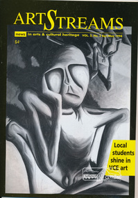
Journal, Peter Doughtery, ArtStreams: News in arts and cultural heritage; Vol. 3, No. 2, Apr-May 1998, 1998
... Eltham District Historical Society Inc 728 Main Rd Eltham melbourne Vol. 3, No. 2, Apr-May 1998 CONTENTS TOP CATS FOR '97 Emerging talent from our local schools 3 BOOK REVIEW A Small Unsigned Painting 6 LAND SHAPES Eltham artist Nel ten Wolde captures Australian images 7 REVIVING RAVENSWOOD Grand old Ivanhoe mansion restored to its former glory 9 ART IN A VEGE SHOP Murals brighten an organic greengrocer's shop 12 ADDRESSING SOCIAL CONCERNS Literary festival brings critical writers together 14 PHOTOGRAPHY Local student shows her talent 16 WOUNDEDNESS AND HEALING Australian artist in London exhibits in Eltham 18 CD REVIEW 22 SHORT STORY 23 BOOK REVIEW 25 MURALS a charming sense of community 27 EXHIBITION AT HEIDE 28 EVENT - ABORIGINAL CELEBRATION 29 ART OF PRINTMAKERS 30 ART SERVICES & TEACHING 32 "Peter Dougherty has been involved in the local art scene for many years. ...Vol. 3, No. 2, Apr-May 1998 CONTENTS TOP CATS FOR '97 Emerging talent from our local schools 3 BOOK REVIEW A Small Unsigned Painting 6 LAND SHAPES Eltham artist Nel ten Wolde captures Australian images 7 REVIVING RAVENSWOOD Grand old Ivanhoe mansion restored to its former glory 9 ART IN A VEGE SHOP Murals brighten an organic greengrocer's shop 12 ADDRESSING SOCIAL CONCERNS Literary festival brings critical writers together 14 PHOTOGRAPHY Local student shows her talent 16 WOUNDEDNESS AND HEALING Australian artist in London exhibits in Eltham 18 CD REVIEW 22 SHORT STORY 23 BOOK REVIEW 25 MURALS a charming sense of community 27 EXHIBITION AT HEIDE 28 EVENT - ABORIGINAL CELEBRATION 29 ART OF PRINTMAKERS 30 ART SERVICES & TEACHING 32 "Peter Dougherty has been involved in the local art scene for many years. As publisher and editor of the arts magazine Artstreams, his comments on the various branches of the arts are widely respected. His "The Arts" column in the Diamond Valley Leader presents a brief summary for a much wider cross section of the local community. Peter also operates his own gallery and the Artstreams Cafe at the St Andrews market. Peter has a wealth of knowledge about present day and historical aspects of local art and artists." - Eltham District Historical Society Newsletter No. 161, March 2005Colour front and back cover with feature articles and literary pieces with photographs and advertisements printed in black and white. 36 pages, 30 cm. Vol. 1, no. 1 (Nov. 1996) - Vol. 10, no. 5 (summer ed. 2005/06) art streams, faces coffee place, jessie glavin, katie williams, kelly almond, michelle ceravolo, mariella mckinlay, rochelle carr, manningham gallery, stephen sheding, dynamic vegies, nel ten wolde, pool & spa care centre, bi-wize quality paints, llobex image wizards, east ivanhoe gallery, ravenswood, marguerite marshall, theresa martin, soni stecker, virginia trioli, robert dessaix, lauren williams, robert manne, chris jurewicz, moira rayner, marela mckinley, wendy donald, anne redmond, wingrove cottage community clinic, were street cafe, rob vines, ashley cross, serge de leucio, michael conolan, daniel chable, pietro ristorante grossi, lucinda mcknight, litfest 98, morag fraser, michele lonsdale, wintyre recital gallery, murals, port jackson press australia, epping secondary college, bulleen art & garden centre, christmas hills, museum of modern art at heide, nillumbik gayip, mye woonbah dancers, intaglio, violeta capovska, christina cordero, elizabeth dobrilla, belinda fox, david frazer, melinda schawel, amanda woodford, pandora journal, ward sagar, wholefood delights, dymocks booksellers -
 Eltham District Historical Society Inc
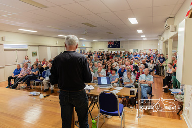
Photograph, Peter Pidgeon, Greg Johnson moves a motion to present to Council the community's view regarding the proposed land sale/development; Eltham Community Town Hall Meeting, Eltham Senior Citizen's Centre, 13 October 2018, 13 Oct 2018
... Eltham District Historical Society Inc 728 Main Rd Eltham melbourne Community meeting held at the Eltham Senior Citizen's Centre to discuss Nillumbik Shire Council's advertised proposal to sell the former Shire Office site at 895 Main Road and the Eltham War Memorial complex of buildings at 903-907 Main Road; 13 October 2018 895 main road, 903-907 main road, community meeting, eltham pre-school, eltham shire office, eltham war memorial, eltham war memorial hall, infant welfare centre, nillumbik shire council, senior citizen's centre Born digital image Greg Johnson moves a motion to present to Council the community's view regarding the proposed land sale/development; Eltham Community Town Hall Meeting, Eltham Senior Citizen's Centre, 13 October 2018 Photograph Peter Pidgeon ...Community meeting held at the Eltham Senior Citizen's Centre to discuss Nillumbik Shire Council's advertised proposal to sell the former Shire Office site at 895 Main Road and the Eltham War Memorial complex of buildings at 903-907 Main Road; 13 October 2018Born digital image895 main road, 903-907 main road, community meeting, eltham pre-school, eltham shire office, eltham war memorial, eltham war memorial hall, infant welfare centre, nillumbik shire council, senior citizen's centre