Showing 15 items matching "melville island"
-
 Ballarat Heritage Services
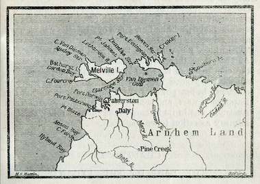
Map, Melville Island
... Melville Island......melville island...Melville Island Map ...Copy of a map from 'A Short History of Australia' by Ernest Scott.map, explorers, exploration, melville island, tiwi islands, arnhem land, palmerston, daly, croker island, bathurst island, pine creek, daly river -
 Ballarat Heritage Services
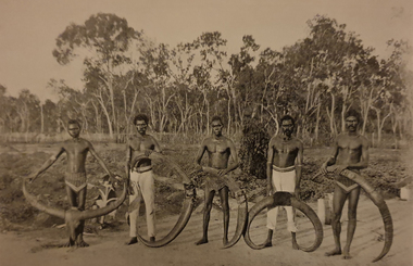
Image - Black and White, Aborigines with Buffalo Horns at Meville Island, c1903, c1903
... ...melville island...Melville Island, Northern Territory, Australia...Ballarat Heritage Services PO Box 2209 Bakery Hill Post Office goldfields aborigines melville island tiwi Aborigines with Buffalo Horns at Meville Island, c1903 Image - Black and White ...aborigines, melville island, tiwi -
 Moorabbin Air Museum
Map (item) - Aeronautical colour map Feb 1944 cloth backed extends to port Augusta Newcastle and Melbourne 1960'c A4 size civil aviation airport terminal maps of Melbourne Brisbane Darwin Adelaide Hobart Launceston Perth 1943 Cloth map of Burma 1943 cloth map of Indonesia 1957 war office Cloth map of Singapore Bangkok North Borneo Ordinance maps 3108 Brunswick bay 3222 Halls creek 3232 Alice Springs 3098 Cape Wessel 3221 Newcastle waters 3223 Broome 3109 Darwin 3097 Torres Strait 3110 Groote Eylandt 3099 Melville Island 3112 Cooktown 3459 Port Augusta 3340 Brisbane 3470 Melbourne 3456 Sydney 3469 Hamilton, Maps of Australia and environs
... Aeronautical colour map Feb 1944 cloth backed extends to port Augusta Newcastle and Melbourne 1960'c A4 size civil aviation airport terminal maps of Melbourne Brisbane Darwin Adelaide Hobart Launceston Perth 1943 Cloth map of Burma 1943 cloth map of Indonesia 1957 war office Cloth map of Singapore Bangkok North Borneo Ordinance maps 3108 Brunswick bay 3222 Halls creek 3232 Alice Springs 3098 Cape Wessel 3221 Newcastle waters 3223 Broome 3109 Darwin 3097 Torres Strait 3110 Groote Eylandt 3099 Melville Island 3112 Cooktown 3459 Port Augusta 3340 Brisbane 3470 Melbourne 3456 Sydney 3469 Hamilton...Moorabbin Air Museum Moorabbin Airport 12 First Street Moorabbin melbourne Cloth maps fair condition, the rest Good condition Maps of Australia and environs Map Aeronautical colour map Feb 1944 cloth backed extends to port Augusta Newcastle and Melbourne 1960'c A4 size civil aviation airport terminal maps of Melbourne Brisbane Darwin Adelaide Hobart Launceston Perth 1943 Cloth map of Burma 1943 cloth map of Indonesia 1957 war office Cloth map of Singapore Bangkok North Borneo Ordinance maps 3108 Brunswick bay 3222 Halls creek 3232 Alice Springs 3098 Cape Wessel 3221 Newcastle waters 3223 Broome 3109 Darwin 3097 Torres Strait 3110 Groote Eylandt 3099 Melville Island 3112 Cooktown 3459 Port Augusta 3340 Brisbane 3470 Melbourne 3456 Sydney 3469 Hamilton ... -
Federation University Historical Collection
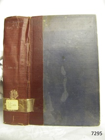
Book, Northern Territory of South Australia Report Resulting from the Explorations by the Government Geologist, 1906, 1906
... ...melville island...It includes a chapter of Bathurst Island and Melville Island, Primitive Methhods of Chinese Mining, Early Days of Mining in the Northern Territory Images include sandbank at low tide, Douglas River, Granite at Union Hill, Night Cliff, East Point, union hill, zapopan gold mine Brook's Creek, Blow Gold Mine Yam Creek, Daly River Copper Mine, Mount Ellison Copper Mine, Point Charles Lighthouse, Blacks Camp near Point Charles Lighthouse, The Venture Stranded on a Daly River Sandbank, Hyland Bay Natives, Boabab Trees at Blunder Bay, The Wai Hoi, Mouth of Fitzmaurice River, Point Blaze Natives, Fort Hill and Old Gulnare Jetty Port Darwin, Large Anthill, Daly RIver Natives, Wargie Natives, L.C.E. ...Barker Library (top floor) Mount Helen goldfields northern territory of south australia geology l. o'loughlin douglas river bathurst island melville island apsley straight chinese aboriginal Pale blue soft covered geological and general report. ...Pale blue soft covered geological and general report. It includes a chapter of Bathurst Island and Melville Island, Primitive Methhods of Chinese Mining, Early Days of Mining in the Northern Territory Images include sandbank at low tide, Douglas River, Granite at Union Hill, Night Cliff, East Point, union hill, zapopan gold mine Brook's Creek, Blow Gold Mine Yam Creek, Daly River Copper Mine, Mount Ellison Copper Mine, Point Charles Lighthouse, Blacks Camp near Point Charles Lighthouse, The Venture Stranded on a Daly River Sandbank, Hyland Bay Natives, Boabab Trees at Blunder Bay, The Wai Hoi, Mouth of Fitzmaurice River, Point Blaze Natives, Fort Hill and Old Gulnare Jetty Port Darwin, Large Anthill, Daly RIver Natives, Wargie Natives, L.C.E. Gee, H.Y.L. Brown, H. Basedow. F.J. Williamson, Aboriginal crew (Pedro, Peter, Tobatchie, Bubs, Loman), Henry Roberts, Schollert's Grave It also includes a large folder Geological Map of the North-Western District Northern Territory of South Australia. northern territory of south australia, geology, l. o'loughlin, douglas river, bathurst island, melville island, apsley straight, chinese, aboriginal -
Tatura Irrigation & Wartime Camps Museum
Folder, Australian Military Forces, Australian Archives Brighton May 1991, revised May 1941
... Also the last page has details of the first Australian POW taken by Japanese on Australia soil and the first Japanese POW on Melville Island and captured by the aboriginals, one of who spoke fluent Japanese....Also the last page has details of the first Australian POW taken by Japanese on Australia soil and the first Japanese POW on Melville Island and captured by the aboriginals, one of who spoke fluent Japanese. ...The interesting records of Japanese civilian internees in Camp 4. The Rev Len Kentish, pilot Hajime Toyashima and take to Cowra where he became one of the ringleaders of the infamous breakout and died during the attempt and made available with the efforts of the Knee family with the cooperation of the Australian Archives, also Shepparton News cutting, Keith Esson, Alan Fitzgerald. Italian farming soldiers.Seven Australian military forces internee/POW service and casualty forms, overprinted Japanese in individual plastic envelopes, clear plastic cover with a green border and back cover. Also the last page has details of the first Australian POW taken by Japanese on Australia soil and the first Japanese POW on Melville Island and captured by the aboriginals, one of who spoke fluent Japanese.On the green border - Australian Archives Brighton May 1991 Camp 4 Yasukichi and Terese Mupvakami and family internment camp records.rev len kentish, hajime toyashima, cowra, camp 4, keith esson, alan fitzgerald, italian farming soldiers, cowra breakout, shepparton news, japanese internees -
 Bendigo Military Museum
Administrative record - Royal Australian Survey Corps - Central Command Operation Order C/1/61 Northern Territory 1961, DAD Svy, HQ Central Command , Keswick Barracks, SA, 1961
... The task is to acquire Survey Control for the production of maps coving the following 1:250 000 map areas of Alligator River, Mt Evelyn, Coburg Peninsula, (including the offshore Islands, Melville Island and Bathurst Island. The Operation Order details the tasks for the 6 x Officers (or equivalent) and 34 x OR's (or equivalent) and the support that was allocated including Frigate HMAS Gasgoyne, LSM landing craft, Trucks amphibian (DUKW), Helicopter and Cessna aircraft....The task is to acquire Survey Control for the production of maps coving the following 1:250 000 map areas of Alligator River, Mt Evelyn, Coburg Peninsula, (including the offshore Islands, Melville Island and Bathurst Island. The Operation Order details the tasks for the 6 x Officers (or equivalent) and 34 x OR's (or equivalent) and the support that was allocated including Frigate HMAS Gasgoyne, LSM landing craft, Trucks amphibian (DUKW), Helicopter and Cessna aircraft. ...This is a Central Command Operation Order for the Royal Australian Survey Corps to conduct a Survey Operation in Northern Territory in 1961. The task is to acquire Survey Control for the production of maps coving the following 1:250 000 map areas of Alligator River, Mt Evelyn, Coburg Peninsula, (including the offshore Islands, Melville Island and Bathurst Island. The Operation Order details the tasks for the 6 x Officers (or equivalent) and 34 x OR's (or equivalent) and the support that was allocated including Frigate HMAS Gasgoyne, LSM landing craft, Trucks amphibian (DUKW), Helicopter and Cessna aircraft.A 11 x page foolscap size paper report and 1 x foldout map Annex held together with a paper clip. Two hole punched.Hand written File Number in top RH Corner "101-310-4". Distribution stamp in top LH Corner. Hand written No7 in Top RH Corner.royal australian survey corps, rasvy, fortuna, army survey regiment, army svy regt -
 Warrnambool and District Historical Society Inc.
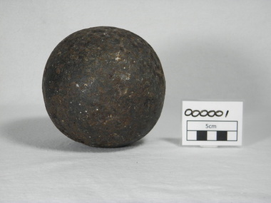
Weapon - Artefact, Cannon ball, pre 1830
... By the time of the 1830's 18lb cannons were largely obsolete and removed from service Australia used 18 calibre cannons in Northern Australia at Port Essington and Fort Dundas (Melville Island) Perhaps this cannon ball has no real connection with Australia and came as ballast from some other country....By the time of the 1830's 18lb cannons were largely obsolete and removed from service Australia used 18 calibre cannons in Northern Australia at Port Essington and Fort Dundas (Melville Island) Perhaps this cannon ball has no real connection with Australia and came as ballast from some other country. ...This cannon ball formed the basis of a discussion with artillerist Peter Webster and historical society members in 2011. The following ideas were put forward. It was approximately 5 inches in diameter and weighed 10lb, Such cannon balls were used in an 18 calibre cannon, which were used only on ships. (12 calibre guns were field artillery). Australia was behind England in its artillery use and used hand me downs. In the 1800's Australia did an audit of artillery and cleared out those no longer in use. By the time of the 1830's 18lb cannons were largely obsolete and removed from service Australia used 18 calibre cannons in Northern Australia at Port Essington and Fort Dundas (Melville Island) Perhaps this cannon ball has no real connection with Australia and came as ballast from some other country.This is one of the more interesting items in our collection and there has been much conjecture over the years as to the story of how it ended up in Warrnambool. In that way it has built its own mystery and provenanceRound metal ball measuring 5 inches in diameter, weighing 10lb. The surface is pitted with the original surface visible in some parts.defence, war, ships, cannon ball, exploration, warrnambool, warrnambool history, warrnambool cannonball -
 Flagstaff Hill Maritime Museum and Village
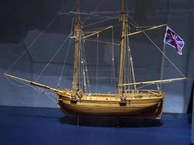
Craft - Ship Model, H.M.S. Lady Nelson, 1988
... Her life as an exploration vessel ended while accompanying HMS 'Tamar' to Melville Island in 1825, the 'Lady Nelson' was captured and later abandoned by pirates off the island of Babar (Indonesia). ...Her life as an exploration vessel ended while accompanying HMS 'Tamar' to Melville Island in 1825, the 'Lady Nelson' was captured and later abandoned by pirates off the island of Babar (Indonesia). ...This model of the ship H.M.S. Lady Nelson was researched and built as the vessel Lady Nelson by David Lumsden, a professional ship model builder. His Majesty's Armed Survey Vessel Lady Nelson was commissioned in 1799 to survey the coast of Australia. This vessel was purpose-built before the British Admiralty requested plans for a Schooner for Port Jackson. At the time large parts of the Australian coast were unmapped and Britain had claimed only part of the continent. The British Government were concerned that, in the event of settlers of another European power becoming established in Australia, any future conflict in Europe would lead to a widening of the conflict into the southern hemisphere to the detriment of the trade that Britain sought to develop. Against this background, Lady Nelson was chosen to survey and establish sovereignty over strategic parts of the continent. Lady Nelson left Portsmouth on 18 March 1800 and arrived at Sydney on 16th December 1800 after having been the first vessel to reach the east coast of Australia via the Bass Strait. Before that date, all vessels had sailed around the southern tip of Tasmania to reach their destination. Lady Nelson's survey work commenced shortly after she arrived in Sydney, initially in the Bass Strait area. She was involved in the discovery of Port Phillip, on the coast of Victoria, in establishing settlements on the River Derwent and at Port Dalrymple in Tasmania. She also successfully chartered much of the Victorian coastline and was heavily involved with the exploration of the Queensland coast with Matthew Flinders; investigated the Hunter River; made numerous visits to New Zealand and Norfolk Island and was involved in the founding of numerous settlements. In comparison to most colonial vessels, the Lady Nelson was technically unique she was fitted with sliding keels, or centreboards, and water-tight trunks reaching to the deck. Captain Schank invented these sliding keels that, when raised, reduced her draught to less than six feet. Her life as an exploration vessel ended while accompanying HMS 'Tamar' to Melville Island in 1825, the 'Lady Nelson' was captured and later abandoned by pirates off the island of Babar (Indonesia). This brought the vessel's 25 years of coastal exploration and navigation to a close.The Lady Nelson made was the first British ship to survey of the southern or south-western coast of Australia and traverse the Bass Strait. The vessel holds a special place in Australia's history of exploration as the first to explore and establish settlements in the then-new British colony of Van Diemans Land. The model gives an insight into what life must have been like onboard sailing vessels of the time and Australia's early history of establishment and exploration. This model acts as an important legacy of the full-scale ship which no longer survives. Ship model of the 60 ton British brig HMS Lady Nelson. Timber model of a two-masted brig with rigging but no sails, displaying the British Union Jack flag. The ship is in a glass exhibition display case on metal stand. HMS Lady Nelsonflagstaff hill, warrnambool, shipwrecked coast, flagstaff hill maritime museum, maritime museum, shipwreck coast, flagstaff hill maritime village, great ocean road, by captain john schanck, sliding keels or centreboards, lady nelson, british brig hms lady nelson, david lumsden ship model builder, lieutennant james grant, bass strait discovery, surveying king island and port phillip bay, philip gidley king -
 Stawell Historical Society Inc
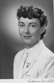
Photograph, Clare Best ne Kinsella and photos of farm
... After they were married Keith was drafted up to Darwin while Clare worked at a Roman Catholic Mission on Melville Island where she had many adventures establishing a farm at the Mission. ...After they were married Keith was drafted up to Darwin while Clare worked at a Roman Catholic Mission on Melville Island where she had many adventures establishing a farm at the Mission. ...7250 Clare Kinsella born 1907 c1940 -1 Clare Kinsella in navy Signals uniform c1943 -2 Clare Kinsella in navy Signals uniform c1943 -3 William Jennings Kinsella with stationery engine at farm Maya Park Lubeck -4 Clare Kinsella with dog Pencil at Magdala farm Lubeck -5 Clare Kinsella with dog Pencil at Station Creek Magdala Farm Lubeck -6 Clare Kinsella with dog Pencil at Magdala Farm Lubeck -7 Clare with child at Magdala Farm -8 Clare with pet cocky “Cocky” -9 Horse at farm -10 William Jennings Kinsella at 93 with ham radio Clare Best nee Kinsella Clare was born December 26, 1907 at “Eyrecourt” on the corner of Scallan and Ligar Streets in Stawell. Clare was the second child of William Jennings Kinsella and Sarah Kinsella nee Peardon. In 1910 the family moved to live at ‘Mayo Park” Lubeck. In 1920’s Mayo Park was sold and a new house was built on a farm nearby called “Magdala” after the mine in which Mr Kinsella’s family had been involved. Clare attended Lubeck State Public School with her older brother Tom, younger sister Carmel and youngest brother Bill. In 1941 Clare left the farm to join the Womens Royal Australian Navy. Her WRAN service number was WR/38 and in the 4 years of service had advanced to Leading Telegraphist. Initially stationed at HMAS Harman in Canberra then Townsville Naval Radio Station Queensland and finally discharged at HMAS Lonsdale, Port Melbourne.. Clare married Keith Charles Best in 1946 also a Leading Telegraphist of HMAS Harman. After they were married Keith was drafted up to Darwin while Clare worked at a Roman Catholic Mission on Melville Island where she had many adventures establishing a farm at the Mission. Keith was discharged in 1952 and they both worked establishing a Pineapple Farm/ General Store at Noonamah just out of Darwin. Later they moved to a remote farm on the Daily River but after 10 years and 7 years of constant floods they retired to Harvey Bay Queensland. Clare led an active life and died in 1999, her ashes are in the Jennings/Kinsella Vault in the Stawell Cemetery. B/W Photos -
 Flagstaff Hill Maritime Museum and Village
Book, The Logbooks of The Lady Nelson, 1915
... Grant helped establish the first settlement on Melville Island in Northern Australia. The Lady Nelson was used to transport cargo, civilians and convicts and to source pigs from Timor. ...Grant helped establish the first settlement on Melville Island in Northern Australia. The Lady Nelson was used to transport cargo, civilians and convicts and to source pigs from Timor. ...This hardcover book, The logbooks of the 'Lady Nelson' : with the journal of her first commander, Lieutenant James Grant, R.N., by Ida Lee (Mrs Charles Bruce Marriott) was published over 100 years after the Lady Nelson arrived in Australia to navigate and survey this ‘new colony’. Included in the book are sixteen charts and illustrations from the originals in the Admiralty Library, showing the surveyed land and water. The transcribed Contents, below, summarise the trips of the Lady Nelson during this time. Book’s Content PLUS text of the Chart of ‘Part of Bass Strait’ - Chapter 1: The Lady Nelson built with centreboards. Her voyage to Sydney under James Grant. The first ship to pass through Bass Strait. - Chapter 2: Returns to explore the Strait. Her visits to Jervis Bay and to Western Port in 1801 - Chapter 3: Colonel Paterson and Lieutenant Grant survey Hunter River - Chapter 4: Murray appointed commander of the Lady Nelson. His voyage to Norfolk Island. - Chapter 5: Murray’s exploration of Bass Strait. - Chapter 6: Discovery of Port Phillip. - Chapter 7: The Lady Nelson in company with HMS Investigator examines the North-Eastern shores of Australia. - Chapter 8: The French ships in Bass Strait. The founding of Hobart. - Chapter 9: Symons succeeds Curtoys as commander of the Lady Nelson. His voyages to Tasmania, Port Phillip and New Zealand. - Chapter 10: The Lady Nelson in Tasmania. The founding of Port Dalrymple. - Chapter 11: The Estramina is brought to Sydney. The Lady Nelson visits Norfolk Island and Port Dalrymple. - Chapter 12: Tippahee and his four sons are conveyed to New Zealand in the Lady Nelson. - Chapter 13: The Lady Nelson accompanies HMS Tamar to Melville Island. - Chapter 14: The loss of the Lady Nelson Text included with the ‘Chart of Bass Strait’ … “Part of Bass Strait, including the discoveries made by Acting Lieut. J. Murray, commander of His Majesty’s armed surveying vessel Lady Nelson, between November 1801 and March 1802. By command of His Excellency Governor King.” “This chart, which bears Murray’s autograph, shows his explorations of Western Port, Port Phillip and King Island. It should be noted that Flinders Island is named Grand Capuchin. This is one of the charts referred to as "unfortunately missing” in the Historical Records of N.S. Wales, vol. iv. P. 764” The story of the Lady Nelson In 1798 the British Admiralty ordered a cutter of 60 tons to be built along the design of the armed cutter Trial that was developed by Captain John Schanck, with three sliding keels or centreboards that could be individually raised and lowered, for use on the River Thames. The new cutter was to be named Lady Nelson. Philip Gidley King, prior to taking up his appointment as third Governor of the colony of New South Wales, was in England at the time of the Lady Nelson’s fit-out and was aware of the need for such a ship for survey work in the colony in New South Wales. He convinced Captain Schanck, the Commissioner of Transport in England, to construct and rig the Lady Nelson as a brig rather than a cutter, keeping the feature of the three sliding keels, which would be very useful for mapping in shallow waters. The new Lady Nelson was launched at Deptford, England on the River Thames in November 1798, with the official commission to discover and survey the unknown parts of the coast of New Holland (Australia) and establish British sovereignty over the continent. The Lady Nelson sailed from Portsmouth, England on March 1800 under the command of Lieutenant James Grant. She carried an armament of two original and four extra brass carronade carriage guns and set sail as part of a convoy heading to Port Jackson, in New South Wales, New Holland. After a while she continued to sail on her own. Her journey was troubled with problems at times; damaged and broken keels, troublesome crew and leaking topsides between the waterline and the deck due to poor seals. She arrived at the Cape of Good Hope in July and waited for the winter to pass to avoid the strong winds of the ‘Roaring Forties’. While at the Cape, Grant received a despatch to travel to Port Jackson via the newly discovered Bass Strait, rather than the usual route via the tip of Van Diemen’s Land (Tasmania). This also gave him the opportunity to survey the strait on the way. He departed the Cape in October and in December he made his first sighting of New Holland near Mount Gambier in what is now South Australia. A report by Ecclestone in 2012, ‘The Early Charting of Victoria’s Coastline’, mentions that Grant charted and named Capes Banks and Northumberland, and sighted inland hills that he named Mt Gambier and Mt Schanck, the latter after the designer of his ship. Grant then reached the south-western shores of what is now Victoria on 3-4 December 1800, and from Cape Bridgewater he examined the coast eastward to Cape Patton. Although he had not continuously sighted the coast in the vicinity of Port Fairy and Warrnambool, the western part of Victoria became known as Grant’s Land. The Lady Nelson continued eastward and passed through Bass Strait, becoming the first vessel to reach the east coast of New Holland from the west, and arrived at her destination of Port Jackson later in December 1800. Grant, in the Lady Nelson, then left Port Jackson and began survey work. He discovered Port Phillip on Victoria’s coast and explored King Island, he helped establish the first European settlement in Tasmania on the Derwent River, and Port Dalrymple, Newcastle and Port Macquarie. He made several trips from Norfolk Island to Hobart Town. Governor Macquarie sailed on with him to Van Diemen’s Land for a tour of inspection in 1811. Grant helped establish the first settlement on Melville Island in Northern Australia. The Lady Nelson was used to transport cargo, civilians and convicts and to source pigs from Timor. In February 1825 the Lady Nelson sailed again for Timor and never returned. One report said that “Every soul on board, we regret to state, was cruelly massacred, and the hull of the vessel was seen some time after with the name painted on her stern.” The hull was sighted on the island of Babar, which is almost 200 kilometres east of Timor. This particular copy of the book ... This item is from the ‘Pattison Collection’, a collection of books and records that was originally owned by the Warrnambool Mechanics’ Institute, which was founded in Warrnambool in 1853. By 1886 the Warrnambool Mechanics’ Institute (WMI) had grown to have a Library, Museum and Fine Arts Gallery, with a collection of “… choice productions of art, and valuable specimens in almost every branch and many wonderful national curiosities are now to be seen there, including historic relics of the town and district.” It later included a School of Design. Although it was very well patronised, the lack of financial support led the WMI in 1911 to ask the City Council to take it over. In 1935 Ralph Pattison was appointed as City Librarian to establish and organise the Warrnambool Library as it was then called. When the WMI building was pulled down in 1963 a new civic building was erected on the site and the new Warrnambool Library, on behalf of the City Council, took over all the holdings of the WMI. At this time some of the items were separated and identified as the ‘Pattison Collection’, named after Ralph Pattison. Eventually the components of the WMI were distributed from the Warrnambool Library to various places, including the Art Gallery, Historical Society and Flagstaff Hill. Later some were even distributed to other regional branches of Corangamite Regional Library and passed to and fro. It is difficult now to trace just where all of the items have ended up. The books at Flagstaff Hill Maritime Village generally display stamps and markings from Pattison as well as a variety of other institutions including the Mechanics’ Institute itself. RALPH ERIC PATTISON Ralph Eric Pattison was born in Rockhampton, Queensland, in 1891. He married Maude Swan from Warrnambool in 1920 and they set up home in Warrnambool. In 1935 Pattison accepted a position as City Librarian for the Warrnambool City Council. His huge challenge was to make a functional library within two rooms of the Mechanics’ Institute. He tirelessly cleaned, cleared and sorted a disarrayed collection of old books, jars of preserved specimens and other items reserved for exhibition in the city’s museum. He developed and updated the library with a wide variety of books for all tastes, including reference books for students; a difficult task to fulfil during the years following the Depression. He converted all of the lower area of the building into a library, reference room and reading room for members and the public. The books were sorted and stored using a cataloguing and card index system that he had developed himself. He also prepared the upper floor of the building and established the Art Gallery and later the Museum, a place to exhibit the many old relics that had been stored for years for this purpose. One of the treasures he found was a beautiful ancient clock, which he repaired, restored and enjoyed using in his office during the years of his service there. Ralph Pattison was described as “a meticulous gentleman whose punctuality, floorless courtesy and distinctive neat dress were hallmarks of his character, and ‘his’ clock controlled his daily routine, and his opening and closing of the library’s large heavy doors to the minute.” Pattison took leave during 1942 to 1945 to serve in the Royal Australian Navy, Volunteer Reserve as Lieutenant. A few years later he converted one of the Museum’s rooms into a Children’s Library, stocking it with suitable books for the younger generation. This was an instant success. In the 1950’s he had the honour of being appointed to the Victorian Library Board and received more inspiration from the monthly conferences in Melbourne. He was sadly retired in 1959 after over 23 years of service, due to the fact that he had gone over the working age of council officers. However he continued to take a very keen interest in the continual development of the Library until his death in 1969 This book about the logbooks of the Lady Nelson is locally significant for its association with the brig Lady Nelson, in which Lt. James Grant made the first documented European discovery of the area later known as Warrnambool in December 1800. This book is also nationally significant for its association with Grant in the Lady Nelson being the first to sail from west to east through Bass Strait, opening up a shorter, faster route to the colony of Port Jackson rather than going all the way south around Van Diemen’s Land. The book is nationally significant for its contents of the logbooks of the journeys of the Lady Nelson under various commanders and the copies of the charts created from the surveyed information and the new land of Australia was discovered. This book is also significant for its association with the full-size non-sailing replica of the Lady Nelson from Mount Gambier’s visitor centre, which was restored by Flagstaff Hill’s Master Boat Builder in Warrnambool in 2012, and with a ship mode of the Lady Nelson in our Collection The Pattison Collection, along with other items at Flagstaff Hill Maritime Village, was originally part of the Warrnambool Mechanics' Institute’s collection. The Warrnambool Mechanics’ Institute Collection is primarily significant in its totality, rather than for the individual objects it contains. Its contents are highly representative of the development of Mechanics' Institute libraries across Australia, particularly Victoria. A diversity of publications and themes has been amassed, and these provide clues to our understanding of the nature of and changes in the reading habits of Victorians from the 1850s to the middle of the 20th century. The collection also highlights the Warrnambool community’s commitment to the Mechanics’ Institute, reading, literacy and learning in the regions, and proves that access to knowledge was not impeded by distance. These items help to provide a more complete picture of our community’s ideals and aspirations. The Warrnambool Mechanics Institute book collection has historical and social significance for its strong association with the Mechanics Institute movement and the important role it played in the intellectual, cultural and social development of people throughout the latter part of the nineteenth century and the early twentieth century. The collection of books is a rare example of an early lending library and its significance is enhanced by the survival of an original collection of many volumes. The Warrnambool Mechanics' Institute’s publication collection is of both local and state significance. The Logbooks of The Lady Nelson Author: Ida Lee ( Mrs Charles Bruce Marriott) Publisher: Grafton & Co Date: 1915Label on spine with typed text RA 910.994 LEE Inside front cover has a sticker that reads Warrnambool Mechanics Institute and Free Library shipwrecked-coast, flagstaff-hill, warrnambool, flagstaff-hill-maritime-museum, maritime-museum, shipwreck-coast, flagstaff-hill-maritime-village, shipwrecked-artefact, book, warrnambool library, warrnambool mechanics’ institute, warrnambool city librarian, mechanics’ institute library, victorian library board, warrnambool books and records, warrnambool children’s library, great ocean road, the logbooks of the lady nelson, ida lee, mrs charles bruce marriott, captain john schanck, sliding keels or centreboards, lady nelson, british brig hms lady nelson, lieutennant james grant, bass strait discovery, surveying king island and port phillip bay, philip gidley king, survey map -
 Queenscliffe Maritime Museum
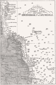
Map - B & W coastal map of Hinchinbrook Island to Cape Melville in Queensland, Coastal map Queensland Hinchinbrook Is to Cape Melville, Before donation in 1987
... B & W coastal map of Hinchinbrook Island to Cape Melville in Queensland...Map from unknown book of Queensland coast Hinchinbrook Island to Cape Melville, pre 1987...Queenscliffe Maritime Museum 2 Wharf St Queenscliff geelong-and-the-bellarine-peninsula Australian coastal maps Australian coastal maps old maps of Australian coast Reverse " NIL " Map from unknown book of Queensland coast Hinchinbrook Island to Cape Melville, pre 1987 Coastal map Queensland Hinchinbrook Is to Cape Melville Map B & W coastal map of Hinchinbrook Island to Cape Melville in Queensland ...Australian coastal mapsAustralian coastal mapsMap from unknown book of Queensland coast Hinchinbrook Island to Cape Melville, pre 1987Reverse " NIL "old maps of australian coast -
 Numurkah & District Historical Society
Slides / Photos / Brush/comb sets / Telescopic view photo set / Tie pin
... Numurkah & District Historical Society Old Bank Building cnr Melville and Knox Street (118-120 Melville St) Numurkah the-murray All of these items were donated by Jock Adams (He was on the Ulupna Island Committee and hence some of the donated photos Jock Adams, tie-pin, photos, brush-comb set, telescopic view photos, slides Photos - Morgan's Beach, Coonanga Homestead, Barmah Hotel, Ulupna Island Slides - Moira Forest shrubs etc 2 x Brush comb sets Sword/Dagger Tie Pin King George V Coronation Stereo Telescopic View photo set (1911) Slides / Photos / Brush/comb sets / Telescopic view photo set / Tie pin ...All of these items were donated by Jock Adams (He was on the Ulupna Island Committee and hence some of the donated photosPhotos - Morgan's Beach, Coonanga Homestead, Barmah Hotel, Ulupna Island Slides - Moira Forest shrubs etc 2 x Brush comb sets Sword/Dagger Tie Pin King George V Coronation Stereo Telescopic View photo set (1911)jock adams, tie-pin, photos, brush-comb set, telescopic view photos, slides -
 Numurkah & District Historical Society
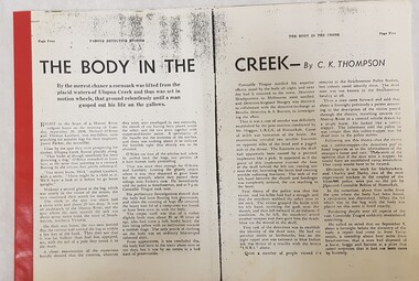
Ulupna Island murder
... Numurkah & District Historical Society Old Bank Building cnr Melville and Knox Street (118-120 Melville St) Numurkah the-murray These are stories are related to the murder at Ulupna Island, 1898 Ulupna Island, murder, crime, detective stories, police, redgum forest as per photos above a. ...These are stories are related to the murder at Ulupna Island, 1898a. Photocopy from Famous Detective Stories "The Body in the Creek" (Stapled at the side, with red binding tape) b. Photocopy from Famous Detective Stories "Death Stalks the Redgums" (Stapled at the side, with red Binding Tape c. Famous Detective Stories magazine Volume 1 No. 6 May 1947as per photos aboveulupna island, murder, crime, detective stories, police, redgum forest -
 National Vietnam Veterans Museum (NVVM)
Ceremorial Object, White Cross
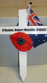
... National Vietnam Veterans Museum (NVVM) 25 Veterans Drive Newhaven phillip-island-and-the-bass-coast O'Hanlon Robert Melville O'Hanlon, Robert Melville 016657 White p[ainted wooden cross, knitted poppy, Australian flag White Cross Ceremorial Object Ceremorial Object ...White p[ainted wooden cross, knitted poppy, Australian flagO'Hanlon, Robert Melville 016657o'hanlon, robert melville -
 Returned Nurses RSL Sub-branch
Newspaper - Newspaper clipping, [The West Australian], War dead honoured at early service, [18/4/88]
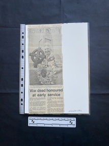
... Melville Civic Square saw an early Anzac service on [17 April 1988], as the square's civic clock tower was dedicated as a memorial to local residents who fought for Australia. The service included a requiem by Mrs Vivian Statham, the sole survivor of the Banka Island...Melville Civic Square saw an early Anzac service on [17 April 1988], as the square's civic clock tower was dedicated as a memorial to local residents who fought for Australia. The service included a requiem by Mrs Vivian Statham, the sole survivor of the Banka Island ...Melville Civic Square saw an early Anzac service on [17 April 1988], as the square's civic clock tower was dedicated as a memorial to local residents who fought for Australia. The service included a requiem by Mrs Vivian Statham, the sole survivor of the Banka Island massacre.A newspaper clipping of a large black and white photo of an older woman smiling and holding a memorial wreath in front of a clock tower, above two small columns of text.' "The West Australian ' 18/4/88 ' [blue ink, along top]vivian bullwinkel, japanese, sumatra, jack howson, bicentennial authority, don ingersole