Showing 47 items matching "metropolitan avenue"
-
 Whitehorse Historical Society Inc.
Letter - Correspondence, Offer to buy land in Metropolitan Avenue, Tunstall, 1936
... Offer to buy land in Metropolitan Avenue, Tunstall...Metropolitan Avenue...Kiker to buy Lot 2 Metropolitan Avenue, Nunawading and an acknowledgement by Council....Kiker to buy Lot 2 Metropolitan Avenue, Nunawading and an acknowledgement by Council. ...An offer by T.J. Kiker to buy Lot 2 Metropolitan Avenue, Nunawading and an acknowledgement by Council.An offer by T.J. Kiker to buy Lot 2 Metropolitan Avenue, Nunawading and an acknowledgement by Council.An offer by T.J. Kiker to buy Lot 2 Metropolitan Avenue, Nunawading and an acknowledgement by Council.metropolitan avenue, nunawading, lot 2, shire of blackburn and mitcham, kiker, t.j. -
 Whitehorse Historical Society Inc.
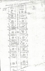
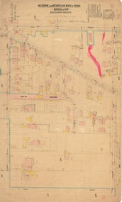
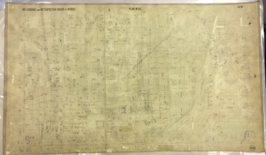
Document, Metropolitan Avenue, n.d
... Metropolitan Avenue...metropolitan avenue...Plan of subdivision of 321.162 and 321.163 Metropolitan Avenue between Whitehorse (or Lilydale) Road and the railway in Nunawading....Metropolitan Avenue Document Document ...Plan of subdivision of 321.162 and 321.Plan of subdivision of 321.162 and 321.163 Metropolitan Avenue between Whitehorse (or Lilydale) Road and the railway in Nunawading.Plan of subdivision of 321.162 and 321.metropolitan avenue, nunawading, fargher, j.j., bond, j., bell, k., anderson, g., blackman, r., skinner, t., westwall, m., goodwin, george augustus, cornwall, i., hesketh, henderson, e., timms, m.a., tolson, horan, william, southey, land subdivision -
Whitehorse Historical Society Inc.
Document, Certificate of Title, 1909, 1934
... ...Metropolitan Avenue... Lot 18 Metropolitan Avenue, Tunstall, and correspondence re outstanding rates....Certificate of Title for house and Lot 18 Metropolitan Avenue, Tunstall, and correspondence re outstanding rates....Whitehorse Historical Society Inc. 2-10 Deep Creek Road Mitcham melbourne Lot 18 Metropolitan Avenue, Tunstall, and correspondence re outstanding rates. ...Certificate of Title for houseCertificate of Title for house and Lot 18 Metropolitan Avenue, Tunstall, and correspondence re outstanding rates.Certificate of Title for house shire of blackburn and mitcham, rates, land titles, weston, thomas henry, metropolitan avenue, nunawading -
 Whitehorse Historical Society Inc.
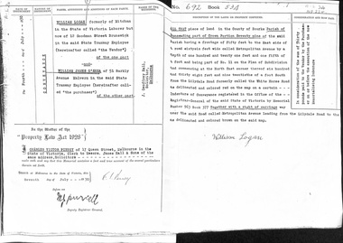
Document - Land Title, Record of Land site, 07/07/1930
... metropolitan avenue...Copy of record of sale by William Logan to William James O'Shea of land on Metropolitan Avenue, Nunawading...metropolitan avenue nunawading logan william o'shea william james land sales Copy of record of sale by William Logan to William James O'Shea of land on Metropolitan Avenue, Nunawading Record of Land site Document Land Title ...Copy of record of sale by William Logan to William James O'Shea of land on Metropolitan Avenue, Nunawadingmetropolitan avenue, nunawading, logan, william, o'shea, william james, land sales -
 Whitehorse Historical Society Inc.
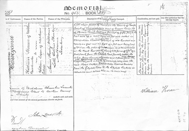
Legal record - Land Title, Land Memorial, 1860
... ...metropolitan avenue...Land Memorial No 963, Book 377, relating to transfer of land in Metropolitan Avenue, Nunawading from William Horan to William Logan...horan william logan metropolitan avenue nunawading land sales Land Memorial No 963, Book 377, relating to transfer of land in Metropolitan Avenue, Nunawading from William Horan to William Logan Land Memorial Legal record Land Title ...Land Memorial No 963, Book 377, relating to transfer of land in Metropolitan Avenue, Nunawading from William Horan to William Loganhoran, william, logan, metropolitan avenue, nunawading, land sales -
Whitehorse Historical Society Inc.
Article, Railway Work Piles Up, 2016
... ...Metropolitan Avenue...Over 1000 piles of up to 1 metre in diameter will be bored along the length of the 9m deep cutting, every 2.7 metres between Blackburn Railway Station and Metropolitan Avenue, Nunawading....Whitehorse Historical Society Inc. 2-10 Deep Creek Road Mitcham melbourne Blackburn Railway Crossing Blackburn Railway Station Metropolitan Avenue Nunawading Over 1000 piles of up to 1 metre in diameter will be bored along the length of the 9m deep cutting, every 2.7 metres between Blackburn Railway Station and Metropolitan Avenue, Nunawading. ...Over 1000 piles of up to 1 metre in diameter will be bored along the length of the 9m deep cutting, every 2.7 metres between Blackburn Railway Station and Metropolitan Avenue, Nunawading.Over 1000 piles of up to 1 metre in diameter will be bored along the length of the 9m deep cutting, every 2.7 metres between Blackburn Railway Station and Metropolitan Avenue, Nunawading.Over 1000 piles of up to 1 metre in diameter will be bored along the length of the 9m deep cutting, every 2.7 metres between Blackburn Railway Station and Metropolitan Avenue, Nunawading.blackburn railway crossing, blackburn railway station, metropolitan avenue, nunawading -
 Whitehorse Historical Society Inc.
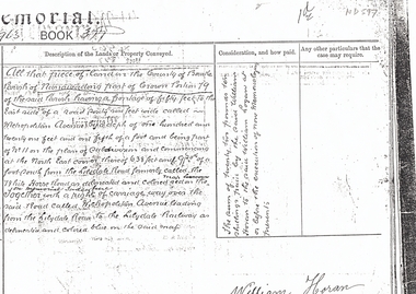
Document, Land Sale, n.d
... metropolitan avenue...Photocopy from extract from Memorial Book 377 No 963 recording conveyance of land bounded by Whitehorse Road and Metropolitan Avenue, part Crown Portion 79, Parish of Nunawading from William Logan to William Horan....Whitehorse Historical Society Inc. 2-10 Deep Creek Road Mitcham melbourne metropolitan avenue nunawading whitehorse road logan william horan land sales Extract from Memorial Book 377 No 963 recording conveyance of land bounded by Whitehorse Road and Metropolitan Avenue, Photocopy from extract from Memorial Book 377 No 963 recording conveyance of land bounded by Whitehorse Road and Metropolitan Avenue, part Crown Portion 79, Parish of Nunawading from William Logan to William Horan. ...Extract from Memorial Book 377 No 963 recording conveyance of land bounded by Whitehorse Road and Metropolitan Avenue,Photocopy from extract from Memorial Book 377 No 963 recording conveyance of land bounded by Whitehorse Road and Metropolitan Avenue, part Crown Portion 79, Parish of Nunawading from William Logan to William Horan.Extract from Memorial Book 377 No 963 recording conveyance of land bounded by Whitehorse Road and Metropolitan Avenue,metropolitan avenue, nunawading, whitehorse road, logan, william, horan, land sales -
Whitehorse Historical Society Inc.
Document, Notice of default in rate payments, 1933, 1937
... Metropolitan Avenue...Whitehorse Historical Society Inc. 2-10 Deep Creek Road Mitcham melbourne Solicitor's letter requesting more information about the sale of land to T.J. Kiker. Metropolitan Avenue Nunawading Lot 2 Shire of Blackburn and Mitcham Kiker T.J. ...A notice of default in rate payments to Shire of Blackburn and Mitcham to the Freehold Investment and Banking Co of Australia LtdA notice of default in rate payments to Shire of Blackburn and Mitcham to the Freehold Investment and Banking Co of Australia Ltd and a solicitor's letter requesting more information about the sale of land to T.J. Kiker.A notice of default in rate payments to Shire of Blackburn and Mitcham to the Freehold Investment and Banking Co of Australia Ltdmetropolitan avenue, nunawading, lot 2, shire of blackburn and mitcham, kiker, t.j., freehold investment and banking company of australia ltd, rates -
 Whitehorse Historical Society Inc.
Document, Estate of James Keogh, 1897
... ...metropolitan avenue...Whitehorse Historical Society Inc. 2-10 Deep Creek Road Mitcham melbourne keogh james wills thomas ann o'shannassey st mitcham mitcham road albert street haines street springfield road nunawading springvale road metropolitan avenue watts street box hill victoria crescent mont albert whitehorse road surrey hills lightfoot street Copy of the will of James Keogh Lot 19a, 3r, 38 perches part of allot 193b Jan 1897 179 pounds /17/9 Copy of the will of James Keogh, January 1897 involving land in Box Hill, Surrey Hills, Tunstall, Mitcham and Nunawading. ...Copy of the will of James KeoghCopy of the will of James Keogh, January 1897 involving land in Box Hill, Surrey Hills, Tunstall, Mitcham and Nunawading.Copy of the will of James Keoghkeogh, james, wills, thomas, ann, o'shannassey st, mitcham, mitcham road, albert street, haines street, springfield road, nunawading, springvale road, metropolitan avenue, watts street, box hill, victoria crescent, mont albert, whitehorse road, surrey hills, lightfoot street -
 Eltham District Historical Society Inc
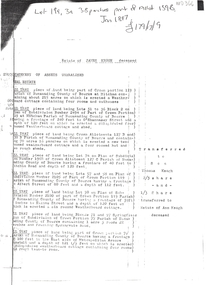
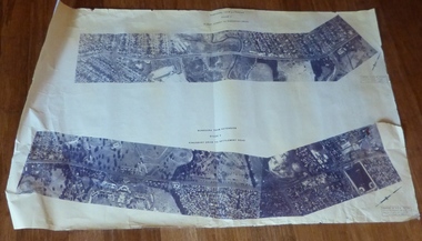
Photograph - Aerial Photograph, Landata, Eltham, Luck St; Bible St to Beard St, Dec. 1945
... Eltham District Historical Society Inc 728 Main Rd Eltham melbourne Centred on present day Eltham East Primary School, east of Main Rd along Luck St to Beard St Historic Aerial Imagery Source: Landata.vic.gov.au Aerial Photo Details: Project No :5 Project : MELBOURNE AND METROPOLITAN AREA PROJECT Run : 36 Frame : 60548 Date : 12/1945 Film Type : B/W Camera : EAG4 Flying Height : 10200 Scale : 6000 Film Number : 195 GDA2020 : 37°42'46"S, 145°09'18"E MGA2020 : 337371, 5824456 (55) Melways : 22 A4 (ed. 42) Aerial Photo Eltham Arthur Street Beard Street Bible Street Eltham East Primary School frank street henry street Luck Street Stanley Avenue Wycliffe Crescent Neil Webster Collection A3 photo print and electronic PDF file Eltham, Luck St; Bible St to Beard St Photograph Aerial Photograph Landata ...Centred on present day Eltham East Primary School, east of Main Rd along Luck St to Beard St Historic Aerial Imagery Source: Landata.vic.gov.au Aerial Photo Details: Project No :5 Project : MELBOURNE AND METROPOLITAN AREA PROJECT Run : 36 Frame : 60548 Date : 12/1945 Film Type : B/W Camera : EAG4 Flying Height : 10200 Scale : 6000 Film Number : 195 GDA2020 : 37°42'46"S, 145°09'18"E MGA2020 : 337371, 5824456 (55) Melways : 22 A4 (ed. 42)aerial photo, eltham, arthur street, beard street, bible street, eltham east primary school, frank street, henry street, luck street, stanley avenue, wycliffe crescent, neil webster collection -
 Sunshine and District Historical Society Incorporated
Photograph - Maribyrnong River and Valley
... Photocopy of Photograph Maribyrnong Munitions Factory 1938|Newspaper article Brimbank Messenger 29 October 2002 Our bond with the Maltese|Newspaper article The Herald Friday 24 February 1989 Yes Melbourne does have another river|Typed report History of Maribyrnong Steering Committee Reports|Typed notes of Steering Committee History of Maribyrnong Meeting held 7 June 1989|Typed notes 27 April 1989 History of Maribyrnong Steering Committtee Meeting|Typed notes of Steering Committee 5 April 1989|Typed notes of Steering Committee 1 March 1989|Typed notes of Steering Committee 11 January 1989|Typed notes 23 August 1988 Local History|Typed notes of Steering Committee 28 Febuary 1989|Typed report 17 November 1988 A History of Maribyrnong|Extract First Contacts I Primi Contenti|Extract Chapter 2 Maribyrnong on the map|Typed Report Migrant impact The early settlement of Maribyrnong|Photocopy of photographs Your family's photos are Maribyrnong's heritage|Typed report Maribyrnong A pictorial history|Typed report Maribyrnong History Outline|Typed report A History of Maribyrnong General Brief for the Author|Handwritten notes Research for Sunshine Council Project|Letter 18 August 1988 The History Institute|Typed report Copyright|Newspaper article Star 7 December 2004 Council moves to avert disaster|Newspaper article Brimbank Messenger 4 July 2000 Platypus potential|Newspaper article |Advocate 7 July 1993 New river bridge|Letter to Waterways and Parks division Metropolitan Parks 11 April 1985 Potential uses of Bluestone buildings|Typed Memorandum 21 January 1985 History of the Site of the Marie Hill Centre|Typed report The Ford Maribyrnong River|Typed letter from Legislative Council 6 January 1982 regarded rezoning|Extract of Poem The Haunted Castle at Maribyrnong by Martha Coxhead|Handwritten note Evan Crick Hotel dates|Brochure Historic Parkland Van Ness Avenue Sunshine|Typed notes Maribyrnong River Valley Braybrook February 1992|Typed letter 1 June 1983 Humes Site from Melbourne and Metropolitan Board of Works|Typed l etter 31 May 1982 from Historic Buildings Preservation Council re the fomer Melbourne Meat Preserving Company buildings and former Humes Pipes Site Van Ness Avenue Maribyrnong|Flyer 3 February 1803 Charles Grimes 175th Anniversary 5 February 1978|Newspaper articles Melbourne must not forget its other river|Newspaper article Sunshine Advocatge 24 February 1982 Hearing on Humes rezoning|Newspaper article Public Meeting on Future Development Plans for the former Humes site|Huge Banner Development Plan for Maribyrnong River|Newspaper article Advocate 22 February 2000 Greedy developers|Newspaper article Advocate 17 April 1996 River estate plan set for amendment|Newspaper article Advocate 8 February 2000 Bridging concern|Newspaper article Western Times 1 March 2000 Developers plan riles river residents|Newspaper article Advocate 20 February 1974 Maribyrnong a paradise|Newspaper article Messenger 15 February 2000 Plan rushed residents|Newspaper article Advocate 1 June 1983 Get tough policy on Valley|Newspaper article The Herald 11 December 1981 A community is up in arms over a threat to Victoria's heritage The battle over the bluestone. ...Maribyrnong River Maribyrnong Valley Photocopy of Photograph Maribyrnong Munitions Factory 1938|Newspaper article Brimbank Messenger 29 October 2002 Our bond with the Maltese|Newspaper article The Herald Friday 24 February 1989 Yes Melbourne does have another river|Typed report History of Maribyrnong Steering Committee Reports|Typed notes of Steering Committee History of Maribyrnong Meeting held 7 June 1989|Typed notes 27 April 1989 History of Maribyrnong Steering Committtee Meeting|Typed notes of Steering Committee 5 April 1989|Typed notes of Steering Committee 1 March 1989|Typed notes of Steering Committee 11 January 1989|Typed notes 23 August 1988 Local History|Typed notes of Steering Committee 28 Febuary 1989|Typed report 17 November 1988 A History of Maribyrnong|Extract First Contacts I Primi Contenti|Extract Chapter 2 Maribyrnong on the map|Typed Report Migrant impact The early settlement of Maribyrnong|Photocopy of photographs Your family's photos are Maribyrnong's heritage|Typed report Maribyrnong A pictorial history|Typed report Maribyrnong History Outline|Typed report A History of Maribyrnong General Brief for the Author|Handwritten notes Research for Sunshine Council Project|Letter 18 August 1988 The History Institute|Typed report Copyright|Newspaper article Star 7 December 2004 Council moves to avert disaster|Newspaper article Brimbank Messenger 4 July 2000 Platypus potential|Newspaper article |Advocate 7 July 1993 New river bridge|Letter to Waterways and Parks division Metropolitan Parks 11 April 1985 Potential uses of Bluestone buildings|Typed Memorandum 21 January 1985 History of the Site of the Marie Hill Centre|Typed report The Ford Maribyrnong River|Typed letter from Legislative Council 6 January 1982 regarded rezoning|Extract of Poem The Haunted Castle at Maribyrnong by Martha Coxhead|Handwritten note Evan Crick Hotel dates|Brochure Historic Parkland Van Ness Avenue Sunshine|Typed notes Maribyrnong River Valley Braybrook February 1992|Typed letter 1 June 1983 Humes Site from Melbourne and Metropolitan Board of Works|Typed l etter 31 May 1982 from Historic Buildings Preservation Council re the fomer Melbourne Meat Preserving Company buildings and former Humes Pipes Site Van Ness Avenue Maribyrnong|Flyer 3 February 1803 Charles Grimes 175th Anniversary 5 February 1978|Newspaper articles Melbourne must not forget its other river|Newspaper article Sunshine Advocatge 24 February 1982 Hearing on Humes rezoning|Newspaper article Public Meeting on Future Development Plans for the former Humes site|Huge Banner Development Plan for Maribyrnong River|Newspaper article Advocate 22 February 2000 Greedy developers|Newspaper article Advocate 17 April 1996 River estate plan set for amendment|Newspaper article Advocate 8 February 2000 Bridging concern|Newspaper article Western Times 1 March 2000 Developers plan riles river residents|Newspaper article Advocate 20 February 1974 Maribyrnong a paradise|Newspaper article Messenger 15 February 2000 Plan rushed residents|Newspaper article Advocate 1 June 1983 Get tough policy on Valley|Newspaper article The Herald 11 December 1981 A community is up in arms over a threat to Victoria's heritage The battle over the bluestone. ...Photocopy of Photograph Maribyrnong Munitions Factory 1938|Newspaper article Brimbank Messenger 29 October 2002 Our bond with the Maltese|Newspaper article The Herald Friday 24 February 1989 Yes Melbourne does have another river|Typed report History of Maribyrnong Steering Committee Reports|Typed notes of Steering Committee History of Maribyrnong Meeting held 7 June 1989|Typed notes 27 April 1989 History of Maribyrnong Steering Committtee Meeting|Typed notes of Steering Committee 5 April 1989|Typed notes of Steering Committee 1 March 1989|Typed notes of Steering Committee 11 January 1989|Typed notes 23 August 1988 Local History|Typed notes of Steering Committee 28 Febuary 1989|Typed report 17 November 1988 A History of Maribyrnong|Extract First Contacts I Primi Contenti|Extract Chapter 2 Maribyrnong on the map|Typed Report Migrant impact The early settlement of Maribyrnong|Photocopy of photographs Your family's photos are Maribyrnong's heritage|Typed report Maribyrnong A pictorial history|Typed report Maribyrnong History Outline|Typed report A History of Maribyrnong General Brief for the Author|Handwritten notes Research for Sunshine Council Project|Letter 18 August 1988 The History Institute|Typed report Copyright|Newspaper article Star 7 December 2004 Council moves to avert disaster|Newspaper article Brimbank Messenger 4 July 2000 Platypus potential|Newspaper article |Advocate 7 July 1993 New river bridge|Letter to Waterways and Parks division Metropolitan Parks 11 April 1985 Potential uses of Bluestone buildings|Typed Memorandum 21 January 1985 History of the Site of the Marie Hill Centre|Typed report The Ford Maribyrnong River|Typed letter from Legislative Council 6 January 1982 regarded rezoning|Extract of Poem The Haunted Castle at Maribyrnong by Martha Coxhead|Handwritten note Evan Crick Hotel dates|Brochure Historic Parkland Van Ness Avenue Sunshine|Typed notes Maribyrnong River Valley Braybrook February 1992|Typed letter 1 June 1983 Humes Site from Melbourne and Metropolitan Board of Works|Typed l etter 31 May 1982 from Historic Buildings Preservation Council re the fomer Melbourne Meat Preserving Company buildings and former Humes Pipes Site Van Ness Avenue Maribyrnong|Flyer 3 February 1803 Charles Grimes 175th Anniversary 5 February 1978|Newspaper articles Melbourne must not forget its other river|Newspaper article Sunshine Advocatge 24 February 1982 Hearing on Humes rezoning|Newspaper article Public Meeting on Future Development Plans for the former Humes site|Huge Banner Development Plan for Maribyrnong River|Newspaper article Advocate 22 February 2000 Greedy developers|Newspaper article Advocate 17 April 1996 River estate plan set for amendment|Newspaper article Advocate 8 February 2000 Bridging concern|Newspaper article Western Times 1 March 2000 Developers plan riles river residents|Newspaper article Advocate 20 February 1974 Maribyrnong a paradise|Newspaper article Messenger 15 February 2000 Plan rushed residents|Newspaper article Advocate 1 June 1983 Get tough policy on Valley|Newspaper article The Herald 11 December 1981 A community is up in arms over a threat to Victoria's heritage The battle over the bluestone. The Melbourne Meat Preserving Works|Typed report Historic Workplace Humes Site Van Ness Avenue Maribyrnong|Typed letter 1 December 1967 Explosives Factory Maribyrnong|Typed report Racing colours Rose and Black|Newspaper article The Age 28 April 1982 The western maze|Typed Minutes 4 July 1983 Meeting of the Lower Maribyrnong Conservation Group|Typed Constitution of the Lower Maribyrnong Valley Conservation Group|Typed Submission 29 April 1982 To City of Sunshine for Historic buildings preservation council classifications sub committee|Typed Minutes of Lower Maribyrnong Valley Conservation Group 26 August 1982|Typed Application for Membership form Lower Maribyrnong Valley Conservation Group|Typed Submission for a Financial Grant to the Charles Grimes 175th Anniversary Re enactment Committee|Typed Annual General Meeting 5 July 1984 Lower Maribyrnong Valley Conservation Group|Typed letter 30 July 1980 Humes Site|Typed Proposal Bluestone building|Typed Letter from University of Melbourne 11 December 1980 Meat Preserving companys works|Brochure Pipemakers Park|Typed notes Elizabeth McKinnon Mosaic mural artist|Newspaper article Sunshine Advocate 10 November 1993 Heritage site rediscovered|Newspaper article The Age 7 September 1996 Dreamtime in an industrial garden|Newspaper article The Western Times 6 December 1989 The peoples historiian|Typed report The Saltwater River Powder Magazine Jacks Magazine|Typed letter from Henry Laskowski Sunshine City Council Engineer / Planner to Gwen Goedecke Re: Melbourne Metropolitan Planning Scheme Amendment No 157 Maribyrnong Valley 26th November 1981|Newspaper article The Advocate 13th September Council to buy vital river land|Newspaper article The Age 4th September 1978 Tight controls urged over Maribyrnong|Newspaper article The Age 27th April 1988 Metropolitan Region Planning Scheme Amendment RL11|Melbourne Metropolitan Board of Works M.M.B.W. Concept plan for Maribyrnong River Development Media Release 25th January 1984|City of Sunshine The Maribyrnong River Ideas for the River Valley|Newspaper Article The Advocate 14 March 1979 River Valley Land Purchasemaribyrnong river, maribyrnong valley -
Robin Boyd Foundation
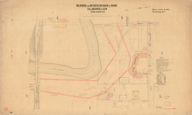
Letter, Melbourne and Metropolitan Board of Works, 31.03.1958
... Robin Boyd Foundation 290 Walsh Street South Yarra melbourne Letter to Robin Boyd regarding his letter about the proposed Eastern Suburbs Freeway to cross Riversdale Rd and Woodlands Avenue (right beside 158 Riversdale Rd, the Boyd family home). Letter Melbourne and Metropolitan Board of Works ...Letter to Robin Boyd regarding his letter about the proposed Eastern Suburbs Freeway to cross Riversdale Rd and Woodlands Avenue (right beside 158 Riversdale Rd, the Boyd family home). -
 Vision Australia
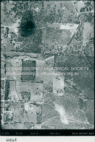
Photograph (item) - Image, Help required for Carols by Candlelight
... Various avenues were used to call for this assistance, including the circulation of Help Wanted signs at newsagent kiosks at metropolitan railway stations. ...Various avenues were used to call for this assistance, including the circulation of Help Wanted signs at newsagent kiosks at metropolitan railway stations. ...Carols by Candlelight required the assistance of the general public around Melbourne to sell programs and other items, assist ticket sales and other activities. Various avenues were used to call for this assistance, including the circulation of Help Wanted signs at newsagent kiosks at metropolitan railway stations. In this image, a woman buys something from a newsagent kiosk, whilst another person waits behind her. The newsagent smiles from behind his stack of papers, beside a Life Savers rack and in front of cigarette towers behind him. Above him is an advertisement for Goldstream tobacco. The sign attached slightly over the tobacco advertisement reads: Help Required for Carols by Candlelight commencing 27th Nov. 5 1/4 hours daily. 6 day week inc. Saturday. For 4 weeks. 80 cents per hour. If interested phone Mr Burke 511381.carols by candlelight, royal victorian institute for the blind -
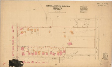
 Kew Historical Society Inc
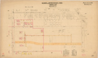
Plan, Melbourne & Metropolitan Board of Works : Borough of Kew : Detail Plan No.1590, 1905
... Numerous houses, large and small are named on the plan: ‘Cholula’, ‘Belper’, ‘The Uplands’, ‘Spring Grove’ facing Cotham Road; ‘Marion’ facing Kent Street; and ‘Kia Ora’ facing Ridgeway Avenue. Melbourne & Metropolitan Board of Works : Borough of Kew : Detail Plan No.1590 Plan Plan Melbourne and Metropolitan Board of Works City of Kew Kew Historical Society ...The Melbourne and Metropolitan Board of Works (MMBW) plans were produced from the 1890s to the 1950s. They were crucial to the design and development of Melbourne's sewerage and drainage system. The plans, at a scale of 40 feet to 1 inch (1:480), provide a detailed historical record of Melbourne streetscapes and environmental features. Each plan covers one or two street blocks (roughly six streets), showing details of buildings, including garden layouts and ownership boundaries, and features such as laneways, drains, bridges, parks, municipal boundaries and other prominent landmarks as they existed at the time each plan was produced. (Source: State Library of Victoria)This plan forms part of a large group of MMBW plans and maps that was donated to the Society by the Mr Poulter, City Engineer of the City of Kew in 1989. Within this collection, thirty-five hand-coloured plans, backed with linen, are of statewide significance as they include annotations that provide details of construction materials used in buildings in the first decade of the 20th century as well as additional information about land ownership and usage. The copies in the Public Record Office Victoria and the State Library of Victoria are monochrome versions which do not denote building materials so that the maps in this collection are invaluable and unique tools for researchers and heritage consultants. A number of the plans are not held in the collection of the State Library of Victoria so they have the additional attribute of rarity.Original survey plan, issued by the MMBW to a contractor with responsibility for constructing sewers in the area identified on the plan within the Borough of Kew. The plan was at some stage hand-coloured, possibly by the contractor, but more likely by officers working in the Engineering Department of the Borough and later Town, then City of Kew. The hand-coloured sections of buildings on the plan were used to denote masonry or brick constructions (pink), weatherboard constructions (yellow), and public buildings (grey). Surveyed by the Board of Works in 1903 and published in 1904, Plan No.1590 shows development north of Cotham Road. While this plan includes built structures in Mary Street, Cotham Road, High Street, Park Hill Road, Kent Street, Ridgeway Avenue, and Ermington Lane (now Ermington Place), only part of this section was notated and coloured in this contractor’s copy. Numerous houses, large and small are named on the plan: ‘Cholula’, ‘Belper’, ‘The Uplands’, ‘Spring Grove’ facing Cotham Road; ‘Marion’ facing Kent Street; and ‘Kia Ora’ facing Ridgeway Avenue.melbourne and metropolitan board of works, detail plans, mmbw 1590, survey plans - borough of kew, cartography -
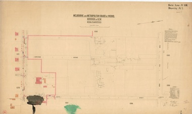
 Kew Historical Society Inc
Plan, Melbourne & Metropolitan Board of Works : Borough of Kew : Detail Plan No.1591, 1905
... Avenue. Mont Belmont was designed by the architectural firm of Reed, Henderson and Smart for William George Lilley in 1887 and was completed in 1888. Lilley was Mayor of Kew in 1887-88, a Justice of the Peace and a member of the first Board of Guardians of Kew’s St. Hilary’s Church of England. Melbourne & Metropolitan ...The Melbourne and Metropolitan Board of Works (MMBW) plans were produced from the 1890s to the 1950s. They were crucial to the design and development of Melbourne's sewerage and drainage system. The plans, at a scale of 40 feet to 1 inch (1:480), provide a detailed historical record of Melbourne streetscapes and environmental features. Each plan covers one or two street blocks (roughly six streets), showing details of buildings, including garden layouts and ownership boundaries, and features such as laneways, drains, bridges, parks, municipal boundaries and other prominent landmarks as they existed at the time each plan was produced. (Source: State Library of Victoria)This plan forms part of a large group of MMBW plans and maps that was donated to the Society by the Mr Poulter, City Engineer of the City of Kew in 1989. Within this collection, thirty-five hand-coloured plans, backed with linen, are of statewide significance as they include annotations that provide details of construction materials used in buildings in the first decade of the 20th century as well as additional information about land ownership and usage. The copies in the Public Record Office Victoria and the State Library of Victoria are monochrome versions which do not denote building materials so that the maps in this collection are invaluable and unique tools for researchers and heritage consultants. A number of the plans are not held in the collection of the State Library of Victoria so they have the additional attribute of rarity.Original survey plan, issued by the MMBW to a contractor with responsibility for constructing sewers in the area identified on the plan within the Borough of Kew. The plan was at some stage hand-coloured, possibly by the contractor, but more likely by officers working in the Engineering Department of the Borough and later Town, then City of Kew. The hand-coloured sections of buildings on the plan were used to denote masonry or brick constructions (pink), weatherboard constructions (yellow), and public buildings (grey). That area of Kew bordered by Cotham Road, Park Hill Road, Ermington Lane (now Ermington Place), and Belmont Avenue contained some of the significant homes owned by Kew pioneers. Chief among these was ‘Park Hill’ on an enormous lot facing Park Hill Road. The Jubilee History of 1910 noted, six years after this plan was drawn, that: ‘Park Hill Road, forming the southern boundary of the cemetery, takes its name from Park Hill, the residence of Mr. Thomas Judd, who has resided there since December, 1852.’ Other named houses on the plan include ‘Ferndale’ facing Cotham Road; ‘Ermington’ adjacent to Judd’s Park Hill, facing Park Hill Road; and ‘Gilden’ and ‘Mont Belmont’ facing Belmont Avenue. Mont Belmont was designed by the architectural firm of Reed, Henderson and Smart for William George Lilley in 1887 and was completed in 1888. Lilley was Mayor of Kew in 1887-88, a Justice of the Peace and a member of the first Board of Guardians of Kew’s St. Hilary’s Church of England.melbourne and metropolitan board of works, detail plans, survey plans - borough of kew, mmbw 1591, cartography -
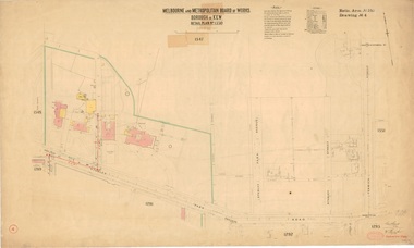
 Kew Historical Society Inc
Plan, Melbourne & Metropolitan Board of Works : Borough of Kew : Detail Plan No.1592, 1905
... Avenue, and facing Cotham Road is also included in the contract. Excluded from the contract but shown on the Plan are ‘Glendonald’, ‘Mont Belmont’ and ‘Gilden’. Melbourne & Metropolitan ...The Melbourne and Metropolitan Board of Works (MMBW) plans were produced from the 1890s to the 1950s. They were crucial to the design and development of Melbourne's sewerage and drainage system. The plans, at a scale of 40 feet to 1 inch (1:480), provide a detailed historical record of Melbourne streetscapes and environmental features. Each plan covers one or two street blocks (roughly six streets), showing details of buildings, including garden layouts and ownership boundaries, and features such as laneways, drains, bridges, parks, municipal boundaries and other prominent landmarks as they existed at the time each plan was produced. (Source: State Library of Victoria). This plan forms part of a large group of MMBW plans and maps that was donated to the Society by the Mr Poulter, City Engineer of the City of Kew in 1989. Within this collection, thirty-five hand-coloured plans, backed with linen, are of statewide significance as they include annotations that provide details of construction materials used in buildings in the first decade of the 20th century as well as additional information about land ownership and usage. The copies in the Public Record Office Victoria and the State Library of Victoria are monochrome versions which do not denote building materials so that the maps in this collection are invaluable and unique tools for researchers and heritage consultants. A number of the plans are not held in the collection of the State Library of Victoria so they have the additional attribute of rarity.Original survey plan, issued by the MMBW to a contractor with responsibility for constructing sewers in the area identified on the plan within the Borough of Kew. The plan was at some stage hand-coloured, possibly by the contractor, but more likely by officers working in the Engineering Department of the Borough and later Town, then City of Kew. The hand-coloured sections of buildings on the plan were used to denote masonry or brick constructions (pink), weatherboard constructions (yellow), and public buildings (grey). In MMBW Plan No.1592, the pink line indicates that area of the plan for which the contracting engineer was responsible. Included in the Plan are a number of primarily brick villas in a section of Belmont Avenue off Cotham Road. The house ‘Uvadale’ north of Belmont Avenue, and facing Cotham Road is also included in the contract. Excluded from the contract but shown on the Plan are ‘Glendonald’, ‘Mont Belmont’ and ‘Gilden’.melbourne and metropolitan board of works, detail plans, survey plans - borough of kew, mmbw 1592, cartography -
 Kew Historical Society Inc
Plan, Melbourne & Metropolitan Board of Works / Borough of Kew, Detail Plan No.1593, 1905
... Avenue in 1916. The most notable occupant of Clifton was William Adeney [died 1893], a pioneer of Camperdown, after which Park Street was later renamed. Melbourne & Metropolitan ...The Melbourne and Metropolitan Board of Works (MMBW) plans were produced from the 1890s to the 1950s. They were crucial to the design and development of Melbourne's sewerage and drainage system. The plans, at a scale of 40 feet to 1 inch (1:480), provide a detailed historical record of Melbourne streetscapes and environmental features. Each plan covers one or two street blocks (roughly six streets), showing details of buildings, including garden layouts and ownership boundaries, and features such as laneways, drains, bridges, parks, municipal boundaries and other prominent landmarks as they existed at the time each plan was produced. (Source: State Library of Victoria)This plan forms part of a large group of MMBW plans and maps that was donated to the Society by the Mr Poulter, City Engineer of the City of Kew in 1989. Within this collection, thirty-five hand-coloured plans, backed with linen, are of statewide significance as they include annotations that provide details of construction materials used in buildings in the first decade of the 20th century as well as additional information about land ownership and usage. The copies in the Public Record Office Victoria and the State Library of Victoria are monochrome versions which do not denote building materials so that the maps in this collection are invaluable and unique tools for researchers and heritage consultants. A number of the plans are not held in the collection of the State Library of Victoria so they have the additional attribute of rarity.Original survey plan, issued by the MMBW to a contractor with responsibility for constructing sewers in the area identified on the plan within the Borough of Kew. The plan was at some stage hand-coloured, possibly by the contractor, but more likely by officers working in the Engineering Department of the Borough and later Town, then City of Kew. The hand-coloured sections of buildings on the plan were used to denote masonry or brick constructions (pink), weatherboard constructions (yellow), and public buildings (grey). The laborious task of hand-tinting these Board of Works plans was not without hazards as is evidenced by Plan No. 1593. On the Plan, the original colourist spilt black and green ink, partially obscuring some parts. The most obvious casualty is ‘Clifton’ located on the corner of Cotham Road and Park Street [now Adeney Avenue]. Included in this Plan, and outlined in pink is that part of the section that the contracting engineer was tasked with completing. This included sewering on both sides of this part of Cotham Road, but excluded properties such as ‘Glendonald’ and ‘Monnington’. This area was to undergo a series of subdivisions including the ‘Clifton Estate’, which created housing lots on Adeney Avenue and Florence Avenue in 1916. The most notable occupant of Clifton was William Adeney [died 1893], a pioneer of Camperdown, after which Park Street was later renamed.melbourne and metropolitan board of works, detail plans, survey plans - borough of kew, mmbw 1593, cartography -
 Kew Historical Society Inc
Plan, Melbourne & Metropolitan Board of Works : Borough of Kew : Detail Plan No.1350, 1910
... Avenue, Studley Street and Fenwick Street. Each, apart from Fenwick Street was subsequently renamed. At the corner of Fenwick and Stawell Streets, the home of Joseph Butterworth Coombs, later called ‘Hope Mansell’, is represented but unnamed. Melbourne & Metropolitan ...The Melbourne and Metropolitan Board of Works (MMBW) plans were produced from the 1890s to the 1950s. They were crucial to the design and development of Melbourne's sewerage and drainage system. The plans, at a scale of 40 feet to 1 inch (1:480), provide a detailed historical record of Melbourne streetscapes and environmental features. Each plan covers one or two street blocks (roughly six streets), showing details of buildings, including garden layouts and ownership boundaries, and features such as laneways, drains, bridges, parks, municipal boundaries and other prominent landmarks as they existed at the time each plan was produced. (Source: State Library of Victoria). This plan forms part of a large group of MMBW plans and maps that was donated to the Society by the Mr Poulter, City Engineer of the City of Kew in 1989. Within this collection, thirty-five hand-coloured plans, backed with linen, are of statewide significance as they include annotations that provide details of construction materials used in buildings in the first decade of the 20th century as well as additional information about land ownership and usage. The copies in the Public Record Office Victoria and the State Library of Victoria are monochrome versions which do not denote building materials so that the maps in this collection are invaluable and unique tools for researchers and heritage consultants. A number of the plans are not held in the collection of the State Library of Victoria so they have the additional attribute of rarity.Original survey plan, issued by the MMBW to a contractor with responsibility for constructing sewers in the area identified on the plan within the Borough of Kew. The plan was at some stage hand-coloured, possibly by the contractor, but more likely by officers working in the Engineering Department of the Borough and later Town, then City of Kew. The hand-coloured sections of buildings on the plan were used to denote masonry or brick constructions (pink), weatherboard constructions (yellow), and public buildings (grey). MMBW Plan No. 1350 depicts the western end of Studley Park on the north side of the Studley Park Road. ‘Raheen’, then the home of Sir Henry Wrixon is named, the plan identifying those parts of the house that were built of brick and timber. The two houses between Raheen and the River Yarra are also shown. Other parts of the plan show neighbouring streets: Yarra Street, Studley Park Avenue, Studley Street and Fenwick Street. Each, apart from Fenwick Street was subsequently renamed. At the corner of Fenwick and Stawell Streets, the home of Joseph Butterworth Coombs, later called ‘Hope Mansell’, is represented but unnamed.melbourne and metropolitan board of works, detail plans, mmbw 1350, cartography -
 Kew Historical Society Inc
Plan, Melbourne and Metropolitan Board of Works, Melbourne & Metropolitan Board of Works : Borough of Kew : Detail Plan No.1294 & 1295, 1904
... While an earlier sale of the southern section of Byram had created Tara Avenue in 1927, the demolition of the house in 1960 enabled the extension of Tara Avenue northward. Melbourne & Metropolitan Board of Works : Borough of Kew : Detail Plan No.1294 & 1295 Plan Melbourne and Metropolitan Board of Works ...The Melbourne and Metropolitan Board of Works (MMBW) plans were produced from the 1890s to the 1950s. They were crucial to the design and development of Melbourne's sewerage and drainage system. The plans, at a scale of 40 feet to 1 inch (1:480), provide a detailed historical record of Melbourne streetscapes and environmental features. Each plan covers one or two street blocks (roughly six streets), showing details of buildings, including garden layouts and ownership boundaries, and features such as laneways, drains, bridges, parks, municipal boundaries and other prominent landmarks as they existed at the time each plan was produced. (Source: State Library of Victoria). This plan forms part of a large group of MMBW plans and maps that was donated to the Society by the Mr Poulter, City Engineer of the City of Kew in 1989. Within this collection, thirty-five hand-coloured plans, backed with linen, are of statewide significance as they include annotations that provide details of construction materials used in buildings in the first decade of the 20th century as well as additional information about land ownership and usage. The copies in the Public Record Office Victoria and the State Library of Victoria are monochrome versions which do not denote building materials so that the maps in this collection are invaluable and unique tools for researchers and heritage consultants. A number of the plans are not held in the collection of the State Library of Victoria so they have the additional attribute of rarity.Original survey plan, issued by the MMBW to a contractor with responsibility for constructing sewers in the area identified on the plan within the Borough of Kew. The plan was at some stage hand-coloured, possibly by the contractor, but more likely by officers working in the Engineering Department of the Borough and later Town, then City of Kew. The hand-coloured sections of buildings on the plan were used to denote masonry or brick constructions (pink), weatherboard constructions (yellow), and public buildings (grey).The streets and built structures in MMBW Detail Plan 1294 & 1295 were surveyed in 1903 and released to contractors in 1904. This plan is one of two in the collection where the lithographers amalgamated two separate plans. Both plans include sections of Studley Park. Dominating the south and west corners of Kew Junction are the Clifton and Kew Hotels. The Kew Hotel, owned by Patrick O’Shaughnessy was one of the oldest in Kew. MMBW plans were amended over time to take account of new subdivisions such as that which created Merrion Place. Of the four mansions shown in Studley Park Road, three remain – ‘Field Place’, the home of Frances Henty, ‘Leaghur’ and ‘Darley’. ‘Byram’ (later ‘Goathland’, then ‘Tara Hall’) was an architectural marvel. Designed in 1888 by E.G. Kilburn for the paper magnate George Ramsden, it was demolished in 1960. While an earlier sale of the southern section of Byram had created Tara Avenue in 1927, the demolition of the house in 1960 enabled the extension of Tara Avenue northward.melbourne and metropolitan board of works, detail plans, mmbw 1294, mmbw 1295, cartography -
 Kew Historical Society Inc
Plan, Melbourne & Metropolitan Board of Works : Borough of Kew : Detail Plan No.1301, 1910
... Avenue) and ‘Fairhaven’ [unnamed] in Stevenson Street. The gardens of the two David Syme owned mansions of ‘Blythswood’ and ‘Rockingham’, stretching down to the River Yarra, are also represented. Melbourne & Metropolitan ...The Melbourne and Metropolitan Board of Works (MMBW) plans were produced from the 1890s to the 1950s. They were crucial to the design and development of Melbourne's sewerage and drainage system. The plans, at a scale of 40 feet to 1 inch (1:480), provide a detailed historical record of Melbourne streetscapes and environmental features. Each plan covers one or two street blocks (roughly six streets), showing details of buildings, including garden layouts and ownership boundaries, and features such as laneways, drains, bridges, parks, municipal boundaries and other prominent landmarks as they existed at the time each plan was produced. (Source: State Library of Victoria)This plan forms part of a large group of MMBW plans and maps that was donated to the Society by the Mr Poulter, City Engineer of the City of Kew in 1989. Within this collection, thirty-five hand-coloured plans, backed with linen, are of statewide significance as they include annotations that provide details of construction materials used in buildings in the first decade of the 20th century as well as additional information about land ownership and usage. The copies in the Public Record Office Victoria and the State Library of Victoria are monochrome versions which do not denote building materials so that the maps in this collection are invaluable and unique tools for researchers and heritage consultants. A number of the plans are not held in the collection of the State Library of Victoria so they have the additional attribute of rarity.Original survey plan, issued by the MMBW to a contractor with responsibility for constructing sewers in the area identified on the plan within the Borough of Kew. The plan was at some stage hand-coloured, possibly by the contractor, but more likely by officers working in the Engineering Department of the Borough and later Town, then City of Kew. The hand-coloured sections of buildings on the plan were used to denote masonry or brick constructions (pink), weatherboard constructions (yellow), and public buildings (grey). Throughout its history, the land in what is known today as Studley Ward of the City of Boroondara has been subject to continuing subdivision. This is evident in Plan 1301, where later hands have modified the original map to include streets created subsequent to the printing of the plan in 1904. Other annotations such as the ‘Reserved for Road Purposes’ beside the Yarra never eventuated. The plan continued to be modified to at least 1953, when a later hand noted that a particular site was ‘Property site P. McIntyre house’ in Swinton Avenue. Two significant houses in the area are outlined on the plan: ‘Swinton’ on the corner of the streets then named Effey and Maud Streets (now Swinton Avenue) and ‘Fairhaven’ [unnamed] in Stevenson Street. The gardens of the two David Syme owned mansions of ‘Blythswood’ and ‘Rockingham’, stretching down to the River Yarra, are also represented.melbourne and metropolitan board of works, detail plans, mmbw 1301, cartography -
 Power House Rowing Club
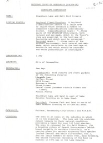
Newspaper clipping, Power House in Regatta Double, 1959
... Power House Rowing Club 164 Alexandra Avenue South Yarra melbourne Power House in Regatta Double Power House scored a double by winning the maiden fours and maiden pairs a the Metropolitan on Sunday. ...Power House in Regatta Double Power House scored a double by winning the maiden fours and maiden pairs a the Metropolitan on Sunday. -
 Whitehorse Historical Society Inc.
Document, Landscape Submission, c 1976
... avenue...city of nunawading...melbourne and metropolitan board of works...Whitehorse Historical Society Inc. 2-10 Deep Creek Road Mitcham melbourne blackburn lake sanctuary waratah crescent blackburn jeffery street hill street boongarry avenue linum street laurel grove acacia avenue city of nunawading melbourne and metropolitan board of works furness park camberwell grammar school A landscape submission written for the National Trust of Australia (Victoria) for Blackburn Lake and the Bell Bird Streets. ...A landscape submission written for the National Trust of Australia (Victoria) for Blackburn Lake and the Bell Bird Streets.A landscape submission written for the National Trust of Australia (Victoria) for Blackburn Lake and the Bell Bird Streets. Definitions given of boundaries of the Lake area, ownership, housing and gardens. Photographs and map.A landscape submission written for the National Trust of Australia (Victoria) for Blackburn Lake and the Bell Bird Streets.blackburn lake sanctuary, waratah crescent, blackburn, jeffery street, hill street, boongarry avenue, linum street, laurel grove, acacia avenue, city of nunawading, melbourne and metropolitan board of works, furness park, camberwell grammar school -
 Whitehorse Historical Society Inc.
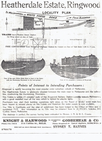
Document, Heatherdale Estate, Ringwood, 1919
... Whitehorse Historical Society Inc. 2-10 Deep Creek Road Mitcham melbourne land subdivision heatherdale estate whitehorse road mitcham melbourne and metropolitan board of works peers w.h. coane j.m. h.e. knight & harwood godbehear & co haynes sydney t walter street witt street victory street purches frederick walter Brochure advertising 52 lots, Heatherdale Estate, Ringwood (now Mitcham) to be auctioned September 1919. Brochure advertising 52 lots, Heatherdale Estate, Ringwood (now Mitcham) to be auctioned September 1919. Station Street on the plan is now Victory Street and a Railway Avenue ...Brochure advertising 52 lots, Heatherdale Estate, Ringwood (now Mitcham) to be auctioned September 1919.Brochure advertising 52 lots, Heatherdale Estate, Ringwood (now Mitcham) to be auctioned September 1919. Station Street on the plan is now Victory Street and a Railway Avenue is shown which does not now exist.Brochure advertising 52 lots, Heatherdale Estate, Ringwood (now Mitcham) to be auctioned September 1919.land subdivision, heatherdale estate, whitehorse road, mitcham, melbourne and metropolitan board of works, peers, w.h., coane, j.m., h.e., knight & harwood, godbehear & co, haynes, sydney t, walter street, witt street, victory street, purches, frederick walter -
 Kew Historical Society Inc
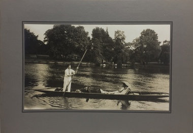
Photograph - John Duncan Brownlee and friends, Yarra River, The Artorium, 1920s
... Metropolitan Opera from 1937 to 1957. After his move to Paris in 1923, he is recorded as revisiting Australia in 1928 as a member of the Melba-Williamson Company, and 24 years later in 1952. The photograph of Brownlee and the Gardners in a punt on the Yarra, while putatively dated to 1925, must be from earlier in the 1920s before his move to Paris, or later during the Melba-Williamson Company season. Before his move to Paris in 1923, Brownlee had lived in Belmont Avenue...Metropolitan Opera from 1937 to 1957. After his move to Paris in 1923, he is recorded as revisiting Australia in 1928 as a member of the Melba-Williamson Company, and 24 years later in 1952. The photograph of Brownlee and the Gardners in a punt on the Yarra, while putatively dated to 1925, must be from earlier in the 1920s before his move to Paris, or later during the Melba-Williamson Company season. Before his move to Paris in 1923, Brownlee had lived in Belmont Avenue ...This mounted and framed photograph of a group of friends punting on the River Yarra has a number of historic and artistic associations. The photograph is primarily important as an informal photograph of the Australian baritone John Donald Mackenzie Brownlee (1900-1969), whose international career at the world's major opera houses from 1927 until his retirement in 1958 included singing at Melba's Covent Garden farewell in 1926, to recordings in the 1930s of a major series of Mozart operas in Glyndebourne Festival productions, conducted by Fritz Busch. Brownlee, born in Geelong, won the gold medal as champion vocalist at the South Street competitions in Ballarat in 1921. Moving to Paris in 1923 he began study with the French baritone, Dinh Gilly, making his operatic debut at the Trianon Lyrique in Montmartre in 1926. The most significant periods of his operatic career were with the Paris Opera from 1927 to 1936, and at the Metropolitan Opera from 1937 to 1957. After his move to Paris in 1923, he is recorded as revisiting Australia in 1928 as a member of the Melba-Williamson Company, and 24 years later in 1952. The photograph of Brownlee and the Gardners in a punt on the Yarra, while putatively dated to 1925, must be from earlier in the 1920s before his move to Paris, or later during the Melba-Williamson Company season. Before his move to Paris in 1923, Brownlee had lived in Belmont Avenue, Kew, where he must have developed a friendship with the Gardners. The photograph has additional artistic significance as it was produced at 'The Artorium', James Beament's design studio next to the Hawthorn Town Hall at 362 Burwood Road. With a home at 33 Uvadale Road (designed by Eric Nicholls, who managed the architectural practice of Walter Burley and Marion Mahony Grifffin from 1924 to 1932), Beament painted a number of significant murals for the Griffin practice, including those at the Capitol Theatre in Melbourne.A photograph of recreational activities on the River Yarra. The photograph is historically significant as a professionally produced photograph of the Australian operatic baritone John Brownlee, either before his move to Paris in 1923, or in 1928 during the Melba-Williamson Company operatic tour of Australia. The photograph has additional aesthetic significance as it was produced in James Beament's Hawthorn Studio - The Artorium - at 362 Burwood Road, next to the Hawthorn Town Hall.Framed photograph of John Duncan Brownlee, the Australian tenor, with Enid Gardner and friend in a punt on the Yarra River. Brownlee was born in Geelong but before his move to Paris in 1923, he lived for a period in Belmont Avenue, Kew. Three labels on reverse. 1. "John Duncan Brownlee, Operatic Star, originally of Geelong later resident of Kew at Belmont Av, on the pole. Also in the punt - Edith Gardner a friend. The Gardners lived on the east corner of Edgevale Rd. & Cotham. Approx. 1925." 2. "This picture is the property of Kew Historical Society 1/4/79". 3. Tel. Hawthorn 842 THE ARTORIUM ...."john brownlee (tenor), punting, recreation - yarra river (kew), james beament, the artorium -- 362 burwood road -- hawthorn (vic.) -
 Camberwell Historical Society
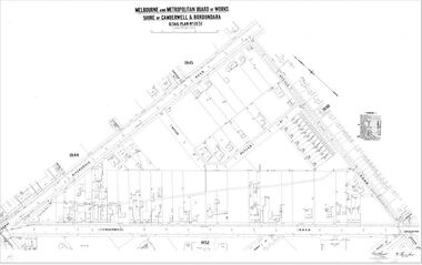
Map (Item) - MMBW map, Melbourne and Metropolitan Board of Works, Melbourne and Metropolitan Board of Works - Shire of Boroondara and Camberwell - Detail Plan no. 1851, July 1904
... Metropolitan Board of Works Map Camberwell Cartography Lithographer JEM, exd. JWD, July 1904, no. 81, 40P. 15W. MMBW Detail Plan showing Camberwell Junction, Camberwell Road, Riversdale Road and Avenue Road - dated July 1904 Melbourne and Metropolitan Board of Works - Shire of Boroondara and Camberwell - Detail Plan no. 1851 Map MMBW map Melbourne and Metropolitan Board of Works ...Lithographer JEM, exd. JWD, July 1904, no. 81, 40P. 15W.melbourne and metropolitan board of works, map, camberwell, cartography -
 Kew Historical Society Inc
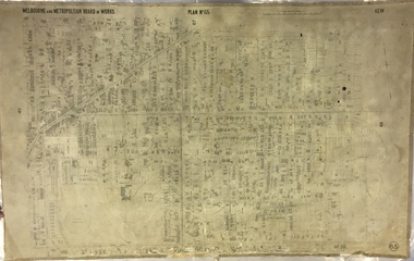
Map, MMBW, MMBW Plan No.65 Kew & Heidelberg, 1900-1910
... As these were working documents, information was added to them long after the period of their initial production and distribution. melbourne & metropolitan board of works mmbw maps mmbw plans borough of kew cartography MELBOURNE AND METROPOLITAN BOARD OF WORKS / PLAN NO. 65 / KEW & HEIDELBERG Early map of part of the Borough of Kew, created in the first decade of the twentieth century, at a scale 160 ft to 1 inch. The map covers what was then the south central part of Kew, bordered on its north by Malmsbury Street, in the west by Florence Avenue, in the south by Barkers Road, and in the east by Princess Street. ...The Melbourne and Metropolitan Board of Works (MMBW) was established by an act of the Victorian Parliament in 1890 to prepare for and to implement a sewerage and water reticulation system across what was then inner Melbourne, its surrounding and middle distance suburbs, including Kew. The MMBW was disbanded in 1991.The map collection of the Kew Historical Society has at its core the historic maps assembled and originally stored in the City Engineer's Department of the City of Kew. These include maps in a number of scales. The vast majority of maps were produced by the MMBW in the first two decades of the twentieth century, and are solid working maps, backed by linen for durability. These maps are historically significant to Kew, the City of Boroondara and to the history of the development of state utilities in Victoria. A number of the Kew maps have additional details added by former municipal officers, including the levels reached by various floods. As these were working documents, information was added to them long after the period of their initial production and distribution.Early map of part of the Borough of Kew, created in the first decade of the twentieth century, at a scale 160 ft to 1 inch. The map covers what was then the south central part of Kew, bordered on its north by Malmsbury Street, in the west by Florence Avenue, in the south by Barkers Road, and in the east by Princess Street. The map shows the extent of urban development by that time, prominent institutions and the outlines of built structures in the municipality. Contour lines were added in ink to the map at a later stage.MELBOURNE AND METROPOLITAN BOARD OF WORKS / PLAN NO. 65 / KEW & HEIDELBERGmelbourne & metropolitan board of works, mmbw maps, mmbw plans, borough of kew, cartography -
 Kew Historical Society Inc
Map, MMBW, MMBW Plan No.66 Kew, 1900-1910
... As these were working documents, information was added to them long after the period of their initial production and distribution. melbourne & metropolitan board of works mmbw maps mmbw plans borough of kew cartography MELBOURNE AND METROPOLITAN BOARD OF WORKS / PLAN NO. 66 / KEW Early map of part of the Borough of Kew, created in the first decade of the twentieth century, at a scale 160 ft to 1 inch. The map covers what was then the south eastern part of Kew, bordered on its north by Adeney Avenue, in the west by Sackville Street, in the south by Barkers Road, and in the east by Burke Road. ...The Melbourne and Metropolitan Board of Works (MMBW) was established by an act of the Victorian Parliament in 1890 to prepare for and to implement a sewerage and water reticulation system across what was then inner Melbourne, its surrounding and middle distance suburbs, including Kew. The MMBW was disbanded in 1991.The map collection of the Kew Historical Society has at its core the historic maps assembled and originally stored in the City Engineer's Department of the City of Kew. These include maps in a number of scales. The vast majority of maps were produced by the MMBW in the first two decades of the twentieth century, and are solid working maps, backed by linen for durability. These maps are historically significant to Kew, the City of Boroondara and to the history of the development of state utilities in Victoria. A number of the Kew maps have additional details added by former municipal officers, including the levels reached by various floods. As these were working documents, information was added to them long after the period of their initial production and distribution.Early map of part of the Borough of Kew, created in the first decade of the twentieth century, at a scale 160 ft to 1 inch. The map covers what was then the south eastern part of Kew, bordered on its north by Adeney Avenue, in the west by Sackville Street, in the south by Barkers Road, and in the east by Burke Road. The map shows the extent of urban development by that time, prominent institutions and the outlines of built structures in the municipality. Contour lines were added in ink to the map at a later stage.MELBOURNE AND METROPOLITAN BOARD OF WORKS / PLAN NO. 66 / KEW melbourne & metropolitan board of works, mmbw maps, mmbw plans, borough of kew, cartography -
 Kew Historical Society Inc
Map, MMBW, MMBW Plan No.67 Kew, 1900-1910
... As these were working documents, information was added to them long after the period of their initial production and distribution. melbourne & metropolitan board of works mmbw maps mmbw plans borough of kew cartography MELBOURNE AND METROPOLITAN BOARD OF WORKS / PLAN NO. 67 / KEW Early map of part of the Borough of Kew, created in the first decade of the twentieth century, at a scale 160 ft to 1 inch. The map covers what was then the north central part of Kew, bordered on its north by the Outer Circle Railway Spruzen and Beresford Avenues, in the west by Princess Street, in the south by High Street, and in the east by (about) Belford Road. ...The Melbourne and Metropolitan Board of Works (MMBW) was established by an act of the Victorian Parliament in 1890 to prepare for and to implement a sewerage and water reticulation system across what was then inner Melbourne, its surrounding and middle distance suburbs, including Kew. The MMBW was disbanded in 1991.The map collection of the Kew Historical Society has at its core the historic maps assembled and originally stored in the City Engineer's Department of the City of Kew. These include maps in a number of scales. The vast majority of maps were produced by the MMBW in the first two decades of the twentieth century, and are solid working maps, backed by linen for durability. These maps are historically significant to Kew, the City of Boroondara and to the history of the development of state utilities in Victoria. A number of the Kew maps have additional details added by former municipal officers, including the levels reached by various floods. As these were working documents, information was added to them long after the period of their initial production and distribution.Early map of part of the Borough of Kew, created in the first decade of the twentieth century, at a scale 160 ft to 1 inch. The map covers what was then the north central part of Kew, bordered on its north by the Outer Circle Railway Spruzen and Beresford Avenues, in the west by Princess Street, in the south by High Street, and in the east by (about) Belford Road. The map shows the extent of urban development by that time, prominent institutions and the outlines of built structures in the municipality. Contour lines were added in ink to the map at a later stage.MELBOURNE AND METROPOLITAN BOARD OF WORKS / PLAN NO. 67 / KEW melbourne & metropolitan board of works, mmbw maps, mmbw plans, borough of kew, cartography -
 Kew Historical Society Inc
Map, MMBW, MMBW Plan No.68 Kew, 1900-1910
... As these were working documents, information was added to them long after the period of their initial production and distribution. melbourne & metropolitan board of works mmbw maps mmbw plans borough of kew cartography MELBOURNE AND METROPOLITAN BOARD OF WORKS / PLAN NO. 68 / KEW Early map of part of the Borough of Kew, created in the first decade of the twentieth century, at a scale 160 ft to 1 inch. The map covers what was then the north central part of Kew, bordered in the north by Oak Avenue, in the west by the Yarra River and Connor's Creek, in the south by Beresford and Carnegie Avenues, and in the east by Glass's Creek and Burke Road. ...The Melbourne and Metropolitan Board of Works (MMBW) was established by an act of the Victorian Parliament in 1890 to prepare for and to implement a sewerage and water reticulation system across what was then inner Melbourne, its surrounding and middle distance suburbs, including Kew. The MMBW was disbanded in 1991.The map collection of the Kew Historical Society has at its core the historic maps assembled and originally stored in the City Engineer's Department of the City of Kew. These include maps in a number of scales. The vast majority of maps were produced by the MMBW in the first two decades of the twentieth century, and are solid working maps, backed by linen for durability. These maps are historically significant to Kew, the City of Boroondara and to the history of the development of state utilities in Victoria. A number of the Kew maps have additional details added by former municipal officers, including the levels reached by various floods. As these were working documents, information was added to them long after the period of their initial production and distribution.Early map of part of the Borough of Kew, created in the first decade of the twentieth century, at a scale 160 ft to 1 inch. The map covers what was then the north central part of Kew, bordered in the north by Oak Avenue, in the west by the Yarra River and Connor's Creek, in the south by Beresford and Carnegie Avenues, and in the east by Glass's Creek and Burke Road. The map shows the extent of urban development by that time, prominent institutions and the outlines of built structures in the municipality. Contour lines and the levels of historic floods were added in ink to the map at a later stage.MELBOURNE AND METROPOLITAN BOARD OF WORKS / PLAN NO. 68 / KEW melbourne & metropolitan board of works, mmbw maps, mmbw plans, borough of kew, cartography -
 Melbourne Tram Museum
Drawing, Melbourne & Metropolitan Tramways Board (MMTB), Aerial photographs Bundoora Tram Extensions, Plenty Road – MMTB Drawings – 12/1979, Bundoora Extension – Metropolitan Transit Authority – 2/1983, John-Connell – Mott Hay and Anderson – Preliminary drawings for the Latrobe Modal Interchange – August 1984, 1979 to 1984
... Has written on rear at right hand end “Bundoora Tram Extension – Official MMTB Plans” 760H x 1190W Plenty Road – MMTB Drawings – 12/1979 P15123 Tyler St to Walsal Avenue P15124 Walsal Ave t McColl St P15125 McColl St to Dorrington Avenue Bundoora Extension – Metropolitan Transit Authority – 2/1983 P15400 Dorrington Avenue to Barwon Avenue P15401 Barwon Avenue to Nicholson Ave P15402 Nicholson St to Barling Park P15403 Barling Park to Darebin Creek P15404 Darebin Creek to Scott Grove P15405 Scott Grove to Clunes Street P15406 Clunes St to Cash St P15408 Cash St to Bundoora Park P15409 Bundoora Park to Larundel Hospital P15410 At Larundel Hospital P15411 Larundel Hospital to Marne Court P15412 Marne Court to Cherrywood Court P15413 Cherrywood Court to Morwell Ave P15414 Morwell Ave to Grimshaw St P15415 Grimshaw St to Nickson Street P15416 Nickson St to McLeans Road John-Connell – Mott Hay and Anderson – Preliminary drawings for the Latrobe Modal Interchange – August 1984. 8094-A-20 Set Out Plan and Paving Details 8094-A-21 Elevations 8094-A-22 Sections 8094-A-23 Roof Plan and Stormwater Layout 8094-A-24 Canopy Details 8094-A-25 Toilet Block and Waiting Room 8094-A-28 Miscellaneous Details...Has written on rear at right hand end “Bundoora Tram Extension – Official MMTB Plans” 760H x 1190W Plenty Road – MMTB Drawings – 12/1979 P15123 Tyler St to Walsal Avenue P15124 Walsal Ave t McColl St P15125 McColl St to Dorrington Avenue Bundoora Extension – Metropolitan Transit Authority – 2/1983 P15400 Dorrington Avenue to Barwon Avenue P15401 Barwon Avenue to Nicholson Ave P15402 Nicholson St to Barling Park P15403 Barling Park to Darebin Creek P15404 Darebin Creek to Scott Grove P15405 Scott Grove to Clunes Street P15406 Clunes St to Cash St P15408 Cash St to Bundoora Park P15409 Bundoora Park to Larundel Hospital P15410 At Larundel Hospital P15411 Larundel Hospital to Marne Court P15412 Marne Court to Cherrywood Court P15413 Cherrywood Court to Morwell Ave P15414 Morwell Ave to Grimshaw St P15415 Grimshaw St to Nickson Street P15416 Nickson St to McLeans Road John-Connell – Mott Hay and Anderson – Preliminary drawings for the Latrobe Modal Interchange – August 1984. 8094-A-20 Set Out Plan and Paving Details 8094-A-21 Elevations 8094-A-22 Sections 8094-A-23 Roof Plan and Stormwater Layout 8094-A-24 Canopy Details 8094-A-25 Toilet Block and Waiting Room 8094-A-28 Miscellaneous Details Aerial photographs Bundoora Tram Extensions, Plenty Road – MMTB Drawings – 12/1979, Bundoora Extension – Metropolitan Transit Authority – 2/1983, John-Connell – Mott Hay and Anderson – Preliminary drawings for the Latrobe Modal Interchange – August 1984. ...Set of drawings for the MMTB Plenty Road extension in 1979, MTA extension to Bundoora in 1983 and the Latrobe Uni Modal Interchange - 1984. Large print – Aerial photographs Bundoora Tram Extensions Stage 2 – Albert St to Kingsbury Drive Stage 3 – Kingsbury Drive to Settlement Road Has been rolled, left hand edge damaged, right hand edge torn Compiled by the ROW Division – 2/1981. Has written on rear at right hand end “Bundoora Tram Extension – Official MMTB Plans” 760H x 1190W Plenty Road – MMTB Drawings – 12/1979 P15123 Tyler St to Walsal Avenue P15124 Walsal Ave t McColl St P15125 McColl St to Dorrington Avenue Bundoora Extension – Metropolitan Transit Authority – 2/1983 P15400 Dorrington Avenue to Barwon Avenue P15401 Barwon Avenue to Nicholson Ave P15402 Nicholson St to Barling Park P15403 Barling Park to Darebin Creek P15404 Darebin Creek to Scott Grove P15405 Scott Grove to Clunes Street P15406 Clunes St to Cash St P15408 Cash St to Bundoora Park P15409 Bundoora Park to Larundel Hospital P15410 At Larundel Hospital P15411 Larundel Hospital to Marne Court P15412 Marne Court to Cherrywood Court P15413 Cherrywood Court to Morwell Ave P15414 Morwell Ave to Grimshaw St P15415 Grimshaw St to Nickson Street P15416 Nickson St to McLeans Road John-Connell – Mott Hay and Anderson – Preliminary drawings for the Latrobe Modal Interchange – August 1984. 8094-A-20 Set Out Plan and Paving Details 8094-A-21 Elevations 8094-A-22 Sections 8094-A-23 Roof Plan and Stormwater Layout 8094-A-24 Canopy Details 8094-A-25 Toilet Block and Waiting Room 8094-A-28 Miscellaneous DetailsOn rear of aerial photograph sheet - at right hand end “Bundoora Tram Extension – Official MMTB Plans” in felt pen.trams, tramways, plenty rd, bundoora, latrobe university, mmtb, construction, mta