Showing 9 items matching "millbrook"
-
 City of Ballarat Libraries
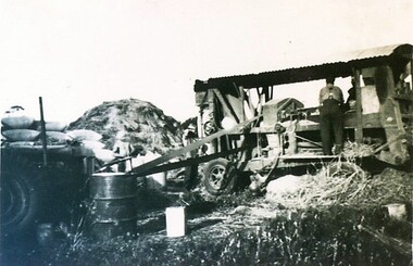
Photograph - Card Box Photographs, Chaff cutting, Millbrook 1939
... Chaff cutting, Millbrook 1939....Millbrook...City of Ballarat Libraries Eureka Centre Eureka Street Ballarat East goldfields Millbrook Farm Work Manufacturing Vehicle Chaff cutting, Millbrook 1939. ...millbrook, farm work, manufacturing, vehicle -
 City of Ballarat Libraries
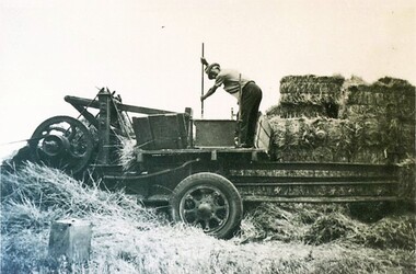
Photograph - Card Box Photographs, Pressing straw into wire tied bales, Millbrook 1939
... Pressing straw into wire tied bales, Millbrook 1939....City of Ballarat Libraries Eureka Centre Eureka Street Ballarat East goldfields Farm Work Vehicle Manufacturing Pressing straw into wire tied bales, Millbrook 1939. Photograph Card Box Photographs ...farm work, vehicle, manufacturing -
 City of Ballarat Libraries
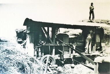
Photograph - Card Box Photographs, Chaff cutting, Millbrook 1939
... Chaff cutting, Millbrook 1939....City of Ballarat Libraries Eureka Centre Eureka Street Ballarat East goldfields Farm Work Vehicle Persons Chaff cutting, Millbrook 1939. Photograph Card Box Photographs ...farm work, vehicle, persons -
 City of Ballarat Libraries
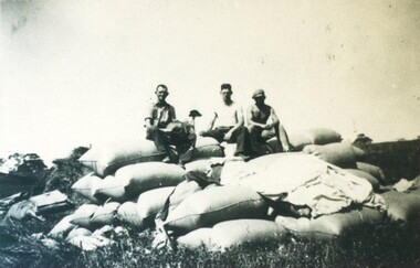
Photograph - Card Box Photographs, Agricultural workers on chaff filled bags 1939
... ...Millbrook...Jim Clancy, Sid Stewart and John Hunter sit of 'sleeping quarters' for workers on threshing machines on a farm at Millbrook....City of Ballarat Libraries Eureka Centre Eureka Street Ballarat East goldfields Jim Clancy, Sid Stewart and John Hunter sit of 'sleeping quarters' for workers on threshing machines on a farm at Millbrook. Jim Clancy Sid Stewart John Hunter Millbrook Farm Work Agriculture People Agricultural workers on chaff filled bags 1939. ...Jim Clancy, Sid Stewart and John Hunter sit of 'sleeping quarters' for workers on threshing machines on a farm at Millbrook.jim clancy, sid stewart, john hunter, millbrook, farm work, agriculture, people -
 Hume City Civic Collection
Photograph, Late 1980's
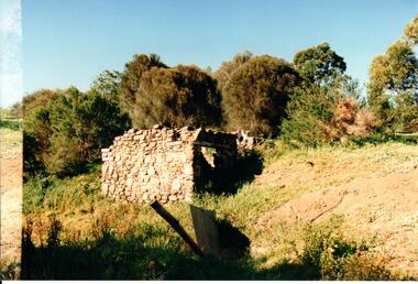
... The Millbrook ruins are on a property which was created by John Pascoe Fawkner's Victoria Co-operative Freehold Land Investment Society. ...Hume City Civic Collection 44 Macedon Street Sunbury melbourne The Millbrook ruins are on a property which was created by John Pascoe Fawkner's Victoria Co-operative Freehold Land Investment Society. ...The Millbrook ruins are on a property which was created by John Pascoe Fawkner's Victoria Co-operative Freehold Land Investment Society. The aims of the company were to provide smallholdings to poorer settlers who wanted to farm. The ruins are now part of the Organ Pipes Park.A coloured photograph of stone ruins built on a hillside with sheoaks and other vegetation behind it. There is a doorway at the end of the small building.fawkner, john pascoe, millbrook ruin, jacksons creek, organ pipes park, victorian co-operative freehold land investment society, george evans collection -
 Buninyong Visitor Information Centre
Document (item) - Information Folder, Sands and McDougall, Extracts from Sands and McDougall Directory of Victoria, 1939
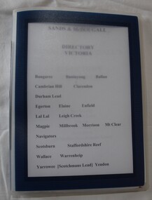
... Towns include Buninyong, Bungaree, Ballan, Cambrian Hill Clarendon, Durham Hill, Egerton, Elaine, Enfield, Lal Lal, Leigh Creek, Magpie, Millbrook, Morrisons, Mount Clear, Navigators, Scotsburn, Staffordshire Reef, Wallace, Warrenheip, Yarrowee (Scotchman's Lead), Yendon....Towns include Buninyong, Bungaree, Ballan, Cambrian Hill Clarendon, Durham Hill, Egerton, Elaine, Enfield, Lal Lal, Leigh Creek, Magpie, Millbrook, Morrisons, Mount Clear, Navigators, Scotsburn, Staffordshire Reef, Wallace, Warrenheip, Yarrowee (Scotchman's Lead), Yendon. ...Entries of resident's names and occupations in towns around the Shire of Buninyong. Towns include Buninyong, Bungaree, Ballan, Cambrian Hill Clarendon, Durham Hill, Egerton, Elaine, Enfield, Lal Lal, Leigh Creek, Magpie, Millbrook, Morrisons, Mount Clear, Navigators, Scotsburn, Staffordshire Reef, Wallace, Warrenheip, Yarrowee (Scotchman's Lead), Yendon.Individuals' names handwritten on the pages.directories, sands & mcdougall, buninyong, occupations -
 Ballan Shire Historical Society
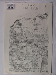
Map - Map. Shire of Ballan, Shire of Ballan
... ...millbrook...Ballan Shire Historical Society 45-47 Steiglitz St Ballan goldfields This is a fairly comprehensive map of the former Shire of Ballan which is now amalgamated into the Shire of Moorabool. gordon ballan bungal kerrit bareet borhoneyghurk bungeeltap ballark yaloak gorong beremboke wallace ingliston hunterston millbrook bradshaw myrniong blackwood moorarbool greendale bayup trentham bullarto korweinguboora glenlyon bolwarra A black and white map of the Shire of Ballan showing major roads, rivers, towns, settlements, State parks and forests and land subdivisions. ...This is a fairly comprehensive map of the former Shire of Ballan which is now amalgamated into the Shire of Moorabool.A black and white map of the Shire of Ballan showing major roads, rivers, towns, settlements, State parks and forests and land subdivisions. It appears to be a copy of the original as no dates or maker or printer appear on the map. There is a scale of 2 miles to 1 inch.gordon, ballan, bungal, kerrit bareet, borhoneyghurk, bungeeltap, ballark, yaloak, gorong, beremboke, wallace, ingliston, hunterston, millbrook, bradshaw, myrniong, blackwood, moorarbool, greendale, bayup, trentham, bullarto, korweinguboora, glenlyon, bolwarra -
 Federation University Historical Collection
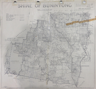
Map, Shire of Buninyong, c1970
... ...millbrook...Barker Library (top floor) Mount Helen goldfields The Shire of Buninyong was located on the southern side of Ballarat. shire of buninyong buninyong clarendon narmbool enfield lychfield scotchman's navigators warrenheip scotsburn mt doran durham lead cambrian hill napoleons garibaldi mt clear lal lal bonshaw state forest elaine elaine north cargerie grenville mt mercer millbrook wallace yendon canadian kaolin deposits Mount Helen Campus .1) B.I.A.E., St Martin's, cemetery, mt Buninyong, mt Innes, rly stn Two maps of the Shire of Buninyong. .1) Map showing the County divisions, township boundaries, Railway line, State Forest boundary, riding boundary and shire boundary. ...The Shire of Buninyong was located on the southern side of Ballarat.Two maps of the Shire of Buninyong. .1) Map showing the County divisions, township boundaries, Railway line, State Forest boundary, riding boundary and shire boundary. Identifying words have been added in red and green texta. .2) Shire of Buninyong Parish Plan. Includes Buninyong, Clarendon, Narmbool, Enfield, Lychfield, SCotchman's, Navigators, Warrenheip, Scotsburn, mr Doran, Durham Lead, Cambrian Hill, Napoleons, Garibaldi, Mt Clear, Lal Lal, Bonshaw.1) B.I.A.E., St Martin's, cemetery, mt Buninyong, mt Innes, rly stn shire of buninyong, buninyong, clarendon, narmbool, enfield, lychfield, scotchman's, navigators, warrenheip, scotsburn, mt doran, durham lead, cambrian hill, napoleons, garibaldi, mt clear, lal lal, bonshaw, state forest, elaine, elaine north, cargerie, grenville, mt mercer, millbrook, wallace, yendon, canadian, kaolin deposits, mount helen campus -
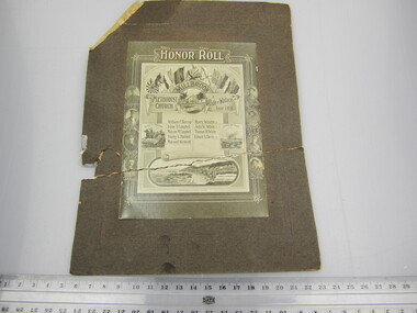 Ballarat RSL Sub-Branch Inc.
Photograph - Millbrook Methodist Church & Pride of Wallace Tent I.O.R. Honour Roll
... Ballarat RSL Sub-Branch Inc. 330 Heinz Lane Invermay Park goldfields Photo/Pictures Ballarat RSL Ballarat With portraits and names of - William C BURRUP Irvine T CAMPBELL Malcolm M CAMPBELL Stanley G HALFORD Maynard WESTCOTT Harry WRIGHT KIA John W WHITE KIA Thomas H WHITE KIA Edward A HARRIS KIA Photograph - Millbrook Methodist Church & Pride of Wallace Tent I.O.R. ...With portraits and names of - William C BURRUP Irvine T CAMPBELL Malcolm M CAMPBELL Stanley G HALFORD Maynard WESTCOTT Harry WRIGHT KIA John W WHITE KIA Thomas H WHITE KIA Edward A HARRIS KIAphoto/pictures, ballarat rsl, ballarat