Showing 74 items matching "mines sea mines"
-
 Running Rabbits Military Museum operated by the Upwey Belgrave RSL Sub Branch
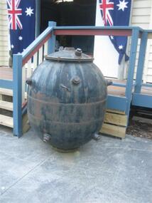
World War 2 Era Contact Sea Mine
... mines sea mines...These mines were tethered to the sea bed and were detonated when a ship came into contact with the "Horns" that protruded from the mines exterior surface (removed in this example although the fixing points are clearly visible.) The mines...mine carried enough exlposive to sink even the largest of ships. Floating mines typically have a mass of around 200 kg,including 80 kg of explosives e.g. TNT, Minol or Amatol. mines sea ...These mines were tethered to the sea bed and were detonated when a ship came into contact with the "Horns" that protruded from the mines exterior surface (removed in this example although the fixing points are clearly visible.) The mines were usually laid by ships or submarines in "Fields" across harbour entrances or in busy shipping lanes. They were tethered so that they floated several feet below the water. This type of mine carried enough exlposive to sink even the largest of ships. Floating mines typically have a mass of around 200 kg,including 80 kg of explosives e.g. TNT, Minol or Amatol.mines sea mines -
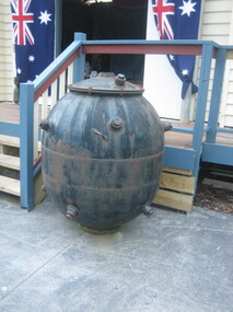
 Bendigo Military Museum
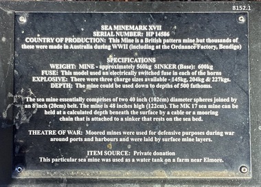
Weapon - SEA MINE, MARK XV11, 1939 - 45
... mine is situated in the gardens of the Bendigo District RSL Sub Branch Inc Havilah Road Bendigo. Refer photo .1) re details of manufacture and its history/use. brsl smirsl bdrslinc sea mine Refer .1) plaque. .1) Plaque on black metal stand with white text with details re the mine. 2) Mine slightly oval shape, black with a white band, the top has a bolted on section as a lid, there are multiple "horns" attached around the mine. ...This mine is situated in the gardens of the Bendigo District RSL Sub Branch Inc Havilah Road Bendigo. Refer photo .1) re details of manufacture and its history/use..1) Plaque on black metal stand with white text with details re the mine. 2) Mine slightly oval shape, black with a white band, the top has a bolted on section as a lid, there are multiple "horns" attached around the mine.Refer .1) plaque.brsl, smirsl, bdrslinc, sea mine -
 4th/19th Prince of Wales's Light Horse Regiment Unit History Room
Medal, Naval General Service Medal 1915-62
... These are: Persian Gulf 1909-1914 Iraq 1919-1920 NW Persia 1919-1920 NW Persia 1920 Palestine 1936-1939 SE Asia 1945-46 Minesweeping 1945-51 Palestine 1945-48 Bomb and Mine Clearance 1945-53 Malaya Yangtze 1949 Bomb and Mine Clearance, Mediterranean Cyprus Near East Arabian Peninsula Brunei Medal Naval General Service Medal The NGSM 1915-62 is cupro-nickel medal with the obverse having the effigy of the reigning sovereign at time of issue. The reverse bears an image of ‘Britannia' in a chariot pulled by two sea ...The Naval General Service Medal (NGSM) was instituted in 1915 for service in minor Naval war-like operations. As is the case with other ‘general service' medals the NGSM is always issued with a clasp denoting the area of operations. Subsequent service is recognised by the award of further clasps to be worn on the original medal. Members mentioned in despatches for operations recognised by the NGSM 1915-1962 after 11 Aug 1920 were approved to wear a bronze oak leaf on the medal ribbon. Clasps There have been sixteen clasps issued for the NGSM 1915-1962. These are: Persian Gulf 1909-1914 Iraq 1919-1920 NW Persia 1919-1920 NW Persia 1920 Palestine 1936-1939 SE Asia 1945-46 Minesweeping 1945-51 Palestine 1945-48 Bomb and Mine Clearance 1945-53 Malaya Yangtze 1949 Bomb and Mine Clearance, Mediterranean Cyprus Near East Arabian Peninsula Brunei Medal The NGSM 1915-62 is cupro-nickel medal with the obverse having the effigy of the reigning sovereign at time of issue. The reverse bears an image of ‘Britannia' in a chariot pulled by two sea-horses. The NGSM 1915-62 ribbon has a wide white central stripe, flanked by two red pin-stripes, further flanked by two white stripes, which in turn are flanked by two red outer stripes.naval general service medal -
 Bendigo Historical Society Inc.
Document - LONG GULLY HISTORY GROUP COLLECTION: GUIDE TO SOME FAMOUS MINES
... mine's location, depth of shaft, poppet legs, machinery, location of engine house, gold yield, dividends and owners of mine. The mines are: The New Chum Line of Reef. The New Chum Railway, Kochs Pioneer, Windmill Hill, Confidence Extended, Johnson's No 1, Johnson's No2, Johnson's No 3, North Johnson's, Princess Dagmar, Golden Age, Johnson's Reef Extended, Golden Pyke, Constellation, Great Northern, Virginia, Specimen Hill United, New Argus, Clarence United, North Argus, South New Moon, New Chum Hill, The New Chum and Victoria, Catherine Reef United. Garden Gully Line of Reefs. The Great Southern, Ulster United, Londonderry, South Garden, The Sea...mine's location, depth of shaft, poppet legs, machinery, location of engine house, gold yield, dividends and owners of mine. The mines are: The New Chum Line of Reef. The New Chum Railway, Kochs Pioneer, Windmill Hill, Confidence Extended, Johnson's No 1, Johnson's No2, Johnson's No 3, North Johnson's, Princess Dagmar, Golden Age, Johnson's Reef Extended, Golden Pyke, Constellation, Great Northern, Virginia, Specimen Hill United, New Argus, Clarence United, North Argus, South New Moon, New Chum Hill, The New Chum and Victoria, Catherine Reef United. Garden Gully Line of Reefs. The Great Southern, Ulster United, Londonderry, South Garden, The Sea ...Three pages titled Guide to Some Famous Mines. Compiled by A Richardson. Each mine is listed as on the reef it is situated on. Reefs are The New Chum Line of Reef and the Garden Gully Line of Reefs, and the Devonshire Group. Mentioned is the mine's location, depth of shaft, poppet legs, machinery, location of engine house, gold yield, dividends and owners of mine. The mines are: The New Chum Line of Reef. The New Chum Railway, Kochs Pioneer, Windmill Hill, Confidence Extended, Johnson's No 1, Johnson's No2, Johnson's No 3, North Johnson's, Princess Dagmar, Golden Age, Johnson's Reef Extended, Golden Pyke, Constellation, Great Northern, Virginia, Specimen Hill United, New Argus, Clarence United, North Argus, South New Moon, New Chum Hill, The New Chum and Victoria, Catherine Reef United. Garden Gully Line of Reefs. The Great Southern, Ulster United, Londonderry, South Garden, The Sea Amalgamated, Garden Gully United, Victory and Pandora, Unity Mine, Carlisle United, Cornish United, Eureka Extended, South Belle Vue United, Shenandoah, Shamrock, New Chum Consolidated, New Chum United, Lansell's 222, Rae's Open Cut, Great Central Victoria, Victoria Consols, The Ironbark, Hercules and Energetic, Pearl, The Devonshire Group. North of Staley,The Duke of Edinburgh, New St Mungo, Duchess Tribute, South Devonshire, Duchess of Edinburgh, Princess Alexandra, West United Devonshire, Hopewell, Phoenix. Yhe Mungo Mines. Unicorn, South St Mungo, Lady Barkly, The St Mungo, Sadowa, Eastwood. Snobs Hill Group. The Ellenborough, The Belmont and Saxby, York and Durham, The Acadia, William's United, The Victoria Hill - Ironbark, The North Old Chum, Lansell's Big 180, Ballerstadt's Open-Cut and The Victoria Quartz.bendigo, history, long gully history group, the long gully history group - guide to some famous mines, a richardson, the new chum railway, kochs pioneer, windmill hill, confidence extended, johnson's no 1, johnson's no2, johnson's no 3, north johnson's, princess dagmar, golden age, johnson's reef extended, golden pyke, constellation, great northern, virginia, specimen hill united, new argus, clarence united, north argus, south new moon, new chum hill, the new chum and victoria, catherine reef united, the great southern, ulster united, londonderry, south garden, the sea amalgamated, garden gully united, victory and pandora, unity mine, carlisle united, cornish united, eureka extended, south belle vue united, shenandoah, shamrock, new chum consolidated, new chum united, lansell's 222, rae's open cut, great central victoria, victoria consols, the ironbark, hercules and energetic, pearl, the duke of edinburgh, new st mungo, duchess tribute, south devonshire, duchess of edinburgh, princess alexandra, west united devonshire, hopewell, phoenix, unicorn, south st mungo, lady barkly, the st mungo, sadowa, eastwood, the ellenborough, the belmont and saxby, york and durham, the acadia, william's united, the victoria hill - ironbark, the north old chum, lansell's big 180, ballerstadt's open-cut, the victoria quartz -
 Bendigo Historical Society Inc.
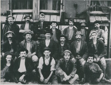
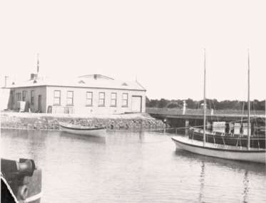
Photograph - SEA MINE: GARDEN GULLY LINE
... black and white photo : 18 men ( boys ) in front of mine , dressed in working clothes. 3 rows of males, building at back has 3 stoping chutes with timber boards, structure appears to be off the ground 4 - 5 feet. . ' On Back "Sea ' Mine...History House 11 Mackenzie Street Bendigo goldfields ORGANIZATION Business sea mine garden gully line black and white photo : 18 men ( boys ) in front of mine , dressed in working clothes. 3 rows of males, building at back has 3 stoping chutes with timber boards, structure appears to be off the ground 4 - 5 feet. . ' On Back "Sea ' Mine , Garden Gully Line ' . : A. ...black and white photo : 18 men ( boys ) in front of mine , dressed in working clothes. 3 rows of males, building at back has 3 stoping chutes with timber boards, structure appears to be off the ground 4 - 5 feet. . ' On Back "Sea ' Mine , Garden Gully Line ' . : A. Richardson , 29 Harrison St., Bendigoorganization, business, sea mine, garden gully line -
 Bendigo Historical Society Inc.
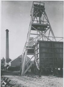
Photograph - SEA MINE: GARDEN GULLY LINE BENDIGO, 1960
... mine site. Male figure at the base of poppet head. on back Sea Mine Garden Gully Line Bendigo....History House 11 Mackenzie Street Bendigo goldfields ORGANIZATION Business sea mine garden gully line black and white photograph : poppet head and chimney stack and boilers of mine site. ...black and white photograph : poppet head and chimney stack and boilers of mine site. Male figure at the base of poppet head. on back Sea Mine Garden Gully Line Bendigo.organization, business, sea mine, garden gully line -
Phillip Island and District Historical Society Inc.
Sketch, 1890
... Mine. A landscape - sea and cliffs in the background. A small shed with chimney beside poppet head. Track winding down to three miners. Wooden sheds, all with chimneys. In Foreground a picket fence on cliff on right of picture. A small tree stump on left. Local History PHOTOGRAPHY Photographs Slides Film Kilcunda Mine Black & white pen and ink Sketch Miss Elms San Remo James Stirling Cape Paterson Shaft - Kilcunda The Kilcunda Mine Sketch ...The Cape Paterson shaft at Kilcunda Mine. A landscape - sea and cliffs in the background. A small shed with chimney beside poppet head. Track winding down to three miners. Wooden sheds, all with chimneys. In Foreground a picket fence on cliff on right of picture. A small tree stump on left.The Kilcunda MineCape Paterson Shaft - Kilcundalocal history, photography, photographs, slides, film, kilcunda mine, black & white, pen and ink sketch, miss elms san remo, james stirling -
 Running Rabbits Military Museum operated by the Upwey Belgrave RSL Sub Branch
Sea Mine
... Running Rabbits Military Museum operated by the Upwey Belgrave RSL Sub Branch 1 Mast Gully Road Upwey melbourne Sea Mine Sea Mine ...Sea Mine -
 Bendigo Historical Society Inc.
Document - LONG GULLY HISTORY GROUP COLLECTION: EDWARD CLARENCE DYASON
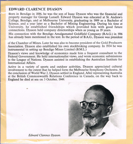
... sea on 3 October 1949. BENDIGO History long gully history group The Long Gully History Group - Edward Clarence Dyason Isaac Dyason George Lansell St Andrew's College Bendigo Melbourne University Bendigo Amalgamated Goldfield Company (B. A. G.) Chamber of Mines Gold Producers Association Bendigo Mines ...Edward Clarence Dyason was born in Bendigo in 1886, the son of Isaac Dyason who was the financial and property manager for George Lansell. After World Was 2, he settled in England. He represented Australia at the British Commonwealth Relations Conference in Canada, on the way back to England he died at sea on 3 October 1949. Printed obituary with black and white photo of Edward Clarence Dyason. Printed article mounted on yellow card which is mounted on purple card and laminated.bendigo, history, long gully history group, the long gully history group - edward clarence dyason, isaac dyason, george lansell, st andrew's college bendigo, melbourne university, bendigo amalgamated goldfield company (b. a. g.), chamber of mines, gold producers association, bendigo mines limited (b.m.l.), league of nations, australian institute for international affairs, melbourne symphony orchestra, british commonwealth relations conference -
 Bendigo Historical Society Inc.
Document - ALBERT RICHARDSON COLLECTION: EARLY HISTORY OF THE BENDIGO GOLDFIELD
... mines department Typed foolscap two sided document with information about the early history of the Bendigo Goldfield. Topics include the first gold discovery, how gullies were worked, quartz reefing, gold cakes, hand dollies and Chilian mills. Some brief statistics of the Bendigo goldfield include the total gold yield of 17,370,561 ounces plus 5,000,000 oz sold outside Bendigo. The greatest depth reached by any mine in the State, 4,593 feet below surface, or 3,700 feet below sea ...Typed foolscap two sided document with information about the early history of the Bendigo Goldfield. Topics include the first gold discovery, how gullies were worked, quartz reefing, gold cakes, hand dollies and Chilian mills. Some brief statistics of the Bendigo goldfield include the total gold yield of 17,370,561 ounces plus 5,000,000 oz sold outside Bendigo. The greatest depth reached by any mine in the State, 4,593 feet below surface, or 3,700 feet below sea-level, was attained by the Victoria Quartz Company. About 100 shafts exceed a depth of 1,000 feet, of which 40 are between 2,000 and 3,000 feet deep, fifteen are between 3,000 and 4,000 feet and two are over 4,000 feet.bendigo, mining, mines department -
 Bendigo Historical Society Inc.
Document - ALBERT RICHARDSON COLLECTION: SECRETARY FOR MINES ANNUAL REPORT 1911
... Longitudinal sections along the lines of reefs or anticlines within the 8 mile block at Bendigo are shown in a diagram' (diagram not included with notes) Mines and reef lines mentioned in the report are : New Chum line, New Chum Railway mine, Catherine United mine, Hercules and Energetic mine, Garden Gully, Hustlers and Redan, Sheepshead Reef, Sea Mine, Garden Gully, Miller's line of reef and Bendigo Development Mine. ...Longitudinal sections along the lines of reefs or anticlines within the 8 mile block at Bendigo are shown in a diagram' (diagram not included with notes) Mines and reef lines mentioned in the report are : New Chum line, New Chum Railway mine, Catherine United mine, Hercules and Energetic mine, Garden Gully, Hustlers and Redan, Sheepshead Reef, Sea Mine, Garden Gully, Miller's line of reef and Bendigo Development Mine. ...Three page typed report titled ' Notes on diagram showing pitch lines, Bendigo'. Longitudinal sections along the lines of reefs or anticlines within the 8 mile block at Bendigo are shown in a diagram' (diagram not included with notes) Mines and reef lines mentioned in the report are : New Chum line, New Chum Railway mine, Catherine United mine, Hercules and Energetic mine, Garden Gully, Hustlers and Redan, Sheepshead Reef, Sea Mine, Garden Gully, Miller's line of reef and Bendigo Development Mine. The 'old stacks' or chimneys, on Bendigo are described. 'Among the earliest of the stacks built at Bendigo in connexion with Quartz crushing plant, are the two figured in this Annual report No 1 was situate in Sailor's Gully but was demolished about three years ago. This, if not the first, must have been one of the first built, for it had a stone inserted on which chiselled the date 1854. It was built altogether of rough masonry. The other, No. 2, is still standing at the Sheepshead line and was apparently of later date, the upper portion being of brick. They are intersting landmarks of an era that is rapidly passing.' Map attached to report showing location of stacks. Stack at Sailors Gully was near the corner of Murchison Street and Lester Street. The stack at Sheepshead ( Deborah Triangle area) was near the intersection of Belle Vue Road and Adam Street.bendigo, mining, pitch lines bendigo -
 Bendigo Historical Society Inc.
Document - GARDEN GULLY LINE OF REEF, LEASE BLOCKS 5360 AND 5361
... Mines 1899. The area described is about 'one mile and a quarter southeast from the centre of the city of Bendigo, immediately south of the Great Southern Gold Mining Company's workings and is intersected by two auriferous gullies ... Salomon's Gully and Derwenter's Gully'. The alluvial deposits, the Garden Gully line, the Great Souther Co.and old workings are discussed in the paper. A map of the Garden Gully line of reef is attached to the report, showing claimholders and mine names along that section of the reef. Mines named on the map: Great Southern Garden Gully United Ulster Londonderry Burrows Horwoods Sea...Mines 1899. The area described is about 'one mile and a quarter southeast from the centre of the city of Bendigo, immediately south of the Great Southern Gold Mining Company's workings and is intersected by two auriferous gullies ... Salomon's Gully and Derwenter's Gully'. The alluvial deposits, the Garden Gully line, the Great Souther Co.and old workings are discussed in the paper. A map of the Garden Gully line of reef is attached to the report, showing claimholders and mine names along that section of the reef. Mines named on the map: Great Southern Garden Gully United Ulster Londonderry Burrows Horwoods Sea ...Two page document titled ' Report on lease blocks Nos. 5360 and 5361 Garden Gully line of reef, Bendigo. Produced by the Department of Mines 1899. The area described is about 'one mile and a quarter southeast from the centre of the city of Bendigo, immediately south of the Great Southern Gold Mining Company's workings and is intersected by two auriferous gullies ... Salomon's Gully and Derwenter's Gully'. The alluvial deposits, the Garden Gully line, the Great Souther Co.and old workings are discussed in the paper. A map of the Garden Gully line of reef is attached to the report, showing claimholders and mine names along that section of the reef. Mines named on the map: Great Southern Garden Gully United Ulster Londonderry Burrows Horwoods Sea Amalgamated Garden Gully United Victory and Pandora Unity Carlisle and Garden Gully and Passbye United Cornish United Koch's PioneerJames Stirling, Government Geologistbendigo, mining, garden gully line of reef mines -
 Bendigo Historical Society Inc.
Document - GARDEN GULLY LINE OF REEF
... 'The Garden Gully line of reef, south to north, main shafts only' Great Southern, first important mine 1876 - 1924 Ulster United Londonderry shaft The Sea Amalgamated Garden Gully United 'Bendigo's most famous mine' 1874 - 1921 Victory and Pandora Ironbark 1871 - 1921 Unity Mine Carlisle United Long Gully ' Bendigo's richest mine' Cornish United 1866 - 1920 Koch's pioneer Windmill Hill 1874 - 1920 Confidence Extended 1877 - 1896 - 1915 Johnson's Group California Gully No. 1 and No. 2 and No. 3 Derby line North Johnson's Princess Dagmar 1876 - 1918 Golden Age 1870 - 1917 Johnson's Reef Extended Golden Pyke 1870 - 1921 Constellation 1887 - 1923 Great Northern 1877 - 1922 Virginia 1878 - 1922 Specimen Hill United 1860 - 1920 New Argus 1864 - 1922 Clarence United Sailors Gully 1857 - 1918 South New Moon 1871-1920's and 1933 - 1941 New Moon 1868 - 1922 - 1931 Suffolk United 1870 - 1918 North New Moon 1894 - 1924...mines Albert Richardson Handwritten document . 'The Garden Gully line of reef, south to north, main shafts only' Great Southern, first important mine 1876 - 1924 Ulster United Londonderry shaft The Sea Amalgamated Garden Gully United 'Bendigo's most famous mine' 1874 - 1921 Victory and Pandora Ironbark 1871 - 1921 Unity Mine Carlisle United Long Gully ' Bendigo's richest mine' Cornish United 1866 - 1920 Koch's pioneer Windmill Hill 1874 - 1920 Confidence Extended 1877 - 1896 - 1915 Johnson's Group California Gully No. 1 and No. 2 and No. 3 Derby line North Johnson's Princess Dagmar 1876 - 1918 Golden Age 1870 - 1917 Johnson's Reef Extended Golden Pyke 1870 - 1921 Constellation 1887 - 1923 Great Northern 1877 - 1922 Virginia 1878 - 1922 Specimen Hill United 1860 - 1920 New Argus 1864 - 1922 Clarence United Sailors Gully 1857 - 1918 South New Moon 1871-1920's and 1933 - 1941 New Moon 1868 - 1922 - 1931 Suffolk United 1870 - 1918 North New Moon 1894 - 1924 Document GARDEN GULLY LINE OF REEF ...Handwritten document . 'The Garden Gully line of reef, south to north, main shafts only' Great Southern, first important mine 1876 - 1924 Ulster United Londonderry shaft The Sea Amalgamated Garden Gully United 'Bendigo's most famous mine' 1874 - 1921 Victory and Pandora Ironbark 1871 - 1921 Unity Mine Carlisle United Long Gully ' Bendigo's richest mine' Cornish United 1866 - 1920 Koch's pioneer Windmill Hill 1874 - 1920 Confidence Extended 1877 - 1896 - 1915 Johnson's Group California Gully No. 1 and No. 2 and No. 3 Derby line North Johnson's Princess Dagmar 1876 - 1918 Golden Age 1870 - 1917 Johnson's Reef Extended Golden Pyke 1870 - 1921 Constellation 1887 - 1923 Great Northern 1877 - 1922 Virginia 1878 - 1922 Specimen Hill United 1860 - 1920 New Argus 1864 - 1922 Clarence United Sailors Gully 1857 - 1918 South New Moon 1871-1920's and 1933 - 1941 New Moon 1868 - 1922 - 1931 Suffolk United 1870 - 1918 North New Moon 1894 - 1924Albert Richardsonbendigo, mining, garden gully line of reef mines -
Bendigo Historical Society Inc.
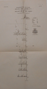
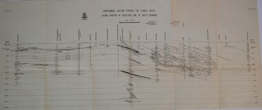
Map - SECTIONS ACROSS BENDIGO GOLDFIELD
... mines along the reef lines. Key shows rock types Castlemaine, Bendigo B1, B2, B3 and B4, and Lancefieldian. First part of map shows sections A-A, B-B and C-C. Reef lines drawn with mines listed: Fault line shown are the Carshalton, Stafford, New Chum, Virginia and Clarence. A datum line shows 600 ft above sea...mines along the reef lines. Key shows rock types Castlemaine, Bendigo B1, B2, B3 and B4, and Lancefieldian. First part of map shows sections A-A, B-B and C-C. Reef lines drawn with mines listed: Fault line shown are the Carshalton, Stafford, New Chum, Virginia and Clarence. A datum line shows 600 ft above sea ...Map in three sections showing sections across Bendigo Gold Field, showing anticlines, synclines, faults, stratigraphical zones and mines along the reef lines. Key shows rock types Castlemaine, Bendigo B1, B2, B3 and B4, and Lancefieldian. First part of map shows sections A-A, B-B and C-C. Reef lines drawn with mines listed: Fault line shown are the Carshalton, Stafford, New Chum, Virginia and Clarence. A datum line shows 600 ft above sea level. On bottom of plan: ' Prepared in the Geological Survey Office, Bendigo, under the direction of H. Herman, late Director of Geological Survey, from surveys by H.S. Whitelaw, Field Geologist, assisted by E.S. Usher, A.J.J. Moore and R.A. Keble.' Second section of map shows sections D-D, and E-E. Fault lines listed are the Tambour Major fault, Carshalton fault, Stafford fault, Nell Gwynne fault, New Chum fault, Deborah fault. Third section shows sections F-F and G-G. Fault lines listed are the Bird Reef fault, Kangaroo Gully fault, Langdon fault, Carshalton fault, Nell Gwynne fault, Spring Gully fault, Hustlers fault, Gravel Hill fault, Ordes fault, Thanet fault. This map forms part of the Geological Survey of Victoria, Structure of Bendigo Goldfield report, No. 47, 1923. H.Herman, late Director of Geological Survey.Geological Survey of Victoriabendigo, gold mining, reef line maps -
 Queenscliffe Maritime Museum
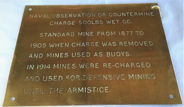
Plaque - Plaque, brass inscribed with Naval countermine information
... mines (known as electric torpedo) and ships to defend the entrance to Port Phillip Bay. Swan Island Fort would be used to protect the minefields in the harbour, Naval observation countermine charge 500lbs wet G.C Standard mine from 1877 to 1905 when charge was removed and mines used as buoys. In 1914 mines were recharged and used for defensive mining until Armistice. Sea ...Found in garden shed of Mr Harry Barratt [WWI Gallipoli] and donated by his grandson. In 1877 Swan island was designed to defend shipping in Port Phillip and Hobson's Bays. The scheme, involving massive expenditure, comprised a forward defence system of forts at Port Phillip heads dominated by Fort Queenscliff and South Channel Fort (artificial island), and a network of coastal batteries. Some development of fortification had occurred in the 1850s, but it was the impetus of the Jervois-Scratchley reports which led to major work being undertaken in the 1880s. The overall defence plan involved a combination of guns, mines (known as electric torpedo) and ships to defend the entrance to Port Phillip Bay. Swan Island Fort would be used to protect the minefields in the harbour, Naval observation countermine charge 500lbs wet G.C Standard mine from 1877 to 1905 when charge was removed and mines used as buoys. In 1914 mines were recharged and used for defensive mining until Armistice.Brass plaque inscribed with information on naval countermineNaval observation or countermine charge 500lbs wet G.C. Standard mine from 1877 to 1905 when charge was removed and mines used as buoys. In 1914 mines were recharged and used for defensive mining until the Armistice.sea mine, plaque, pre wwi, naval countermine, swan island -
 Queenscliffe Maritime Museum
Photograph - B&W photo c1900 of Navy Mines & Layers depot Swan Island, Swan Is. Mines Depot c1900, c1900
... Queenscliffe Maritime Museum 2 Wharf St Queenscliff geelong-and-the-bellarine-peninsula Mine storage Mine storage facility on Swan Island. c1900 History Reverse " Naval dock Swan Island 1900 / a safe harbour for fishing boats (with permit) when high seas & strong winds makes when dangerous in usual anchorage / the boats are naval training sailing cutters (with oars)/ there were 2 jetties (one on RH side of the photo) and on the end of one was a cookhouse in bottom LH, a boat moored at the southern jetty (possibly VULCAN a general purpose tug of Navy.) " B&W photo Swan Island Navy Mines & Layers Depot c1900. ...Mine storageMine storage facility on Swan Island. c1900B&W photo Swan Island Navy Mines & Layers Depot c1900.Reverse " Naval dock Swan Island 1900 / a safe harbour for fishing boats (with permit) when high seas & strong winds makes when dangerous in usual anchorage / the boats are naval training sailing cutters (with oars)/ there were 2 jetties (one on RH side of the photo) and on the end of one was a cookhouse in bottom LH, a boat moored at the southern jetty (possibly VULCAN a general purpose tug of Navy.) "history -
 Bendigo Historical Society Inc.
Document - BENDIGO MINES 1906
... Mines. Four mines, Garden Gully United, South New Moon, Hustlers Reef and Catherine Reef United have some information about them. Others listed are: Catherine Reef United, Carlisle, Clarence United, Central Ellesmere, Collman & Tacchi, Confidence Extended Cornish United, Ellenborough, Extd South Devonshire, Eureka, Fortuna Hustlers, Garden Gully United, G G Consolidated, Geribaldi, Great Southern, Gt Northern, Gt Extended Hustlers, Gt Central Victoria, Golden Age, Golden Pyke, Goldfields North, Goldfields Consolidated, North Johnsons, Pearl, Princess Dagmar, Phoenix, Railway Prince of Wales, Shamrock, St Mungo, Sadowa, Sea, Specimen Hill Sth St Mungo, South New Moon, South Devonshire, Suffolk United, United Devonshire, Unity, United Hustlers & Redan, United Ulster, Victoria Consols, Victoria Quartz, Pansora, Virginia, Victoria Proprietory, Williams United, Hustlers Reef, Hustlers Royal Reserve, Hercules & Energetic, Ironbark, Johnsons Reef No 1, Hustlers Royal Reserve, Ironbark, Johnsons Reef, Johnsons Extended, Kochs Pioneer, Lazarus New Chum, Lady Barkly - Lightning Hill, McDuff Amalgamated, Morning Star, New Chum Consolidated, New Chum Railway, New Chum & Victoria, New Blue Consolidated, New Hopefu, New St Mungo, New Argus, New Moon, New Victoria Catherine, New Chum Goldfields, North New Moon and North Argus. ...History House 11 Mackenzie Street Bendigo goldfields DOCUMENT Gold bendigo mines 1906 Bendigo Mines 1906 Catherine Reef United Carlisle Clarence United Central Ellesmere Collman & Tacchi Confidence Extended Cornish United Ellenborough Extd South Devonshire Eureka Fortuna Hustlers Garden Gully United G G Consolidated Geribaldi Great Southern Gt Northern Gt Extended Hustlers Gt Central Victoria Golden Age Golden Pyke Goldfields North Goldfields Consolidated North Johnsons Pearl Princess Dagmar Phoenix Railway Prince of Wales Shamrock St Mungo Sadowa Sea Specimen Hill Sth St Mungo South New Moon South Devonshire Suffolk United United Devonshire Unity United Hustlers & Redan United Ulster Victoria Consols Victoria Quartz Pansora Virginia Victoria Proprietory Williams United Hustlers Reef Hustlers Royal Reserve Hercules & Energetic Ironbark Johnsons Reef No 1 Hustlers Royal Reserve Ironbark Johnsons Reef Johnsons Extended Kochs Pioneer Lazarus New Chum Lady Barkly - Lightning Hill McDuff Amalgamated Morning Star New Chum Consolidated New Chum Railway New Chum & Victoria New Blue Consolidated New Hopefu New St Mungo New Argus New Moon New Victoria Catherine New Chum Goldfields North New Moon North Argus Bgo Library 'Healthy Golden Bendigo' - 1906 Handwritten notes mentioning Bendigo Mines. ...Handwritten notes mentioning Bendigo Mines. Four mines, Garden Gully United, South New Moon, Hustlers Reef and Catherine Reef United have some information about them. Others listed are: Catherine Reef United, Carlisle, Clarence United, Central Ellesmere, Collman & Tacchi, Confidence Extended Cornish United, Ellenborough, Extd South Devonshire, Eureka, Fortuna Hustlers, Garden Gully United, G G Consolidated, Geribaldi, Great Southern, Gt Northern, Gt Extended Hustlers, Gt Central Victoria, Golden Age, Golden Pyke, Goldfields North, Goldfields Consolidated, North Johnsons, Pearl, Princess Dagmar, Phoenix, Railway Prince of Wales, Shamrock, St Mungo, Sadowa, Sea, Specimen Hill Sth St Mungo, South New Moon, South Devonshire, Suffolk United, United Devonshire, Unity, United Hustlers & Redan, United Ulster, Victoria Consols, Victoria Quartz, Pansora, Virginia, Victoria Proprietory, Williams United, Hustlers Reef, Hustlers Royal Reserve, Hercules & Energetic, Ironbark, Johnsons Reef No 1, Hustlers Royal Reserve, Ironbark, Johnsons Reef, Johnsons Extended, Kochs Pioneer, Lazarus New Chum, Lady Barkly - Lightning Hill, McDuff Amalgamated, Morning Star, New Chum Consolidated, New Chum Railway, New Chum & Victoria, New Blue Consolidated, New Hopefu, New St Mungo, New Argus, New Moon, New Victoria Catherine, New Chum Goldfields, North New Moon and North Argus. Document from Albert Richardson Collection of mining history.document, gold, bendigo mines 1906, bendigo mines 1906, catherine reef united, carlisle, clarence united, central ellesmere, collman & tacchi, confidence extended cornish united, ellenborough, extd south devonshire, eureka, fortuna hustlers, garden gully united, g g consolidated, geribaldi, great southern, gt northern, gt extended hustlers, gt central victoria, golden age, golden pyke, goldfields north, goldfields consolidated, north johnsons, pearl, princess dagmar, phoenix, railway prince of wales, shamrock, st mungo, sadowa, sea, specimen hill sth st mungo, south new moon, south devonshire, suffolk united, united devonshire, unity, united hustlers & redan, united ulster, victoria consols, victoria quartz, pansora, virginia, victoria proprietory, williams united, hustlers reef, hustlers royal reserve, hercules & energetic, ironbark, johnsons reef no 1, hustlers royal reserve, ironbark, johnsons reef, johnsons extended, kochs pioneer, lazarus new chum, lady barkly - lightning hill, mcduff amalgamated, morning star, new chum consolidated, new chum railway, new chum & victoria, new blue consolidated, new hopefu, new st mungo, new argus, new moon, new victoria catherine, new chum goldfields, north new moon, north argus, bgo library 'healthy golden bendigo' - 1906 -
 Bendigo Historical Society Inc.
Document - NEW CHUM & VICTORIA LINES OF REEF - NOTES ON JOHNSON'S REEF
... Handwritten notes mention 'History of Bendigo by G Mackay, St Mungo Line of Reef from the Belmont Mine, Princess Alexander Shaft, Johnson's no 1 Mine, North Johnson's with notes on buildings, etc. and date 22/9/1892, and the Johnson's Reef Extended dated 29/10/1892, with note on building, mullock heap, and sill 779.18 above sea level. ...History House 11 Mackenzie Street Bendigo goldfields DOCUMENT Gold New Chum & Victoria Lines of Reef Notes on Johnson's Reef History of Bendigo G Mackay Mines' Dept St Mungo Line of Reef E J Dunn Report 21/10/92 Princess Alexander Shaft United Devonshire Shaft Johnson's Reef Garden Gully Line Johnson's No 1 Mine North Johnson's E J Dunn's report 29/10/1892 Johnson's reef Extended Leo Chapman Tom Sayers Handwritten notes mention 'History of Bendigo by G Mackay, St Mungo Line of Reef from the Belmont Mine, Princess Alexander Shaft, Johnson's no 1 Mine, North Johnson's with notes on buildings, etc. and date 22/9/1892, and the Johnson's Reef Extended dated 29/10/1892, with note on building, mullock heap, and sill 779.18 above sea level. ...Handwritten notes mention 'History of Bendigo by G Mackay, St Mungo Line of Reef from the Belmont Mine, Princess Alexander Shaft, Johnson's no 1 Mine, North Johnson's with notes on buildings, etc. and date 22/9/1892, and the Johnson's Reef Extended dated 29/10/1892, with note on building, mullock heap, and sill 779.18 above sea level. Also mentioned are Leo Chapman and Tom Sayers.document, gold, new chum & victoria lines of reef, notes on johnson's reef, history of bendigo, g mackay, mines' dept, st mungo line of reef, e j dunn report 21/10/92, princess alexander shaft, united devonshire shaft, johnson's reef, garden gully line, johnson's no 1 mine, north johnson's, e j dunn's report 29/10/1892, johnson's reef extended, leo chapman, tom sayers -
 Bendigo Historical Society Inc.
Map - HUSTLER'S ROYAL RESERVE NO 2 CO - TRANSVERSE SECTION OF THE HUSTLER'S ROYAL RESERVE NO 2 CO
... Mine on the Hustler's Line of Reef Bendigo, Bulletin No 33, Plate No VII. Section shows the poppet legs and the sill of Shaft at 707.65 ft above sea level, depth of levels, stone encountered and geological features. Geological Survey of Victoria emblem. H. Herman Director, W. Dickson Secretary of Mines and The Hon. J. Drysdale Brown MLC, Minister of Mines...Mine on the Hustler's Line of Reef Bendigo, Bulletin No 33, Plate No VII. Section shows the poppet legs and the sill of Shaft at 707.65 ft above sea level, depth of levels, stone encountered and geological features. Geological Survey of Victoria emblem. H. Herman Director, W. Dickson Secretary of Mines and The Hon. J. Drysdale Brown MLC, Minister of Mines ...Transverse Section of the Hustler's Royal Reserve No 2 Co Mine on the Hustler's Line of Reef Bendigo, Bulletin No 33, Plate No VII. Section shows the poppet legs and the sill of Shaft at 707.65 ft above sea level, depth of levels, stone encountered and geological features. Geological Survey of Victoria emblem. H. Herman Director, W. Dickson Secretary of Mines and The Hon. J. Drysdale Brown MLC, Minister of Mines. Signed by H S Whitelaw, Underground Survey Office Bendigo, September 1913. mining, parish map, hustler's royal reserve no 2 co, h s whitelaw, undergrou;nd survey office bendigo, geological survey of victoria, h herman, w dickson, the hon. j drysdale brown mlc -
 Bendigo Historical Society Inc.
Map - HUSTLER'S ROYAL RESERVE NO 2 (PARK SHAFT.) - TRANSVERSE SECTION OF THE HUSTLER'S ROYAL RESERVE NO 2
... sea level, depth of levels, type of stone encountered including lava and geological features. Geological Survey of Victoria emblem and beneath it H. Herman, Director, W. Dickson, Secretary of Mines and The Hon. J. Drysdale Brown MLC Minister of Mines...sea level, depth of levels, type of stone encountered including lava and geological features. Geological Survey of Victoria emblem and beneath it H. Herman, Director, W. Dickson, Secretary of Mines and The Hon. J. Drysdale Brown MLC Minister of Mines ...Transverse section of the Hustler's Royal Reserve, No 2 (Park Shaft.) on the Hustler's Line of Reef. Bulletin No 33, Plate No IX. Section shows poppet legs and sill of shaft at 755.70 ft above sea level, depth of levels, type of stone encountered including lava and geological features. Geological Survey of Victoria emblem and beneath it H. Herman, Director, W. Dickson, Secretary of Mines and The Hon. J. Drysdale Brown MLC Minister of Mines and signed by H S Whitelaw, Underground Survey Office, Bendigo September 1913.mining, parish map, hustler's royal reserve no 2 (park shaft.), h s whitelaw, underground survey office bendigo, geological survey of victoria, h herman, w dickson, the hon j drysdale brown mlc, hustler's line of reef -
 Bendigo Historical Society Inc.
Map - UNITED HUSTLER'S & REDAN & K. K. MINES - PLAN OF THE UNITED HUSTLER'S & REDAN & K. K. MINES
... Mines Bulletin No 33 Plate No XXXI. Shows depth of levels, Probable positions of reefs and natural surface with the poppet legs at the two shafts. Sill of shaft of the K. K. Mine 773.56 ft above Sea Level and sill of shaft of the United Hustler's & Redan Mine...Mines Geological Survey of Victoria H S Whitelaw Underground Survey Office Bendigo Plan of the United Hustler's & Redan & K. K. Mines Bulletin No 33 Plate No XXXI. Shows depth of levels, Probable positions of reefs and natural surface with the poppet legs at the two shafts. Sill of shaft of the K. K. Mine 773.56 ft above Sea ...Plan of the United Hustler's & Redan & K. K. Mines Bulletin No 33 Plate No XXXI. Shows depth of levels, Probable positions of reefs and natural surface with the poppet legs at the two shafts. Sill of shaft of the K. K. Mine 773.56 ft above Sea Level and sill of shaft of the United Hustler's & Redan Mine 745.62 above Sea Level. Also mentioned is the average amount of gold obtained per ton. Note on the top of page - Plates 4, 8, 13, 20, 26 & 31 form a Longitudinal Section from Fortuna Hustler's to Hustler's Consols Mine. Geological Survey of Victoria emblem and signed by H S Whitelaw, Underground Survey Office, Bendigo, September 1913. mining, parish map, united hustler's & redan & k. k. mines, geological survey of victoria, h s whitelaw, underground survey office bendigo -
 Bendigo Historical Society Inc.
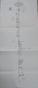
Map - UNITED HUSTLER'S & REDAN MINE - TRANSVERSE SECTION UNITED HUSTLER'S & REDAN MINE
... Mine Hustler's Line of Reef Geological Survey of Victoria H S Whitelaw Transverse Section of the United Hustler's & Redan Mine on the Hustler's Line of Reefs Bulletin No 33, Plate No XXIX. Map has drawing of poppet legs on the surface, depth of levels, type of stone encountered and some geological features. Sill of shaft 745.62 ft above sea level. Map has Geological Survey of Victoria emblem and signed by H S Whitelaw, Underground Survey Office Bendigo, 'September 1913. Map UNITED HUSTLER'S & REDAN MINE ...Transverse Section of the United Hustler's & Redan Mine on the Hustler's Line of Reefs Bulletin No 33, Plate No XXIX. Map has drawing of poppet legs on the surface, depth of levels, type of stone encountered and some geological features. Sill of shaft 745.62 ft above sea level. Map has Geological Survey of Victoria emblem and signed by H S Whitelaw, Underground Survey Office Bendigo, 'September 1913. mining, parish map, united hustler's & redan mine, hustler's line of reef, geological survey of victoria, h s whitelaw -
 Bendigo Historical Society Inc.
Map - K. K. MINE - TRANSVERSE SECTION K. K. MINE
... Mine Transverse Section of K. K. Mine Hustler's Line of Reefs Geological Survey of Victoria H S Whitelaw Transverse Section of the K. K. Mine on the Hustler's Line of Reefs, Bulletin No 33, Plate No XXXII. Map shows the different levels and their depth. Also, the different types of stone encountered and geological features such as spurs and faults. Has drawing of the poppet legs at the top of the shaft and sill of shaft 773.56 ft above sea ...Transverse Section of the K. K. Mine on the Hustler's Line of Reefs, Bulletin No 33, Plate No XXXII. Map shows the different levels and their depth. Also, the different types of stone encountered and geological features such as spurs and faults. Has drawing of the poppet legs at the top of the shaft and sill of shaft 773.56 ft above sea level. Map has Geological Survey of Victoria crest and signed by H S Whitelaw, Underground Survey Office Bendigo, September 1913. miners, fortuna hustler's mine, transverse section of k. k. mine, hustler's line of reefs, geological survey of victoria, h s whitelaw -
 Bendigo Historical Society Inc.
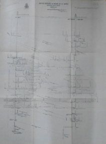
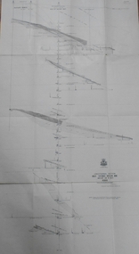
Map - HUSTLERS LINE OF REEFS - LONGITUDINAL SECTION THROUGH THE SADDLE REEFS
... mines, reef numbers and Datum 700 ft above sea level. North and South is also noted on the map. Map signed by H. S, Whitelaw, Underground Survey Office, Bendigo, September 1913. Bulletin No 33, Plate No XXXIV. Bendigo Creek, Ironbark Creek and Long Gully are also noted. Mines are: Fortuna Hustlers, Hustler's Royal Reserve No 2 Main Shaft, Hustler's Royal Reserve No 2 Park Shaft, Royal Hustler's, Imperial Hustler's, Extended Hustler's Freehold, Great Extended Hustler's Tribute (Pups), Old Shaft, Great Extended Hustler's Reef No 2, Great Extended Hustler's Main Shaft, Old Shaft, Hustler's Reef, Hustler's Reef No 1, Comet, K. K., United Hustler's & Redan, Old Shaft and Hustler's Consols. Has Geological Survey of Victoria Crest and underneath is: H. Herman, Director, W. Dickson, Secretary for Mines...mines, reef numbers and Datum 700 ft above sea level. North and South is also noted on the map. Map signed by H. S, Whitelaw, Underground Survey Office, Bendigo, September 1913. Bulletin No 33, Plate No XXXIV. Bendigo Creek, Ironbark Creek and Long Gully are also noted. Mines are: Fortuna Hustlers, Hustler's Royal Reserve No 2 Main Shaft, Hustler's Royal Reserve No 2 Park Shaft, Royal Hustler's, Imperial Hustler's, Extended Hustler's Freehold, Great Extended Hustler's Tribute (Pups), Old Shaft, Great Extended Hustler's Reef No 2, Great Extended Hustler's Main Shaft, Old Shaft, Hustler's Reef, Hustler's Reef No 1, Comet, K. K., United Hustler's & Redan, Old Shaft and Hustler's Consols. Has Geological Survey of Victoria Crest and underneath is: H. Herman, Director, W. Dickson, Secretary for Mines ...Drawing with Longitudinal Section through the Saddle Reefs along portion of Hustler's Line of Reefs, Bendigo. Map shows the depth of the mines, reef numbers and Datum 700 ft above sea level. North and South is also noted on the map. Map signed by H. S, Whitelaw, Underground Survey Office, Bendigo, September 1913. Bulletin No 33, Plate No XXXIV. Bendigo Creek, Ironbark Creek and Long Gully are also noted. Mines are: Fortuna Hustlers, Hustler's Royal Reserve No 2 Main Shaft, Hustler's Royal Reserve No 2 Park Shaft, Royal Hustler's, Imperial Hustler's, Extended Hustler's Freehold, Great Extended Hustler's Tribute (Pups), Old Shaft, Great Extended Hustler's Reef No 2, Great Extended Hustler's Main Shaft, Old Shaft, Hustler's Reef, Hustler's Reef No 1, Comet, K. K., United Hustler's & Redan, Old Shaft and Hustler's Consols. Has Geological Survey of Victoria Crest and underneath is: H. Herman, Director, W. Dickson, Secretary for Mines, The Hon. J Drysdale Brown M L C. Minister of Mines.Geological Survey of Victoria Crestmining, hustler's reef maps, hustlers line of reefs, bendigo creek, royal hustler's, imperial hustler's, extended hustler's freehold, great extended hustler's tribute (pups), great extended hustler's reef no 2, great extended hustler's main shaft, hustler's reef, hustler's reef no 1, united hustler's & redan, old shaft and hustler's consols.h s whitelaw, underground survey office bendigo september 1913 -
 Bendigo Historical Society Inc.
Map - GREAT EXTENDED HUSTLER'S MINE - LONGITUDINAL SECTION OF THE GREAT EXTENDED HUSTLER'S MINE
... Mine on the Hustler's Line of Reefs. Bulletin No 33, Plate No XIII. Map shows the Hustler's Tribute, 2 Old Shafts, Great Extended Hustler's Shaft, Latham & Watson's Shaft and Ironbark Gully. Datum Line 750 feet above Sea Level. Poppet Legs on the surface and Sill of Shaft 788.99 feet above Sea Level. Levels and their depths are shown and some geographical features. Some amounts of gold mined mentioned. Geological Survey of Victoria emblem and signed by H A Whitelaw, Underground Survey Office Bendigo, September 1913. Note - Plates 4, 8, 13,20, 26 & 31 form a Longitudinal Section from Fortuna Hustlers to Hustler's Consols Mine...Mine Geological Survey of Victoria Underground Survey Office Bendigo H A Whitelaw Hustler's Tribute Old Shaft Great Extended Hustler's Shaft Latham & Watson's Shaft Ironbark Gully Longitudinal Section of the Great Extended Hustler's Mine on the Hustler's Line of Reefs. Bulletin No 33, Plate No XIII. Map shows the Hustler's Tribute, 2 Old Shafts, Great Extended Hustler's Shaft, Latham & Watson's Shaft and Ironbark Gully. Datum Line 750 feet above Sea Level. Poppet Legs on the surface and Sill of Shaft 788.99 feet above Sea Level. Levels and their depths are shown and some geographical features. Some amounts of gold mined ...Longitudinal Section of the Great Extended Hustler's Mine on the Hustler's Line of Reefs. Bulletin No 33, Plate No XIII. Map shows the Hustler's Tribute, 2 Old Shafts, Great Extended Hustler's Shaft, Latham & Watson's Shaft and Ironbark Gully. Datum Line 750 feet above Sea Level. Poppet Legs on the surface and Sill of Shaft 788.99 feet above Sea Level. Levels and their depths are shown and some geographical features. Some amounts of gold mined mentioned. Geological Survey of Victoria emblem and signed by H A Whitelaw, Underground Survey Office Bendigo, September 1913. Note - Plates 4, 8, 13,20, 26 & 31 form a Longitudinal Section from Fortuna Hustlers to Hustler's Consols Mine. mining, parish map, great extended hustler's mine, geological survey of victoria, underground survey office bendigo, h a whitelaw, hustler's tribute, old shaft, great extended hustler's shaft, latham & watson's shaft, ironbark gully -
 Bendigo Historical Society Inc.
Map - GREAT EXTENDED HUSTLER'S MINE - TRANSVERSE SECTION OF THE GREAT EXTENDED HUSTLER'S MINE
... History House 11 Mackenzie Street Bendigo goldfields MINING Parish Map Great Extended Hustler's Mine Transverse Section of the Great Extended Hustler's Mine Old Shaft Mr Walker Mr Craven Geological Survey of Victoria Underground Survey Office Bendigo H A Whitelaw Transverse Section of the Great Extended Hustler's Mine on the Hustler's Line of Reef. Bulletin No 33, Plate No XII. Shows Poppet legs at the surface and Sill of Shaft at 788.99 feet above Sea ...Transverse Section of the Great Extended Hustler's Mine on the Hustler's Line of Reef. Bulletin No 33, Plate No XII. Shows Poppet legs at the surface and Sill of Shaft at 788.99 feet above Sea Level, Cross Cuts and their depths, stone and geographical features encountered and their references and a number of enlarged drawing of sections of the crosscuts, Geological Survey of Victoria emblem and signed by H A Whitelaw, Underground Survey Office Bendigo, September 1913. The depths of crosscuts to No 21 were taken from plans of surveys by Mr. Walker and Mr. Craven, noted under Reference. Another note: This Saddle Reef is sketched from Mr. Walker's plan. Dividends amounting to 360,000 pounds were obtained from it. mining, parish map, great extended hustler's mine, transverse section of the great extended hustler's mine, old shaft, mr walker, mr craven, geological survey of victoria, underground survey office bendigo, h a whitelaw -
 Bendigo Historical Society Inc.
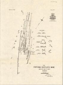
Map - FORTUNA HUSTLER'S MINE - TRANSVERSE SECTION OF THE FORTUNA HUSTLER'S MINE
... Mine Hustler's Line of Reef Geological Survey of Victoria Underground Survey office Bendigo H A Whitelaw Transverse Section of the Fortuna Hustler's Mine on the Hustler's Line of Reef, Bendigo. Bulletin No 33, Plate No III. Drawing shows poppet legs on the surface and Sill of Shaft 745.38 feet above Sea Level. Shows levels and their depths, geographical features and stone encountered. Reference table to stone and geographical features. Geographical Survey of Victoria emblem. Signed by H A Whitelaw, Underground Survey Office, Bendigo. Map FORTUNA HUSTLER'S MINE ...Transverse Section of the Fortuna Hustler's Mine on the Hustler's Line of Reef, Bendigo. Bulletin No 33, Plate No III. Drawing shows poppet legs on the surface and Sill of Shaft 745.38 feet above Sea Level. Shows levels and their depths, geographical features and stone encountered. Reference table to stone and geographical features. Geographical Survey of Victoria emblem. Signed by H A Whitelaw, Underground Survey Office, Bendigo. mining, fortuna hustler's mine, hustler's line of reef, geological survey of victoria, underground survey office bendigo, h a whitelaw -
 Bendigo Historical Society Inc.
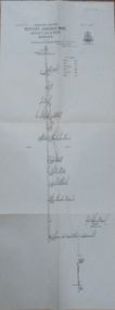
Map - FORTUNA HUSTLER'S MINE - LONGITUDINAL SECTION OF THE FORTUNA HUSTLER'S MINE
... Mine on the Hustler's Line of Reef, Bendigo. Bulletin No 33, Plate No IV. Shows poppet legs at the surface level, Datum Line 750 feet above Sea Level, levels and their depths, the amount of gold per ton and some geographical features. Geological Survey of Victoria emblem and signed by H A Whitelaw, Underground Survey Office, Bendigo. Note - Plates 4, 8, 13, 20, 26 & 31 form a Longitudinal Section from Fortuna Hustler's to Hustler's Consols Mine...History House 11 Mackenzie Street Bendigo goldfields MINING Parish Map Fortuna Hustler's Mine Longitudinal Section of the Fortuna Hustler's Mine Geological Survey of Victoria H A Whitelaw Underground Survey Office Bendigo Hustler's Line of Reef Hustler's Consols Mine Longitudinal Section of the Fortuna Hustler's Mine on the Hustler's Line of Reef, Bendigo. Bulletin No 33, Plate No IV. Shows poppet legs at the surface level, Datum Line 750 feet above Sea ...Longitudinal Section of the Fortuna Hustler's Mine on the Hustler's Line of Reef, Bendigo. Bulletin No 33, Plate No IV. Shows poppet legs at the surface level, Datum Line 750 feet above Sea Level, levels and their depths, the amount of gold per ton and some geographical features. Geological Survey of Victoria emblem and signed by H A Whitelaw, Underground Survey Office, Bendigo. Note - Plates 4, 8, 13, 20, 26 & 31 form a Longitudinal Section from Fortuna Hustler's to Hustler's Consols Mine. mining, parish map, fortuna hustler's mine, longitudinal section of the fortuna hustler's mine, geological survey of victoria, h a whitelaw, underground survey office bendigo, hustler's line of reef, hustler's consols mine -
 Bendigo Historical Society Inc.
Map - HUSTLER'S CONSOLS MINE - TRANSVERSE SECTION OF THE HUSTLER'S CONSOLS MINE
... History House 11 Mackenzie Street Bendigo goldfields MINING Parish Map Hustler's Consols Mine Transverse Section of the Hustler's Consols Mine Geological Survey of Victoria Underground Survey Office Bendigo H A Whitelaw Transverse Section of the Hustler's Consols Mine Bulletin No 33, Plate No XXXIII. Map shows poppet legs at the surface and Sill of Shaft 779.42 feet above Sea ...Transverse Section of the Hustler's Consols Mine Bulletin No 33, Plate No XXXIII. Map shows poppet legs at the surface and Sill of Shaft 779.42 feet above Sea Level. Shows the different levels and their depths and the different stone and geographical features encountered. Has larger drawing of Section A - B. Geographical Survey of Victoria. Signed by H A Whitelaw, Underground Survey Office Bendigo, September 1913. mining, parish map, hustler's consols mine, transverse section of the hustler's consols mine, geological survey of victoria, underground survey office bendigo, h a whitelaw -
 Bendigo Historical Society Inc.
Map - HUSTLER'S REEF MINE - TRANSVERSE SECTION OF THE HUSTLER'S REEF MINE
... Mine transverse Section of the Hustler's Reef Mine Geological Survey of Victoria H A Whitelaw Underground Survey Office Bendigo Thompson's Reef. Transverse Section of the Hustler's Reef Mine on the Hustler's Line of Reefs. Bulletin No 33, Plate No XVIII. Shows cross-cuts and their depth, different types of stone and geological features encountered. Drawing of poppet legs at the surface and Sill of Shaft 756.39 ft above Sea ...Transverse Section of the Hustler's Reef Mine on the Hustler's Line of Reefs. Bulletin No 33, Plate No XVIII. Shows cross-cuts and their depth, different types of stone and geological features encountered. Drawing of poppet legs at the surface and Sill of Shaft 756.39 ft above Sea Level. Reference Table shows key to the different stone and geographical features encountered. Geographical Survey of Victoria. Signed by H A Whitelaw, Underground Survey Office, Bendigo, September 1913. Thompson's Reef is also mentioned on the map. mining, hustler's reef mine, transverse section of the hustler's reef mine, geological survey of victoria, h a whitelaw, underground survey office bendigo, thompson's reef.