Showing 129 items matching "mining tunnels"
-
 The Beechworth Burke Museum
Photograph, Unknown
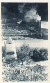
... ...mining tunnels...The photograph contributes to our understanding of the A1 Gold Mine's impact on the landscape and the social, environmental impacts of mining on communities and may be compared with others in the Burke Museum's extensive collection of mining photographs to deepen our understanding of mining in the Jamieson area. burke museum beechworth museum beechworth gold fields gold rush victorian gold rush mining tunnels gold ming history colonial australia australian gold rushes mining technology beechworth historic district indigo gold trail indigo shire upper goulburn shire jamieson woods point-walhalla goldfield a1 gold mine victorian high country modern mining methods orogenic gold province gold mineralisation devonian dykes Reverse: 5577 / A1 Mine / Near Jamieson / Vic. / Black and white rectangular photograph printed on photographic paper Photograph Photograph ...The A1 Gold Mine is located north of Woods Point, near Jamieson, in the Upper Goulburn region of Victoria. Gold was discovered at the A1 site in 1861 and mining operations began in 1864. The A1 Mine Settlement refers to a small township known variously as Castle Reef, Castle Point, and Raspberry Creek, which developed in the 1860s around mining industry centred on a crushing machine that worked the three gold reefs in the area. Historically, the name "A1"referred to the high quality of gold found in the quartz reefs at depths of at least two thousand feet. Along with the Morning Star mine at Woods Point, the A1 gold mine produced almost sixty percent of Victoria's gold output in the 1950s to 1970s and continued operating until 1992 when it went into administration. Operations at the site were revived in 2016 and the A1 Mine is now considered one of Victoria's premier gold mines. The A1 mine is part of the extensive and prospective Lachlan Fold Belt, a north-west trending belt of tightly folded Early Devonian sedimentary rocks extending from New South Wales to Victoria. Mineralisation is hosted within or immediately adjacent to diorite dykes. Contemporary development of the 'Queens Lode' at the A1 mine signals a move from high-grade, narrow vein airleg mining into larger scale, mechanical mining designed to increase ore production volume. This original, undated photograph of the A1 Mine appears to depict an area or phase of disuse or abandonment. The aged and humble appearance of the cottage suggests association with the historical A1 Mine Settlement, therefore the image may have been taken prior to the 1950s-1970s revival period in which the A1 mine is known to have produced high gold yields. The photograph contributes to our understanding of the A1 Gold Mine's impact on the landscape and the social, environmental impacts of mining on communities and may be compared with others in the Burke Museum's extensive collection of mining photographs to deepen our understanding of mining in the Jamieson area.Black and white rectangular photograph printed on photographic paperReverse: 5577 / A1 Mine / Near Jamieson / Vic. /burke museum, beechworth museum, beechworth, gold fields, gold rush, victorian gold rush, mining tunnels, gold ming history, colonial australia, australian gold rushes, mining technology, beechworth historic district, indigo gold trail, indigo shire, upper goulburn shire, jamieson, woods point-walhalla goldfield, a1 gold mine, victorian high country, modern mining methods, orogenic gold province, gold mineralisation, devonian, dykes -
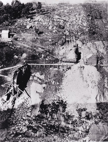
 The Beechworth Burke Museum
Photograph - Photograph - Reproduction, ca. 1900
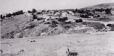
... ...mining tunnels...The site in the photograph is associated with the Rocky Mountain Mining Company who constructed an eight hundred meter tunnel under the township between 1876-1880 to reduce water levels at Spring Creek, which had been subject to diversions since the earliest days of alluvial mining. ...The shift from smaller scale alluvial mining to larger company dominance in the mining industry has implications for understanding wider social, economic, political and industrial changes in the region of Beechworth and within the context of the Victorian Gold Rush more broadly. burke museum beechworth museum beechworth gold fields gold rush victorian gold rush hydraulic sluicing rocky mountain mining company spring creek netwown falls mining tunnels water races tailraces colonial australia australian gold rushes mining technology beechworth historic district indigo gold trail migration indigo shire gold mining gold mining history A black and white rectangular reproduction photograph printed on photographic paper. ...This image shows the approach to Beechworth from the south-west via the Newtown Bridge. Numerous early buildings line the road as it bifurcates to become Ford and High Streets on the ridge above Spring Creek and Newtown Falls. The sloping, rocky terrain and water course along the gorge show evidence of the intense mining activity that occurred at the site. The Ovens Gold Rush at Beechworth started when gold was found at Spring Creek in February 1852, prompting an influx of miners from around the world. The population grew over 20,000 by 1857. While the earliest mining at Beechworth was similar to that in other Victorian goldfields like Ballarat and Bendigo, Beechworth is notable for its use of hydraulic sluicing as a major method of removing wash-dirt. Hydraulic sluicing employs high pressure jets of water to blast away large areas of earth and wash it down to be run through a sluice box. Gold gets caught in the sluice and the remaining slurry is washed away. This method of mining is extremely effective but causes significant environmental impacts and damage to waterways. Large water quantities were required for large-scale sluicing, and the long water races and deep tailraces that were constructed in the Beechworth area in the nineteenth century are nonetheless considered feats of engineering. The site in the photograph is associated with the Rocky Mountain Mining Company who constructed an eight hundred meter tunnel under the township between 1876-1880 to reduce water levels at Spring Creek, which had been subject to diversions since the earliest days of alluvial mining. Over four million ounces of gold (115 tones) were found at Beechworth between 1852 and 1868, and the wealth from the gold rushes built Beechworth and the nationally significant buildings that remain standing today.This image shows the early development of the Beechworth township above Spring Creek, where gold was discovered in 1852. Evidence of hydraulic sluicing, a uniquely predominant method at Beechworth, and water-works engineering are present in the landscape. By the 1870s, alluvial gold deposits were depleted and increasingly complex engineering was required so deeper shafts could reach bedrock. This image is significant for understanding changes to the landscape and the evolution of mining methods and engineering practices related to the extensive construction, manipulation and management of water networks. The shift from smaller scale alluvial mining to larger company dominance in the mining industry has implications for understanding wider social, economic, political and industrial changes in the region of Beechworth and within the context of the Victorian Gold Rush more broadly. A black and white rectangular reproduction photograph printed on photographic paper. burke museum, beechworth museum, beechworth, gold fields, gold rush, victorian gold rush, hydraulic sluicing, rocky mountain mining company, spring creek, netwown falls, mining tunnels, water races, tailraces, colonial australia, australian gold rushes, mining technology, beechworth historic district, indigo gold trail, migration, indigo shire, gold mining, gold mining history -
 The Beechworth Burke Museum
Photograph, 1920-1950
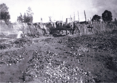
... ...mining tunnels...This photograph has historic and research potential for understanding changes to the landscape, the evolution of mining methods, and the extensive construction, manipulation and management of water networks in the Beechworth district. burke museum beechworth museum beechworth gold fields gold rush victorian gold rush hydraulic sluicing spring creek netwown falls mining tunnels water races tailraces gold ming history colonial australia australian gold rushes mining technology beechworth historic district indigo gold trail indigo shire john pund water manipulation water engineering three mile creek three mile mine water race large-scale mining methods historical mining construction alluvial mining mining environmental impacts baarmutha water barons Reverse: 7597-1 / Sluice Mining / Copied from original on loan from Webb (Qld) / Donated Nov 2009 / Baarmutha Three Mile Mine c1920-1950 / Managed by the Plain Bros then Parkinsons / Current Location is: Beechworth Animal Shelter / used for Baarmutha Black and white rectangular photograph on matte paper Photograph Photograph ...This image taken between 1920-1930 depicts open-cut hydraulic sluicing at the Three Mile Mine, located about five kilometres south of Beechworth. Alluvial, or surface, mining began on this site in the 1850s, but was soon replaced by hydraulic sluicing methods. By the start of 1880 it is estimated that nine hundred miles of water races had been cut though soil and rock in the Beechworth district. Hydraulic sluicing employs high pressure jets of water to blast away large areas of earth and wash it down to be run through a sluice box. Gold gets caught in the sluice and the remaining slurry is washed away. Large water quantities were required for hydraulic sluicing, and the long water races and deep tailraces that were constructed were considered great engineering feats. This method of mining is extremely effective, but causes significant environmental damage and impacts to waterways and agricultural operations. Miners at Beechworth built extensive networks of races and dams to secure reliable supplies of water on a scale far greater than elsewhere in Victoria. By the 1880s Beechworth's water barons continued to hold more than half of all the water right licences on issue and undertook sluicing operations on a massive scale. The manipulation of surface and ground water via race networks was well planned and recorded in detail by local mining surveyors. The maps that were created, combined with modern geo-spatial technologies, provide a vital key in understanding the great lengths to which miners went to capture and control critical water resources. Today, Three Mile mine is called Baarmutha. The Three Mile Mine was unproductive until 1865 when John Pund and three other miners secured a fifteen year license and constructed a water race from Upper Nine Mile Creek to Three Mile Creek. In the early twentieth century Pund & Co. averaged over one thousand ounces of gold per year from the mine. After Pund's death in 1915, GSG Amalgamated Co operated the site, continuing sluicing until 1950. This image of hydraulic sluicing methods shows the extent of water-works engineering in the landscape. This photograph has historic and research potential for understanding changes to the landscape, the evolution of mining methods, and the extensive construction, manipulation and management of water networks in the Beechworth district. Black and white rectangular photograph on matte paperReverse: 7597-1 / Sluice Mining / Copied from original on loan from Webb (Qld) / Donated Nov 2009 / Baarmutha Three Mile Mine c1920-1950 / Managed by the Plain Bros then Parkinsons / Current Location is: Beechworth Animal Shelter / used for Baarmuthaburke museum, beechworth museum, beechworth, gold fields, gold rush, victorian gold rush, hydraulic sluicing, spring creek, netwown falls, mining tunnels, water races, tailraces, gold ming history, colonial australia, australian gold rushes, mining technology, beechworth historic district, indigo gold trail, indigo shire, john pund, water manipulation, water engineering, three mile creek, three mile mine, water race, large-scale mining methods, historical mining construction, alluvial mining, mining environmental impacts, baarmutha, water barons -
 Coal Creek Community Park & Museum
Mine Map
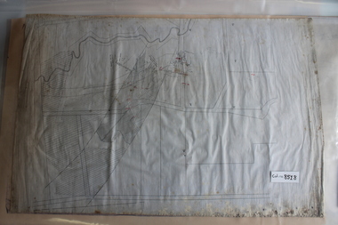
... 8518.1 - Unlabelled map of mining tunnels, coal seams, boreholes, creeks, roads and (presumably) paddock boundaries. ...Coal Creek Community Park & Museum 12 Silkstone Road Korumburra gippsland 8518.1 - Unlabelled map of mining tunnels, coal seams, boreholes, creeks, roads and (presumably) paddock boundaries. ...8518.1 - Unlabelled map of mining tunnels, coal seams, boreholes, creeks, roads and (presumably) paddock boundaries. Based on features in common with other maps, very likely map of Korumburra area. -
 Federation University Historical Collection
Book, Hoisting and Hoisting Appliances, 1900
... mining...tools...tunnels...Barker Library (top floor) Mount Helen goldfields mining tools tunnels timbering illustrations ventilation hoisting prospecting Brown, half leather bound book including sections of hoisting, prospecting, placer and hydraulic Mining, Preliminary Operations at Metal Mines, Metal Mining and Surface Arrangements at Metal Mines. ...Brown, half leather bound book including sections of hoisting, prospecting, placer and hydraulic Mining, Preliminary Operations at Metal Mines, Metal Mining and Surface Arrangements at Metal Mines. The book includes illustrations and an index.mining, tools, tunnels, timbering, illustrations, ventilation, hoisting, prospecting -
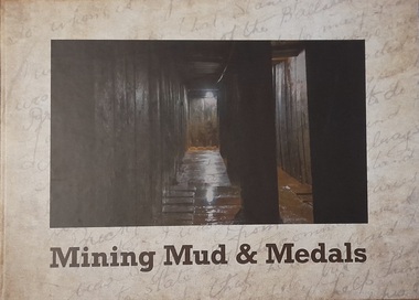 Hymettus Cottage & Garden Ballarat
Work on paper - Book, Mining Mud & Medals
... This is a series of chapters dealing with servicemen who had Ballarat connections and served in the mining, tunnelling and engineering efforts in the First World War. ...Hymettus Cottage & Garden Ballarat 8 Cardigan St Lake Wendouree goldfields This is a series of chapters dealing with servicemen who had Ballarat connections and served in the mining, tunnelling and engineering efforts in the First World War. ...Hard covered book on the members of the Australian Tunnelling Corp from the Ballarat Electorate during World War One.non-fictionHard covered book on the members of the Australian Tunnelling Corp from the Ballarat Electorate during World War One.world war i, tunnellers, australian mining corps, michael taffe, clare gervasoni, yvon davis, school of mines ballarat -
 Federation University Historical Collection
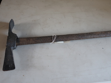
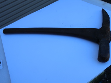
Tool - Picks, Miner's Pick
... This type of pick used in mining and tunnelling....Barker Library (top floor) Mount Helen goldfields This type of pick used in mining and tunnelling. mining pick tools trades Metal, slightly curved sharp end with hammerable top end. ...This type of pick used in mining and tunnelling.Metal, slightly curved sharp end with hammerable top end. Open hole for handle which would have been wood.mining, pick, tools, trades -
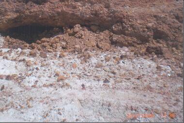 Bendigo Historical Society Inc.
Photograph - RALPH BIRRELL COLLECTION: WHITE HILLS MINING SITE
... Loose sand and gravel above the cement has already been removed. Image shows mining tunnel visible going in under the cement. ...Loose sand and gravel above the cement has already been removed. Image shows mining tunnel visible going in under the cement. ...Colour photograph 'showing tunnels below the cement where the miners chipped the undersurface to get the gold The thickness of the cement can be seen'. Loose sand and gravel above the cement has already been removed. Image shows mining tunnel visible going in under the cement. White clay in foreground. (see Mosaic 4400.220 for detailed information regarding the White Hills, written by Dr. Ralph Birrell)bendigo, mining, white hills -
 Federation University Historical Collection
Book, Mines Department, Victoria, Deep Leads of Victoria, 1937, 1937
... Contents include Ballarat, berry Consols, Canadian Lead, Castlemaine-Daylesford System, Chiltern, Duke of Cornwall Mine, Dyke's Freehold, Frenchman's Lead, Garibaldi Shaft, Glenfine, Guidlford, Hepburn Estate Co., Hepburn Home Paddock, Italian Gully, Henderson's Lead, Langi Logan, Leigh Consols, Sebastopol Plateau; Talbot, Woady Yalloak, A definition of a deep lead, formation of deep leads, water in deep leads, methods of deep lead mining (Tunnelling, Deep sinking, Chiltern method of working, Ballarat method of working), sampling washdirt and gravels, Balmoral, Mt William, Stawell, Moyston, Great Western, Ararat, Raglan, Wimmera Valley, Landsborough, Cardigan, Haddon, Beaufort, Waterloo, Avoca, Lamplough, Caralulup, Ballarat West, Ballarat, Smythesdale, Glenfine, Illabarook, Durham Lead, Morrison's Lead, Bullengarook, Berry-Moolort-Loddon System, Clunes, Creswick, Spring Hill, Bullarook, Castlemaine - Daylesford, Majorca, Carisbrook, Timor, Burnt Creek Tributary, Tarnagulla, Marong, Rheola, Inglewood, Huntly, Coliban, Campaspe, Goulburn Lead System, Ovens Valley System, Mitta Mitts, Kiewa Valley, Tarago, Tanjil, Moondarra, Bogong, Dargo High Plains, glossary...Contents include Ballarat, berry Consols, Canadian Lead, Castlemaine-Daylesford System, Chiltern, Duke of Cornwall Mine, Dyke's Freehold, Frenchman's Lead, Garibaldi Shaft, Glenfine, Guidlford, Hepburn Estate Co., Hepburn Home Paddock, Italian Gully, Henderson's Lead, Langi Logan, Leigh Consols, Sebastopol Plateau; Talbot, Woady Yalloak, A definition of a deep lead, formation of deep leads, water in deep leads, methods of deep lead mining (Tunnelling, Deep sinking, Chiltern method of working, Ballarat method of working), sampling washdirt and gravels, Balmoral, Mt William, Stawell, Moyston, Great Western, Ararat, Raglan, Wimmera Valley, Landsborough, Cardigan, Haddon, Beaufort, Waterloo, Avoca, Lamplough, Caralulup, Ballarat West, Ballarat, Smythesdale, Glenfine, Illabarook, Durham Lead, Morrison's Lead, Bullengarook, Berry-Moolort-Loddon System, Clunes, Creswick, Spring Hill, Bullarook, Castlemaine - Daylesford, Majorca, Carisbrook, Timor, Burnt Creek Tributary, Tarnagulla, Marong, Rheola, Inglewood, Huntly, Coliban, Campaspe, Goulburn Lead System, Ovens Valley System, Mitta Mitts, Kiewa Valley, Tarago, Tanjil, Moondarra, Bogong, Dargo High Plains, glossary Deep Leads of Victoria, 1937 Book Book H.J. ...Charcoal green soft covered book of 64 pages. Contents include Ballarat, berry Consols, Canadian Lead, Castlemaine-Daylesford System, Chiltern, Duke of Cornwall Mine, Dyke's Freehold, Frenchman's Lead, Garibaldi Shaft, Glenfine, Guidlford, Hepburn Estate Co., Hepburn Home Paddock, Italian Gully, Henderson's Lead, Langi Logan, Leigh Consols, Sebastopol Plateau; Talbot, Woady Yalloak, A definition of a deep lead, formation of deep leads, water in deep leads, methods of deep lead mining (Tunnelling, Deep sinking, Chiltern method of working, Ballarat method of working), sampling washdirt and gravels, Balmoral, Mt William, Stawell, Moyston, Great Western, Ararat, Raglan, Wimmera Valley, Landsborough, Cardigan, Haddon, Beaufort, Waterloo, Avoca, Lamplough, Caralulup, Ballarat West, Ballarat, Smythesdale, Glenfine, Illabarook, Durham Lead, Morrison's Lead, Bullengarook, Berry-Moolort-Loddon System, Clunes, Creswick, Spring Hill, Bullarook, Castlemaine - Daylesford, Majorca, Carisbrook, Timor, Burnt Creek Tributary, Tarnagulla, Marong, Rheola, Inglewood, Huntly, Coliban, Campaspe, Goulburn Lead System, Ovens Valley System, Mitta Mitts, Kiewa Valley, Tarago, Tanjil, Moondarra, Bogong, Dargo High Plains, glossarymining, deep leads, mines department, squire, leigh consols, chiltern, duke of cornwall mine, dyke's freehold, frenchman's lead, garibaldi shaft, glenfine, guidlford, hepburn estate co., hepburn home paddock, italian gully, henderson's lead, langi logan, sebastopol plateau, talbot, woady yalloak, tunnelling, deep sinking, chiltern method of working, ballarat method of working, sampling washdirt. gravels, balmoral, mt william, stawell, moyston, great western, ararat, raglan, wimmera valley, landsborough, cardigan, haddon, beaufort, waterloo, avoca, lamplough, caralulup, ballarat west, ballarat, smythesdale, illabarook, durham lead, morrison's lead, bullengarook, berry-moolort-loddon system, clunes, creswick, spring hill, bullarook, castlemaine - daylesford, majorca, carisbrook, timor, burnt creek tributary, tarnagulla, marong, rheola, inglewood, huntly, coliban, campaspe, goulburn lead system, ovens valley system, mitta mitta, kiewa valley, tarago, tanjil, moondarra, bogong, dargo high plains -
 Bendigo Military Museum
Administrative record - ADMINISTRATIVE RECORD, WW1, The Australian Mining Corps Memorial Campaign Inc, "Victorian Members of the Australian Mining Corps 1916-1919", unknown
... After May 1916 the four constituent companies of the Australian Mining Corps were deployed directly as part of the Tunnelling Companies of the Royal Engineers. list produced by "The Australian Mining Corps Memorial Campaign Inc"....After May 1916 the four constituent companies of the Australian Mining Corps were deployed directly as part of the Tunnelling Companies of the Royal Engineers. list produced by "The Australian Mining Corps Memorial Campaign Inc". ..."Victorian Members of the Australian Mining Corps 1916 - 1919". The 4 mining units formed by the Royal Australian Engineers for the British Expeditionary Force departed Australia for the United Kingdom 1916. After May 1916 the four constituent companies of the Australian Mining Corps were deployed directly as part of the Tunnelling Companies of the Royal Engineers. list produced by "The Australian Mining Corps Memorial Campaign Inc".1. & 2. Record document - facsimile copy of names. Black print on white paper. Both 8 pages - printed on one side, white paper. Stapled top left corner.records, royal australian engineers, tunnellers, ww1 -
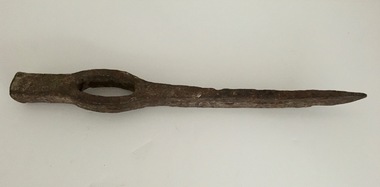
 Kiewa Valley Historical Society
Miners Pick - long
... tunnels. Found in the Harrietville area. Similar to those used in the nearby Kiewa Valley where prospecting for gold was also an occupation. gold mining miners' pick Formerly KV 071. ...Miners' picks were commonly used in the nineteenth and early twentieth century for extracting gold from underground mine tunnels.Found in the Harrietville area. Similar to those used in the nearby Kiewa Valley where prospecting for gold was also an occupation.Formerly KV 071. Handmade - of steel with a wooden handle. It was used to break up rock and ore, making it easier to extract valuable minerals. The pointed end of the pickaxe was used to chip away at rock, while the flat end was used to strike the rock for breaking it apart. This one has a long handle.gold mining, miners' pick -
 Kiewa Valley Historical Society
Miners Pick - short
... tunnels. Used in the Kiewa Valley where prospecting for gold occurred. gold mining miners' pick axe hand tool Formerly KV 071. ...Formerly KV 071. It was used to break up rock and ore, making it easier to extract valuable minerals. The pointed end of the pick axe was used to chip away rock, while the flat end was used to strike the rock for breaking it apart. This one has a short handle. Miners picks were commonly used in the the 19th and early 20th centuries for extracting gold from underground mine tunnels.Used in the Kiewa Valley where prospecting for gold occurred.Formerly KV 071. Cast iron symmetrical pick tool on cast iron with a wooden handle. It has a pointed end and a flat end. It is 12 inches long.gold mining, miners' pick axe, hand tool -
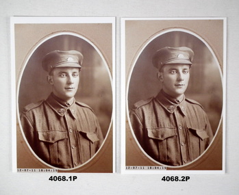 Bendigo Military Museum
Photograph - PHOTOGRAPHS WW1, C.1915
... Mining Corps Coy 3, aged 29 years and 6 months. Embarked for England 20.2.1916. KIA 27.1.1916 while serving with the 3rd Aust. Tunneling...Mining Corps Coy 3, aged 29 years and 6 months. Embarked for England 20.2.1916. KIA 27.1.1916 while serving with the 3rd Aust. Tunneling ....1) & .2) Albert Edward LADD (Bendigo) No. 1071, enlisted in the AIF on 1.8.15 in Mining Corps Coy 3, aged 29 years and 6 months. Embarked for England 20.2.1916. KIA 27.1.1916 while serving with the 3rd Aust. Tunneling Coy. This was at "Black Watch Sap Hill 70". The Germans were laying underground mines at the same time as the Australians. The Germans blew their mines at 12.40am, this combined with the Australian ammonal mines made a massive explosion killing over 20 Australians. Crumps & Camouflets by Damien Finlayson describes this in his book on pages 151-153. .3) In the photo are from left, Julia Ann Ladd, Rita Mary Ladd, Florence May Ladd and Albert Edward Ladd. Prewar, Albert worked at the "Coleman & Tachees Mine" in California Gully..1) & .2) Photos, sepia tone, portrait of a soldier in peak hat wearing a tie, oval shape with surround. .3) Photo, sepia tone, women with two children and soldier, one child on a setting, one on soldiers knee..1) & .2) Inset on front: "12.07.11-18.04.15" .3) Inset in front: "12.07.11-18.04.56photographs, 3rd, hill 70, kia -
 Federation University Historical Collection
Letter, Inward Correspondence to the Ballarat School of Mines, 1910, 08/1910
... mining company...n.j. wise...H.G. Taylor...Kout Morrien Harrow...L.F. Fairthorne & Sons...H.B. Silberberg & Co...Skipton...Henry F. Hull...Birthday Tunnel...mining company n.j. wise H.G. Taylor Kout Morrien Harrow L.F. Fairthorne & Sons H.B. Silberberg & Co Skipton Henry F. Hull Birthday Tunnel ...Inward Correspondence to the Ballarat School of Mines, August 1910letterhead, education department, roland graham, coleraine, m. carew, row brothers, mount gambier, joseph row, r. blackburn, max kohl, wilfred p. avery, jubilee hall, broken hill, frederick e. barclay, pharmacy board victoria, harry shinningham, hobson's gold mining company, macquarie steam brick yards, james dewar, henrey sotheran & co, piccadilly, london, salop, thomas parker, frank tate, dressmaking, steiglitz, telegram, postcard, lahasa fiji, r. palmerf, church of england grammar school of girls, f. abrams, radium hill, welcome gold mine, stanley b. white, new golden gate gold mining company, n.j. wise, h.g. taylor, kout morrien harrow, l.f. fairthorne & sons, h.b. silberberg & co, skipton, henry f. hull, birthday tunnel company, l. hansen, victorian railways, edmund c. earles, lawrence, r. welesteo, wellington cyanide works, clunes, octavius williams, h.j. thwaites, tolarno station, gilbert pa, gilbert palmer, wool sorting, r.j. webster, w.a.t. davies, henry markwald, e. rolland -
Federation University Historical Collection
Booklet, Leigh River Tunnel Gold Mining Co. Syndicate Books
... Leigh River Tunnel Gold Mining Co. Syndicate Books...Leigh River Tunnel Gold Mining Co....Richard Squire Leigh River Tunnel Gold Mining Co. Syndicate Book HY Peacock .1 Front cover torn but has notes written on it. .2 Leigh River Tunnel G 21st Call written on front .3 Leigh River Tunnel G 22nd Call written on front .4 Leigh River Tunnel G 23rd Call and figures written on front .5 3 shares isued out of this book, Leigh River Share Book No. 16 A 30 written on front Oblong booklets with green covers of syndicate share certificates .1 Dark Green cover 1923 all used .2 Light Green cover 1924 four pages used .3 Light Green cover 1924 all used .4 Light Green Cover 1924 all used .5 light Green Cover 1918 - 1919 four pages used Leigh River Tunnel Gold Mining Co. ...Richard Squire was a student at the School of Mines Ballarat In 1905 Richard Squire was manager of the West Berry Consols at Allendale, and developed an improved system of mine ventilation, which was supported in "The Age." He was successful in combating and remedying the gas and ventilation troubles of the Deep Mines of Creswick and Allendale Districts after all had failed. MINE MANAGERS’ ASSOCIATION. Ballarat Branch. ... Mr R. B. Squire, manager of the West Berry Consols, at Allendale, submitted a paper detailing what he had done tor the betterment of ventilation in the alluvial mines of Smeaton and Mary borough districts- Members gave Mr Squire every credit for the results that he claimed to have effected; the adoption of his ideas had testified to their value to mine-owners. It was painted out, however, that for want of a thorough debate of the subject with experienced men the author had unwittingly included some general statements that required modifying in some points and extending in others, in justice to other workers among the earlier and the present day managers of mines. It was decided to invite the author to meet a sub-committee on this subject!Oblong booklets with green covers of syndicate share certificates .1 Dark Green cover 1923 all used .2 Light Green cover 1924 four pages used .3 Light Green cover 1924 all used .4 Light Green Cover 1924 all used .5 light Green Cover 1918 - 1919 four pages used .1 Front cover torn but has notes written on it. .2 Leigh River Tunnel G 21st Call written on front .3 Leigh River Tunnel G 22nd Call written on front .4 Leigh River Tunnel G 23rd Call and figures written on front .5 3 shares isued out of this book, Leigh River Share Book No. 16 A 30 written on front richard squire, leigh river tunnel gold mining co., syndicate book, hy peacock -
 Federation University Historical Collection
Ephemera, Various papers relating to Richard Squire Mines
... tunnel syndicate...Federal Debt Collecting Coy...The Southern Extension of Main Ballarat Gold Fields...Telegram...Received Telegram...Mt Mercer Lease...Souvenir Telegram...Mining...Various papers relating to Richard Squire Mines including telegrams, reports, receipts, letters and newspaper clippings. .1 Souvenir Telegram .2 Telegram .3 Telegram .4 Telegram .5 Telegram .6 Telegram .7 Telegram .8 Telegram .9 Telegram .10 Telegram .11 Telegram .12 Telegram .13 Telegram .14 Telegram .15 Telegram .16 Newspaper article Mt Mercer Lease 8109, Ballarat .17 Report on the Southern Extension of Main Ballarat Goldfield .18 Letter from Harwood & Pincott Solicitors and Notaries re: Agreement .19 Ballarat Deep Leads Extensions .20 Leigh River Tunnel Syndicate Voucher x 4 .21 Debt Collector Letter .22 HY. W. Pearson Account .23 William Barrett Mining and General Blacksmith Quote and Account .24 Letter from Department of Mines, Melbourne dated 5th December 1934 .25 Letter from Mines Department, Melbourne dated 27th August 1937 .26 Documentsrelating to the purcghase of a wreath for R. ...Pearson William Barrett Ballarat Deep Lead Extension Harwood & Pincott Edmund Woodlock leigh river tunnel syndicate Federal Debt Collecting Coy The Southern Extension of Main Ballarat Gold Fields Telegram Received Telegram Mt Mercer Lease Souvenir Telegram Mining Date stamps Various papers relating to Richard Squire Mines including telegrams, reports, receipts, letters and newspaper clippings. .1 Souvenir Telegram .2 Telegram .3 Telegram .4 Telegram .5 Telegram .6 Telegram .7 Telegram .8 Telegram .9 Telegram .10 Telegram .11 Telegram .12 Telegram .13 Telegram .14 Telegram .15 Telegram .16 Newspaper article Mt Mercer Lease 8109, Ballarat .17 Report on the Southern Extension of Main Ballarat Goldfield .18 Letter from Harwood & Pincott Solicitors and Notaries re: Agreement .19 Ballarat Deep Leads Extensions .20 Leigh River Tunnel Syndicate Voucher x 4 .21 Debt Collector Letter .22 HY. ...In 1905 Richard Squire was manager of the West Berry Consols at Allendale, and developed an improved system of mine ventilation, which was supported in "The Age."[4] He was successful in combating and remedying the gas and ventilation troubles of the Deep Mines of Creswick and Allendale Districts after all had failed. MINE MANAGERS’ ASSOCIATION. Ballarat Branch. ... Mr R. B. Squire, manager of the West Berry Consols, at Allendale, submitted a paper detailing what he had done tor the betterment of ventilation in the alluvial mines of Smeaton and Mary borough districts- Members gave Mr Squire every credit for the results that he claimed to have effected; the adoption of his ideas had testified to their value to mine-owners. It was painted out, however, that for want of a thorough debate of the subject with experienced men the author had unwittingly included some general statements that required modifying in some points and extending in others, in justice to other workers among the earlier and the present day managers of mines. It was decided to invite the author to meet a sub-committee on this subject!Various papers relating to Richard Squire Mines including telegrams, reports, receipts, letters and newspaper clippings. .1 Souvenir Telegram .2 Telegram .3 Telegram .4 Telegram .5 Telegram .6 Telegram .7 Telegram .8 Telegram .9 Telegram .10 Telegram .11 Telegram .12 Telegram .13 Telegram .14 Telegram .15 Telegram .16 Newspaper article Mt Mercer Lease 8109, Ballarat .17 Report on the Southern Extension of Main Ballarat Goldfield .18 Letter from Harwood & Pincott Solicitors and Notaries re: Agreement .19 Ballarat Deep Leads Extensions .20 Leigh River Tunnel Syndicate Voucher x 4 .21 Debt Collector Letter .22 HY. W. Pearson Account .23 William Barrett Mining and General Blacksmith Quote and Account .24 Letter from Department of Mines, Melbourne dated 5th December 1934 .25 Letter from Mines Department, Melbourne dated 27th August 1937 .26 Documentsrelating to the purcghase of a wreath for R. Woolley .27 Prospectus of the Southern Leads .28 Propsal prospectus of Leigh River .29 Letter to Tom Squire from his brother Jim .30 Letter to Mr Squire from C Hayes regarding wages owed .31 3 copies of report on mine 8th August 1935 .32 Letter regarding unpaid account .33 Contributary causes of Collapse at Mt Mercer .34 Letter from D. Crawford re payment for timber .35 Letter from John McLeod apologising for not sending cheque .36 Letter from Department of Mines regarding Neil Cameron purchases of portions 64, 65. 66 and 71 .37 3 Letters from Department of Mines granting an extension of time to pay overdue rent. .38 Letter from Department of Mines regarding Mining Lease No. 8217 .39 Letter from Department of Mines regarding Lease Rents .40 Letter from the Department of Mines regarding further boring at Mt Mercer .41 Letter from E.R Hodge requesting that Richard Squire meet with Board members of Glenfine South .42 Letter from G Brown regarding Leases not being paid for .43 Letter from daughter Judy .44 Newspaper article regarding Berry United Deep Leads .45 Envelope addressed to R.T Squire Box 2 Tresco .46 Letter to Richard Squire from A.L. Read Date stamps richard squire, tom squire, jim squire, reports, contributary causes, account, c. hayes, proposal, prospectus, leigh river, southern leads, una cooperative society ltd., wreath, r. woolley, department of mines, e. woodlock, a.l. read, geo brown, hy. w. pearson, william barrett, ballarat deep lead extension, harwood & pincott, edmund woodlock, leigh river tunnel syndicate, federal debt collecting coy, the southern extension of main ballarat gold fields, telegram, received telegram, mt mercer lease, souvenir telegram, mining -
Federation University Historical Collection
Book, Jacobs Lewis Vines Architects and Conservation Planners, Historic Sites Survey: Ballarat Study Area, 1980, 1980
... tunnel mine...pitfield plains...smythesdale...buninyong company...Mount Clear...mt clear...canadian gully...Warrenheip Distillery...thomas mitchell...waterloo...trawalla...beaufort...raglan...internment camps...forestry...mining...Barker Library (top floor) Mount Helen goldfields This survey was commissioned by the Land Conservation Council, Australian Heritage Commission and the Ministry for Conservation historic sites ballarat Wendy jacobs miles lewis gary vines berringa buninyong creswick dunnstown fiery creek lal lal langi logan cathcart mount cole Mount Egerton nerrina gong gong wombat state forest railways explorers routes early roads land conservation council ausralian hertiage commission department of planning ICOMOS (Burra) Charter nigel lewis richard aitken freehold land public land langi ghiran New jubille mine birthday tunnel mine pitfield plains smythesdale buninyong company Mount Clear mt clear canadian gully Warrenheip Distillery thomas mitchell waterloo trawalla beaufort raglan internment camps forestry mining mining mt egerton Mary Hollick Collection Jubilee Mine Burra Charter Historica areas data form explorers Egerton Company Black Horse mine Mt Egerton Government Battery kaolin Mines Anderson Brothers Barkstead Anderson's Tramway Clarkesdale Berry Leads Birthday Tunnel Mine Berringa Warrenheip Australasian Company Mount Mercer Lanvi-Kal-Kal water race 114 page report on historic sites in the Ballarat region. ...This survey was commissioned by the Land Conservation Council, Australian Heritage Commission and the Ministry for Conservation 114 page report on historic sites in the Ballarat region. It includes information on sites, a schexdule of sites, silte selection and designated areas (ie around towns)historic sites, ballarat, wendy jacobs, miles lewis, gary vines, berringa, buninyong, creswick, dunnstown, fiery creek, lal lal, langi logan, cathcart, mount cole, mount egerton, nerrina, gong gong, wombat state forest, railways, explorers routes, early roads, land conservation council, ausralian hertiage commission, department of planning, icomos (burra) charter, nigel lewis, richard aitken, freehold land, public land, langi ghiran, new jubille mine, birthday tunnel mine, pitfield plains, smythesdale, buninyong company, mount clear, mt clear, canadian gully, warrenheip distillery, thomas mitchell, waterloo, trawalla, beaufort, raglan, internment camps, forestry, mining, mining, mt egerton, mary hollick collection, jubilee mine, burra charter, historica areas data form, explorers, egerton company, black horse mine, mt egerton government battery, kaolin mines, anderson brothers, barkstead, anderson's tramway, clarkesdale, berry leads, birthday tunnel mine berringa, warrenheip, australasian company, mount mercer, lanvi-kal-kal, water race -
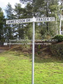 Eltham District Historical Society Inc
Photograph - Digital Photograph, Alan King, Site of the Diamond Creek Gold Mine, 28 December 2007
... tunnels once of central importance to the fledgling township of Diamond Creek. These are relics of gold mines, which transformed early Diamond Creek.1 The tiny settlement of about 20 families soared to more than 200 because of gold. For around 50 years, from 1862, gold mining...tunnels once of central importance to the fledgling township of Diamond Creek. These are relics of gold mines, which transformed early Diamond Creek.1 The tiny settlement of about 20 families soared to more than 200 because of gold. For around 50 years, from 1862, gold mining ...The largest gold mine in the area originated from a find in 1862. The mine was closed January 20, 1915 when a fire destroyed nearly all the above ground plant. Published: Nillumbik Now and Then / Marguerite Marshall 2008; photographs Alan King with Marguerite Marshall.; p75 Beneath Mine Hill, as locals call it, runs a network of tunnels once of central importance to the fledgling township of Diamond Creek. These are relics of gold mines, which transformed early Diamond Creek.1 The tiny settlement of about 20 families soared to more than 200 because of gold. For around 50 years, from 1862, gold mining was Diamond Creek’s major source of employment. On September 7, 1854 The Argus newspaper reported a find of a four pound (1.8kg) gold nugget in Nillumbik (an early name for Diamond Creek). Exactly where, is not known.2 The largest mine in the district, the Diamond Creek Gold Mine, apparently originated from a find in 1862. It is said Joe and Dave Wilson were visiting former tailor then cook, Charles Orme, at the southern end of Fraser Street. Sitting on a stump outside the front gate on land belonging to Dr A. E. Phipps the Wilsons found a vein of gold-bearing quartz, which led to the discovery of four quartz reefs varying in width to eight inches (20cm), running north and south. A reef found at the foot of the hill opposite Challenger Street became the Union Mine. This reef was traced south to Allendale Road where a small mine began operations.3 Other smaller mines later operated as well. Dr Phipps immediately began to mine and also built the Diamond Reef Hotel as a boarding house for miners. But Charles Orme, who owned the land alongside, leased his mine to Dr Phipps probably because of insufficient funds and business skills. By mid 1865 the mine had produced 2530 ounces of gold – a 100% profit on the original outlay. Of course there were problems. When the local dam dried up a Blake pump was installed to draw water from the creek. The Union Mine operated under the Diamond Creek Gold Mine management except when disputes sometimes resulted in separate management. However disagreements had to be resolved as the Union Mine depended on Diamond Creek Gold Mine pumps to remove underground water from common reefs. In 1912 the main shaft of about 380 yards (350m) employed 200 men recovering an average of 5000 ounces (141.7kg) of gold a year. But not everyone did well out of gold. Records of failed mining companies in the Victorian Public Record Office, reveal that owner Dr Phipps leased his Right to others. Companies came and went over the next 40 years, most sponsored by Melbourne businessmen who sold shares to gullible locals and then became insolvent. Although there were some good profits, financial returns were haphazard until 1905. Some local residents, who were share holders in short- term companies, became well-known names in modern Diamond Creek such as Scott, Haley, Butler, Alder, Ryan, Wadeson, Reeves, Alston, Paul and Edwards. Gold mining was brought to a disastrous end on January 20, 1915 at 3 pm, when fire destroyed nearly all the above-ground plant. Fortunately no lives were lost. But reopening the mine was almost impossible because of the increasing depth of water in the main shaft. The closed mine destroyed the livelihood of 200 families and the debris took many years to clear.4 In 1946 the Diamond Creek Gold Mine was reopened by the Golden Hind Mining Company, but money ran out before the 600 feet (182.8m) or so of water could be removed. Gold remains in the mine but enormous capital would be needed to buy the land, equipment and to remove the water. Today 12 known sealed shafts along the ridge of the hills on private property extend west for around one kilometre from the corner of Fraser and Haley Streets, crossing Norma and Fyffe to Dering Streets. As recently as 1987, heavy rains revealed a former Union Mine shaft in the Georgiadis family Fyffe Street back yard.5 Allendale Mine, south of Allendale Road, is still open and one of the Union Mine’s main drives (horizontal excavation) remains unsealed, on the Creek Reserve.This collection of almost 130 photos about places and people within the Shire of Nillumbik, an urban and rural municipality in Melbourne's north, contributes to an understanding of the history of the Shire. Published in 2008 immediately prior to the Black Saturday bushfires of February 7, 2009, it documents sites that were impacted, and in some cases destroyed by the fires. It includes photographs taken especially for the publication, creating a unique time capsule representing the Shire in the early 21st century. It remains the most recent comprehenesive publication devoted to the Shire's history connecting local residents to the past. nillumbik now and then (marshall-king) collection, diamond creek, diamond creek mine, fraser street, gold mining, james cook drive, mine hill -
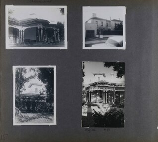
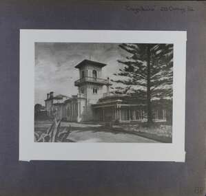
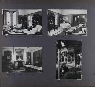
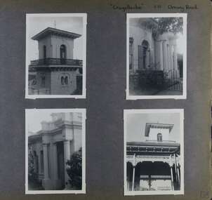 Glen Eira Historical Society
Album - Album page, Craigellachie, 273 Orrong Road, Circa 1972
... From Victorian Heritage Database citation for HO40 Craigellachie https://vhd.heritagecouncil.vic.gov.au/places/35209 as at (28/10/2020) It is historically significant (Criterion A) as the Melbourne home of William Pearson, MLA, MLC and principal shareholder in Walhalla's Long Tunnel Extended Gold Mining Co. which sustained the township well past the turn of the twentieth century and occupied fifth place amongst Victoria's richest mines. ...This photograph is part of the Caulfield Historical Album 1972. This album was created in approximately 1972 as part of a project by the Caulfield Historical Society to assist in identifying buildings worthy of preservation. The album is related to a Survey the Caulfield Historical Society developed in collaboration with the National Trust of Australia (Victoria) and Caulfield City Council to identify historic buildings within the City of Caulfield that warranted the protection of a National Trust Classification. Principal photographer thought to be Trevor Hart, member of Caulfield Historical Society. Most photographs were taken between 1966-1972 with a small number of photographs being older and from unknown sources. All photographs are black and white except where stated, with 386 photographs over 198 pages. From Victorian Heritage Database citation HO40 Craigellachie 2b & 2c Lynedoch Avenue Caulfield North https://vhd.heritagecouncil.vic.gov.au/places/35209 as at (28/10/2020) Craigellachie" is situated at No. 2B Lynedoch Avenue, Caulfield North, and was built for the noted investor, pastoralist and politician, William Pearson, not earlier than 1864 and possible in 1876, undergoing several substantial and contributory extensions during the nineteenth century. It is historically and aesthetically significant. From Victorian Heritage Database citation for HO40 Craigellachie https://vhd.heritagecouncil.vic.gov.au/places/35209 as at (28/10/2020) It is historically significant (Criterion A) as the Melbourne home of William Pearson, MLA, MLC and principal shareholder in Walhalla's Long Tunnel Extended Gold Mining Co. which sustained the township well past the turn of the twentieth century and occupied fifth place amongst Victoria's richest mines. It is aesthetically significant (Criterion E) for its capacity to demonstrate Pearson's continuing financial success throughout the mid to late nineteenth century, the additions associated with the tower being most noteworthy as an example of the lasting appeal of the Italian Style, popularized in the pattern books of the day. The Ailanthus altissima (Tree of Heaven) is significant as an outstanding example of a species that is rare in cultivation, as well as for its very high aesthetic value. The Araucaria bidwilli is notable as a fine example of a species infrequently planted in Melbourne and rarely found in private suburban gardens.Page 156 of Photograph Album with four landscape photographs of Craigellachie - near views of architectural features. Handwritten: "Craigellachie" 273 Orrong Road [top right] / 156 [bottom right]trevor hart, verandah, orrong road, tower, curved windows, decorative brackets, italianate, mansion, 1870's, william pearson, inkerman street, apartments, spire, decorative plaster work, rendered walls, ornamentation, arched windows, moulded ornaments, 1860's, lynedoch avenue, classical style, caulfield north, craigellachie, cast iron work, victorian style, balaclava, st kilda east, gardens, ailanthus altissima, araucaria bidwilli, porches, trees -
 Glen Eira Historical Society
Album - Album page, Craigellachie, 273 Orrong Road, Circa 1972
... From Victorian Heritage Database citation for HO40 Craigellachie https://vhd.heritagecouncil.vic.gov.au/places/35209 as at (28/10/2020) It is historically significant (Criterion A) as the Melbourne home of William Pearson, MLA, MLC and principal shareholder in Walhalla's Long Tunnel Extended Gold Mining Co. which sustained the township well past the turn of the twentieth century and occupied fifth place amongst Victoria's richest mines. ...This photograph is part of the Caulfield Historical Album 1972. This album was created in approximately 1972 as part of a project by the Caulfield Historical Society to assist in identifying buildings worthy of preservation. The album is related to a Survey the Caulfield Historical Society developed in collaboration with the National Trust of Australia (Victoria) and Caulfield City Council to identify historic buildings within the City of Caulfield that warranted the protection of a National Trust Classification. Principal photographer thought to be Trevor Hart, member of Caulfield Historical Society. Most photographs were taken between 1966-1972 with a small number of photographs being older and from unknown sources. All photographs are black and white except where stated, with 386 photographs over 198 pages. From Victorian Heritage Database citation for HO40 Craigellachie 2b & 2c Lynedoch Avenue Caulfield North https://vhd.heritagecouncil.vic.gov.au/places/35209 as at (28/10/2020) Craigellachie" is situated at No. 2B Lynedoch Avenue, Caulfield North, and was built for the noted investor, pastoralist and politician, William Pearson, not earlier than 1864 and possible in 1876, undergoing several substantial and contributory extensions during the nineteenth century. It is historically and aesthetically significant. From Victorian Heritage Database citation for HO40 Craigellachie https://vhd.heritagecouncil.vic.gov.au/places/35209 as at (28/10/2020) It is historically significant (Criterion A) as the Melbourne home of William Pearson, MLA, MLC and principal shareholder in Walhalla's Long Tunnel Extended Gold Mining Co. which sustained the township well past the turn of the twentieth century and occupied fifth place amongst Victoria's richest mines. It is aesthetically significant (Criterion E) for its capacity to demonstrate Pearson's continuing financial success throughout the mid to late nineteenth century, the additions associated with the tower being most noteworthy as an example of the lasting appeal of the Italian Style, popularized in the pattern books of the day. The Ailanthus altissima (Tree of Heaven) is significant as an outstanding example of a species that is rare in cultivation, as well as for its very high aesthetic value. The Araucaria bidwilli is notable as a fine example of a species infrequently planted in Melbourne and rarely found in private suburban gardens.Page 157 - four photographs of Craigellachie - exterior views. Handwritten: CRAIGELLACHIE [top left] / Neg 212 1973 [under bottom right photo] / 157 [bottom left]trevor hart, verandah, orrong road, tower, cast iron lacework, curved windows, decorative brackets, italianate, mansion, 1870's, william pearson, inkerman street, apartments, spire, decorative plaster work, rendered walls, arched windows, moulded ornaments, 1860's, lynedoch avenue, classical style, caulfield north, craigellachie, st kilda east, late victorian style, garages (private), gardens, cast iron work, ailanthus altissima, araucaria bidwilli, trees -
 Glen Eira Historical Society
Album - Album page, Craigellachie, 273 Orrong Road, Circa 1972
... From Victorian Heritage Database citation for HO40 Craigellachie https://vhd.heritagecouncil.vic.gov.au/places/35209 as at (28/10/2020) It is historically significant (Criterion A) as the Melbourne home of William Pearson, MLA, MLC and principal shareholder in Walhalla's Long Tunnel Extended Gold Mining Co. which sustained the township well past the turn of the twentieth century and occupied fifth place amongst Victoria's richest mines. ...This photograph is part of the Caulfield Historical Album 1972. This album was created in approximately 1972 as part of a project by the Caulfield Historical Society to assist in identifying buildings worthy of preservation. The album is related to a Survey the Caulfield Historical Society developed in collaboration with the National Trust of Australia (Victoria) and Caulfield City Council to identify historic buildings within the City of Caulfield that warranted the protection of a National Trust Classification. Principal photographer thought to be Trevor Hart, member of Caulfield Historical Society. Most photographs were taken between 1966-1972 with a small number of photographs being older and from unknown sources. All photographs are black and white except where stated, with 386 photographs over 198 pages. From Victorian Heritage Database citation for HO40 Craigellachie 2b & 2c Lynedoch Avenue Caulfield North https://vhd.heritagecouncil.vic.gov.au/places/35209 as at (28/10/2020) Craigellachie" is situated at No. 2B Lynedoch Avenue, Caulfield North, and was built for the noted investor, pastoralist and politician, William Pearson, not earlier than 1864 and possible in 1876, undergoing several substantial and contributory extensions during the nineteenth century. It is historically and aesthetically significant. From Victorian Heritage Database citation for HO40 Craigellachie https://vhd.heritagecouncil.vic.gov.au/places/35209 as at (28/10/2020) It is historically significant (Criterion A) as the Melbourne home of William Pearson, MLA, MLC and principal shareholder in Walhalla's Long Tunnel Extended Gold Mining Co. which sustained the township well past the turn of the twentieth century and occupied fifth place amongst Victoria's richest mines. It is aesthetically significant (Criterion E) for its capacity to demonstrate Pearson's continuing financial success throughout the mid to late nineteenth century, the additions associated with the tower being most noteworthy as an example of the lasting appeal of the Italian Style, popularized in the pattern books of the day. The Ailanthus altissima (Tree of Heaven) is significant as an outstanding example of a species that is rare in cultivation, as well as for its very high aesthetic value. The Araucaria bidwilli is notable as a fine example of a species infrequently planted in Melbourne and rarely found in private suburban gardens.Page 158 of Photograph Album with one image of Craigellachie's exterior. Handwritten: "Craigellachie" 273 Orrong Road [top right] / 158 [bottom right]trevor hart, verandah, orrong road, tower, curved windows, decorative brackets, rendered, craigellache, italianate, mansion, 1870's, william pearson, inkerman street, apartments, spire, decorative plaster work, rendered walls, ornamentation, arched windows, moulded ornaments, 1860's, lynedoch avenue, classical style, caulfield north, craigellachie, land subdivision, gardens, late victorian style, cast iron work, st kilda east, ailanthus altissima, araucaria bidwilli, trees -
 Glen Eira Historical Society
Album - Album page, Craigellachie, 273 Orrong Road, Circa 1972
... From Victorian Heritage Database citation for HO40 Craigellachie https://vhd.heritagecouncil.vic.gov.au/places/35209 as at (28/10/2020) It is historically significant (Criterion A) as the Melbourne home of William Pearson, MLA, MLC and principal shareholder in Walhalla's Long Tunnel Extended Gold Mining Co. which sustained the township well past the turn of the twentieth century and occupied fifth place amongst Victoria's richest mines. ...This photograph is part of the Caulfield Historical Album 1972. This album was created in approximately 1972 as part of a project by the Caulfield Historical Society to assist in identifying buildings worthy of preservation. The album is related to a Survey the Caulfield Historical Society developed in collaboration with the National Trust of Australia (Victoria) and Caulfield City Council to identify historic buildings within the City of Caulfield that warranted the protection of a National Trust Classification. Principal photographer thought to be Trevor Hart, member of Caulfield Historical Society. Most photographs were taken between 1966-1972 with a small number of photographs being older and from unknown sources. All photographs are black and white except where stated, with 386 photographs over 198 pages. From Victorian Heritage Database citation for HO40 Craigellachie 2b & 2c Lynedoch Avenue Caulfield North https://vhd.heritagecouncil.vic.gov.au/places/35209 as at (28/10/2020) Craigellachie" is situated at No. 2B Lynedoch Avenue, Caulfield North, and was built for the noted investor, pastoralist and politician, William Pearson, not earlier than 1864 and possible in 1876, undergoing several substantial and contributory extensions during the nineteenth century. It is historically and aesthetically significant. From Victorian Heritage Database citation for HO40 Craigellachie https://vhd.heritagecouncil.vic.gov.au/places/35209 as at (28/10/2020) It is historically significant (Criterion A) as the Melbourne home of William Pearson, MLA, MLC and principal shareholder in Walhalla's Long Tunnel Extended Gold Mining Co. which sustained the township well past the turn of the twentieth century and occupied fifth place amongst Victoria's richest mines. It is aesthetically significant (Criterion E) for its capacity to demonstrate Pearson's continuing financial success throughout the mid to late nineteenth century, the additions associated with the tower being most noteworthy as an example of the lasting appeal of the Italian Style, popularized in the pattern books of the day. The Ailanthus altissima (Tree of Heaven) is significant as an outstanding example of a species that is rare in cultivation, as well as for its very high aesthetic value. The Araucaria bidwilli is notable as a fine example of a species infrequently planted in Melbourne and rarely found in private suburban gardens.Page 159 - four photographs of Craigellachie - three room interiors and along the verandah. Handwritten: CRAIGELLACHIE [top left] / Neg 224 1973 CHINESE SITTING ROOM [under top right photo] / Neg 226 1973 / CHINESE SITTING ROOM [under top right photo] / Neg 214 1973 DINING ROOM [under bottom left photo] / Neg 213 - 1973 [under bottom right photo] / 159 [bottom left]trevor hart, verandah, orrong road, tower, curved windows, decorative brackets, craigellache, italianate, mansion, 1870's, william pearson, inkerman street, apartments, spire, decorative plaster work, rendered walls, arched windows, moulded ornaments, 1860's, lynedoch avenue, classical style, caulfield north, craigellachie, land subdivision, gardens, late victorian style, cast iron work, st kilda east, dining rooms, sitting rooms, furnishings, tiles -
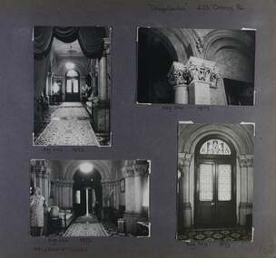 Glen Eira Historical Society
Album - Album page, Craigellachie, 273 Orrong Road, Circa 1972
... From Victorian Heritage Database citation for HO40 Craigellachie https://vhd.heritagecouncil.vic.gov.au/places/35209 as at (28/10/2020) It is historically significant (Criterion A) as the Melbourne home of William Pearson, MLA, MLC and principal shareholder in Walhalla's Long Tunnel Extended Gold Mining Co. which sustained the township well past the turn of the twentieth century and occupied fifth place amongst Victoria's richest mines. ...This photograph is part of the Caulfield Historical Album 1972. This album was created in approximately 1972 as part of a project by the Caulfield Historical Society to assist in identifying buildings worthy of preservation. The album is related to a Survey the Caulfield Historical Society developed in collaboration with the National Trust of Australia (Victoria) and Caulfield City Council to identify historic buildings within the City of Caulfield that warranted the protection of a National Trust Classification. Principal photographer thought to be Trevor Hart, member of Caulfield Historical Society. Most photographs were taken between 1966-1972 with a small number of photographs being older and from unknown sources. All photographs are black and white except where stated, with 386 photographs over 198 pages. From Victorian Heritage Database citation for HO40 Craigellachie 2b & 2c Lynedoch Avenue Caulfield North https://vhd.heritagecouncil.vic.gov.au/places/35209 as at (28/10/2020) Craigellachie" is situated at No. 2B Lynedoch Avenue, Caulfield North, and was built for the noted investor, pastoralist and politician, William Pearson, not earlier than 1864 and possible in 1876, undergoing several substantial and contributory extensions during the nineteenth century. It is historically and aesthetically significant.From Victorian Heritage Database citation for HO40 Craigellachie https://vhd.heritagecouncil.vic.gov.au/places/35209 as at (28/10/2020) It is historically significant (Criterion A) as the Melbourne home of William Pearson, MLA, MLC and principal shareholder in Walhalla's Long Tunnel Extended Gold Mining Co. which sustained the township well past the turn of the twentieth century and occupied fifth place amongst Victoria's richest mines. It is aesthetically significant (Criterion E) for its capacity to demonstrate Pearson's continuing financial success throughout the mid to late nineteenth century, the additions associated with the tower being most noteworthy as an example of the lasting appeal of the Italian Style, popularized in the pattern books of the day. The Ailanthus altissima (Tree of Heaven) is significant as an outstanding example of a species that is rare in cultivation, as well as for its very high aesthetic value. The Araucaria bidwilli is notable as a fine example of a species infrequently planted in Melbourne and rarely found in private suburban gardens.Page 160 - four photographs of Craigellachie interiors. Handwritten: "Craigellachie" 273 Orrong Road [top right] / 156 [bottom right]trevor hart, orrong road, italianate, mansion, 1870's, william pearson, inkerman street, decorative plaster work, rendered walls, ornamentation, moulded ornaments, 1860's, lynedoch avenue, classical style, caulfield north, craigellachie, late victorian style, st kilda east, hallways, arched doors, stained glass, mrs francis, furnishings -
 Glen Eira Historical Society
Album - Album page, Craigellachie, 273 Orrong Road, Circa 1972
... From Victorian Heritage Database citation for HO40 Craigellachie https://vhd.heritagecouncil.vic.gov.au/places/35209 as at (28/10/2020) It is historically significant (Criterion A) as the Melbourne home of William Pearson, MLA, MLC and principal shareholder in Walhalla's Long Tunnel Extended Gold Mining Co. which sustained the township well past the turn of the twentieth century and occupied fifth place amongst Victoria's richest mines. ...This photograph is part of the Caulfield Historical Album 1972. This album was created in approximately 1972 as part of a project by the Caulfield Historical Society to assist in identifying buildings worthy of preservation. The album is related to a Survey the Caulfield Historical Society developed in collaboration with the National Trust of Australia (Victoria) and Caulfield City Council to identify historic buildings within the City of Caulfield that warranted the protection of a National Trust Classification. Principal photographer thought to be Trevor Hart, member of Caulfield Historical Society. Most photographs were taken between 1966-1972 with a small number of photographs being older and from unknown sources. All photographs are black and white except where stated, with 386 photographs over 198 pages. From Victorian Heritage Database citation for HO40 Craigellachie 2b & 2c Lynedoch Avenue Caulfield North https://vhd.heritagecouncil.vic.gov.au/places/35209 as at (28/10/2020) Craigellachie" is situated at No. 2B Lynedoch Avenue, Caulfield North, and was built for the noted investor, pastoralist and politician, William Pearson, not earlier than 1864 and possible in 1876, undergoing several substantial and contributory extensions during the nineteenth century. It is historically and aesthetically significant. From Victorian Heritage Database citation for HO40 Craigellachie https://vhd.heritagecouncil.vic.gov.au/places/35209 as at (28/10/2020) It is historically significant (Criterion A) as the Melbourne home of William Pearson, MLA, MLC and principal shareholder in Walhalla's Long Tunnel Extended Gold Mining Co. which sustained the township well past the turn of the twentieth century and occupied fifth place amongst Victoria's richest mines. It is aesthetically significant (Criterion E) for its capacity to demonstrate Pearson's continuing financial success throughout the mid to late nineteenth century, the additions associated with the tower being most noteworthy as an example of the lasting appeal of the Italian Style, popularized in the pattern books of the day. The Ailanthus altissima (Tree of Heaven) is significant as an outstanding example of a species that is rare in cultivation, as well as for its very high aesthetic value. The Araucaria bidwilli is notable as a fine example of a species infrequently planted in Melbourne and rarely found in private suburban gardens.Page 161 - four photographs of Craigellachie dining room Handwritten: CRAIGELLACHIE DINING ROOM [top left] / Neg 218 1973 [under top left photo] / Neg 217 - 1973 [under top right photo] / Neg 216- 1973 [under bottom left photo] / Neg 215 1973 [under bottom right photo] / 161 [bottom left]trevor hart, orrong road, curved windows, italianate, mansion, 1870's, william pearson, inkerman street, decorative plaster work, rendered walls, moulded ornaments, 1860's, lynedoch avenue, classical style, caulfield north, craigellachie, land subdivision, late victorian style, dining rooms, ceiling roses, furnishings, fireplaces, st kilda east -
Glen Eira Historical Society
Article - Pearson, William
... ... Long Tunnel Gold Mining Co....Pearson William ‘Craigellachie’ ‘Kilmany Park’ Housenames Pioneers Travers Eliza Laura Orrong Rd Magistrate Studs Mine owners Mansion Long Tunnel Gold Mining Co. Pearson Hugh Pearson Henry Travers Pearson William jr Inkerman Street Article Pearson, William ...Four items related to Pearson family. 1.Brief photocopied item giving details relating to William’s pastoral estates. Political arenas he was involved with his business interests including his breeding of race horses, including handwritten note about his champion racehorse, date and author unknown. 2.Handwritten page on the details of his family burial plots at Brighton cemetery, date and author unknown. 3.Handwritten rate book listings from 1876 to 1891, date and source unknown. 4.3 copies of Heraldic sketches pertaining to the Pearson of Kilmany Park and Craigellachie in Scotland.pearson william, ‘craigellachie’, ‘kilmany park’, housenames, pioneers, travers eliza laura, orrong rd, magistrate, studs, mine owners, mansion, long tunnel gold mining co., pearson hugh, pearson henry travers, pearson william jr, inkerman street -
 The Beechworth Burke Museum
Photograph - Photograph - Reproduction, c.1870s
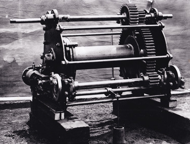
... Today, the 800ft tunnel, completed in 1871, is a popular tourist attraction but during the decades of gold mining, the purpose of this tunnel was to divert water away from the main sluicing operations so miners could better access gold and precious materials. ...Today, the 800ft tunnel, completed in 1871, is a popular tourist attraction but during the decades of gold mining, the purpose of this tunnel was to divert water away from the main sluicing operations so miners could better access gold and precious materials. ...This photograph shows a piece of gold mining equipment identified as a mine winch, possibly an air winch cylinder of 1870s RG Ford's Patent design. Throughout the history of mining for gold and other precious materials, the windlass or winch (pictured) was used to bring up buckets full of soil from the bottom of a mine. This soil was then searched for gold/metals before being relocated to a different area. Due to the size and complexity of this particular piece of equipment, this winch may have been used to raise and lower mine carts to the entrance of the mine (often used in coal mining) and could have been used in raising cages up and down (acting as elevators) containing miners if the mine was particularly deep. The actual use of this particular item in the Beechworth locality is undocumented but these are some possibilities based on the use of these pieces of equipment in other mining locations. Mining can have a largely detrimental impact to the environment and therefore, the study of machinery like the one depicted in this photograph can help researches to reconstruct the methods and technologies used in the late 1800s and early 1900s. This particular item appears to have been removed from it's original site where it would have been used to assist with mining. It is possible that this photograph has been taken for recording purposes or as part of a machinery exhibition. Prior documentation records that this piece of equipment had connections to the Rocky Mountains Mining Company. Today, the Rocky Mountains Gold Mining company is famous in Beechworth for having been instrumental in the creation of the Rocky Mountain tunnel. Construction for this tunnel began in 1859 when a group of 12 men blasted a 400ft long tailrace though the rock beneath the town of Beechworth. Today, the 800ft tunnel, completed in 1871, is a popular tourist attraction but during the decades of gold mining, the purpose of this tunnel was to divert water away from the main sluicing operations so miners could better access gold and precious materials. The tunnel was used for this purpose for many years, later becoming useful for the Zwar Brother's tannery and currently as an outfall drain for Lake Sambell. This area continued to be mined until the early 1900s. The period when this item was in use is unclear but it is estimated to have been in the 1870s based on the design and appearance of the image. The gold works at the Rocky Mountain Tunnel closed in the early 1920s but the impact of mining remains in Beechworth today and therefore the study of photographs like this one which contain mining equipment can further understanding of mining in this region.This photograph has historic and research potential for study on the gold mining of the Beechworth region and types of equipment used to locate gold after the initial gold rush of 1853-1854 which resulted in the discovery of the surface gold and required miners to dig deeper to access precious metals. The clarity of the photo, and its good preserved condition, means it can continue to be used for research. This photo is part of a collection of six photos all within the Burke Museum Collection which depict mining equipment.Square black and white photograph on card.7793.1beechworth, mining, goldmining, goldmining equipment, beechworth burke museum -
 The Beechworth Burke Museum
Photograph
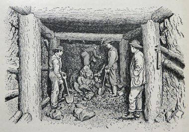
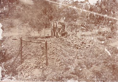
... Mr Williams senior worked on various mining activities in the district, including the Rocky Mountain Tunnel project. ...Mr Williams senior worked on various mining activities in the district, including the Rocky Mountain Tunnel project. ...This image is a reproduction of an 1899 original depicting the 'Williams Good Luck Mine' on the Mopoke Reef (also called 'Morepork Gully') in the Dingle Ranges, approximately three miles from Beechworth. A large opening to a mine can be seen behind the men in the photograph, with a wheeled cart on a track leading to the men's position, where the soil and rocks have been hauled away. This photograph interestingly contains dogs alongside the miners. While dogs have been recorded as deterrents to thieves in the Victorian goldfields, these dogs appear as companions to these men. Following the discovery of gold at Beechworth in 1852, rushes quickly followed at surrounding creeks and gullies in the district. In the late nineteenth and early twentieth centuries, small syndicates of miners continued to work old or abandoned quartz reefs, often persisting without the assistance of heavy machinery to remove the large amounts of rock, in order to obtain yields at ever greater depths. The group of miners in this photograph are Mr. Roger Williams and Sons, who revived operations at the ‘Old Good Luck’ mine on the Mopoke Reef in the Dingle Range near Beechworth around 1892, working the site for more than two decades. An emigrant from Cornwall with experience in the tin mining industry, 19 year old Roger Williams senior sailed to New Zealand in 1840, then to Australia where he spent time in the Bendigo Gold Fields before settling in Beechworth in the early 1860s. Mr Williams senior worked on various mining activities in the district, including the Rocky Mountain Tunnel project. Conversant with the character of gold-bearing reefs in the area, the syndicate dug an eight hundred foot tunnel, digging down as far down as two hundred feet with little capital save their labour, to connect and provide better working access to the mass of reefs and veins in the vicinity. Progress was hampered by poor air quality charged with fumes from dynamite and large quantities of rock had to be crushed to obtain payable yields. The Victorian Goldfields are filled with ruins and remnants of the area's rich mining history, ranging from small alluvial diggings to the remains of huge mining companies. Site names often changed several times throughout the nineteenth and twentieth centuries. Some sites were abandoned and forgotten, others were worked continuously over many decades. The names of mines were often repeated at different locations throughout the Victorian Goldfields. For example, there is a Mopoke Gully heritage mine near Fryers Creek, Victoria. 'Mopoke' is a common onomatopoeic name for Morepork and Australian Boobook owls.This image has historical, social and research significance for patterns of emigration during of the Victorian Gold Rush, and the historical, social and environmental impacts of mining at Beechworth at the turn of the nineteenth and twentieth centuries. As gold became scarce and government support and large company investment waned, poor hard-working miners laboured intensively to make a living through periods of high unemployment. This image can be compared and studied alongside other historical mining photographs and objects in the Burke Museum Collection. It has potential to improve our understanding of miners working conditions and the shifting character of mining in the Beechworth district.Sepia coloured rectangular photograph printed on gloss photographic paper mounted on card. Obverse: Williams/ Good/ Luck Reverse: A02498/ 1997. 2498/ Good Luck/ Mine/ 1899/ Mopoke. burke museum, beechworth museum, beechworth, gold fields, gold rush, victorian gold rush, gold ming history, colonial australia, australian gold rushes, mining technology, beechworth historic district, indigo gold trail, migration, indigo shire, good luck gold mine, victorian goldfields, mining syndicates, gold fever, quartz-mining, small-scale mining, old good luck mine, mopoke gully, quartz reefs beechworth -
 The Beechworth Burke Museum
Photograph
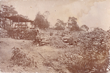
... Mr Williams senior worked on various mining activities in the district, including the Rocky Mountain Tunnel project. ...Mr Williams senior worked on various mining activities in the district, including the Rocky Mountain Tunnel project. ...This image is a reproduction of an 1899 original depicting the 'Williams Good Luck Mine' on the Mopoke Reef (also called 'Morepork Gully') in the Dingle Ranges, approximately three miles from Beechworth. The foreground of the image is littered with piles of smashed rock and detritus, known as ‘mullock’, beside a reinforced mine shaft, a vertical access passageway allowing miners to enter the mine and haul ore out using lifting technology such as a poppet heads, whims or windlasses. A group of miners and a dog appear close to an open-sided miner’s hut. Following the discovery of gold at Beechworth in 1852, rushes quickly followed at surrounding creeks and gullies in the district. In the late nineteenth and early twentieth centuries, small syndicates of miners continued to work old or abandoned quartz reefs, often persisting without the assistance of heavy machinery to remove the large amounts of rock, in order to obtain yields at ever greater depths. The group of miners in this photograph are Mr. Roger Williams and Sons, who revived operations at the ‘Old Good Luck’ mine on the Mopoke Reef in the Dingle Range near Beechworth around 1892, working the site for more than two decades. An emigrant from Cornwall with experience in the tin mining industry, 19 year old Roger Williams senior sailed to New Zealand in 1840, then to Australia where he spent time in the Bendigo Gold Fields before settling in Beechworth in the early 1860s. Mr Williams senior worked on various mining activities in the district, including the Rocky Mountain Tunnel project. Conversant with the character of gold-bearing reefs in the area, the syndicate dug an eight hundred foot tunnel, digging down as far down as two hundred feet with little capital save their labour, to connect and provide better working access to the mass of reefs and veins in the vicinity. Progress was hampered by poor air quality charged with fumes from dynamite and large quantities of rock had to be crushed to obtain payable yields. The Victorian Goldfields are filled with ruins and remnants of the area's rich mining history, ranging from small alluvial diggings to the remains of huge mining companies. Site names often changed several times throughout the nineteenth and twentieth centuries. Some sites were abandoned and forgotten, others were worked continuously over many decades. The names of mines were often repeated at different locations throughout the Victorian Goldfields. For example, there is a Mopoke Gully heritage mine near Fryers Creek, Victoria. 'Mopoke' is a common onomatopoeic name for Morepork and Australian Boobook owls.This image has historical, social and research significance for patterns of emigration during of the Victorian Gold Rush, and the historical, social and environmental impacts of mining at Beechworth at the turn of the nineteenth and twentieth centuries. As gold became scarce and government support and large company investment waned, poor hard-working miners laboured intensively to make a living through periods of high unemployment. This image can be compared and studied alongside other historical mining photographs and objects in the Burke Museum Collection. It has potential to improve our understanding of miners working conditions and the shifting character of mining in the Beechworth district.Sepia coloured rectangular photograph printed on gloss photographic paper mounted on card.Obverse: Reverse: A02497/ 1997.2497/ 'Good/ Luck/ Mine'/ Morepork/ Gully/ Mrs Joyce/ Bright/ Tunnel/ 800 ft/ 1899. burke museum, beechworth museum, beechworth, gold fields, gold rush, victorian gold rush, gold ming history, colonial australia, australian gold rushes, mining technology, beechworth historic district, indigo gold trail, migration, indigo shire, good luck gold mine, victorian goldfields, mining syndicates, gold fever, quartz-mining, small-scale mining, old good luck mine, mopoke gully, quartz reefs beechworth -
 The Beechworth Burke Museum
Photograph - Photograph - Reproduction, 1890-1900
... This tunnel drained the excess water from the upper Spring Creek Goldfield to allow for mining access in the area. ...This tunnel drained the excess water from the upper Spring Creek Goldfield to allow for mining access in the area. ...The photograph appears to depict the of the entrance to the Rocky Mountain Tunnel. The Rocky Mountain Tunnel runs from opening of the tunnel, underneath the Beechworth town, to the Gorge. This tunnel drained the excess water from the upper Spring Creek Goldfield to allow for mining access in the area. The Rocky Mountain Co. blasted through the granite rock to create the original 400ft-long tunnel in 1859, but between 1867 and 1871, the Rocky Mountain Gold Sluicing Co. widened and extended it. At its completion, it measured 14ft deep, 6ft wide, and almost half a mile long. The mining surveyor at Beechworth called it 'without doubt, the greatest undertaking of the kind in the colony'. When the company became the Rocky Mountain Extended Gold Sluicing Co. in the mid-1870s, they continued the tunnelling work. The work was reportedly vital to mining being able to continue at Beechworth and may have established world records in tunnelling through hard rock. The entrance at the Gorge side of the tunnel can be seen from the Beechworth Gorge Walk. The tunnel continues to be an outfall drain for the lake and the town.The search for gold is ingrained into the history of Victoria and therefore, images like this one which portray an open cut sluicing site can reveal important information for society and technology for the date when the photograph was taken. This image is of important historical significance for its ability to convey information about sluicing and the methods used to find gold in the late 1800s and early 1900s. It also shows a location where sluicing was undertook which provides insight into the impact of sluicing on the environment at a time when it was done. The Burke Museum is home to a substantial collection of Australian mining photographs which can be used to gain a deeper understanding into life on the gold fields, technology used in mining, the miners themselves and the impact of the gold digging on the environment.A black and white rectangular reproduced photograph printed on matte photographic paper.7814beechworth, beechworth museum, burke museum, australian museum, mining, rocky mountain mining co., rocky mountain mining company, mine, mining company, rocky mountain mine, mine entrance, rocky mountain, gold, gold mining -
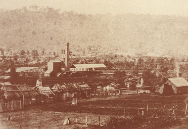 The Beechworth Burke Museum
Photograph, est. 1860-1875
... The tunnel was a true accomplishment both in the present and during the 19th century. It was considered to be a marvelous engineering feat. Beechworth is renowned for its hydraulic sluice method of mining. ...Mining Company. This extensive complex, of which nothing remains, was situated between Silver Creek and the present Lake Sambell area. The company was responsible for a tunnel...This image of the Rocky Mountain mine is historically significant as the mining complex is now non-existent, with the only remains being the tunnel built in 1880 by the company, which was considered one of the greatest engineering feats of the time. ...In 1875, the Rocky Mountain Extended Gold Sluicing Company Ltd was created, utilising the previous Rocky Mountain claim for the area near Lake Sambell. The company employed A.L Martin to survey an area for a tunnel underneath Beechworth and Johnson Stephens to dig it. The tunnel was built at a rate of 40 feet a month and eventually measured 800 metres. The tunnel was a true accomplishment both in the present and during the 19th century. It was considered to be a marvelous engineering feat. Beechworth is renowned for its hydraulic sluice method of mining. This involved soil being exposed to torrents of water from high-pressure hoses. From 1876 until its closure in 1921, the mine produced an astounding 47,926 ozs of gold. Companies like this were the source of income for many Chinese gold-diggers who sought to make their fortune on the goldfields of Beechworth. During the height of the rush, the town had around 7,000 Chinese inhabitants living on the outskirts of town as they were not permitted to live within Beechworth itself.The search for gold is ingrained into the history of Victoria and therefore, images like this one which portrays an open-cut sluicing site can reveal important information for society and technology for the date when the photograph was taken. This image is of important historical significance for its ability to convey information about sluicing and the methods used to find gold in 1910. It also shows a location where sluicing was undertaken which provides insight into the impact of sluicing on the environment at a time when it was done. This image of the Rocky Mountain mine is historically significant as the mining complex is now non-existent, with the only remains being the tunnel built in 1880 by the company, which was considered one of the greatest engineering feats of the time. The image also provides a first-hand look into the social and cultural networks at play during the 19th century with racial segregation of the Chinese at the 'Chinese Camp', as well as an insight into Beechworth's origins during the Gold Rush.A sepia rectangular photograph printed on matte photographic paper as a postcardReverse: Historic Beechworth / 7792.1 / ROCKY MOUNTAIN MINE / Viewed from the “Chinese Camp”, shown partly in the foreground, we see the central plant of the famous Rocky Mountain Mining Company. This extensive complex, of which nothing remains, was situated between Silver Creek and the present Lake Sambell area. The company was responsible for a tunnel cut through solid bedrock underneath the town of Beechworth and surfacing near the keystone bridge on the Wangaratta side. Completed in 1880 it was declared to be one of the greatest engineering feats in Australia. The tunnel is still basically intact today. / Series by Wooragee Graphics: Historic Beechworth. / COPYRIGHT BURKE MUSEUM / No.72 beechworth, rocky mountain mine, sluicing, gold rush, mining, gold