Showing 7 items matching "monnington"
-
 Kew Historical Society Inc
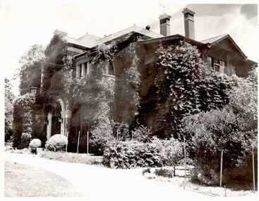
Photograph, 'Monnington', Adeney Avenue, Kew, c. 1960
... 'Monnington', Adeney Avenue, Kew...monnington...Monnington in Adeney Avenue was built by James Griffiths in 1886. ..."Monnington. James Griffiths House."..."Monnington. James Griffiths House." Monnington in Adeney Avenue was built by James Griffiths in 1886. ...This work forms part of the collection assembled by the historian Dorothy Rogers, that was donated to the Kew Historical Society by her son John Rogers in 2015. The manuscripts, photographs, maps, and documents were sourced by her from both family and local collections or produced as references for her print publications. Many were directly used by Rogers in writing ‘Lovely Old Homes of Kew’ (1961) and 'A History of Kew' (1973), or the numerous articles on local history that she produced for suburban newspapers. Most of the photographs in the collection include detailed annotations in her hand. The Rogers Collection provides a comprehensive insight into the working habits of a historian in the 1960s and 1970s. Together it forms the largest privately-donated collection within the archives of the Kew Historical Society.Monnington in Adeney Avenue was built by James Griffiths in 1886. His family lived there till about 1917."Monnington. James Griffiths House."monnington, james griffiths, adeney avenue -- kew (vic.) -
 Kew Historical Society Inc
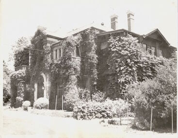
Photograph, 'Monnington', Adeney Avenue, Kew, 1950-1965
... 'Monnington', Adeney Avenue, Kew...monnington...Monnington. James Griffiths house...Together it forms the largest privately-donated collection within the archives of the Kew Historical Society. monnington kew dorothy rogers adeney avenue Monnington. ...This work forms part of the collection assembled by the historian Dorothy Rogers, that was donated to the Kew Historical Society by her son John Rogers in 2015. The manuscripts, photographs, maps, and documents were sourced by her from both family and local collections or produced as references for her print publications. Many were directly used by Rogers in writing ‘Lovely Old Homes of Kew’ (1961) and 'A History of Kew' (1973), or the numerous articles on local history that she produced for suburban newspapers. Most of the photographs in the collection include detailed annotations in her hand. The Rogers Collection provides a comprehensive insight into the working habits of a historian in the 1960s and 1970s. Together it forms the largest privately-donated collection within the archives of the Kew Historical Society.Front of Mornington in Adeney Avenue, Kew.Monnington. James Griffiths housemonnington, kew, dorothy rogers, adeney avenue -
![Monnington [Estate], 1935](/media/collectors/550653872162f11fb04854aa/items/5907eb86d0ce0c14e82385c8/item-media/5907ecafd0ce0c14e823e87f/item-fit-380x285.jpg?cb=6) Kew Historical Society Inc
Kew Historical Society IncPlan - Subdivision Plan, Monnington [Estate], 1935, 1935
... Monnington [Estate], 1935...The first subdivision of Monnington took place in 1935. At that time, Monnington and 10 new allotments were offered for sale bordering Adeney and Marshall Avenues. ...In this subdivision plan, Monnington is one of 13 lots for sale. The subdivision created the irregular land holding of Monnington today. ...Pru Sanderson, in her groundbreaking ‘City of Kew Urban Conservation Study : Volume 2 - Development History’ (1988), summarised the periods of urban development and subdivisions of land in Kew. The periods that she identified included 1845-1880, 1880-1893, 1893-1921, 1921-1933, 1933-1943, and Post-War Development. These periods were selected as they represented periods of rapid growth or decline in urban development. An obvious starting point for Sanderson’s groupings involved population growth and the associated economic cycles. These cycles also highlighted urban expansion onto land that was predominantly rural, although in other cases it represented the decline and breakup of large estates. A number of the plans in the Kew Historical Society’s collection can also be found in other collections, such as those of the State Library of Victoria and the Boroondara Library Service. A number are however unique to the collection.Subdivision plans are historically important documents used as evidence of the growth of suburbs in Australia. They frequently provide information about when the land was sold on which a built structure was subsequently constructed as well as evidence relating to surveyors and real estate and financial agents. The numerous subdivision plans in the Kew Historical Society's collection represent working documents, ranging from the initial sketches made in planning a subdivision to printed plans on which auctioneers or agents listed the prices for which individual lots were sold. In a number of cases, the reverse of a subdivision plan in the collection includes a photograph of a house that was also for sale by the agent. These photographs provide significant heritage information relating house design and decoration, fencing and household gardens.The first subdivision of Monnington took place in 1935. At that time, Monnington and 10 new allotments were offered for sale bordering Adeney and Marshall Avenues. In this subdivision plan, Monnington is one of 13 lots for sale. The subdivision created the irregular land holding of Monnington today. The excision of southwest corner of Monninton was caused by the need to have regular allotments facing the curve in Marshall Avenue.monnington - adeney avenue -- kew (vic.), subdivision plans -- kew (vic.) -
 Kew Historical Society Inc
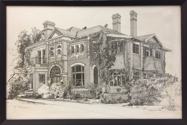
Print - 'Monnington', Adeney Avenue, Trompf, 1977
... In the mid 1960s, the Monnington Special Education Centre was established at 15 Adeney Avenue as an offshoot to 'Glendonald' in Marshall Avenue. ...This limited and numbered print [number 10/100], framed under perspex, is of Monnington in Adeney Avenue, Kew when it functioned as a Special Education Centre for deaf/blind children during the 1960s to the 1990s. . ..."Monnington Special Ed. Centre / 60s-90s / (Parent Guidance for Deaf/Blind Ch. / Adeney Ave, Kew / Murray Osler / Principal 76-80s"...Print 'Monnington', Adeney Avenue Trompf ...In the mid 1960s, the Monnington Special Education Centre was established at 15 Adeney Avenue as an offshoot to 'Glendonald' in Marshall Avenue. In 1988, the amalgamation of Princess Elizabeth Junior School for Deaf Children, the Monnington Centre and Carronbank School for Deaf Blind Students allowed the Victorian Government to sell each of the sites. Monnington [Adeney Avenue, Kew] reverted to private ownership, while Glendonald and Carronbank in Marshall Avenue were demolished and subdivided. The donor, Mr Murray Osler, was Principal of the Monnington Special Education Centre in Adeney Avenue (Kew) from 1976. This photo, and an accompanying drawing of 'Carronbank' are important primary resources for the history of the delivery of education to and for deaf-blind children in Victoria.Gift of Murray Osler, 2021This limited and numbered print [number 10/100], framed under perspex, is of Monnington in Adeney Avenue, Kew when it functioned as a Special Education Centre for deaf/blind children during the 1960s to the 1990s. . "Monnington Special Ed. Centre / 60s-90s / (Parent Guidance for Deaf/Blind Ch. / Adeney Ave, Kew / Murray Osler / Principal 76-80s"schools -- kew (vic.), mornington -- adeney avenue -
 Kew Historical Society Inc
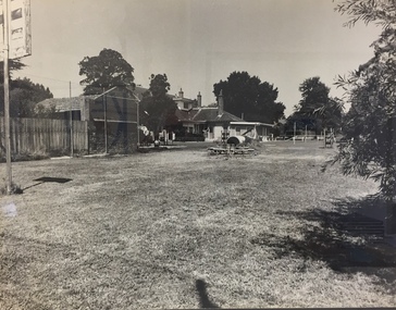
Photograph - 'Carronbank', Marshall Avenue, 1980s
... Monnington [Adeney Avenue, Kew] reverted to private ownership, while Glendonald and Carronbank in Marshall Avenue were demolished and subdivided....The donor, Mr Murray Osler, was Principal of the Monnington Special Education Centre in Adeney Avenue (Kew) from 1976. ...Carronbank (demolished) in Marshall Avenue, Kew was once the home of the Rev Graham Henty Balfour. It had extensive grounds, including a tennis court at the rear of the property. It remained a private residence until c.1960. The Department of Education purchased Carronbank as a school for partially sighted children, opening in February 1961 as State School No 4483. During the period 1961 to c.1980, the building housed a number of services. From 1969 to 1974, it was the site of Carronbank State School, later renamed Carronbank School for Deaf-Blind Children. In 1973, the Department established the Visiting Teacher Service for the Visually Impaired at the site. Its aim was to support teachers working in Victorian Government, Catholic and Independent Schools. From 1983 the school operated as Statewide Resource Centre for Visiting Teachers of the Vision Impaired. In 1988, the amalgamation of Princess Elizabeth Junior School for Deaf Children, the Monnington Centre and Carronbank School for Deaf Blind Students allowed the Victorian Government to sell each of the sites. Monnington [Adeney Avenue, Kew] reverted to private ownership, while Glendonald and Carronbank in Marshall Avenue were demolished and subdivided.The donor, Mr Murray Osler, was Principal of the Monnington Special Education Centre in Adeney Avenue (Kew) from 1976. This photo, and an accompanying drawing of 'Monnington' are important primary resources for the delivery of education to and for deaf-blind children in Victoria.The photograph, framed under perspex, shows the tennis court of Carronbank which had been converted into a play area for the students of the school. The flat roofed building may have been a toilet block, added for the school. The garage brick wall belongs to No 11. Grass is growing on the original asphalt court and there is equipment and tunnels for play. When sold the property was divided into three separate building blocks.carronbank -- marshall avenue -- kew (vic.), schools -- kew (vic.), carronbank -
 Kew Historical Society Inc
Archive (Sub-series) - Subject File, Buildings (Kew), 1964
... In addition to this correspondence, the file includes brief undated research notes on the Clock Tower at the Kew Cemetery, Tarring, Southesk, the Alexandra Gardens, Studley House (Burke Hall), Ellesmore, the Masonic Hall, Xavier College, Genazzano, Trinity Grammar, Carey Baptist College, Abbotsford, Fernhurst, Illapa, Madford, Morganville, Otira, Parkhill, Monnington, Field Place, Lalla Rookh, Merridale, Kew Mental Hospital, and D’Estaville....In addition to this correspondence, the file includes brief undated research notes on the Clock Tower at the Kew Cemetery, Tarring, Southesk, the Alexandra Gardens, Studley House (Burke Hall), Ellesmore, the Masonic Hall, Xavier College, Genazzano, Trinity Grammar, Carey Baptist College, Abbotsford, Fernhurst, Illapa, Madford, Morganville, Otira, Parkhill, Monnington, Field Place, Lalla Rookh, Merridale, Kew Mental Hospital, and D’Estaville. ...Various partiesReference, Research, InformationSecondary Values (KHS Imposed Order)Subject file containing newspaper articles/clippings, research and correspondence from and to the Society. The earliest item, dating from 1964 is a letter from the Society to the City of Kew seeking Council support for the use of Ellesmore, 80 Princess Street as a cultural heritage centre. Other items of correspondence relate to the Masonic Hall (Walpole Street), Fernhurst, Southesk, Roberts House, Park Hill, Butleigh Wooton, Villa Alba, D’Estaville, Charleville, Roseneath, Merridale, La Verna, Otira, Raheen, Willsmere, Holy Trinity Church. Some of these letters contain information about construction of the buildings and architects. In addition to this correspondence, the file includes brief undated research notes on the Clock Tower at the Kew Cemetery, Tarring, Southesk, the Alexandra Gardens, Studley House (Burke Hall), Ellesmore, the Masonic Hall, Xavier College, Genazzano, Trinity Grammar, Carey Baptist College, Abbotsford, Fernhurst, Illapa, Madford, Morganville, Otira, Parkhill, Monnington, Field Place, Lalla Rookh, Merridale, Kew Mental Hospital, and D’Estaville.buildings -- kew (vic.), heritage -- kew (vic.)buildings -- kew (vic.), heritage -- kew (vic.) -
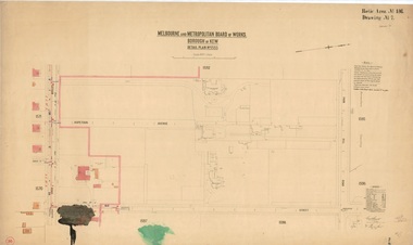 Kew Historical Society Inc
Plan, Melbourne & Metropolitan Board of Works / Borough of Kew, Detail Plan No.1593, 1905
... This included sewering on both sides of this part of Cotham Road, but excluded properties such as ‘Glendonald’ and ‘Monnington’. This area was to undergo a series of subdivisions including the ‘Clifton Estate’, which created housing lots on Adeney Avenue and Florence Avenue in 1916. ...This included sewering on both sides of this part of Cotham Road, but excluded properties such as ‘Glendonald’ and ‘Monnington’. This area was to undergo a series of subdivisions including the ‘Clifton Estate’, which created housing lots on Adeney Avenue and Florence Avenue in 1916. ...The Melbourne and Metropolitan Board of Works (MMBW) plans were produced from the 1890s to the 1950s. They were crucial to the design and development of Melbourne's sewerage and drainage system. The plans, at a scale of 40 feet to 1 inch (1:480), provide a detailed historical record of Melbourne streetscapes and environmental features. Each plan covers one or two street blocks (roughly six streets), showing details of buildings, including garden layouts and ownership boundaries, and features such as laneways, drains, bridges, parks, municipal boundaries and other prominent landmarks as they existed at the time each plan was produced. (Source: State Library of Victoria)This plan forms part of a large group of MMBW plans and maps that was donated to the Society by the Mr Poulter, City Engineer of the City of Kew in 1989. Within this collection, thirty-five hand-coloured plans, backed with linen, are of statewide significance as they include annotations that provide details of construction materials used in buildings in the first decade of the 20th century as well as additional information about land ownership and usage. The copies in the Public Record Office Victoria and the State Library of Victoria are monochrome versions which do not denote building materials so that the maps in this collection are invaluable and unique tools for researchers and heritage consultants. A number of the plans are not held in the collection of the State Library of Victoria so they have the additional attribute of rarity.Original survey plan, issued by the MMBW to a contractor with responsibility for constructing sewers in the area identified on the plan within the Borough of Kew. The plan was at some stage hand-coloured, possibly by the contractor, but more likely by officers working in the Engineering Department of the Borough and later Town, then City of Kew. The hand-coloured sections of buildings on the plan were used to denote masonry or brick constructions (pink), weatherboard constructions (yellow), and public buildings (grey). The laborious task of hand-tinting these Board of Works plans was not without hazards as is evidenced by Plan No. 1593. On the Plan, the original colourist spilt black and green ink, partially obscuring some parts. The most obvious casualty is ‘Clifton’ located on the corner of Cotham Road and Park Street [now Adeney Avenue]. Included in this Plan, and outlined in pink is that part of the section that the contracting engineer was tasked with completing. This included sewering on both sides of this part of Cotham Road, but excluded properties such as ‘Glendonald’ and ‘Monnington’. This area was to undergo a series of subdivisions including the ‘Clifton Estate’, which created housing lots on Adeney Avenue and Florence Avenue in 1916. The most notable occupant of Clifton was William Adeney [died 1893], a pioneer of Camperdown, after which Park Street was later renamed.melbourne and metropolitan board of works, detail plans, survey plans - borough of kew, mmbw 1593, cartography