Showing 3 items matching "moreep"
-
 Federation University Historical Collection
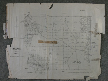
Plan, Ballark: County of Grant, 05/01/1889
... moreep...Barker Library (top floor) Mount Helen goldfields moreep mount wallace ballark A geological plan of Ballark in the County of Grant. ...A geological plan of Ballark in the County of Grant.moreep, mount wallace, ballark -
 Ballan Shire Historical Society
Map - Map. Ballark, Department of Lands and Survey, Ballark. County of Grant, 31/08/1915
... ...moreep...Also those researching families in the area at that time. bungal borhoneyghurk bungeeltap ballark beremboke moreep meredith morrisons moorarbool river Various numbers and directional arrows added to map. ...A map of the Ballark area within the County of Grant showing roads, waterways, property boundaries and property owners in 1915.Significant to people researching land usage and ownership. Also those researching families in the area at that time.A map of Ballark in the County of Grant. Black printing on buff coloured paper. Extra notations by hand and various coloured highlighting of certain features. Details roads, rivers, property boundaries and names of property owners and districts. The map is easily readable although there is some physical damage to the borders and some sellotape residue. Shows a scale in Chains and the number L.6030Various numbers and directional arrows added to map.bungal, borhoneyghurk, bungeeltap, ballark, beremboke, moreep, meredith, morrisons, moorarbool river -
 Federation University Historical Collection
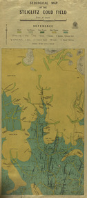
Map, Geological Map of The Stieglitz Gold Field, 1940
... ...moreep...Published 1940." steiglitz geology geological map north albion moreep mining mine caribald reef durdidwarrah gilbraltar hill mount pleasant gully township of steiglitz W.H. ...At the bottom of the 2nd page, there is text that reads "Geologically and topographically surveyed in 1909 by W.H. Ferguson, Assistant Field Geologist. Published 1940."Rectangular geological map edged in masking tape showing Steiglitz, Victoria. Scale 48 chains to 4 inches.steiglitz, geology, geological map, north albion, moreep, mining, mine, caribald reef, durdidwarrah, gilbraltar hill, mount pleasant gully, township of steiglitz, w.h. ferguson, garibaldi reef, yankee gully, kinglock mine engine shaft, herbert werner frederick de nully, albion gully, virago reef, mulrooney's reef