Showing 146 items matching "mound"
-
 Port Fairy Historical Society Museum and Archives
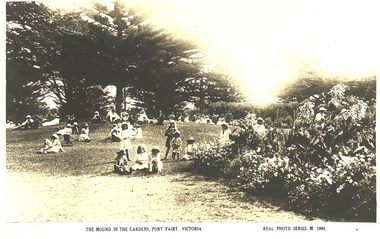
Postcard, Valentines -Real photo Series, "The Mound" Gardens, Port Fairy Victoria
... "The Mound" Gardens, Port Fairy Victoria...mound..."The Mound" Gardens, Port Fairy. Showing children. ...Black and white photograph of Several groups of adults and children sitting on the mound in the gardens..."The Mound" Gardens, Port Fairy Victoria Real photo Series M 1994 back; Valentines postcard...Port Fairy Historical Society Museum and Archives 30 Gipps Street Port Fairy great-ocean-road "The Mound" Gardens, Port Fairy. Showing children. ..."The Mound" Gardens, Port Fairy. Showing children. The Port Fairy Botanical Gardens were formed in 1856 making it one of the earliest gardens in Victoria. The first curator was James Prior, he was paid fifty-two pounds per annum. He was an outstanding curator having been apprenticed to the trade in England at the age of 12, his brother Edward in later years was the Curator of the Koroit Gardens. Prior retired in 1903. During the years of his curatorship Port Fairy was said to have the best gardens outside the city of Melbourne, he was constantly in touch with Baron Von Mueller and later Guilfoyle of the Royal Botanical Gardens of Melbourne. In the early years plants from all over the world were planted here with varying rates of success many of them sent by Baron Von Mueller. In the 1930’ and 40’s the gardens were still very beautiful, and the curator was Roy Manuell. The beautiful iron gates at the entrance were destroyed in the 1946 floods and were replaced in 1989 using some of the material from the original gates. From the 1950’s on the gardens went into a state of decline, much being taken up by the caravan park until in 1986, after a public meeting ‘Friends of the Gardens’ was founded when the entrance section was restored. Black and white photograph of Several groups of adults and children sitting on the mound in the gardens"The Mound" Gardens, Port Fairy Victoria Real photo Series M 1994 back; Valentines postcardmound, gardens, botanical, children -
 Port Fairy Historical Society Museum and Archives
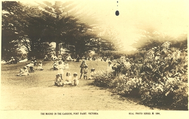
Postcard, kodak Austral, Botanical Gardens Port Fairy Mound area
... Botanical Gardens Port Fairy Mound area...Botanical Gardens Port Fairy Mound area 1900? The Port Fairy Botanical Gardens were formed in 1856 making it one of the earliest gardens in Victoria. ...The Mound in the Gardens Port Fairy Victoria- Real Photo Series M.1994...Port Fairy Historical Society Museum and Archives 30 Gipps Street Port Fairy great-ocean-road Botanical Gardens Port Fairy Mound area 1900? The Port Fairy Botanical Gardens were formed in 1856 making it one of the earliest gardens in Victoria. ...Botanical Gardens Port Fairy Mound area 1900? The Port Fairy Botanical Gardens were formed in 1856 making it one of the earliest gardens in Victoria. The first curator was James Prior, he was paid fifty-two pounds per annum. He was an outstanding curator having been apprenticed to the trade in England at the age of 12, his brother Edward in later years was the Curator of the Koroit Gardens. Prior retired in 1903. During the years of his curatorship Port Fairy was said to have the best gardens outside the city of Melbourne, he was constantly in touch with Baron Von Mueller and later Guilfoyle of the Royal Botanical Gardens of Melbourne. In the early years plants from all over the world were planted here with varying rates of success many of them sent by Baron Von Mueller. In the 1930’ and 40’s the gardens were still very beautiful, and the curator was Roy Manuell. The beautiful iron gates at the entrance were destroyed in the 1946 floods and were replaced in 1989 using some of the material from the original gates. From the 1950’s on the gardens went into a state of decline, much being taken up by the caravan park until in 1986, after a public meeting ‘Friends of the Gardens’ was founded when the entrance section was restored. Sepia photographThe Mound in the Gardens Port Fairy Victoria- Real Photo Series M.1994botanical, garden -
 Federation University Historical Collection
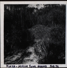
Photograph, Mallee Fowl Mounds, Little Desert
... A visit in 1972 to the Little Desert National Park by a group from Murtoa headed by ranger K Hateley to observe mallee fowls' mounds....Black and white photograph of a mallee fowl mound at Kiata.....1 Front ; Kiata - Mallee Fowl mound Feb. 72 Verso: Little Desert .2 Front: Mallee Fowl incubator mound - Little Desert verso: Little Desert 1972 .3 Practise Mound Mallee Fowl 72 Verso: Little Desert Feb 1972 .4 Verso: Visited Mallee Hen Nest: Jack Watson, Herbert Smith, Lance Yung, H Hately - Ranger Kiata .5 Rev. ...Barker Library (top floor) Mount Helen goldfields A visit in 1972 to the Little Desert National Park by a group from Murtoa headed by ranger K Hateley to observe mallee fowls' mounds. Mallee Fowls Mallee fowls mounds mallee fowl incubator mounds K Hateley John R Watson Lance Yung Herbert Smith Bert Smith Jack Watson .1 Front ; Kiata - Mallee Fowl mound Feb. 72 Verso: Little Desert .2 Front: Mallee Fowl incubator mound - Little Desert verso: Little Desert 1972 .3 Practise Mound Mallee Fowl 72 Verso: Little Desert Feb 1972 .4 Verso: Visited Mallee Hen Nest: Jack Watson, Herbert Smith, Lance Yung, H Hately - Ranger Kiata .5 Rev. ...A visit in 1972 to the Little Desert National Park by a group from Murtoa headed by ranger K Hateley to observe mallee fowls' mounds.Black and white photograph of a mallee fowl mound at Kiata..1 Front ; Kiata - Mallee Fowl mound Feb. 72 Verso: Little Desert .2 Front: Mallee Fowl incubator mound - Little Desert verso: Little Desert 1972 .3 Practise Mound Mallee Fowl 72 Verso: Little Desert Feb 1972 .4 Verso: Visited Mallee Hen Nest: Jack Watson, Herbert Smith, Lance Yung, H Hately - Ranger Kiata .5 Rev. H Smith K Hatelley Kiata L.D. Verso:Mallee Fowl Mounds Little Desert Feb 1972 Agfa -4.2.72 .6 Dad Lance Bert Smith K Hateley Verso: John R Watson Lance Yung (brother -in-law of John (Jack)) Bert Smith, (uncle of Lance ) Feb1972 Little Desertmallee fowls, mallee fowls mounds, mallee fowl incubator mounds, k hateley, john r watson, lance yung, herbert smith, bert smith, jack watson -
 Ringwood and District Historical Society
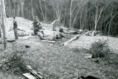
Photograph, Ringwood Rifle Range 500 yard mound. Shooting against Christmas Hills, Unknown date
... Ringwood Rifle Range 500 yard mound. Shooting against Christmas Hills....Ringwood and District Historical Society 125A Warrandyte Road Ringwood North melbourne Digital photograph Ringwood Rifle Range 500 yard mound. Shooting against Christmas Hills. Photograph ...Digital photograph -
 Ringwood and District Historical Society
Photograph, Ringwood Rifle Range 500 yard mound. Shooting against Christmas Hills. W Gough on left, Unknown date
... Ringwood Rifle Range 500 yard mound. Shooting against Christmas Hills. ...Ringwood and District Historical Society 125A Warrandyte Road Ringwood North melbourne Digital photograph Ringwood Rifle Range 500 yard mound. Shooting against Christmas Hills. W Gough on left. ...Digital photograph -
 Ringwood and District Historical Society
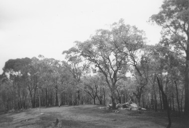
Photograph, Ringwood Rifle Range, Jumping Creek Reserve. Remains of the hut at 600 yards mound after the bushfires, 1962
... Remains of the hut at 600 yards mound after the bushfires, 1962....Remains of the hut at 600 yards mound after the bushfires, 1962. Photograph ...Black and white photograph -
 Art Gallery of Swan Hill
Print, CUMMINGS, Elizabeth, Flinders Mound, 2010
... Flinders Mound...Art Gallery of Swan Hill 133 Monash Drive Swan Hill the-murray Flinders Mound Print CUMMINGS, Elizabeth ... -
Koorie Heritage Trust
Document - Printed Sheets, Brunton, A. A, The Victorian Naturalist Vol. 73, No. 5 September 1956. An Aboriginal Burial Mound, 1956
... An Aboriginal Burial Mound....Koorie Heritage Trust Levels 1 & 3, Yarra Building Federation Square, Melbourne melbourne Burial Mounds - ?boriginal Australians. Sunbury - Burial Mound. ...The article is a most interesting account of a burial so close to Melbourne. The letter to the editor refutes this account but the reader will probably draw their own conclusions.pp. 67-69 & letter to the editor.The article is a most interesting account of a burial so close to Melbourne. The letter to the editor refutes this account but the reader will probably draw their own conclusions.burial mounds - ?boriginal, australians., sunbury - burial mound. -
 Ballarat Heritage Services
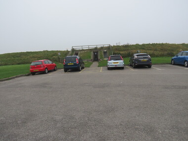
Photograph - Colour, Public toilets hidden in earth mound, Old Sarum, England, English Heritage Site, 2016, 01 November 2016
... Public toilets hidden in earth mound, Old Sarum, England, English Heritage Site, 2016...The nearer end of Mudge's line is marked by an inscribed stone beside the modern A345 at Old Sarum. ordnance survey, william mudge, jesse ramsden, william the conqueror, old sarum, saxon, 1086, england Public toilets hidden in earth mound, Old Sarum, England, English Heritage Site, 2016 Photograph - Colour ...William the Conqueror inherited Old Sarum from the last Saxon king of England. It was an ideal site for a royal castle. It was here in 1070 that William paid off his army after a long and bitter campaign in northern England. It was here in 1086 that he called together all the major landholders in England so they could swear allegiance to him. It was a crucial moment. The Domesday Book was being written, a threatened Viking invasion had only just been averted and William's eldest son was in armed rebellion. Old Sarum was an important place where this Norman king of England held power. In 1794 the Ordnance Survey set out to check the accuracy of the first mapping of Southern England, which had begun ten years earlier. From a point just below Old Sarum Lieutenant William Mudge laid out a base-line 36,574 feet (11,253 metres) long. From each end of the line the positions of distant places were plotted using a huge theodolite made in 1791 by Jesse Ramsden. The accuracy of the process, which was repeated all over England, depended on Jesse Ramsden's craftsmanship and on William Mudge's surveying skill in setting out this first base-line from Old Sarum. The nearer end of Mudge's line is marked by an inscribed stone beside the modern A345 at Old Sarum. ordnance survey, william mudge, jesse ramsden, william the conqueror, old sarum, saxon, 1086, england -
 Ballarat Heritage Services
Photograph - Colour, Entrance to Public toilets hidden in earth mound, Old Sarum, England, English Heritage Site, 2016, 01 November 2016
... Entrance to Public toilets hidden in earth mound, Old Sarum, England, English Heritage Site, 2016...The nearer end of Mudge's line is marked by an inscribed stone beside the modern A345 at Old Sarum. ordnance survey, william mudge, jesse ramsden, william the conqueror, old sarum, saxon, 1086, england Entrance to Public toilets hidden in earth mound, Old Sarum, England, English Heritage Site, 2016 Photograph - Colour ...William the Conqueror inherited Old Sarum from the last Saxon king of England. It was an ideal site for a royal castle. It was here in 1070 that William paid off his army after a long and bitter campaign in northern England. It was here in 1086 that he called together all the major landholders in England so they could swear allegiance to him. It was a crucial moment. The Domesday Book was being written, a threatened Viking invasion had only just been averted and William's eldest son was in armed rebellion. Old Sarum was an important place where this Norman king of England held power. In 1794 the Ordnance Survey set out to check the accuracy of the first mapping of Southern England, which had begun ten years earlier. From a point just below Old Sarum Lieutenant William Mudge laid out a base-line 36,574 feet (11,253 metres) long. From each end of the line the positions of distant places were plotted using a huge theodolite made in 1791 by Jesse Ramsden. The accuracy of the process, which was repeated all over England, depended on Jesse Ramsden's craftsmanship and on William Mudge's surveying skill in setting out this first base-line from Old Sarum. The nearer end of Mudge's line is marked by an inscribed stone beside the modern A345 at Old Sarum. ordnance survey, william mudge, jesse ramsden, william the conqueror, old sarum, saxon, 1086, england -
 Ballarat Heritage Services
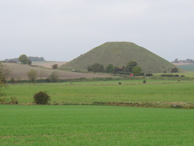
Photograph - Colour, Avebury World Heritage Site, Prehistoric Monuments, England, 2016
... ...mound...Colour photograph of the Silbury Hill, an immense Neolithic man-made mound part of the Avebury World Heritage Site. ...Ballarat Heritage Services PO Box 2209 Bakery Hill Post Office goldfields Colour photograph of the Silbury Hill, an immense Neolithic man-made mound part of the Avebury World Heritage Site. ...Colour photograph of the Silbury Hill, an immense Neolithic man-made mound part of the Avebury World Heritage Site. The Avebury World Heritage Site is a complex of outstanding prehistoric monuments comprising Windmill Hill (Early Neolithic enclosure and Bronze Age burial mounds); Silbury Hill; West Kennet Long Barrow; Avebury Stone Circles and West Kennet Avenue; The Sanctuary (site of stone and timber circles). It is part of National Trust and English Heritage. Visitors may walk to sites.avebury world heritage site, mound, prehistoric monuments, silbury hill, west kennet long barrow, neolithic, world heritage -
 Ringwood and District Historical Society
Photograph, Ringwood Rifle Club 1959. 300 yard mounds
... Written on back of photograph- "Ringwood Rifle Club 1959. 300 yard mounds"....Ringwood and District Historical Society 125A Warrandyte Road Ringwood North melbourne Written on back of photograph- "Ringwood Rifle Club 1959. 300 yard mounds". Black and white photograph Ringwood Rifle Club 1959. 300 yard mounds Photograph ...Black and white photographWritten on back of photograph- "Ringwood Rifle Club 1959. 300 yard mounds". -
 Rutherglen Historical Society
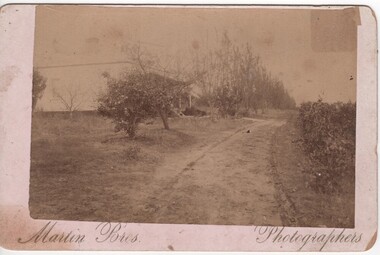
Photograph, Martin Bros, 1900 (Approximate)
... Black & white postcard size sepia photograph, mounded on cardboard, of house and vineyard...Reeve / Orwell Vineyard / Rutherglen Victoria" Black & white postcard size sepia photograph, mounded on cardboard, of house and vineyard Photograph Martin Bros. ...Residence & vineyard bounded by Murray Valley Highway, Hunter Street & Carlyle. Planted by Thos. Reeve, an early settler of Rutherglen. Relatives still living (1985) Mrs Joan Ray, Rutherglen is a grand-daughterBlack & white postcard size sepia photograph, mounded on cardboard, of house and vineyardIn ink on back of photo: "Entrance to Vineyard / & Residence of T. Reeve / Orwell Vineyard / Rutherglen Victoria"orwell vineyard, thomas reeve -
 Stawell Historical Society Inc
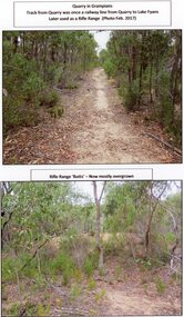
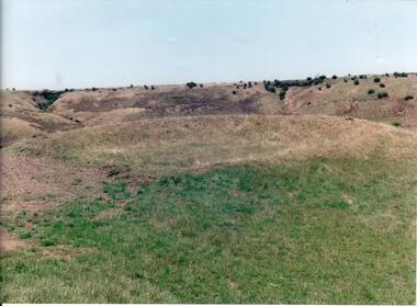
Photograph, A Track into Grampians Quarry -- Previously a Railway Line & Rifle Range Taken 2017 -- 2 Photos -- Coloured
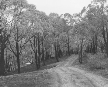
... Two colour photographs of bush setting with track and dirt mound (rifle butts)...Stawell Two colour photographs of bush setting with track and dirt mound (rifle butts) A Track into Grampians Quarry -- Previously a Railway Line & Rifle Range Taken 2017 -- 2 Photos -- Coloured Photograph ...Two colour photographs of Track into Quarry Road Grampians. Once Rail Line used in construction of dam wall, later used as rifle range. The rifle range was once the last part of the railway track that ran to the quarry which was used to cart stone to Lake Fyans when it was being constructed. (1912-1918). The rifle butts are near to or part of the quarry. The Rifle range can still be seen. Two colour photographs of bush setting with track and dirt mound (rifle butts)stawell -
 Ringwood and District Historical Society
Photograph, Ringwood Rifle Range, Jumping Creek Reserve after the bushfires, 1962
... Image shows view looking down range from 600 yard mound - 1962....Ringwood and District Historical Society 125A Warrandyte Road Ringwood North melbourne Image shows view looking down range from 600 yard mound - 1962. Black and white photograph Ringwood Rifle Range, Jumping Creek Reserve after the bushfires, 1962. ...Black and white photographImage shows view looking down range from 600 yard mound - 1962. -
 Bendigo Historical Society Inc.
Slide - BENDIGO VIEWS, Aug 1964
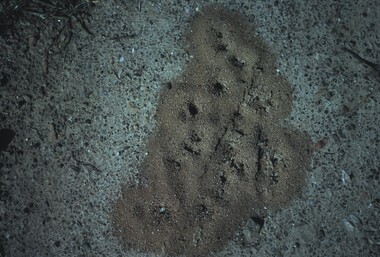
... View of an ants nest with mounds built up around the holes....View of an ants nest with mounds built up around the holes. Slide BENDIGO VIEWS ...Slide. Bendigo Views. View of an ants nest with mounds built up around the holes.slide, bendigo, bendigo views, bendigo views -
 Rutherglen Historical Society
Image, May 1955
... Black and white photograph of the veranda of a house with mounds of dry weeds banked up against it....Rutherglen Historical Society Murray Street Rutherglen high-country Tumble grass or umbrella grass surrounding house at Brimin 1955 buildings carinya umbrella grass tumble grass brimin On back of photo: "Umbrella grass banked up around 'Carinya' May 1955" Black and white photograph of the veranda of a house with mounds of dry weeds banked up against it. Image ...Tumble grass or umbrella grass surrounding house at Brimin 1955Black and white photograph of the veranda of a house with mounds of dry weeds banked up against it.On back of photo: "Umbrella grass banked up around 'Carinya' May 1955"buildings, carinya, umbrella grass, tumble grass, brimin -
 Hume City Civic Collection
Photograph, early 1990's
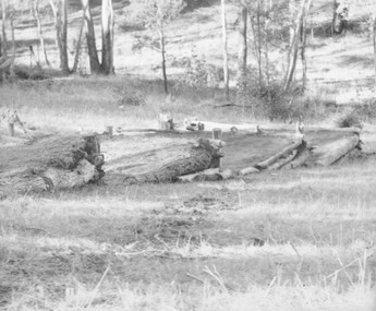
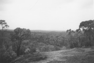
... It is situated on a cleared mound with small hills across the skyline....It is situated on a cleared mound with small hills across the skyline. ...The set of 20 photographs were taken of a number of archaeological sites in Sunbury of sacred sites and aboriginal rings. The photographs were included in a study of these sites which was published by the Shire of Bulla in the early 1990's.Site of an Aboriginal Ring near Sunbury. It is situated on a cleared mound with small hills across the skyline.aboriginal ring sites, george evans collection -
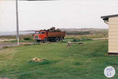 Port Fairy Historical Society Museum and Archives
Photograph
... Coloured photograph of Tip truck with load of bluestone in foreground whale bone on a mound in front of house...Port Fairy Historical Society Museum and Archives 30 Gipps Street Port Fairy great-ocean-road South Beach Development ocean drive truck bluestone whale bone south beach development 407/23 (Label has now been removed (2021) Coloured photograph of Tip truck with load of bluestone in foreground whale bone on a mound in front of house Photograph Photograph ...South Beach Development Coloured photograph of Tip truck with load of bluestone in foreground whale bone on a mound in front of house407/23 (Label has now been removed (2021)ocean drive, truck, bluestone, whale bone, south beach, development -
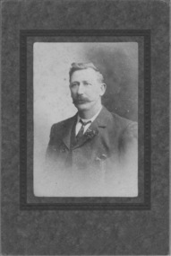 Emerald Museum & Nobelius Heritage Park
Photograph, Nightingale/Thompson Collection, circa 1870 - 1920
... Studio portrait, sepia photograph mounded on brown card; man age (40-50) dressed in suit and tie...Emerald Museum & Nobelius Heritage Park 5 Crichton Rd Emerald yarra-valley-and-the-dandenong-ranges Thompson collection Thompson Collection Nightingale None, but manufacturer's details on card; Melba, Melbourne Studio portrait, sepia photograph mounded on brown card; man age (40-50) dressed in suit and tie Nightingale/Thompson Collection Photograph Melba ...Thompson collectionStudio portrait, sepia photograph mounded on brown card; man age (40-50) dressed in suit and tieNone, but manufacturer's details on card; Melba, Melbournethompson collection, nightingale -
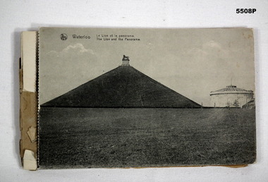 Bendigo Military Museum
Postcard - POSTCARD BOOKLET, PHOTOGRAPHIC, 1910-1919
... The images of the Battle scene are; the Lion Mound, Waterloo, The Three Monuments, French Monument, Farm La Haye Sainte, The Prussian Monument, Hougament farm, The Lion, Farm Papelottre, The Belle Alliance Building....This is where all the dead soldiers were buried, so they built this big mound it. It is a good walk to get to the top. - This is where all the battle was, around these ....... ...This is where all the dead soldiers were buried, so they built this big mound it. It is a good walk to get to the top. - This is where all the battle was, around these ....... ...The images of the Battle scene are; the Lion Mound, Waterloo, The Three Monuments, French Monument, Farm La Haye Sainte, The Prussian Monument, Hougament farm, The Lion, Farm Papelottre, The Belle Alliance Building.This is a bound booklet of Black and White images of the Battle of Waterloo area. On the photos is the caption in French and English. The front cover is missing. Some of the postcards are detached on the "dotted edge". The first two cards have a letter written in pencil from soldier J. Burns to his mum.On the back of photo 1 & 2 is written the letter from J. Burns to his Mum. Dated Bouffioul - Belgium. 3-3-19. Dear Mum, These are a few views of Waterloo, we went right up to the top of this place. This is where all the dead soldiers were buried, so they built this big mound it. It is a good walk to get to the top. - This is where all the battle was, around these ....... Well Mum I am ok again, this is a little souvenir. I can say I have been on the Fields of Waterloo. Well Mum I received another parcel from........? today and it was good too. I will write a letter later so Good Bye Dear Mum for the present, from your loving son James. On the rear post card, written in pencil is: - No.60893 Pte J Burns, 5th Battalion A.I.F. France.postcards, battle of waterloo -
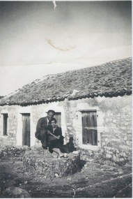 Ithacan Historical Society
Photograph, Stone cottage, Ithaca, C1930S
... A black and white photograph of a lady and man photographed on a mound of rocks outside a stone cottage which has a tiled roof....A black and white photograph of a lady and man photographed on a mound of rocks outside a stone cottage which has a tiled roof. ...The young couple standing outside the stone cottage in Kioni, Ithaca are Yianni Rafopoulos (Bourlotos) and Diamando (Manto) Raftopoulos nee Paizis. The house is typical of the traditional stone cottages built on Ithaca in times past. Although similar cottage are still standing, some of them lovingly restored, there are also many deserted and in disrepair or ruin as a result of migration over generations and inheritance issues. A black and white photograph of a lady and man photographed on a mound of rocks outside a stone cottage which has a tiled roof. -
Glenelg Shire Council Cultural Collection
Photograph - Photograph - Land Reclamation, n.d
... Ship in background left, mound of filling and earth moving equipment centre/right background....Ship in background left, mound of filling and earth moving equipment centre/right background. ...Port of Portland Authority ArchivesBack: B in blue biroport of portland archives, portland harbour -
Glenelg Shire Council Cultural Collection
Photograph - Photograph - Land Reclamation, n.d
... Ship in background left, mound of filling and earth moving equipment centre/right background....Ship in background left, mound of filling and earth moving equipment centre/right background. ...Port of Portland Authority ArchivesBack: B in blue biroport of portland archives, land reclamation -
 Rutherglen Historical Society
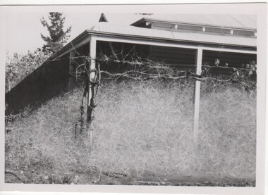
Image, May 1955
... Black and white photograph of the veranda of a house, with trellised grape vines across the front, and windblown weeds drifted in a mound against the veranda....Rutherglen Historical Society Murray Street Rutherglen high-country Tumble grass or umbrella grass surrounding house at Brimin 1955 carinya buildings umbrella grass tumble grass brimin On back of photo: "Umbrella grass banked up around 'Carinya' May 1955" Black and white photograph of the veranda of a house, with trellised grape vines across the front, and windblown weeds drifted in a mound against the veranda. Image ...Tumble grass or umbrella grass surrounding house at Brimin 1955Black and white photograph of the veranda of a house, with trellised grape vines across the front, and windblown weeds drifted in a mound against the veranda.On back of photo: "Umbrella grass banked up around 'Carinya' May 1955"carinya, buildings, umbrella grass, tumble grass, brimin -
 Darebin Parklands Association
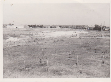
Former tip site area 1979, Darebin Parklands Association, 1979
... Annotated on back with [May 1979. Planting near mound adjacent to Separation st. Yarana rd. former tip site area}]....Alphington melbourne Annotated on back with [May 1979. Planting near mound adjacent to Separation st. Yarana rd. former tip site area}]. ...B&W photograph. This item and all other Darebin Parklands Association archival material is now held by State Library Victoria (Accession No: YMS 13746). Please contact State Library Victoria if access is required.Annotated on back with [May 1979. Planting near mound adjacent to Separation st. Yarana rd. former tip site area}]. -
 Flagstaff Hill Maritime Museum and Village
Clothing - Nightgown
... Nightgown, women's long white nightie with longs sleeves, mounded collar front opening with pin tucked yoke. ...Flagstaff Hill Maritime Museum and Village 89 Merri Street Warrnambool great-ocean-road Flagstaff Hill Warrnambool Shipwrecked-coast Flagstaff-Hill Flagstaff-Hill-Maritime-Museum Maritime-Museum Shipwreck-coast Flagstaff-Hill-Maritime-Village nightgown nightdress nightie night dress nightwear sleepwear clothing fashion 19th century handmade clothing Nightgown, women's long white nightie with longs sleeves, mounded collar front opening with pin tucked yoke. ...Nightgown, women's long white nightie with longs sleeves, mounded collar front opening with pin tucked yoke. Gown is trimmed with lace. flagstaff hill, warrnambool, shipwrecked-coast, flagstaff-hill, flagstaff-hill-maritime-museum, maritime-museum, shipwreck-coast, flagstaff-hill-maritime-village, nightgown, nightdress, nightie, night dress, nightwear, sleepwear, clothing, fashion, 19th century, handmade clothing -
 Hopetoun & District Historical Society
Photograph, Mouse plague, Woomelang c 1917, 1917 Woomelang, Greg Dwyer Photographer
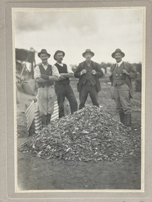
... Four men standing behind a metre tall mound of dead mice in the 1917 mouse plague J. ...Hopetoun & District Historical Society 88 Evelyn Sreet Hopetoun grampians Mice plague Mallee Woomelang Vermin Inspector 1917 Four men standing behind a metre tall mound of dead mice in the 1917 mouse plague J. ...Four men standing behind a metre tall mound of dead mice in the 1917 mouse plague J. Tolmie R is the Vermin Inspectormice plague, mallee, woomelang, vermin inspector, 1917 -
 Ringwood and District Historical Society
Photograph, Ringwood Rifle Range after the bushfires of January 1962
... Scene looking towards the hut at 300 yard mound."...Scene looking towards the hut at 300 yard mound." Black and white photograph Ringwood Rifle Range after the bushfires of January 1962 Photograph ...Black and white photographWritten on back of photograph- "Ringwood Rifle Range after the bushfires of January 1962. Scene looking towards the hut at 300 yard mound." -
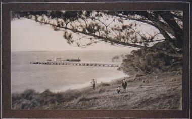 Phillip Island and District Historical Society Inc.
Photograph, Cowes Pier, Phillip Island, 1914
... Three figures amongst mounds of grass and overhanging Pine tree branch. ...Three figures amongst mounds of grass and overhanging Pine tree branch. ...The Jetty first built in 1870 connected Cowes to Crib Point. The service for mail, provisions and visitors from the mainland. A bridge to the Island was built in 1942 from San Remo.View of Jetty from Mussell Rocks, in the foreground a grassy slope. Three figures amongst mounds of grass and overhanging Pine tree branch. A very picturesque view.local history, photographs, jetties, cowes, phillip island, black & white photograph, betty kus collection, jetty cowes, cowes pier, bruce bennett