Showing 3 items matching "mount pleasant gully"
-
 Federation University Historical Collection
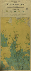
Map, Geological Map of The Stieglitz Gold Field, 1940
... ...mount pleasant gully...Published 1940." steiglitz geology geological map north albion moreep mining mine caribald reef durdidwarrah gilbraltar hill mount pleasant gully township of steiglitz W.H. Ferguson Garibaldi Reef Yankee Gully Kinglock Mine Engine Shaft herbert werner frederick de nully Albion Gully Virago Reef Mulrooney's Reef Rectangular geological map edged in masking tape showing Steiglitz, Victoria. ...At the bottom of the 2nd page, there is text that reads "Geologically and topographically surveyed in 1909 by W.H. Ferguson, Assistant Field Geologist. Published 1940."Rectangular geological map edged in masking tape showing Steiglitz, Victoria. Scale 48 chains to 4 inches.steiglitz, geology, geological map, north albion, moreep, mining, mine, caribald reef, durdidwarrah, gilbraltar hill, mount pleasant gully, township of steiglitz, w.h. ferguson, garibaldi reef, yankee gully, kinglock mine engine shaft, herbert werner frederick de nully, albion gully, virago reef, mulrooney's reef -
 Eltham District Historical Society Inc
Album - Photograph Album, J.A. McDonald, Bridge and Road Reconstruction Works, Shire of Eltham, 1952-1962
... Gully...Lower Plenty Bridge...Lower Plenty Footbridge...Lower Plenty Oval...Lower Plenty Road...Lower Plenty...Main Road...Methodist Church...Montmorency...Mount Pleasant...Jolly Kangaroo Ground Kangaroo Ground-Queenstown Road Kangaroo Ground-St Andrews Road Lilydale Shire Office Long Gully Bridge Long Gully Creek Long Gully Road Long Gully Lower Plenty Bridge Lower Plenty Footbridge Lower Plenty Oval Lower Plenty Road Lower Plenty Main Road Methodist Church Montmorency Mount Pleasant Road New Holland Old Healesville Road Opening Ceremony Oxley Bridge Para Road Paul Creek Bridge Paul Creek Road Paul Krafeznk Pinnacle Lane Plaques Plenty River Trail Plenty River Presbyterian Church Prof Donald Thomson Pryor Street railway crossing Railway Parade Rattray Road Reconstruction works Reichelt Avenue Research (Vic.) ...J.A. McDonald produced this record in the course of his responsibilities as Shire Engineer for Eltham Shire Council.Record of various Shire of Eltham infrastructure works undertaken during the period of 1952-1962 involving bridge and road reconstruction projects, sometimes with Eltham Shire Council Project Reference numbers quoted. It was during this period that a number of significant improvements were made to roads and new bridges constructed within the shire that remain in place as of present day (2022). In many situations, the photos provide a tangible visible record of infrastructure that existed throughout the early days of the Shire. The album was put together by or under the direction of the Shire Engineer, J.A. McDonald.a. gillies, alistair knox park, benchmark studies, bend of islands, blease road, box hill state school, box hill teachers college, box hill tip, bridge construction, bridge street bridge, bridge, brisbane street, brougham steet, bulldozer, cecil street, charis pelling, cherry tree road, city of preston, cr. a. brinkkotter, cr. charis pelling, cranes, cromwell street, diamond creek (creek), diamond street, dixons creek bridge, dixon's creek road, drott, eltham leisure centre, eltham north, eltham police station, eltham, eltham-yarra glen road, f. wood, fitzsimons lane bridge, flat rock road, flood damage, floods, floodwater, footpaths and gutters, ford service garage, g. blair, garden hill, glen park bridge, glenauburn road, grand hotel, haldane road, healesville, healesville-yarra glen road, heidelberg-kinglake road, henley road bridge, henley road, hill property, hurstbridge water scheme, hurstbridge, hurstbridge-arthurs creek road, infrastructure, j. jolly, kangaroo ground, kangaroo ground-queenstown road, kangaroo ground-st andrews road, lilydale shire office, long gully bridge, long gully creek, long gully road, long gully, lower plenty bridge, lower plenty footbridge, lower plenty oval, lower plenty road, lower plenty, main road, methodist church, montmorency, mount pleasant road, new holland, old healesville road, opening ceremony, oxley bridge, para road, paul creek bridge, paul creek road, paul krafeznk, pinnacle lane, plaques, plenty river trail, plenty river, presbyterian church, prof donald thomson, pryor street, railway crossing, railway parade, rattray road, reconstruction works, reichelt avenue, research (vic.), research oval, road construction, rymers corner, shire of eltham, shire of whittlesea, silvan road bridge, silver street bridge, silver street, sir dallas brooks, smedley property, st andrews, steels creek, susan street, tarrawarra, tony carberry, uniting church, upper yarra dam, upper yarra reservoir, w.e. wolf, waterfall property, watsons creek, wattletree road bridge, wattletree road, wattletree road bridge, worlingworth, yarra glen, york street, yow yow creek -
 Federation University Historical Collection
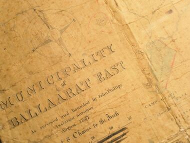
Map, Municipality of Ballarat East, 1857
... mount pleasant...golden point...white flat...nightingale...malekoff...old post office hill...red streak...gumtree flat...old gravelpits...bakery hill...ballaarat flat...the camp...specimen gully...The map has read and blue highlights, and identifies areas such as Mount Pleasant, Golden Point, White Flat, Nightingale, Malekoff, Old Post Office Hill, Red streak, Gumtree Flat, Old Gravelpits, Bakery Hill, Ballaarat Flat, The Camp, Specimen Gully, Pennyweight Hill, Warrenheip Gully, Gays Gully, Pennyweight Flat, Eureka, Black Hill, Pinchgut, Crocodile, Hit or Miss, Little Bendigo, Brown Hill, Mopoke, Cricket Reserve, Canadian Hotel, Ballarat East...In 2007 this map was listed on the inaugural Ballarat Treasure's Register. mount pleasant golden point white flat nightingale malekoff old post office hill red streak gumtree flat old gravelpits bakery hill ballaarat flat the camp specimen gully pennyweight hill warrenheip gully gays gully pennyweight flat eureka black hill pinchgut crocodile hit or miss little bendigo brown hill mopoke cricket reserve canadian hotel ballarat eastm phillips john phillips field draughtsman ballarat east ballarat east map Large map backed onto linen. ...Gold was discovered in Ballarat in 1851. This plan was created six years later and names some of the great gold locations of Ballarat East. It also shows the locality of the Eureka Stockade (1854) and the walking tracks and roads on the Ballarat East Goldfield.In 2007 this map was listed on the inaugural Ballarat Treasure's Register.Large map backed onto linen. The map has read and blue highlights, and identifies areas such as Mount Pleasant, Golden Point, White Flat, Nightingale, Malekoff, Old Post Office Hill, Red streak, Gumtree Flat, Old Gravelpits, Bakery Hill, Ballaarat Flat, The Camp, Specimen Gully, Pennyweight Hill, Warrenheip Gully, Gays Gully, Pennyweight Flat, Eureka, Black Hill, Pinchgut, Crocodile, Hit or Miss, Little Bendigo, Brown Hill, Mopoke, Cricket Reserve, Canadian Hotel, Ballarat Eastmount pleasant, golden point, white flat, nightingale, malekoff, old post office hill, red streak, gumtree flat, old gravelpits, bakery hill, ballaarat flat, the camp, specimen gully, pennyweight hill, warrenheip gully, gays gully, pennyweight flat, eureka, black hill, pinchgut, crocodile, hit or miss, little bendigo, brown hill, mopoke, cricket reserve, canadian hotel, ballarat eastm phillips, john phillips, field draughtsman, ballarat east, ballarat east map