Showing 75 items matching "mt dandenong north"
-
 Mt Dandenong & District Historical Society Inc.
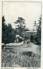
Photograph, Mt Dandenong North. Showing "Mountjoy"
... Mt Dandenong North. Showing "Mountjoy"....mt dandenong north.... Mt. Dandenong North was renamed Kalorama in 1926....On front ; Mt. Dandenong North. Showing "Mountjoy.".... Mt. Dandenong North was renamed Kalorama in 1926. postcard ...The building with the white picket fence is the Beulah Tea Gardens opened by Eliza Hand c1904 at The Gap (now FiveWays). The building is still operating as a cafe. The Tourist Road does not yet exist. Old Coach Road comes into the picture from the right and the horse and cart is heading up Ridge Road. The elm trees can be seen on the left. The building up on the hill is the Mountjoy Guest House. ‘Mountjoy’ was built by the Paynter family in 1905. It had fourteen bedrooms, a dining room and sitting room, kitchen with a big wood burning range and verandahs on three sides. There were commanding views of the eastern ranges and the city to the west. Ellis Jeeves purchased ‘Mountjoy’ in 1908 and it soon became a popular tourist destination, the coach yards making it a centre of the district. ‘Mountjoy’ is a central feature of many photographs of Kalorama in the 1900s. The building burned down in 1975. Mt. Dandenong North was renamed Kalorama in 1926.Black and white postcard showing a horse and cart on road between two buildings.On front ; Mt. Dandenong North. Showing "Mountjoy."postcard, mountjoy, guest house, beulah tea room, beulah, mt dandenong north, kalorama -
 Mt Dandenong & District Historical Society Inc.
Photograph, Post Office Mt Dandenong North c1911, c1911
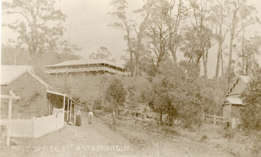
... Post Office Mt Dandenong North c1911...Mt Dandenong North... Mt Dandenong North Post Office Ridge Road Landscape view ...Landscape view. Mountjoy on hill, post office and residence with fence and sign post. Mrs Eliza Hand and (probably) Miss Florence hand outside. Another person standing on Ridge Road on the left. On right, the Methodist Church.eliza hand, florence hand, methodist church, mountjoy, mt dandenong north, post office, ridge road -
 Ringwood and District Historical Society
Framed photograph, William Cook Pioneer of Ringwood and Mt Dandenong North c 1914
... William Cook Pioneer of Ringwood and Mt Dandenong North c... and lived in Mt Dandenong North at one time c.1914.... was a pioneer in Ringwood and lived in Mt Dandenong North at one time c ...Photo of William Cook who was a pioneer in Ringwood and lived in Mt Dandenong North at one time c.1914.Coloured photograph in wooden frame with buff coloured inset +Additional Keywords: Cook, WilliamBack of frame inscribed William Cook, Pioneer. -
 Mt Dandenong & District Historical Society Inc.
Photograph, Post Office and 'Mountjoy', Mt. Dandenong North, 1913
... Post Office and 'Mountjoy', Mt. Dandenong North... and Beulah Tea Rooms/Mt Dandenong North Post Office in centre... with Mountjoy Guest House and Beulah Tea Rooms/Mt Dandenong North Post ...Rose Series post card #182Copy of Rose Series postcard #182 showing Kalorama Gap in 1913. Haystacks in foreground with Mountjoy Guest House and Beulah Tea Rooms/Mt Dandenong North Post Office in centre. This photograph has a detailed inscription on the back handwritten by John Lundy-Clarke in 1974.Kalorama Gap in 1913 The elm trees are in the centre of the picture. One of these is really two as two suckers of the further tree were twisted together by Fred Jeeves in 1898 and grew as one tree. The other was planted in 1880. The shop is the shop of Mrs Eliza Hand and daughter Florence. The closed in far end of the verandah was the Mount Dandenong North Post Office. The large house is “Mountjoy” owned and run by the Jeeves Family from 1908 till 1943. It was built in 1905 by the Paynters who sold to Ellis Jeeves in 1908.He moved his line of coaches from “Kalorama” his old homestead and housed the horses in a line of stables behind “Mountjoy”. Price’s house, which contained their shop, the first one on the mountain, opened 1906, can be seen faintly behind the pine tree opposite the bend in the road, which was the main road then and now is Ridge Road. The Price’s house just shows in two tiny pieces, one on each side of the pine tree half way up. The house to the right of and high up the pine tree is Walker’s cottage which exists today opposite Jack Kidd’s home at the far edge of Lt 2 Village Settlement and was between Main Road and Barbers Road which runs down the left behind the elms. Walker’s homestead can be seen near left edge of picture 2/3 way up. The roof of the Methodist Church shows among trees left of picture. This, like Mrs Hand’s shop was built on portions separated from Isaac Jeeves’ Selection “C” known as Jeeves Saddle. kalorama gap, five ways, mountjoy, john lundy-clarke, beulah tea rooms, post office, fred jeeves, paynter, jeeves, frederick jeeves, price, walker, jack kidd -
 Mt Dandenong & District Historical Society Inc.
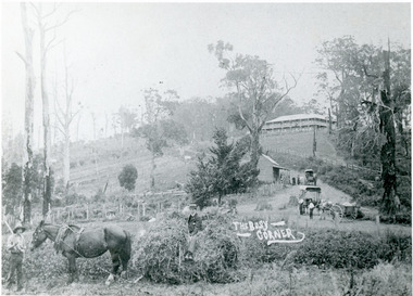
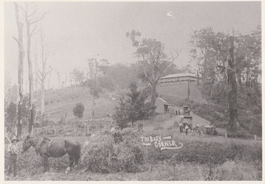
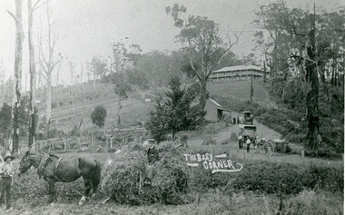
Photograph, 'The Busy Corner' FiveWays c1909, c1909
... Mt Dandenong North... Guest House on crest, Mt Dandenong North Post Office, three... Jeeves Mt Dandenong North Post Office Theo Hand Landscape view ...Landscape view of Ridge and Barbers Roads showing Mountjoy Guest House on crest, Mt Dandenong North Post Office, three delivery carts and people. Lower LH corner Fred Jeeves (standing), Theo Hand (on wagon) and Blossom (horse).mountjoy, ridge road, fiveways, barbers road, frederick jeeves, mt dandenong north, post office, theo hand -
 Mt Dandenong & District Historical Society Inc.
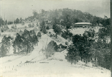
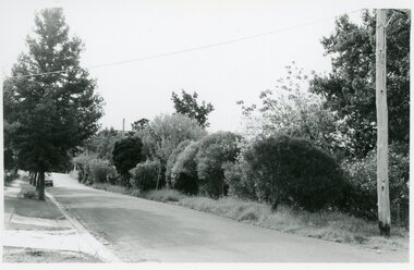
Photograph, The Gap Under Snow 1921, 1921
... Mt Dandenong North... Dandenong North) to pass out of picture left in centre of picture... The Gap Post Office Mt Dandenong North Snow The Gap under snow ...Snow scene looking up through The Gap (FiveWays) with Mountjoy Guest House on the hill to the right. The shop and post office are seen in the centre of the picture. This photograph has a detailed inscription on the back handwritten by John Lundy-Clarke in 1974.The Gap under snow 1921. “Mountjoy” on hill. New CRB road formation (unmetalled) comes into picture lower left corner, passes left of dray under the elms, then circles around behind the trees behind Miss Hands shop and home and Post Office (Mt Dandenong North) to pass out of picture left in centre of picture. It passes between Ted Prices Hay & Corn store and Walker’s house where the Estate Agency was later placed. Main Road then in centre of picture bend right behind Mountjoy. Price’s house and shop behind the blackwood left of road bend. CRB cuts across Barbers left of Elm trees.john lundy-clarke, kalorama, mountjoy, mountjoy, the gap, post office, mt dandenong north, snow -
 Mt Dandenong & District Historical Society Inc.
Photograph, The Busy Corner, 1907
... mt dandenong north... “Beulah Tea Rooms” which soon afterwards became the Mt Dandenong... road beulah tea rooms post office mount dandenong north mt ...View of Jeeves Saddle in 1907 showing everyday life and including important people and businesses from early settlement - Dodd's grocery and meat cutting carts; Beulah tea Rooms/Post Office; Mrs Hand, Fred Jeeves, Theo Hand.This photograph has a detailed inscription on the back handwritten by John Lundy-Clarke in 1974.“Jeeves Saddle” in 1907. Isaac Jeeves special strip of land Crown Allotment “C” 7 chains wide, lay between the sledge load of pea stalks and the far end of the verandah on Mrs Hand’s “Beulah Tea Rooms” which soon afterwards became the Mt Dandenong North Post Office. The coach road came up from the right behind the tall stump. The big woman in black was Mrs Hand. The wagon at the shop was Dodd’s grocery cart. The nearer wagon was the first coach on the mountain which had belonged to Briarty. The small cart was Dodd’s meat cutting cart. The elm trees are in the centre of the picture and above them is Price’s sign advertising their shop and newsagency. The big house is “Mountjoy” burnt 1975. Walker’s house is among the big trees left centre. Boy at horse’s head is Fred Jeeves. Boy on sledge is Theo Hand. The horse is “Blossom”. Barbers Road goes to the left from behind the elm trees.jeeves, theo hand, fred jeeves, isaac jeeves, barbers road, beulah tea rooms, post office, mount dandenong north, mt dandenong north, kalorama, coach, mountjoy -
 Mt Dandenong & District Historical Society Inc.
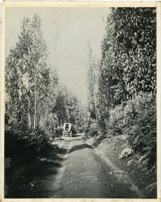
Photograph, Jeeves Coach on CRB Road at Foot of Farringdon Road Kalorama, 1920, 1920
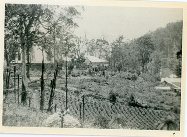
... mt dandenong north... Kalorama (Mt Dandenong North) 1920. Road was formed most... kalorama mt dandenong north mt dandenong tourist road john lundy ...Scene looking down Farringdon Road showing Jeeves horse drawn coach going along the CRB road (Mt Dandenong Tourist Road) in 1920. Detailed inscription on the back handwritten by John Lundy-Clarke in 1974.Jeeves Coach on CRB road at foot of Farringdon Road Kalorama (Mt Dandenong North) 1920. Road was formed most of the length from Montrose by contractors Bladin and Dick employing Robert Logan the younger, in 1919 and lay unmetalled till metalled by the contractors in 1922. Mountain ash trees in foreground were on Thomas Hand’s original 23 acre holding. Those beyond coach were on Isaac Jeeves original 160 acre holding Selection Crown Allotment 925(B). This was the area forming part of the inheritance lost by John William Richardson because of the expense of his wife’s illness. Hand enlarged his 23 acres to 305 in 1874. William and his family grew large crops of raspberries on his area, part of which is in the foreground. It had been cleared by his father’s employees before 1877. The section below the Main Road was cultivated by Fred hand, son of William and grandson of Thomas in the twenties before he moved to Redcliffes where he is today (1974). Comment by John Lundy-Clarke 10.5.1974 coach service, jeeves, crb road, farringdon road, kalorama, mt dandenong north, mt dandenong tourist road, john lundy-clarke, coach -
 Mt Dandenong & District Historical Society Inc.
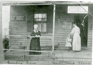
Photograph, Grandma Hand, Gert and Aunt Florrie at Kalorama Post Office c1910, c1910
... Mt Dandenong North...Mt Dandenong & District Historical Society Inc. Farndons ...Kalorama Post Office (Mt Dandenong Nth) at Five Ways c1910. The building is "Beulah Tea Rooms" which had some post office services. Grandma Hand - Eliza Hand nee Erith is in the white bonnet. Gert - Gertrude Badenhop is her grand-daughter with Florrie Hand - later Mrs Walker.eliza hand, florence hand, fiveways, mt dandenong north, post office, tea rooms, gertrude badenhop -
 Mt Dandenong & District Historical Society Inc.
Photograph, The Gap at Kalorama 1913, 1913
... Mt Dandenong North...-and-the-dandenong-ranges FiveWays Mountjoy Post Office Mt Dandenong North ...1913 scene looking up to Mountjoy Guest House at the Kalorama Gap (FiveWays). Post Office and tea rooms with white picket fence. Jeeves Coach on the road. This photograph has a detailed inscription on the back handwritten by John Lundy-Clarke in 1974. The Gap Kalorama 1913. ‘Mountjoy’ guest house. Mount Dandenong North Post Office. Jeeves coach.fiveways, mountjoy, post office, mt dandenong north, the gap, jeeves, coach -
 Mt Dandenong & District Historical Society Inc.
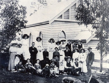
Photograph, Congregation of Kalorama Methodist Church 1911
... Methodist Church at FiveWays. The area was known as Mt Dandenong... Methodist Church at FiveWays. The area was known as Mt Dandenong ...Congregation gathered for photograph at front of Kalorama Methodist Church at FiveWays. The area was known as Mt Dandenong North until 1926 when the name was changed to Kalorama. The people assembled are all members of the local community. The church was built by the community in 1910.Black and white photograph showing a group of 31 people gathered in front of a wooden church building.kalorama, methodist church -
 Mt Dandenong & District Historical Society Inc.
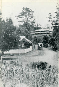
Photograph, View of Kalorama Gap 1905
... Hand’s “Beulah Tearooms” later Mt Dandenong North Post Office... Dandenong North Post Office is above Price’s roof. Black and white ...Kalorama Gap viewed from the South West in 1908. Ellis Jeeves' 'Mountjoy' is in the centre with the stables to the left. The raspberry patch belongs to Harry Walker and the building centre right to Edward Joseph Price. John Lundy-Clarke grew up in the Kalorama/Mt Dandenong area and later in life (1972-74) began to write a comprehensive history of the area working from an original settlement map in an effort to cover all areas.Black and white photograph showing an extensive raspberry crop in the foreground with a house and outbuilding in the centre and another dwelling centre right. Handwritten description on reverse by John Lundy-Clarke. 1908 view of Kalorama Gap taken from corner of Village Settlement LOTS 2 and 3 on Ridge (then Main Road) which crosses centre of picture with Walker’s driveway dropping left. Walker’s raspberry patch in foreground. “Mountjoy” in centre of picture with coaching stables on left. Price’s house and shop on right showing large cross room used by the Village Settlers for dancing. Mrs Hand’s “Beulah Tearooms” later Mt Dandenong North Post Office is above Price’s roof.kalorama gap, kalorama, harry walker, walker, edward joseph price, raspberry, mountjoy -
 Mt Dandenong & District Historical Society Inc.
Photograph, The Busy Corner, 1907
... to become the Mt Dandenong North Post Office. Big woman in black... was Hand's Beulah Tea Rooms soon to become the Mt Dandenong North ...View of Kalorama gap taken in 1907 showing Eliza Hand outside Beulah Tea Rooms, Briartys Coach, Dodd's Grocery cart and Meat Cutting cart. In foreground Fred Jeeves is standing and Theo Hand on hay. Mountjoy is in the background.This photograph has a detailed inscription on the back handwritten by John Lundy-Clarke in 1974.The Kalorama Gap in 1907. The coach road comes from right behind old stump. The shop was Hand's Beulah Tea Rooms soon to become the Mt Dandenong North Post Office. Big woman in black was Mrs Hand. wagon was Dodd's Grocery cart. "Mountjoy" on hilltop. The wagon with man was the first coach on the mount (Briartys). Small cart was Dodd's meat cutting cart. Horse at sledge was "Blossom" boy at her head was Fred Jeeves. Boy on sledge was Theo hand. Elm trees in centre of picture with Prices sign advertising shop and newsagency above them.mountjoy, beulah tea rooms, fred jeeves, theo hand, dodd's grocery cart, cart, coach, briartys -
 Ringwood and District Historical Society
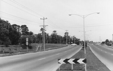
Photograph, Maroondah Highway East, Ringwood- 1971. Looking east towards Mt Dandenong Road
Black and white photographWritten on back of photograph: "Maroondah Highway, looking east towards Mt Dandenong Road turnoff past lake. 1971." -
 Ringwood and District Historical Society
Photograph, Maroondah Highway East, Ringwood- 1965. Corner of Mt Dandenong Road before widening
Black and white photograph (3 separate images)Typed note on back of photograph: "M'dah Hwy, June 1965, before it was widened from Mt Dandenong on." -
 Ringwood and District Historical Society
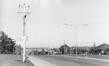
Photograph, Maroondah Highway East, Ringwood- 1969. Looking west towards Ringwood from Mt Dandenong Road intersection
Black and white photographWritten on back of photograph: "Nov 1969, Cnr Mt Dandenong Road and Maroondah Highway." -
 Ringwood and District Historical Society
Photograph, Maroondah Highway East, Ringwood- 1969. Looking west towards Ringwood from Mt Dandenong Road
Black and white photographWritten on back of photograph: "Cnr Maroondah Highway and Mt Dandenong Road. Nov 1969." -
 Ringwood and District Historical Society
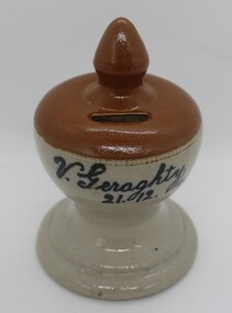
Ceramic - Money Box, Geraghty, Vincent, Pottery, handmade money box from Ringwood. 1914, 21-Dec-14
Made by young Vincent Geraghty from clay from his father's Firebrick, Insulators & Pottery Company situated in East Ringwood. Vincent was one of a family of ten who were early settlers in East Ringwood (corner of Federal and Mt Dandenong Roads)Pottery, handmade money box. Grey base, brown top with coin slot and pointed top. Base includes black printing - F.I.& P. Co. of Ringwood. +Additional Keywords: Geraghty, Vincent / F. I. & P. Co. / Firebrick, Insulators and Pottery Co.V. Geraghty - 21.12.14 -
 Ringwood and District Historical Society
Photograph, Ringwood Fire Station at 255 Maroondah Highway circa 1998, Feb-98
This fire station was closed and a new one opened on Maroondah Highway on the site of the old miner's cottage near the corner of the Highway and Mt Dandenong Road.Five coloured photographs of the Ringwood fire station at 255 Maroondah Highway and of the fireman's house when it was sold. It later became 'The Fire Station Restaurant.' -
 Ringwood and District Historical Society
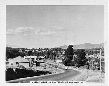
Photograph/Postcard, Souvenir photograph - Murray Views No.1 - Approaching Ringwood, Vic
Black & white "Murray Views" souvenir photograph - View towards Mt. Dandenong from Heatherdale Road along Maroondah Highway, Ringwood. Circa 1950s. -
 Ringwood and District Historical Society
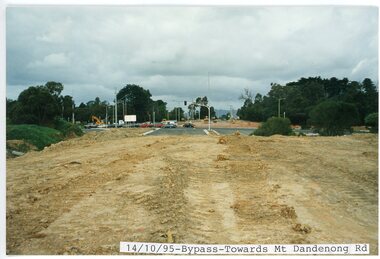
photograph, Eastlink Ringwood Bypass Construction-Bypass-Towards Mt Dandenong Rd 14/10/95
Colour photographWritten on back of photo: "Bypass From Suda Av Looking Towards Mt Dandenong Rd 14/10/95" -
 Ringwood and District Historical Society
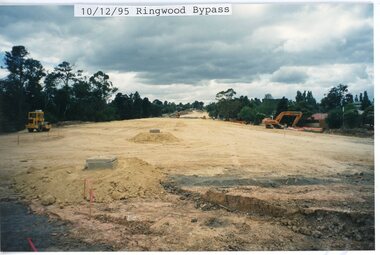
photograph, Eastlink Ringwood Bypass Construction-Ringwood Bypass 10/12/95
Colour photographWritten on back of photo: "Ringwood Bypass-Looking toward Mt Dandenong Rd" -
 Ringwood and District Historical Society
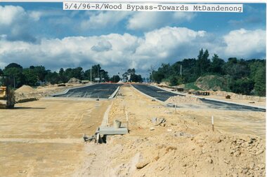
photograph, Eastlink Ringwood Bypass Construction- Ringwood Bypass-Towards Mt Dandenong 5/4/96
Colour photographWritten on back of photo: "Ringwood Bypass-Looking towards Mt dandenong Road 5/4/96" -
 Ringwood and District Historical Society
Photograph, Insulator Works. Mt Dandenong Rd Ringwood East. 1940
Black and white photograph"Attached to front of photograph" INSULATOR WORKS Mt Dandenong Rd - Ringwood East. 1940 -
 Ringwood and District Historical Society
Photograph, Maroondah Highway. The house at the corner of George Road. Taken from the South side near the junction of Mt Dandenong Road on 10th September 1989, 1989
Digital photograph -
 Ringwood and District Historical Society
Photograph, Maroondah Highway. The house at the corner of George Road. Taken from the South side near the junction of Mt Dandenong Road on 10th September 1989, 1989
Digital photograph -
 Ringwood and District Historical Society
Photograph, Ringwood corner Maroondah and Mt Dandenong Road on 10Sep1989. Daisy’s hotel viewed from Georges Road corner
Digital photograph -
 Ringwood and District Historical Society
Photograph, Ringwood corner Maroondah and Mt Dandenong Road on 10Sep1989
Digital photograph -
 Ringwood and District Historical Society
Photographs, Suda and Khassa Ave Ringwood, Before and after Ringwood Bypass Construction 1993
B&W photograph taken by Ringwood Historical Research Group. Also added extract from Melways showing the roads before the Bypass (1987) showing the planned Bypass cutting these two roads, and Melways (2018) showing new alignment with Bypass11063A: 17.1.93 Suda Ave Still intact towards Maroondah Hwy. Taken near Khassa Pde 11063B: 17.1.93 Suda Ave. House gone. Near Khassa Pde 11063C: 17.1.93 Ringwood Bypass from cnr Khassa Pde and Suda Ave towards Mt Dandenong Rd 11063D: 17.2.93 Suda Ave. House gone. 11063E: 21.2.93 cnr Khassa Pde and Suda Ave. Direction of next cut for the Ringwood Bypass. Trees to go. 11063F: 21.2.93 Connection from ??? St to North end of Suda Ave 11063G: 22.2.93 Adelaide St to right (closed). Mile Ave in front and turning left. Note the grey wall along Miles St to support the new car park development. Shrub on left is in the bowling club. -
 Eltham District Historical Society Inc
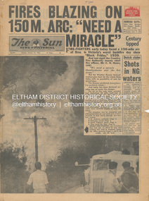
Newspaper - Newspaper articles, Sun News-Pictorial, Fires Blazing on 150M. Arc: "Need a Miracle", The Sun News-Pictorial, Tuesday, January 16, p1, 1962
Various news articles pertaining to the January 1962 Victorian bushfires in the Dandenong and Healesville districts which by second day had spread on to a 150 mile front fromDaylesford and Kinglake through to the Dandenongs. Specific Eltham Shire districts mentioned include Ninka Road, St. Andrews, Kinglake, Hurstbridge on page 2 • Fires Blazing on 150M. Arc: "Need a Miracle", p1 (Illust.) – Victoria’s worst bushfire day since “Black Friday,” 1939 • Night dash as bushfire sweeps by, p2 (Illust.) • Kalorama Saved: Fire 100 Ft. Away, p2 • Stay away, says police chief, p2 • The Tragedy of the Fires, p3 (Illust.) • Good save by firemen, p4 (Illust.) • S.E.C. Firemen Saved N. Yallourn, p4 • Cherry river of flame, p4 • From the fire front: Fire-fighters are bitten by snakes, p4 • They faced the fury, p6 (Illust.) • The ’39 Blaze, p6 • They fought and failed, p6 • Hills Aflame: 2nd Day, pp16-17 (Illust.) • Respite at Olinda HQ, p16 (Illust.) • Here is Ruin, p17 (Illust.) • This fireman had to work among piled up furniture … p32 (Illust.) tom fielding collection, victorian bushfires - 1962, victorian bushfires – 1962, black friday, victorian bushfires – 1939, c.h. howe, daylesford, country fire authority, dandenongs, yallourn, central gippsland, montrose, olinda, kalorama, healesville, st. andrews, hurstbridge, ninka road, kinglake, yarra glen, a.l. mccutcheon, st. andrews postmaster, eltham shire secretary, max watson, police commissioner porter, observatory road, mt. dandenong, whittlesea, one tree hill, sassafras, the basin, steel’s creek, ruby ryan, the basin progress hall, yaallourn, yallourn north, stet electricity commission (s.e.c.), hernes oak, mcdonalds track, florence milkins, lieutenant-colonel k. leggett, bonza view road, ringwood police station, michael o’connor, volunteers, fire damage - buildings