Showing 87 items matching "mt dandenong north"
-
 Mt Dandenong & District Historical Society Inc.
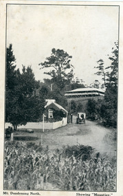
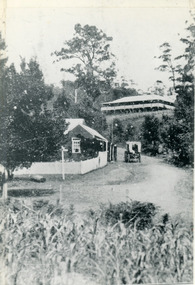
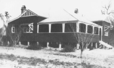
Photograph, Mt Dandenong North. Showing "Mountjoy"
... Mt Dandenong North. Showing "Mountjoy".......mt dandenong north...The building burned down in 1975. Mt. Dandenong North was renamed Kalorama in 1926....On front ; Mt. Dandenong North. Showing "Mountjoy."...The building burned down in 1975. Mt. Dandenong North was renamed Kalorama in 1926. postcard mountjoy guest house beulah tea room beulah mt dandenong north kalorama On front ; Mt. ...The building with the white picket fence is the Beulah Tea Gardens opened by Eliza Hand c1904 at The Gap (now FiveWays). The building is still operating as a cafe. The Tourist Road does not yet exist. Old Coach Road comes into the picture from the right and the horse and cart is heading up Ridge Road. The elm trees can be seen on the left. The building up on the hill is the Mountjoy Guest House. ‘Mountjoy’ was built by the Paynter family in 1905. It had fourteen bedrooms, a dining room and sitting room, kitchen with a big wood burning range and verandahs on three sides. There were commanding views of the eastern ranges and the city to the west. Ellis Jeeves purchased ‘Mountjoy’ in 1908 and it soon became a popular tourist destination, the coach yards making it a centre of the district. ‘Mountjoy’ is a central feature of many photographs of Kalorama in the 1900s. The building burned down in 1975. Mt. Dandenong North was renamed Kalorama in 1926.Black and white postcard showing a horse and cart on road between two buildings.On front ; Mt. Dandenong North. Showing "Mountjoy."postcard, mountjoy, guest house, beulah tea room, beulah, mt dandenong north, kalorama -
 Mt Dandenong & District Historical Society Inc.
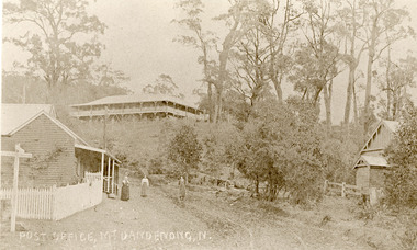
Photograph, Post Office Mt Dandenong North c1911, c1911
... Post Office Mt Dandenong North c1911......Mt Dandenong North...Post Office Mt Dandenong North c1911 Photograph ...Landscape view. Mountjoy on hill, post office and residence with fence and sign post. Mrs Eliza Hand and (probably) Miss Florence hand outside. Another person standing on Ridge Road on the left. On right, the Methodist Church.eliza hand, florence hand, methodist church, mountjoy, mt dandenong north, post office, ridge road -
 Ringwood and District Historical Society
Framed photograph, William Cook Pioneer of Ringwood and Mt Dandenong North c 1914
... William Cook Pioneer of Ringwood and Mt Dandenong North c 1914...Photo of William Cook who was a pioneer in Ringwood and lived in Mt Dandenong North at one time c.1914....Ringwood and District Historical Society 125A Warrandyte Road Ringwood North melbourne Photo of William Cook who was a pioneer in Ringwood and lived in Mt Dandenong North at one time c.1914. Back of frame inscribed William Cook, Pioneer. ...Photo of William Cook who was a pioneer in Ringwood and lived in Mt Dandenong North at one time c.1914.Coloured photograph in wooden frame with buff coloured inset +Additional Keywords: Cook, WilliamBack of frame inscribed William Cook, Pioneer. -
 Mt Dandenong & District Historical Society Inc.
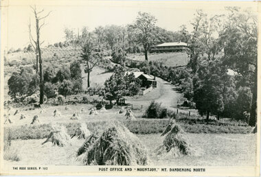
Photograph, Post Office and 'Mountjoy', Mt. Dandenong North, 1913
... Post Office and 'Mountjoy', Mt. Dandenong North...Haystacks in foreground with Mountjoy Guest House and Beulah Tea Rooms/Mt Dandenong North Post Office in centre. This photograph has a detailed inscription on the back handwritten by John Lundy-Clarke in 1974....Post Office and 'Mountjoy', Mt. Dandenong North Photograph ...Rose Series post card #182Copy of Rose Series postcard #182 showing Kalorama Gap in 1913. Haystacks in foreground with Mountjoy Guest House and Beulah Tea Rooms/Mt Dandenong North Post Office in centre. This photograph has a detailed inscription on the back handwritten by John Lundy-Clarke in 1974.Kalorama Gap in 1913 The elm trees are in the centre of the picture. One of these is really two as two suckers of the further tree were twisted together by Fred Jeeves in 1898 and grew as one tree. The other was planted in 1880. The shop is the shop of Mrs Eliza Hand and daughter Florence. The closed in far end of the verandah was the Mount Dandenong North Post Office. The large house is “Mountjoy” owned and run by the Jeeves Family from 1908 till 1943. It was built in 1905 by the Paynters who sold to Ellis Jeeves in 1908.He moved his line of coaches from “Kalorama” his old homestead and housed the horses in a line of stables behind “Mountjoy”. Price’s house, which contained their shop, the first one on the mountain, opened 1906, can be seen faintly behind the pine tree opposite the bend in the road, which was the main road then and now is Ridge Road. The Price’s house just shows in two tiny pieces, one on each side of the pine tree half way up. The house to the right of and high up the pine tree is Walker’s cottage which exists today opposite Jack Kidd’s home at the far edge of Lt 2 Village Settlement and was between Main Road and Barbers Road which runs down the left behind the elms. Walker’s homestead can be seen near left edge of picture 2/3 way up. The roof of the Methodist Church shows among trees left of picture. This, like Mrs Hand’s shop was built on portions separated from Isaac Jeeves’ Selection “C” known as Jeeves Saddle. kalorama gap, five ways, mountjoy, john lundy-clarke, beulah tea rooms, post office, fred jeeves, paynter, jeeves, frederick jeeves, price, walker, jack kidd -
 Mt Dandenong & District Historical Society Inc.
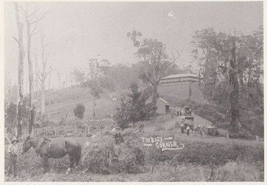
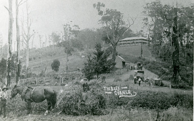
Photograph, 'The Busy Corner' FiveWays c1909, c1909
... ...Mt Dandenong North...Landscape view of Ridge and Barbers Roads showing Mountjoy Guest House on crest, Mt Dandenong North Post Office, three delivery carts and people. ...Mt Dandenong & District Historical Society Inc. Farndons Community Hall 42 Falls Road Mt Dandenong yarra-valley-and-the-dandenong-ranges Mountjoy Ridge Road FiveWays Barbers Road Frederick Jeeves Mt Dandenong North Post Office Theo Hand Landscape view of Ridge and Barbers Roads showing Mountjoy Guest House on crest, Mt Dandenong North Post Office, three delivery carts and people. ...Landscape view of Ridge and Barbers Roads showing Mountjoy Guest House on crest, Mt Dandenong North Post Office, three delivery carts and people. Lower LH corner Fred Jeeves (standing), Theo Hand (on wagon) and Blossom (horse).mountjoy, ridge road, fiveways, barbers road, frederick jeeves, mt dandenong north, post office, theo hand -
 Mt Dandenong & District Historical Society Inc.
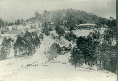
Photograph, The Gap Under Snow 1921, 1921
... ...Mt Dandenong North...New CRB road formation (unmetalled) comes into picture lower left corner, passes left of dray under the elms, then circles around behind the trees behind Miss Hands shop and home and Post Office (Mt Dandenong North) to pass out of picture left in centre of picture. ...Mt Dandenong & District Historical Society Inc. Farndons Community Hall 42 Falls Road Mt Dandenong yarra-valley-and-the-dandenong-ranges John Lundy-Clarke Kalorama Mountjoy MountJoy The Gap Post Office Mt Dandenong North Snow The Gap under snow 1921. ...Snow scene looking up through The Gap (FiveWays) with Mountjoy Guest House on the hill to the right. The shop and post office are seen in the centre of the picture. This photograph has a detailed inscription on the back handwritten by John Lundy-Clarke in 1974.The Gap under snow 1921. “Mountjoy” on hill. New CRB road formation (unmetalled) comes into picture lower left corner, passes left of dray under the elms, then circles around behind the trees behind Miss Hands shop and home and Post Office (Mt Dandenong North) to pass out of picture left in centre of picture. It passes between Ted Prices Hay & Corn store and Walker’s house where the Estate Agency was later placed. Main Road then in centre of picture bend right behind Mountjoy. Price’s house and shop behind the blackwood left of road bend. CRB cuts across Barbers left of Elm trees.john lundy-clarke, kalorama, mountjoy, mountjoy, the gap, post office, mt dandenong north, snow -
 Mt Dandenong & District Historical Society Inc.
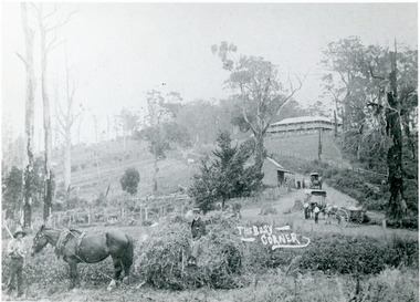
Photograph, The Busy Corner, 1907
... ...mount dandenong north...mt...Isaac Jeeves special strip of land Crown Allotment “C” 7 chains wide, lay between the sledge load of pea stalks and the far end of the verandah on Mrs Hand’s “Beulah Tea Rooms” which soon afterwards became the Mt Dandenong North Post Office. The coach road came up from the right behind the tall stump. ...Mt Dandenong & District Historical Society Inc. Farndons Community Hall 42 Falls Road Mt Dandenong yarra-valley-and-the-dandenong-ranges jeeves theo hand fred jeeves isaac jeeves barbers road beulah tea rooms post office mount dandenong north mt dandenong north kalorama coach mountjoy “Jeeves Saddle” in 1907. ...View of Jeeves Saddle in 1907 showing everyday life and including important people and businesses from early settlement - Dodd's grocery and meat cutting carts; Beulah tea Rooms/Post Office; Mrs Hand, Fred Jeeves, Theo Hand.This photograph has a detailed inscription on the back handwritten by John Lundy-Clarke in 1974.“Jeeves Saddle” in 1907. Isaac Jeeves special strip of land Crown Allotment “C” 7 chains wide, lay between the sledge load of pea stalks and the far end of the verandah on Mrs Hand’s “Beulah Tea Rooms” which soon afterwards became the Mt Dandenong North Post Office. The coach road came up from the right behind the tall stump. The big woman in black was Mrs Hand. The wagon at the shop was Dodd’s grocery cart. The nearer wagon was the first coach on the mountain which had belonged to Briarty. The small cart was Dodd’s meat cutting cart. The elm trees are in the centre of the picture and above them is Price’s sign advertising their shop and newsagency. The big house is “Mountjoy” burnt 1975. Walker’s house is among the big trees left centre. Boy at horse’s head is Fred Jeeves. Boy on sledge is Theo Hand. The horse is “Blossom”. Barbers Road goes to the left from behind the elm trees.jeeves, theo hand, fred jeeves, isaac jeeves, barbers road, beulah tea rooms, post office, mount dandenong north, mt dandenong north, kalorama, coach, mountjoy -
 Mt Dandenong & District Historical Society Inc.
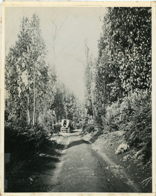
Photograph, Jeeves Coach on CRB Road at Foot of Farringdon Road Kalorama, 1920, 1920
... ...mt dandenong north...Jeeves Coach on CRB road at foot of Farringdon Road Kalorama (Mt Dandenong North) 1920. Road was formed most of the length from Montrose by contractors Bladin and Dick employing Robert Logan the younger, in 1919 and lay unmetalled till metalled by the contractors in 1922. ...Mt Dandenong & District Historical Society Inc. Farndons Community Hall 42 Falls Road Mt Dandenong yarra-valley-and-the-dandenong-ranges coach service jeeves crb road farringdon road kalorama mt dandenong north mt dandenong tourist road john lundy-clarke coach Jeeves Coach on CRB road at foot of Farringdon Road Kalorama (Mt Dandenong North) 1920. ...Scene looking down Farringdon Road showing Jeeves horse drawn coach going along the CRB road (Mt Dandenong Tourist Road) in 1920. Detailed inscription on the back handwritten by John Lundy-Clarke in 1974.Jeeves Coach on CRB road at foot of Farringdon Road Kalorama (Mt Dandenong North) 1920. Road was formed most of the length from Montrose by contractors Bladin and Dick employing Robert Logan the younger, in 1919 and lay unmetalled till metalled by the contractors in 1922. Mountain ash trees in foreground were on Thomas Hand’s original 23 acre holding. Those beyond coach were on Isaac Jeeves original 160 acre holding Selection Crown Allotment 925(B). This was the area forming part of the inheritance lost by John William Richardson because of the expense of his wife’s illness. Hand enlarged his 23 acres to 305 in 1874. William and his family grew large crops of raspberries on his area, part of which is in the foreground. It had been cleared by his father’s employees before 1877. The section below the Main Road was cultivated by Fred hand, son of William and grandson of Thomas in the twenties before he moved to Redcliffes where he is today (1974). Comment by John Lundy-Clarke 10.5.1974 coach service, jeeves, crb road, farringdon road, kalorama, mt dandenong north, mt dandenong tourist road, john lundy-clarke, coach -
 Mt Dandenong & District Historical Society Inc.
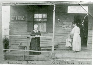
Photograph, Grandma Hand, Gert and Aunt Florrie at Kalorama Post Office c1910, c1910
... ...Mt Dandenong North...Mt Dandenong & District Historical Society Inc. Farndons Community Hall 42 Falls Road Mt Dandenong yarra-valley-and-the-dandenong-ranges Eliza Hand Florence Hand FiveWays Mt Dandenong North Post Office Tea Rooms Gertrude Badenhop Kalorama Post Office (Mt Dandenong Nth) at Five Ways c1910. ...Kalorama Post Office (Mt Dandenong Nth) at Five Ways c1910. The building is "Beulah Tea Rooms" which had some post office services. Grandma Hand - Eliza Hand nee Erith is in the white bonnet. Gert - Gertrude Badenhop is her grand-daughter with Florrie Hand - later Mrs Walker.eliza hand, florence hand, fiveways, mt dandenong north, post office, tea rooms, gertrude badenhop -
 Mt Dandenong & District Historical Society Inc.
Photograph, The Gap at Kalorama 1913, 1913
... ...Mt Dandenong North...Mt Dandenong & District Historical Society Inc. Farndons Community Hall 42 Falls Road Mt Dandenong yarra-valley-and-the-dandenong-ranges FiveWays Mountjoy Post Office Mt Dandenong North The Gap Jeeves coach The Gap Kalorama 1913. ...1913 scene looking up to Mountjoy Guest House at the Kalorama Gap (FiveWays). Post Office and tea rooms with white picket fence. Jeeves Coach on the road. This photograph has a detailed inscription on the back handwritten by John Lundy-Clarke in 1974. The Gap Kalorama 1913. ‘Mountjoy’ guest house. Mount Dandenong North Post Office. Jeeves coach.fiveways, mountjoy, post office, mt dandenong north, the gap, jeeves, coach -
 Mt Dandenong & District Historical Society Inc.
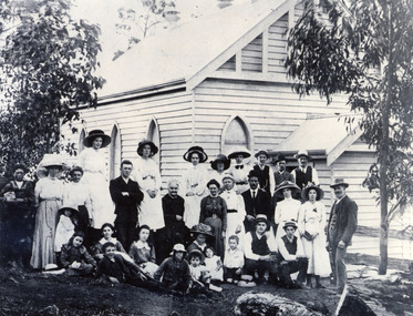
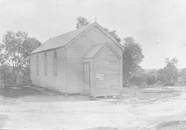
Photograph, Congregation of Kalorama Methodist Church 1911
... The area was known as Mt Dandenong North until 1926 when the name was changed to Kalorama. ...Mt Dandenong & District Historical Society Inc. Farndons Community Hall 42 Falls Road Mt Dandenong yarra-valley-and-the-dandenong-ranges Congregation gathered for photograph at front of Kalorama Methodist Church at FiveWays. The area was known as Mt Dandenong North ...Congregation gathered for photograph at front of Kalorama Methodist Church at FiveWays. The area was known as Mt Dandenong North until 1926 when the name was changed to Kalorama. The people assembled are all members of the local community. The church was built by the community in 1910.Black and white photograph showing a group of 31 people gathered in front of a wooden church building.kalorama, methodist church -
 Mt Dandenong & District Historical Society Inc.
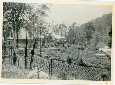
Photograph, View of Kalorama Gap 1905
... Mrs Hand’s “Beulah Tearooms” later Mt Dandenong North Post Office is above Price’s roof....Mrs Hand’s “Beulah Tearooms” later Mt Dandenong North Post Office is above Price’s roof. ...Kalorama Gap viewed from the South West in 1908. Ellis Jeeves' 'Mountjoy' is in the centre with the stables to the left. The raspberry patch belongs to Harry Walker and the building centre right to Edward Joseph Price. John Lundy-Clarke grew up in the Kalorama/Mt Dandenong area and later in life (1972-74) began to write a comprehensive history of the area working from an original settlement map in an effort to cover all areas.Black and white photograph showing an extensive raspberry crop in the foreground with a house and outbuilding in the centre and another dwelling centre right. Handwritten description on reverse by John Lundy-Clarke. 1908 view of Kalorama Gap taken from corner of Village Settlement LOTS 2 and 3 on Ridge (then Main Road) which crosses centre of picture with Walker’s driveway dropping left. Walker’s raspberry patch in foreground. “Mountjoy” in centre of picture with coaching stables on left. Price’s house and shop on right showing large cross room used by the Village Settlers for dancing. Mrs Hand’s “Beulah Tearooms” later Mt Dandenong North Post Office is above Price’s roof.kalorama gap, kalorama, harry walker, walker, edward joseph price, raspberry, mountjoy -
 Mt Dandenong & District Historical Society Inc.
Photograph, The Busy Corner, 1907
... The shop was Hand's Beulah Tea Rooms soon to become the Mt Dandenong North Post Office. Big woman in black was Mrs Hand. wagon was Dodd's Grocery cart. ...Mt Dandenong & District Historical Society Inc. Farndons Community Hall 42 Falls Road Mt Dandenong yarra-valley-and-the-dandenong-ranges Mountjoy beulah tea rooms Fred Jeeves Theo Hand Dodd's Grocery cart cart coach Briartys The Kalorama Gap in 1907. The coach road comes from right behind old stump. The shop was Hand's Beulah Tea Rooms soon to become the Mt Dandenong North ...View of Kalorama gap taken in 1907 showing Eliza Hand outside Beulah Tea Rooms, Briartys Coach, Dodd's Grocery cart and Meat Cutting cart. In foreground Fred Jeeves is standing and Theo Hand on hay. Mountjoy is in the background.This photograph has a detailed inscription on the back handwritten by John Lundy-Clarke in 1974.The Kalorama Gap in 1907. The coach road comes from right behind old stump. The shop was Hand's Beulah Tea Rooms soon to become the Mt Dandenong North Post Office. Big woman in black was Mrs Hand. wagon was Dodd's Grocery cart. "Mountjoy" on hilltop. The wagon with man was the first coach on the mount (Briartys). Small cart was Dodd's meat cutting cart. Horse at sledge was "Blossom" boy at her head was Fred Jeeves. Boy on sledge was Theo hand. Elm trees in centre of picture with Prices sign advertising shop and newsagency above them.mountjoy, beulah tea rooms, fred jeeves, theo hand, dodd's grocery cart, cart, coach, briartys -
 Kiewa Valley Historical Society
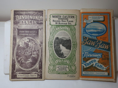
Maps - Tourist
... Dandenong Ranges. Brown cover. dated 6-4-33. Govt. printer showing roads, tracks in red and heights of the land. 2. Tourist Map of Warburton, Mt Baw Baw, and Walhalla. Blue and Orange cover. dated 23-5-33 Govt. printer. 3 different maps of each area showin roads, tracks and timber tramways.Also in red and blue. 3. Tourist Map of North...Dandenong Ranges. Brown cover. dated 6-4-33. Govt. printer showing roads, tracks in red and heights of the land. 2. Tourist Map of Warburton, Mt Baw Baw, and Walhalla. Blue and Orange cover. dated 23-5-33 Govt. printer. 3 different maps of each area showin roads, tracks and timber tramways.Also in red and blue. 3. Tourist Map of North ...These maps were all dated 1933 which was before the construction of the Kiewa Hydro Electric Scheme and when Tawonga was spelt Towonga. North East Victoria in 1933 was before the construction of the Kiewa Hydro Electric Scheme so the townships of Mt Beauty and Bogong are not shown. The description of the Snow Lines was important as skiers, bushwalkers and campers relied on them. The details on the map include "ADB. Numbered from A.1-377 round plates. CD Numbered from C 1-235 square plates. Poles about 3 chains apart 27 to the mile." 3 Tourist location maps (folded) and printed on parchment. 1. Tourist map of the Dandenong Ranges. Brown cover. dated 6-4-33. Govt. printer showing roads, tracks in red and heights of the land. 2. Tourist Map of Warburton, Mt Baw Baw, and Walhalla. Blue and Orange cover. dated 23-5-33 Govt. printer. 3 different maps of each area showin roads, tracks and timber tramways.Also in red and blue. 3. Tourist Map of North Eastern Victoria including Bogong High Plains Mt Buffalo Etc. Green cover. dated June 1933 Govt. printer. Main map and insert titled Bogong High Plains. Showing roads , tracks and tram ways. On insert showing snow poles. Also Red and Blue and mountains.By Authority of H.J. Green - 6 pence. Dept of Lands and Survey, Melbourne1933 maps, tourism maps, bogong high plains map 1933, snow poles -
 Eltham District Historical Society Inc
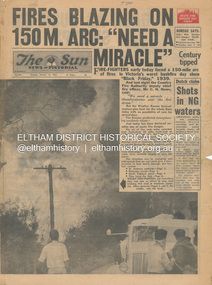
Newspaper - Newspaper articles, Sun News-Pictorial, Fires Blazing on 150M. Arc: "Need a Miracle", The Sun News-Pictorial, Tuesday, January 16, p1, 1962
... Mt. Dandenong...Whittlesea...One Tree Hill...Sassafras...The Basin...Steel’s Creek...Ruby Ryan...The Basin Progress Hall...Yaallourn...Yallourn North...Mt. Dandenong Whittlesea One Tree Hill Sassafras The Basin Steel’s Creek Ruby Ryan The Basin Progress Hall Yaallourn Yallourn North Stet Electricity Commission (S.E.C.) ...Various news articles pertaining to the January 1962 Victorian bushfires in the Dandenong and Healesville districts which by second day had spread on to a 150 mile front fromDaylesford and Kinglake through to the Dandenongs. Specific Eltham Shire districts mentioned include Ninka Road, St. Andrews, Kinglake, Hurstbridge on page 2 • Fires Blazing on 150M. Arc: "Need a Miracle", p1 (Illust.) – Victoria’s worst bushfire day since “Black Friday,” 1939 • Night dash as bushfire sweeps by, p2 (Illust.) • Kalorama Saved: Fire 100 Ft. Away, p2 • Stay away, says police chief, p2 • The Tragedy of the Fires, p3 (Illust.) • Good save by firemen, p4 (Illust.) • S.E.C. Firemen Saved N. Yallourn, p4 • Cherry river of flame, p4 • From the fire front: Fire-fighters are bitten by snakes, p4 • They faced the fury, p6 (Illust.) • The ’39 Blaze, p6 • They fought and failed, p6 • Hills Aflame: 2nd Day, pp16-17 (Illust.) • Respite at Olinda HQ, p16 (Illust.) • Here is Ruin, p17 (Illust.) • This fireman had to work among piled up furniture … p32 (Illust.) tom fielding collection, victorian bushfires - 1962, victorian bushfires – 1962, black friday, victorian bushfires – 1939, c.h. howe, daylesford, country fire authority, dandenongs, yallourn, central gippsland, montrose, olinda, kalorama, healesville, st. andrews, hurstbridge, ninka road, kinglake, yarra glen, a.l. mccutcheon, st. andrews postmaster, eltham shire secretary, max watson, police commissioner porter, observatory road, mt. dandenong, whittlesea, one tree hill, sassafras, the basin, steel’s creek, ruby ryan, the basin progress hall, yaallourn, yallourn north, stet electricity commission (s.e.c.), hernes oak, mcdonalds track, florence milkins, lieutenant-colonel k. leggett, bonza view road, ringwood police station, michael o’connor, volunteers, fire damage - buildings -
 Eltham District Historical Society Inc
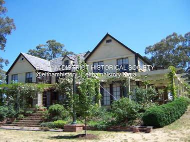
Photograph - Digital Photograph, Marguerite Marshall, Jelbart home, 93 Arthur Street, Eltham, 11 November 2006
... Mt. Dandenong to the south-east, the Great Divide to the north, and Melbourne city to the south-west. ...Mt. Dandenong to the south-east, the Great Divide to the north, and Melbourne city to the south-west. ...Situated at the top of the hill in Arthur Street, the former Jelbart residence and barn were part of a major change that transformed Eltham's character in the late 1960s. Built from the mid 1940s through mid 1950s when Eltham was a rural community, the Jelbart residence and barn are all that remain of a family property of some 250 acres (100 ha). With growing population pressures, in the late 1960s, owners Ron and Yvonne Jelbart decided to subdivide their property creating the Woodridge Estate in the early 1970s, a major factor towards the transformation of Eltham to the suburb it is today. The Jelbarts had moved to Eltham in the early 1940s when they purchased a poultry farm in New Street, now Lavendar Park Road. (The local Black Friday bushire of January 13, 1939 had started at C.A. (Clarrie) Hurst’s Eltham Poultry Farm and Hatchery in New Street.) Jelbart was primarily a businessman importing office machinery but desired farm beef and dairy cattle so the couple purchased the virgin bushland at what was then at the end of a dirt road, Arthur Street. With post war shortages of most building materials, they followed the example of the Eltham Artists' Colony (later called Montsalvat) and built their home from mud-bricks and recycled materials. The barn was first to be completed in 1945 which they made their home whilst building the main residence. It took eight years to complete the two buildings. Both the main residence and the barn are now separate homes, and along with the remaining property being sub-divided further in 1998 are now part of the Kinloch Gardens Estate at 93 Arthur Street. Covered under Heritage Overlay, Nillumbik Planning Scheme. Published: Nillumbik Now and Then / Marguerite Marshall 2008; photographs Alan King with Marguerite Marshall.; p139 Standing on a hilltop at Arthur Street, Eltham, the Jelbart residence and former barn were part of a major change that transformed Eltham’s character in the late 1960s. Built from the late 1940s to the mid 1950s when Eltham was a rural community, they are all that remain of what was once a family property of around 250 acres (100 ha). As population pressure increased in the late 1960s, owners Ron and Yvonne Jelbart, decided to subdivide their property. The break-up of this property into the Woodridge Estate in the early 1970s, was a major factor towards transforming Eltham into the suburb it is today.1 Although standing only a few minutes from Eltham’s busy hub and hundreds of houses in Woodridge, scarcely any urban sound disturbs the peace. Views from the two buildings are almost exclusively of trees and extend to Mt. Dandenong to the south-east, the Great Divide to the north, and Melbourne city to the south-west. The Jelbarts had lived in Eltham since the early 1940s when they bought a poultry farm in New Street, now Lavender Park Road. Although Jelbart was primarily a businessman importing office machinery, he was keen to farm dairy and beef cattle, so the couple bought rough bushland at what was then the end of Arthur Street. But a shortage of building materials following World War Two hampered their plans to build their new home, so they followed the example of the Eltham Artists’ Colony (later called Montsalvat) and used mud-bricks and recycled materials.2 With great determination the family and friends constructed their house. Massive timber frames and huge quantities of mud-bricks were made on site. The barn was built first in 1945, and two years later, while camping inside, the Jelbarts started building their house. It took eight years to construct the two buildings, even with the help of professional tradesmen. The buildings, with timber frames infilled with mud-brick and plastered, are reminiscent of the English Tudor style. The Jelbarts are of Cornish stock. Much of the timber framework came from demolished bridges or warehouses, and recycled slate was used for roofs and floors. Quality second-hand materials were readily available in the late 1940s and 1950s when there was much demolition in Melbourne and little respect for heritage. A former 19th century Toorak mansion Woorigoleen provided the magnificent stone fireplace, the timber panelling and the parquetry floor in the living room. The large stone gateposts at the entry of the property came from Melbourne University. Almost no mechanical equipment was used to build the 55 square house and the 25 square barn. Massive timber frames were erected using block and tackle pulleys and timbers were shaped, sawn and drilled by hand. Son and architect Ian, with his family, have lived in and extensively renovated both buildings since the early 1970s. Ian transformed the steep ridge of the property into a plateau, where the main house Kinloch stands, surrounded by terraces and lawns. The grounds retain many native plants, including massive yellow boxes – some nudging 80 years. Ian attached 70 metres of pergolas draped with wisteria, roses and grape vines, to three sides of the house. The beautiful garden is featured in the book Through the Rose Arbour by Rosemary Houseman. The two-storey barn – now a house – retains traces of its original use. The cow-shed with milking and feed-rooms, and the machinery-shed remain. The house, separated on the ground floor by a breeze-way, soars two storeys and includes a mezzanine. These are connected by spiral staircases, to timber-beamed and plaster-lined high-pitched ceilings. The house also descends to a wine cellar. Curiously the roof is of corrugated iron on the south and slate on the north, to save costs. Small-paned windows and three French doors open onto the front lawn, which extends to Jelbart Court.This collection of almost 130 photos about places and people within the Shire of Nillumbik, an urban and rural municipality in Melbourne's north, contributes to an understanding of the history of the Shire. Published in 2008 immediately prior to the Black Saturday bushfires of February 7, 2009, it documents sites that were impacted, and in some cases destroyed by the fires. It includes photographs taken especially for the publication, creating a unique time capsule representing the Shire in the early 21st century. It remains the most recent comprehenesive publication devoted to the Shire's history connecting local residents to the past. nillumbik now and then (marshall-king) collection, eltham, arthur street, jelbart barn, jelbart home, kinloch gardens -
 Ringwood and District Historical Society
Photograph, United Methodist Free Church Ringwood- 1904
... Ringwood and District Historical Society 125A Warrandyte Road Ringwood North melbourne Typed below large copy: "United Methodist Church 1904 - Cnr. Mt. Dandenong Rd. & Whitehorse Road." ...Black and white photograph (2 copies- 1 original mounted on lightly embossed cardboard, 1 larger copy)Typed below large copy: "United Methodist Church 1904 - Cnr. Mt. Dandenong Rd. & Whitehorse Road." -
 Ringwood and District Historical Society
Photograph, William Maggs portrait, and photo of the Maggs home in Queensland. c1923
... North melbourne Two photographs. Written on back of photograph P0112(a): "The home of the late William Maggs, at The Summit, Queensland, close to the NSW border". Written on back of photograph P0112(b): "William Maggs, youngest son of the late Joseph Maggs, Mt. Dandenong ...Black and white photographsTwo photographs. Written on back of photograph P0112(a): "The home of the late William Maggs, at The Summit, Queensland, close to the NSW border". Written on back of photograph P0112(b): "William Maggs, youngest son of the late Joseph Maggs, Mt. Dandenong Rd., Ringwood East, Victoria. -
 Ringwood and District Historical Society
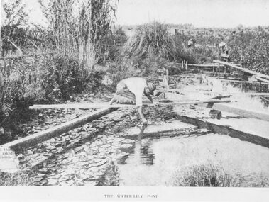
Photograph, The Water-Lily Pond at Hill's Flower Farm, Ringwood, in 1905, 1905
... Ringwood and District Historical Society 125A Warrandyte Road Ringwood North melbourne Water Lillies Flower Farming Typed under photograph: The Water Lily Pond. Mr Hill's flower farm, Mt Dandenong Rd. ...Black and white photograph (2 copies)Typed under photograph: The Water Lily Pond. Mr Hill's flower farm, Mt Dandenong Rd. Later Howship's. In area around Howship Street. Written on back of one image: 'Australasian' 29/3/05. John Hill's flower farm, Mt Dandenong Rd. Later Howship's flower farm subdivided, name retained in street name. Pool was part of Sandy Gully Creek 1905.water lillies, flower farming -
 Ringwood and District Historical Society
Photographs, Ringwood Fire Station at 255 Maroondah Highway circa 1998
... Ringwood and District Historical Society 125A Warrandyte Road Ringwood North melbourne This fire station was closed and a new one opened on Maroondah Highway on the site of the old miner's cottage near the corner of the Highway and Mt Dandenong Road. ...This fire station was closed and a new one opened on Maroondah Highway on the site of the old miner's cottage near the corner of the Highway and Mt Dandenong Road.Five coloured photographs of the Ringwood fire station at 255 Maroondah Highway and of the fireman's house when it was sold. It later became 'The Fire Station Restaurant.' -
 Ringwood and District Historical Society
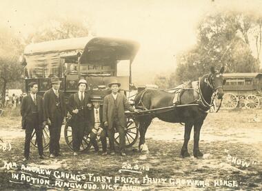
Photograph, Andrew Chung, Orchardist, of Mt. Dandenong Rd Ringwood. 1913
... North melbourne Agriculture Written on original photograph- "Mr. Andrew Chung's first prize, Fruit Growers Horse in Action. Ringwood. Vict. Aust. 22.3.13." Typed beneath one copy- "Andrew Chung, Orchardist, of Mt. Dandenong ...Sepia photograph (original), with 3 black and white copies. Photographer- George Wall & Co Photo Experts, 131 Chapel Sr, Balaclava.Written on original photograph- "Mr. Andrew Chung's first prize, Fruit Growers Horse in Action. Ringwood. Vict. Aust. 22.3.13." Typed beneath one copy- "Andrew Chung, Orchardist, of Mt. Dandenong Rd. 1913"agriculture -
 Ringwood and District Historical Society
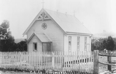
Photograph, Roman Catholic Church, Ringwood.1915 (Built 1893)
... Ringwood and District Historical Society 125A Warrandyte Road Ringwood North melbourne Typed below photograph: "Roman Catholic Church - Whitehorse Rd. opposite Mt. Dandenong ...Black and white photograph (2 copies)Typed below photograph: "Roman Catholic Church - Whitehorse Rd. opposite Mt. Dandenong Rd. intersection - 1915" Written on back of another copy: "Built 1893 at (one stage) in grounds of R.C. School." -
 Ringwood and District Historical Society
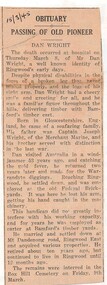
Newspaper - Obituary, Death of Ringwood resident, Dan Wright on March 8, 1945
... North melbourne Born in Gloucestershire, England ... Settled in Ringwood and was employed at the old Federal Brickyards. It was here that he lost his arm, getting his hand caught in machinery. This handicap did not greatly interfere with his working capacity, and for years he was employed as carter at Bamford's timber yards. He married and settled down at Mt Dandenong ...Local newspaper clipping - 15/3/1945 - Passing of Old Pioneer.Born in Gloucestershire, England ... Settled in Ringwood and was employed at the old Federal Brickyards. It was here that he lost his arm, getting his hand caught in machinery. This handicap did not greatly interfere with his working capacity, and for years he was employed as carter at Bamford's timber yards. He married and settled down at Mt Dandenong Road, Ringwood East and acquired various properties. Interred Box Hill Cemetery on Friday, 9th March. -
 Ringwood and District Historical Society
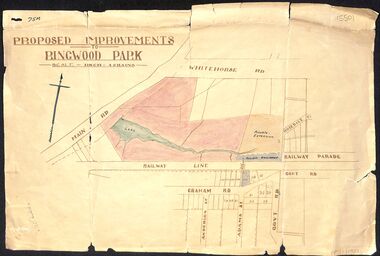
Map, Proposed Improvements to Ringwood Park (Ringwood Lake) dated 14 January 1927
... Ringwood and District Historical Society 125A Warrandyte Road Ringwood North melbourne Proposed Improvements to Ringwood Park (Ringwood Lake) dated 14 January 1927, signed Cr McCaskill. Main Road is Whitehorse Road (Maroondah Highway), and Mt Dandenong Road is incorrectly labelled Whitehorse Road. ...Proposed Improvements to Ringwood Park (Ringwood Lake) dated 14 January 1927, signed Cr McCaskill. Main Road is Whitehorse Road (Maroondah Highway), and Mt Dandenong Road is incorrectly labelled Whitehorse Road. The map shows Rosedale Crescent and Railway Parade, both of which exist in 2024. On the bottom of the map, south of the railway line, showing proposed streets - Graham Road, Anderson Street and Adams Street - in preparation for the sale of the Theo Anderson property. That area is now Bedford Park. -
 Ringwood and District Historical Society
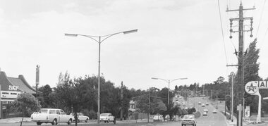
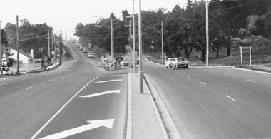
Photograph, Maroondah Highway East, Ringwood- 1971. Looking east towards Mt Dandenong Road
... Ringwood and District Historical Society 125A Warrandyte Road Ringwood North melbourne Written on back of photograph: "Maroondah Highway, looking east towards Mt Dandenong Road turnoff past lake. 1971." ...Black and white photographWritten on back of photograph: "Maroondah Highway, looking east towards Mt Dandenong Road turnoff past lake. 1971." -
 Ringwood and District Historical Society
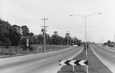
Photograph, Maroondah Highway East, Ringwood- 1965. Corner of Mt Dandenong Road before widening
... Ringwood and District Historical Society 125A Warrandyte Road Ringwood North melbourne Typed note on back of photograph: "M'dah Hwy, June 1965, before it was widened from Mt Dandenong on." ...Black and white photograph (3 separate images)Typed note on back of photograph: "M'dah Hwy, June 1965, before it was widened from Mt Dandenong on." -
 Ringwood and District Historical Society
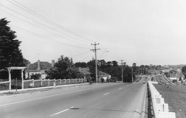
Photograph, Maroondah Highway East, Ringwood- 1969. Looking west towards Ringwood approaching Mt Dandenong Road
... Ringwood and District Historical Society 125A Warrandyte Road Ringwood North melbourne Black and white photograph Maroondah Highway East, Ringwood- 1969. Looking west towards Ringwood approaching Mt Dandenong Road. ...Black and white photograph -
 Ringwood and District Historical Society
Photograph, Maroondah Highway East, Ringwood- 1969. Looking west towards Ringwood from Mt Dandenong Road intersection
... Ringwood and District Historical Society 125A Warrandyte Road Ringwood North melbourne Written on back of photograph: "Nov 1969, Cnr Mt Dandenong Road and Maroondah Highway." ...Black and white photographWritten on back of photograph: "Nov 1969, Cnr Mt Dandenong Road and Maroondah Highway." -
 Ringwood and District Historical Society
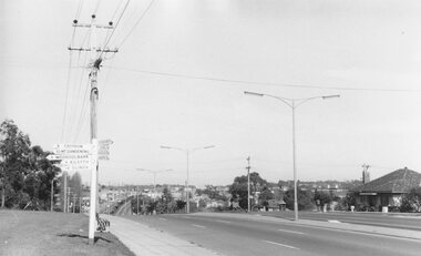
Photograph, Maroondah Highway East, Ringwood- 1969. Looking west towards Ringwood from Mt Dandenong Road
... Ringwood and District Historical Society 125A Warrandyte Road Ringwood North melbourne Written on back of photograph: "Cnr Maroondah Highway and Mt Dandenong Road. ...Black and white photographWritten on back of photograph: "Cnr Maroondah Highway and Mt Dandenong Road. Nov 1969." -
 Ringwood and District Historical Society
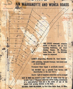
Map, Partially Trimmed Copy of Ringwood Heights Estate, Ringwood, Vic. - circa 1923
... Ringwood and District Historical Society 125A Warrandyte Road Ringwood North melbourne Sales notations on numbered allotments in Andersons's Creek Road (later Warrandyte Road) and Wonga Road, Ringwood. Handwritten title reference - LP7305. Captions - This Estate commands extensive views of mountain, hill and dale including Dandenong and Great Dividing Ranges, Mt. ...Clipped copy of a subdivision advertisement on cardboard backing. Sales notations on numbered allotments in Andersons's Creek Road (later Warrandyte Road) and Wonga Road, Ringwood. Handwritten title reference - LP7305. Captions - This Estate commands extensive views of mountain, hill and dale including Dandenong and Great Dividing Ranges, Mt. Macedon, Keilor Plains, etc. The outlook cannot be surpassed. Climate invigorating, mountain air, good rainfall. Land undulating, splendid drainage; soil, sandy loam on gravel subsoil. Permanent water supply is practically assured. The district has a splendid train service, with electrification in the near future. Electric light & telephone connection can be arranged. Keep in mind this estate is only 1 mile 25 chains from the up-to-date town of Ringwood which has all the trading conveniences of a semi-suburban town and is the centre of one of the largest fruit growing districts in the state. Distance from Melbourne by first class motor road, 16 miles.