Showing 6 items matching "myrtle park estate"
-
 Kew Historical Society Inc
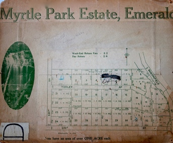
Plan - Subdivision Plan, Myrtle Park Estate, Emerald, 1915
... Myrtle Park Estate, Emerald......myrtle park estate...This subdivision plan for the ‘Myrtle Park Estate’ relates to land sales in Emerald, Victoria, rather than to the subdivision of the same name in East Kew (1913-16). ...Kew Historical Society Inc Kew Court House 188 High Street Kew melbourne subdivision plans - emerald myrtle park estate Torley Road -- Emerald (Vic.) This subdivision plan for the ‘Myrtle Park Estate’ relates to land sales in Emerald, Victoria, rather than to the subdivision of the same name in East Kew (1913-16). ...This subdivision plan for the ‘Myrtle Park Estate’ relates to land sales in Emerald, Victoria, rather than to the subdivision of the same name in East Kew (1913-16). The subdivision in Emerald included 32 one-acre lots facing Torley Road, Government Road (now Rawhiti and Wong Hee Roads) Beaconsfield Road (now Old Beaconsfield Road). On the plan, an unnamed creek flows through allotments 8-12 on the east side of the Estate. The photograph of a waterfall and the advertised price of Day Return and Weekend Return Fares provide an indication of who the prospective purchasers were likely to be.subdivision plans - emerald, myrtle park estate, torley road -- emerald (vic.) -
 Kew Historical Society Inc
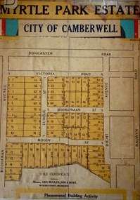
Plan - Subdivision Plan, Myrtle Park Estate, City of Camberwell, 1916
... Myrtle Park Estate, City of Camberwell......myrtle park estate - camberwell [surrey hills]...The ‘Myrtle Park Estate’ was a subdivision bounded by Victoria Road (now Lansdowne Street), Buchanan Avenue and Dight Avenue. ...Barnes. subdivision plans - balwyn myrtle park estate - camberwell [surrey hills] The ‘Myrtle Park Estate’ was a subdivision bounded by Victoria Road (now Lansdowne Street), Buchanan Avenue and Dight Avenue. ...The Kew Historical Society collection includes almost 100 subdivision plans pertaining to suburbs of the City of Melbourne. Most of these are of Kew, Kew East or Studley Park, although a smaller number are plans of Camberwell, Deepdene, Balwyn and Hawthorn. It is believed that the majority of the plans were gifted to the Society by persons connected with the real estate firm - J. R. Mathers and McMillan, 136 Cotham Road, Kew. The Plans in the collection are rarely in pristine form, being working plans on which the agent would write notes and record lots sold and the prices of these. The subdivision plans are historically significant examples of the growth of urban Melbourne from the beginning of the 20th Century up until the 1980s. A number of the plans are double-sided and often include a photograph on the reverse. A number of the latter are by noted photographers such as J.E. Barnes.The ‘Myrtle Park Estate’ was a subdivision bounded by Victoria Road (now Lansdowne Street), Buchanan Avenue and Dight Avenue. Other streets that were created by the subdivision included Eurolie Street, Boorahman Street and Moody Street (now Sylvan Street). The Estate took its name from Myrtle Park (later changed to Macleay Park), which had been created in 1923 by Camberwell Council. The Park adjoined the southeast corner of the new subdivision. The Estate included 74 regular allotments characterised by narrow frontages and long blocks. Confusion may have greeted prospective purchasers as the Estate was advertised in the daily newspapers as being in East Kew, rather than in Camberwell, where it was at that stage located.subdivision plans - balwyn, myrtle park estate - camberwell [surrey hills] -
 Glen Eira Historical Society
Photograph - Elsternwick
... Estate Agents... Classic Cinema Theatres... St. George’s Road... Elizabeth Street... Allison Road... Gladstone Park... Myrtle...Rothells Sausage Factory North Road Red Bus Service Transport Furlonger Miss Dance Studio Moran and Cato Grocery Cato family Newsagent Tozer Brook Furniture Store Green Gables American style soda fountain and milk bar Hoyts Renown Theatre State Savings Bank Riddell Parade Clarence Street Aileen Avenue Smith Keith James Camden Town Sports club Peer Gary Gary Peer & Associates Brukarz Jack Ray White Real Estate Real Estate Agents Classic Cinema Theatres St. George’s Road Elizabeth Street Allison Road Gladstone Park Myrtle Street Victoria Street Caulfield St Kilda East Lisbon House Orrong Road House names Rippon Lea Estate Caulfield South Carnegie Gordon Street Carre Street Main Street Clarence Street Elsternwick Club Jewish Holocaust Museum Daily Planet Brothels Wesley College Elsternwick Primary St. ...This file contains three items. Photocopied and three page retyped article, undated c.1930s and source unknown from Real Estate Agent Philippe Batters 03/09/1997. Three page document from Keith James Smith, undated, on research on Elsternwick and Glen Huntly Road shops and traders. Three articles from THE AGE 13/05/2000 and 15-16/02/2013 and MELB BAYSIDE WEEKLY 03/11/2010 giving snap shots of Elsternwick housing and facts.batters philippe, real estate agents, elsternwick, paddocks, glen huntly road, walter kelly, elsternwick park, slaughter yards, glen eira roads, point ormond, glenhuntly railway station, nepean highway, grange road, holdsworth’s jewellers, staniland grove, coles store, shops, orrong road, fosseys, hattams mensware, woolworths, dalgarnos crockery and kitchenware, chapmans gifts, garth’s shoe store, garth jack, allen’s furniture and auction rooms, elsternwick market, adam’s cakes, mr. green’s pet shop, turner mr., grocer shop, moores lendring library, hopetown gardens, gardens, jack hatheralls butchershop, butchers, chinese laundry, chinese community, laundries, mr. & mrs. darbyshires milkbar, st. johns church, kooyong road, hasseles garage, garages, royal parade, glenhuntly, camden, hawthorn road, blacksmiths, camden town, dolls hospital, caulfield state school 773, independent picture, theatres, camden theatre, southern indoor bowl centre, larch street, montessorie school, collins milk bar, milk bars, collins lin, hartrick miss, armond mr., lennie mr., rothells sausage factory, north road, red bus service transport, furlonger miss, dance studio, moran and cato grocery, cato family, newsagent, tozer brook, furniture store, green gables american style soda fountain and milk bar, hoyts renown theatre, state savings bank, riddell parade, clarence street, aileen avenue, smith keith james, camden town, sports club, peer gary, gary peer & associates, brukarz jack, ray white real estate, real estate agents, classic cinema theatres, st. george’s road, elizabeth street, allison road, gladstone park, myrtle street, victoria street, caulfield, st kilda east, lisbon house, orrong road, house names, rippon lea estate, caulfield south, carnegie, gordon street, carre street, main street, clarence street, elsternwick club, jewish holocaust museum, daily planet, brothels, wesley college, elsternwick primary, st. joseph’s primary, scholem aleichen college, liebler yavneh, hopetoun gardens, harleston park -
 Ringwood and District Historical Society
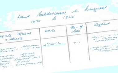
Document - Research Notes, Richard Carter, Land Subdivisions in Ringwood 1890-1950
... (1920) Eastfield Road, Longview Road, Pleasant Rise, The Mount Pg10 ELECTRIC RAILWAY ESTATE RINGWOOD LP9473 (1922) Campbell Street, Myrtle Avenue, George Street (now Tudor Court), Henry Street (now Myrtle Avenue), Williams Grove (now Lena Grove) Pg11 RINGWOOD PARK ESTATE LP7884 (1922 - two stages) Wonga Road (now Loughnan Road), William Street, Andrew Street, Harrison Street Pg12 HEATHMONT STATION ESTATE LP11009 (Date? ...(1920) Eastfield Road, Longview Road, Pleasant Rise, The Mount Pg10 ELECTRIC RAILWAY ESTATE RINGWOOD LP9473 (1922) Campbell Street, Myrtle Avenue, George Street (now Tudor Court), Henry Street (now Myrtle Avenue), Williams Grove (now Lena Grove) Pg11 RINGWOOD PARK ESTATE LP7884 (1922 - two stages) Wonga Road (now Loughnan Road), William Street, Andrew Street, Harrison Street Pg12 HEATHMONT STATION ESTATE LP11009 (Date? ...Handwritten table listing main local pre-1950s subdivisions in the Ringwood area, with estate names, streets, number of allotments for sale, and where known, vendor agent, LP (Lodged Plan) title registration number, and auction/sale date, some with sale price.Pg1 RINGWOOD STATION ESTATE LP3070 (Year?) Station Street, William Street (now Kendall Street), Wantirna Road, Station Street Pg1 RINGWOOD TOWNSHIP ESTATE LP5577 (1913) Station Road (now Warrandyte Road), Pratt Street (part now Aird Street), Whitehorse Road Pg2 RINGWOOD ORCHARD ESTATE LP4315 (1914) Brysons Road, Hillcrest Road, Anzac Avenue, Sulva Road Pg3 RINGWOOD RAILWAY ESTATE LP7522 (1918) Whitehorse Road (now Mount Dandenong Road), Dublin Road, Freeman Street, Patterson Street, Bona Street Pg4 THE RINGWOOD ESTATE LP7578 (1919) Warrandyte Road, Hobart Street, Paxton Street, Arnold Street Pg5 GARDEN FARMS ESTATE (LP?) (1919) Canterbury Road, Armstrong Road, Bungalook Road, Orchard Road, Bayswater Road (now Mountain Highway) Pg6 THE RINGWOOD ESTATE (SECOND SUB-DIVISION) LP7604 (1919) Warrandyte Road, Tamar Street, Derwent Street, Mersey Street Pg7 RINGWOOD STATION ESTATE LP7703 (1919) Bedford Road, Williams Grove (now Lena Grove) Pg8 RINGWOOD TOWNSHIP ESTATE LP8198 (1919) Wantirna Road, Ellison Street, Haig Street, Greenwood Avenue Pg9 EASTFIELD ESTATE (LP?) (1920) Eastfield Road, Longview Road, Pleasant Rise, The Mount Pg10 ELECTRIC RAILWAY ESTATE RINGWOOD LP9473 (1922) Campbell Street, Myrtle Avenue, George Street (now Tudor Court), Henry Street (now Myrtle Avenue), Williams Grove (now Lena Grove) Pg11 RINGWOOD PARK ESTATE LP7884 (1922 - two stages) Wonga Road (now Loughnan Road), William Street, Andrew Street, Harrison Street Pg12 HEATHMONT STATION ESTATE LP11009 (Date? - after 1922) Lisgoold Street, Viviani Crescent, Balrour Avenue, Station Street (now part Heathmont Road and part Wainui Street) Pg13 RINGWOOD RAILWAY ESTATE LP10507 (1923) Whitehorse Road, Sherbrooke Avenue, Burwood Avenue, Bonview Avenue, Heatherbrae Avenue, Grant Crescent Pg14 GARDEN HOMES ESTATE (LP?) (1923) Mullum Road, The Centreway, Wattle Crescent (now Wattle Avenue) Reserve Crescent (now Reserve Road) Pg15 DUBLIN ROAD ESTATE LP11993 (1923) Alexandra Road, Vonadawn Avenue, Green Street, Wood Street, Howard Avenue, Bedford Road, Dublin Road Pg16 CARLINGA ESTATE RINGWOOD LP9620 (1923) Bourke Street, Bond Street, Ringwood Street Pg17 PRATT'S JUNCTION ESTATE (LP?) (1923) Junction Street, Georges Road, Oliver Street, Whitehorse Road Pg18 EAST RINGWOOD ESTATE LP10492 (1923) Bona Street, Patterson Street, Miller Grove, Fairview Avenue, Eastfield Road, Whitehorse Road (now Mount Dandenong Road) Pg19 COLEMAN'S HEATHMONT ESTATE LP9974 (1923) Canterbury Road, Bedford Road, Alvena Crescent, Coleman Street, Leonard Street (now Royal Avenue) Pg20 RINGWOOD HEIGHTS ESTATE LP10506 (1924) Whitehorse Road, Bonview Avenue, Grant Crescent, Hillcrest Avenue, Heatherbrae Avenue, Margaret Street, Mary Street Pg21 EAST RINGWOOD STATION ESTATE LP10551 (1924) Knaith Road, Wenwood Street, Lois Street, Victoria Street, Station Street (now Railway Avenue) Pg22 GRAND VIEW ESTATE LP11019 (1924) Whitehorse Road, Rupert Street, Herbert Street, Leonard Street Pg23 RINGWOOD RAILWAY ESTATE & RINGWOOD HEIGHTS ESTATE - FINAL SECTIONS LP10506 & LP10507 (1924) Whitehorse Road, Sherbrooke Avenue, Burwood Avenue, Bonview Avenue, Heatherbrae Avenue, Margaret Street, Mary Street, Grant Crescent Pg24 RINGWOOD EAST ELECTRIC STATION ESTATE (LP?) (1924) Railway Parade (now Patterrson Street), Federal Road, Howship Avenue (part now French Street), Dublin Road, Rosedale Crescent Pg25 BEDFORD PARK (now Ringwood Secondary College) (LP?) (1924) Bedford Road, Adams Street, Anderson Street, Joyce Street, Graham Road Pg26 CROWN JEWEL ESTATE LP11645 (Private sales after 1924) Mount Dandenong Road, Mirabel Avenue, Valda Avenue, Evon Avenue, Velma Grove Pg27 GRAND CENTRAL ESTATE LP10917 (1925) Heathmont Road, Great Ryrie Street, Douglas Street, Garden Street, Bellevue Avenue Pg28 RINGWOOD (unnamed estate - 1926) Nelson Street, Seymour Street, Whitehorse Road Pg29 EAST RINGWOOD RAILWAY STATION ESTATE (YEAR? - 25 shops 60 villas) Railway Avenue, Dublin Road, Lawrence Grove, Stanley Avenue, Knaith Road Pg30 CHARM VIEW ESTATE (LP?) (year? - after 1926) Canterbury Road, Heathmont Road, Dickasons Road, Bennjett Avenue, Orchid Street Pg31 SUNBEAM ESTATE LP12150 (Circa 1925) Govt Road (now Old Lilydale Road), Sunbeam Avenue, Holland Road, Everard Street (now Everard Road) Pg32 FAIRVIEW ESTATE EAST RINGWOOD LP10853 (Circa 1924) Eastfield Road, Patterson Street, Margaret Street (now Short Street) Pg33 EAST RINGWOOD TOWNSHIP ESTATE LP3025 (Circa 1924 - 35 allotments) Mount Dandenong Road, Grey Street, Eastfield Road Pg34 EAST RINGWOOD TOWNSHIP ESTATE LP3025 (Circa 1924 - 49 allotments) and STATE SCHOOL ESTATE (26 allotments) and EAST RINGWOOD STATION ESTATE (14 shop sites) Mount Dandenong Road, Grety Street, Dunn Street, Eastfield Road, King Street, Holland Road, Dublin Road, Patterson Street, Bona Street Pg35 EAST RINGWOOD CENTRAL ESTATE LP17004 (1948) Knaith Road, Shasta Avenue, Talofa Avenue, Russet Road, Dublin Road Pg36 WARE ESTATE LP43360 (1958) Ware Crescent, Davey Drive, Grey Road (now Grey Street), Mount Dandenong Road Pg37 Lot 57 Kendall Street LP3070 (1939) £75.0.0 Pg37 Lot 14 LP7346 (year?) £225 Pg37 Lot 8 WHITE HORSE ESTATE LP14010 (year?) Maroondah Hwy, Seymour Street £98.9.0 Pg37 Lots 4-14 incl. LP10902 (year?) £300 Pg37 Lots 69&70 LP2216 (1939) Bedford Road, Pitt Street £500 Pg37 Lots 60&70 LP2216 (year?) £460 Pg37 MOUNTAIN VIEW ESTATE LP10902 (1936) Lots 1&2, 19-22 Wantirna Road, Daisy Street £50 Pg38 RAILWAY STATION ESTATE RINGWOOD EAST LP7522 (1925) Lots 16 to 19 £250 Pg38 RINGWOOD PARK ESTATE (LP?) (1924) Lot 112 Munro Street £230 Pg38 RINGWOOD TOWNSHIP ESTATE (LP?) (1925) Lot 57 Wantirna Road £850 Pg38 ELECTRIC RAILWAY ESTATE LP9473 (1925) Lot 98 & 99 £180 (30/- foot) Pg38 ELECTRIC RAILWAY ESTATE LP9473 (year?) Lot 100 £233.12.6 incl improvements (£2.12.6 foot) Pg38 Lot 22&23 Bedford Road Heathmont (LP & year?) £675 incl improvements Pg39 Lot 9 Mullum Mullum Road LP8221 (1923) £150 Pg39 Lot 27 Haig Street LP8198 (1925) £825 Pg39 Lot 56 Haig Street cnr Wantirna Road LP8198 (1923) £171 Pg39 Lots 3 & 4 Loughnan Road LP9626 (192?) £147 Pg39 Lots 98 & 99 Myrtle Avenue LP9473 (1925) £180 Pg39 Lots 80 & 81 Myrtle Avenue LP9473 (1929) £150 Pg39 Lot 30 Sherbrooke Avenue LP10507 (1926) £700 incl improvements Pg40 Lot 10 (year?) LP7703 £750 Pg40 Lot 36 (year?) LP7522 £25 Pg40 Lot 38 Pitt Street LP2216 (year?) £350 Pg40 Lot 7 Dublin Road cnr Green Street LP11993 (year?) £300 -
Kew Historical Society Inc
Archive (Sub-series) - Subject File, Kew Historical Society, Houses [Kew], 1980
... Myrtle Hill, and an article on the restoration of Mynda, Molesworth Street that was published in the Trust News (1987). Mrs Sewell of Stawell Street wrote handwritten notes/recollections about Cradley in Studley Park Road in 1981. In the photocopy about Ellesmore, there is also a separate article on the proposed replacement of the Walmer Street Bridge. There is also correspondence and an article on Stanhope on the corner of Burke and Cotham Roads. The file includes general real estate...Myrtle Hill, and an article on the restoration of Mynda, Molesworth Street that was published in the Trust News (1987). Mrs Sewell of Stawell Street wrote handwritten notes/recollections about Cradley in Studley Park Road in 1981. In the photocopy about Ellesmore, there is also a separate article on the proposed replacement of the Walmer Street Bridge. There is also correspondence and an article on Stanhope on the corner of Burke and Cotham Roads. The file includes general real estate ...Various partiesReference, Research, InformationSecondary Values (KHS Imposed Order)Assorted printed materials, some published, such as: ‘What House is That? A guide to Victorian housing’ (Heritage Victoria, 2004), and guidelines for researching the history of a house (Fact Sheet, City of Boroondara). There is an article from the Progress Press about the demolition of Ellesmore, 80 Princess Street in 1977 (the article includes photographs of the demolition), Elizabeth Mackie’s notes on Myrtle Hill, and an article on the restoration of Mynda, Molesworth Street that was published in the Trust News (1987). Mrs Sewell of Stawell Street wrote handwritten notes/recollections about Cradley in Studley Park Road in 1981. In the photocopy about Ellesmore, there is also a separate article on the proposed replacement of the Walmer Street Bridge. There is also correspondence and an article on Stanhope on the corner of Burke and Cotham Roads. The file includes general real estate information and data.kew historical society - archives, kew - history, myrtle hill (kew), ellesmore - 80 princess street - kew (vic), mynda - molesworth street - kew (vic), stanhope - burke road - cotham road - kew (vic), cradley - studley park road - kew (vic), 17 queen street - kew (vic.)kew historical society - archives, kew - history, myrtle hill (kew), ellesmore - 80 princess street - kew (vic), mynda - molesworth street - kew (vic), stanhope - burke road - cotham road - kew (vic), cradley - studley park road - kew (vic), 17 queen street - kew (vic.) -
 Whitehorse Historical Society Inc.
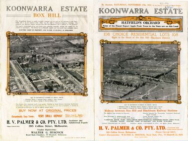
Document - Real Estate Notice, Koonwarra Estate Hatfield's Orchard, C1924
... estate...hatfield's orchard...middleborough road...blackburn...canterbury road...laburnum street...hillside crescent...salisbury avenue...rymer street...pakenham street...park street...myrtle...Whitehorse Historical Society Inc. 2-10 Deep Creek Road Mitcham melbourne land sales koonwarra estate hatfield's orchard middleborough road blackburn canterbury road laburnum street hillside crescent salisbury avenue rymer street pakenham street park street myrtle grove h. v. palmer & co. pty. ltd. hiscock walter g Land brochure giving details of auction of Koonwarra Estate Land brochure giving details of auction of Koonwarra Estate known as Hatfield's Orchard Koonwarra Estate Hatfield's Orchard Document Real Estate Notice ...Land brochure giving details of auction of Koonwarra EstateLand brochure giving details of auction of Koonwarra Estate known as Hatfield's OrchardLand brochure giving details of auction of Koonwarra Estate land sales, koonwarra estate, hatfield's orchard, middleborough road, blackburn, canterbury road, laburnum street, hillside crescent, salisbury avenue, rymer street, pakenham street, park street, myrtle grove, h. v. palmer & co. pty. ltd., hiscock, walter g