Showing 26 items matching "national mapping"
-
 Bendigo Military Museum
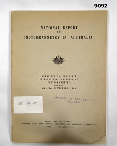
Administrative record - Report on Photogrammetry in Australia 1960 - Division of National Mapping, Division of National Mapping, Department of National Development, September 1960
... Report on Photogrammetry in Australia 1960 - Division of National Mapping...Report on Photogrammetry in Australia 1960 - Division of National Mapping......Division of National Mapping...This National Report on Photogrammetry in Australia was prepared and submitted to the Ninth International Congress of Photogrammetry held in London during September 1960. Chapters deal with Mapping...Division of National Mapping, Department of National Development...Report on Photogrammetry in Australia 1960 - Division of National Mapping Administrative record Report on Photogrammetry in Australia 1960 - Division of National Mapping Division of National Mapping, Department of National Development ...This National Report on Photogrammetry in Australia was prepared and submitted to the Ninth International Congress of Photogrammetry held in London during September 1960. Chapters deal with Mapping activities by various Australian Organisations including the Royal Australian Survey Corps. This comprehensive report details the status of mapping and aerial photography in Australia in 1960 including 14 Annexes. An A4 sized buff coloured card covered paper report of 68 pages and stapled. There is a property Card inside the front cover titled "Historical Property Record". Stamped "SCHOOL OF MILITARY SURVEY" on the front cover and first page. Sticker has hand written "526 982 DIV"royal australian survey corps, rasvy, fortuna, army survey regiment, army svy regt, asr, division of national mapping -
 Bendigo Military Museum
Administrative record - Division of National Mapping - Specification for Vertical Aerial Photography, Division of National Mapping, 1963
... Division of National Mapping - Specification for Vertical Aerial Photography...Division of National Mapping - Specification for Vertical Aerial Photography...Commonwealth of Australia, Department of Defence of National Development, Division of National Mapping Specification. This is a Specification for Aerial Photography acquisition and is written for civilian contract work....Division of National Mapping...Royal Australian Survey Corps RASvy Fortuna Army Survey Regiment Army Svy Regt ASR 8 x A4 poor photocopies of typed pages Division of National Mapping - Specification for Vertical Aerial Photography Administrative record Division of National Mapping - Specification for Vertical Aerial Photography Division of National Mapping ...Commonwealth of Australia, Department of Defence of National Development, Division of National Mapping Specification. This is a Specification for Aerial Photography acquisition and is written for civilian contract work.8 x A4 poor photocopies of typed pagesroyal australian survey corps, rasvy, fortuna, army survey regiment, army svy regt, asr -
 Bendigo Military Museum
Administrative record - Advisory Committee on Commonwealth Mapping Meeting Notes - (National Mapping Council Meetings), Circa 1972
... Advisory Committee on Commonwealth Mapping Meeting Notes - (National Mapping Council Meetings)...Advisory Committee on Commonwealth Mapping Meeting Notes - (National Mapping Council Meetings)......National Mapping...Submission 8 National Mapping Survey and Mapping Co-ordination. .4 Air photography and Mapping Programme 1956/57. ...Advisory Committee on Commonwealth Mapping (ACOCM) Meeting Notes. 15 Items of typed pages and diagrams. .1 Letter 22 July 1954 .2 Letter 17 Feb 1955 .3 Letter 22 July 1955 .4 letter 26 Jan 1956 .5 Letter Hon WS Kent Hughes Minister for the Interior ACT .6 National Mapping Programme 1956/57 .7 Clarifies Army participation in Cabinet Decision No2 (VP) .8 History of National Mapping 24 Apr 1958 .9 Report on Army Committee on National Mapping 2 July 1958 .10 RASvy Brief Review of Activities Jan - Dec 1964 .11 Advisory Committee Meeting Notes 12 Feb 1965 - Agenda item 8 .12 Advisory Committee Meeting Notes 12 Feb 1965 - Agenda item 8 para 5.1.3 - 11.2 .13 ACOCM Meeting Agenda 1968 .14 ACOCM Meeting Minutes 1970 .15 Letter to Mr B White CBE Secretary from LF Bott...Submission 8 National Mapping Survey and Mapping Co-ordination. .4 Air photography and Mapping Programme 1956/57. ...Advisory Committee on Commonwealth Mapping (ACOCM) Meeting Notes. 15 Items of typed pages and diagrams. .1 Letter to the Hon WS Kent Hughes MVO, OBE, Mc, ED, MP, Minister for the Interior, ACT Signed Jos Francis. Cabinet Decision taken on 22 July 1954, effects on current military mapping agreements between AUS, UK and USA. Australian responsibility "Noted was the fact that RASvy was in preparation for War." .2 Letter by H Wells Lieutenant General, Chief of the General Staff, 17 Feb 1955. Refers to the invitation of Major General RL Brown UK Defence to visit Australia to help align the mapping programme. .3 Draft Cabinet Submission on National Mapping Survey and Mapping Co-ordination of the 22 July 1955. Attachment 1 Cabinet Minute, Vice-President's letter Canberra22 July 1954. Decision No2 (VP). Submission 8 National Mapping Survey and Mapping Co-ordination. .4 Air photography and Mapping Programme 1956/57. Signed by LF Fitzgerald OBE Director of Military Survey 26 Jan 56. .5 Letter Hon WS Kent Hughes MVO, OBE, MC, ED, MP. Minister for the Interior ACT. Confirming the Cabinet Decision No2 (VP) Signed by Joe Francis .6 National Mapping Programme 1956/57. States a view to Army's contribution to this programme .7 Clarifies Army participation in Cabinet Decision No2 (VP) .8 History of National Mapping Asst Secretary (General) 24 Apr 1958 .9 Report on Army Committee on National Mapping. 2 July 1958 .10 RASvy Brief Review of Activities Jan - Dec 1964 .11 Advisory Committee on Commonwealth Mapping Meeting Notes 12 Feb 1965 - Agenda item 8. This endorsed the principle of grouping Commonwealth Mapping Agencies in a Survey Mapping Group in Canberra which included AHQ Survey Regiment. This did not come to fruition. .12 Advisory Committee on Commonwealth Mapping Meeting Notes 12 Feb 1965 - Agenda item 8 para 5.1.3 - 11.2 .13 ACOCM Meeting Agenda 1968 .14 ACOCM Meeting Minutes 1970 .15 Letter to Mr B White CBE Secretary from LF BottAdvisory Committee on Commonwealth Mapping (ACOCM) Meeting Notes. 15 Items of typed pages and diagrams. .1 Letter 22 July 1954 .2 Letter 17 Feb 1955 .3 Letter 22 July 1955 .4 letter 26 Jan 1956 .5 Letter Hon WS Kent Hughes Minister for the Interior ACT .6 National Mapping Programme 1956/57 .7 Clarifies Army participation in Cabinet Decision No2 (VP) .8 History of National Mapping 24 Apr 1958 .9 Report on Army Committee on National Mapping 2 July 1958 .10 RASvy Brief Review of Activities Jan - Dec 1964 .11 Advisory Committee Meeting Notes 12 Feb 1965 - Agenda item 8 .12 Advisory Committee Meeting Notes 12 Feb 1965 - Agenda item 8 para 5.1.3 - 11.2 .13 ACOCM Meeting Agenda 1968 .14 ACOCM Meeting Minutes 1970 .15 Letter to Mr B White CBE Secretary from LF Bottroyal australian survey corps, rasvy, fortuna, army survey regiment, army svy regt, asr, national mapping -
 Bendigo Military Museum
Administrative record - Geodetic Survey and Topographical Mapping in Australia - Report by BP Lambert 1968, 1968
... ...National Mapping...National coordination of their respective geodetic survey and topographic mapping activities is effected on the advice of a National Mapping Council. ...Geodetic Survey and Topographic Mapping a Report by BP Lambert Director of National Mapping, Department of National Development, Canberra, Australia, 1968....BP Lambert, Director of National Mapping, Canberra...National coordination of their respective geodetic survey and topographic mapping activities is effected on the advice of a National Mapping Council. ...Australia is governed by a Federal Government and by six State Governments. National coordination of their respective geodetic survey and topographic mapping activities is effected on the advice of a National Mapping Council. Twenty years ago, at least 95% of Australia was poorly mapped and what maps existed were in need of revision. only a small area of the continent was covered by horizontal geodetic control and there was no scheme for a national levelling survey. Over the intervening period there has been an urgent and increasing demand for topographic maps varying from large scale contoured maps in support of specific engineering projects to rapid reconnaissance maps required for mineral prospecting in remote areas. Superimposed on this has been a defence requirement, specifically for military training areas, and generally for maps of the whole country. During the period much progress has been made. This paper reports on the progress from early colonial days through to the present time and finally hazards a prediction of future trends.Photocopy of 18-page typed report including diagrams, stapled top left-hand corner. Geodetic Survey and Topographic Mapping a Report by BP Lambert Director of National Mapping, Department of National Development, Canberra, Australia, 1968.royal australian survey corps, rasvy, fortuna, army survey regiment, army svy regt, asr, national mapping -
 Bendigo Military Museum
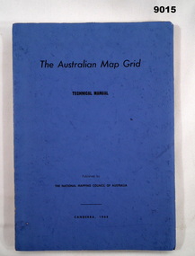
Manual - Australian Map Grid Technical Manual, National mapping Council of Australia, Canberra, 1968
... ...National Mapping Council of Australia...The Australian Map Grid Technical Manual published by The National Mapping Council of Australia, Canberra, 1968. ...National mapping Council of Australia, Canberra...The Australian Map Grid Technical Manual published by The National Mapping Council of Australia, Canberra, 1968. ...In 1966, all geodetic surveys in Australia and New Guinea were recomputed and adjusted on the new Australian Geodetic Datum (AGD). There was now a homogenous system of coordinates (other than heights) for geodetic survey stations all over Australia, free from discontinuities caused by changes in origin.A A4 blue card covered manual containing 84 Pages of text and diagrams and Graphic Annexes A-J. The Australian Map Grid Technical Manual published by The National Mapping Council of Australia, Canberra, 1968. Bound by 2 x Celco Clips.royal australian survey corps, rasvy, fortuna, army survey regiment, army svy regt, asr, national mapping council of australia -
 Bendigo Military Museum
Administrative record - Use of Military maps for water supply planning, 1962
... State Rivers and water supply Commision, Division of National Mapping...Royal Australian Survey Corps RASvy Fortuna Army Survey Regiment Army Svy Regt ASR State Rivers and Water Supply Commission 5 x A4 pages of typed notes, poorly photocopied Use of Military maps for water supply planning Administrative record Use of Military maps for water supply planning State Rivers and water supply Commision, Division of National Mapping ...These are typed notes on the use of Military maps for water supply planning. This demonstrates the value of Military Mapping containing accurate relief information that can then be used for water supply planning.5 x A4 pages of typed notes, poorly photocopiedroyal australian survey corps, rasvy, fortuna, army survey regiment, army svy regt, asr, state rivers and water supply commission -
 Bendigo Military Museum
Manual - DRAFT SPECIFICATIONS FOR TOPOGRAPHIC MAP SERIES, Specifications for 1:50000 and 1:25000 maps produced in Australia, Circa 1973
... ...National Mapping Council of Australia...Specifications for 1:50000 and 1:25000 maps produced in Australia Manual DRAFT SPECIFICATIONS FOR TOPOGRAPHIC MAP SERIES Royal Ausralian Survey Corps National Mapping Council of Australia ...These draft Specifications set out the Standards for the production of topographic maps within the Commonwealth of Australia at scales of 1:50000 and 1:25000 and are designed to satisfy the basic requirements of both civil and military map users.Hard cover, cloth, Red, 11 Annexes, Supplementary documents.royal australian survey corps, rasvy, fortuna, army survey regiment, asr -
 Bendigo Military Museum
Administrative record - Trilateration with the Tellurometer - GRL Rimington 1958, Department of National Development , ACT, 26 May 1958
... ...Division of National Mapping...This paper is a summary of Electronic distance measurements carried out in 1957 in Central Australia by officers of the division of National Mapping, Department of National Development. ...This paper is a summary of Electronic distance measurements carried out in 1957 in Central Australia by officers of the division of National Mapping, Department of National Development. ...trilateration with the tellurometer by GRL Rimington L.S MIS (Aust) Chief Topographic Surveyor, Department of National Development, Australia. This paper was delivered to the Institute of Surveyors Conference, Brisbane 26 May 1958. This paper is a summary of Electronic distance measurements carried out in 1957 in Central Australia by officers of the division of National Mapping, Department of National Development. Trilateration is a surveying Technique that uses measurements of the sides of triangles to determine relative position.A 11 page foolscap size stapled paper report. Two holed punched with dis-coloured pages due to age.royal australian survey corps, rasvy, fortuna, army survey regiment, army svy regt, asr, division of national mapping, surveying -
 Bendigo Historical Society Inc.
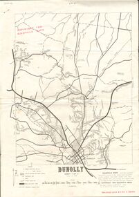
Document - JOAN O'SHEA COLLECTION: DUNNOLLY MAPS, 1980
... GoldField Maps 1980 based on Dunolly 7624 by Division of National Mapping...History House 11 Mackenzie Street Bendigo goldfields GOLD Goldfields goldfield maps dunolly & surrounds GoldField Maps 1980 based on Dunolly 7624 by Division of National Mapping Joan O'Shea Collection. Goldfield Maps Dunolly 3 Sheets 1980. ...Joan O'Shea Collection. Goldfield Maps Dunolly 3 Sheets 1980. Page 1: Mines in Dunolly, Whistling Flat, Painswick and Surrounds. Page 2: Mines in Goldsborough, McKinnons Gap, Bealiba Range, Stewarts Flat and Surrounds. Page 3: Mines in Dunolly, Emu Creek, Bet Bet, Bromley & Surrounds. Scale in Chains and Kilometres.GoldField Maps 1980 based on Dunolly 7624 by Division of National Mappinggold, goldfields, goldfield maps dunolly & surrounds -
 Montmorency–Eltham RSL Sub Branch
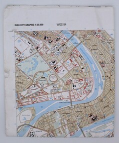
Map, Baghdad
... Prepared and published by the National Imagery and Mapping Agency Copyright 2003 by the United States Government...Montmorency–Eltham RSL Sub Branch Petrie Park 16 Mountain View Road Montmorency melbourne Prepared and published by the National Imagery and Mapping Agency Copyright 2003 by the United States Government map Iraq city Graphic 1:25,000. ...Prepared and published by the National Imagery and Mapping Agency Copyright 2003 by the United States GovernmentPaper, coloured The map is of Baghdad Iraq city Graphic 1:25,000. WGS 84 Edition 11- NIMA Series K941 Sheet 4 Map information as of 2001map -
 Bendigo Military Museum
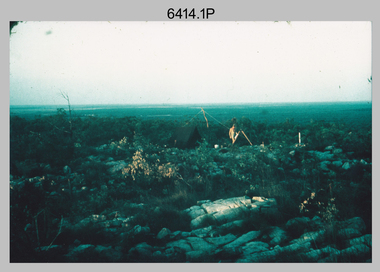
Photograph - Royal Australian Survey Corps Surveyors in the Field – Northern Territory and Queensland, 1959 – 1960
... Laplace observations were necessary in a geodetic network at every 6th survey station, however the National Mapping Council specified at this time the spacing would be ideally between 4-6 survey stations. ...Laplace observations were necessary in a geodetic network at every 6th survey station, however the National Mapping Council specified at this time the spacing would be ideally between 4-6 survey stations. ...This is a set of 10 photographs of surveyors and support staff in the field undertaking duties in the Northern Territory and North Queensland in 1959 – 1960. The surveyors were employed in the establishment of mapping and geodetic control. In this era surveyors used theodolites to observe horizontal and vertical angles and tellurometers to measure base line distances between survey stations. Laplace survey observations seen in Photo .1P was a series of precise observations carried out at geodetic survey stations to determine astronomic latitudes, longitudes and azimuths to achieve maximum precision in the survey network. Laplace observations were necessary in a geodetic network at every 6th survey station, however the National Mapping Council specified at this time the spacing would be ideally between 4-6 survey stations. The cairn shown in photo .4P was built by RASvy as a landmark over a trigonometric survey station. It was dismantled in 1960 to enable re-occupation and survey observations. It was not restored to the condition shown in the photo.This is a set of 10 photographs of surveyors and support staff in the field undertaking duties in the Northern Territory (NT) and Queensland (QLD) in 1959 – 1960. The photographs were printed on photographic paper and are part of the Army Survey Regiment’s Collection. The photographs were scanned at 300 dpi. .1) - Photo, colour, 1959. Tony Slattery occupying a Laplace survey station on a hill in the Mount Young area of the NT. .2) - Photo, colour, 1959. Surveyors’ camp in the Mount Young area of the NT, L to R: Spencer Snow and Tony Slattery. .3) - Photo, colour, 1959. Surveyors’ camp in the Peckman Hill area, near Katherine in the NT. .4) - Photo, colour, 1959. Cairn on Trig Hill, Borroloola, NT. Built by Spencer Snow, Tom Royle and Jack McCabe. .5) - Photo, colour, 1959. Survey party taking a break next to their Austin Champ vehicle, in transit between Katherine, NT and Wyndam WA. L to R: Tony Slattery, Dave Owens, John Van De Graff. .6) - Photo, colour, 1960. Surveyors’ camp between Mount Isa, QLD and Borroloola, NT. L to R: Pat Cox and John Van De Graff prepare their meal on an open fire. .7) - Photo, colour, 1960. Surveyor - Dennis Woods undertaking survey observations, using MRA1 tellurometer to measure base-line distances NW of Mount Isa, QLD. .8) - Photo, colour, 1960. Unidentified surveyors assessing recovery of their stalled Studebaker truck vehicle after attempting a water crossing in the NT. .9) - Photo, colour, 1960. Unidentified surveyor making batches of bread at a camp in the NT. Seen in the photo placing a lid with hot coals onto the camp oven. .10) - Photo, colour, 1960. Unidentified survey party occupying a survey station on a hill in the Mount near the Lawn Hill area, NW of Mount Isa, QLD. A MRA1 tellurometer to measure base-line distances appear on the right side of the photo. .9) - Photo, colour, 1960. Unidentified surveyors assessing recovery of their stalled Studebaker truck vehicle after attempting a water crossing in the NT. .10) - Photo, colour, 1960. Unidentified surveyor making batches of bread at a camp in the NT. Seen in the photo placing a lid with hot coals onto the camp oven. .1P to .10P annotated on back – personnel names, the year and the location. royal australian survey corps, rasvy, army survey regiment, asr, army svy regt, fortuna, surveying -
 Bendigo Military Museum
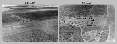
Photograph - RA Svy Project C4 Aerodist Operation, Eastern Arnhem Land, NT, 1967
... It was the same aircraft type and company contracted to Division of National Mapping for Aerodist MRC2 surveys. From July to October 1967 the aircraft was attached to Central Comd Fd Svy Unit (Adelaide - Major Don Ridge) on Project C4 eastern-Arnhem Land NT, where 317 Aerodist lines measuring 17,300 line miles were successfully completed. ...It was the same aircraft type and company contracted to Division of National Mapping for Aerodist MRC2 surveys. From July to October 1967 the aircraft was attached to Central Comd Fd Svy Unit (Adelaide - Major Don Ridge) on Project C4 eastern-Arnhem Land NT, where 317 Aerodist lines measuring 17,300 line miles were successfully completed. ...This is a set of 30 photographs of Royal Australian Survey Corps (RA Svy) personnel from Central Comd Fd Svy Unit (Adelaide) on Aerodist survey operation - Project C4 in Eastern Arnhem Land, Northern Territory in 1967. Photos of personnel were taken either at the operations base at Numbulwar or the main base at Gove (Nhulunbuy). RA Svy conducted nineteen Aerodist operations for 12 years from 1964 to 1975. Aerodist MRC2 was a tellurometer-based system adapted for aircraft to accurately measure distances between non-intervisible ground survey stations, using the aircraft as an intermediate station. Lower order geodetic results could be achieved by survey network trilateration. The measured distances between stations formed survey networks from which each station’s latitude and longitude was computed. Aerodist MRC2 was RA Svy’s major horizontal control survey tool for mainly medium scale topographic mapping (scale 1:100,000 Class A being spatially accurate to within 50 metres) in PNG, northern NT, north-west WA, Kalimantan Barat (West) Indonesia, Sumatra Indonesia, Gulf of Carpentaria and Cape York, QLD. In 1967, the Aerodist MRC2 Master equipment was installed in the aircraft featured in this set of photos, Executive Air Services’ (Essendon VIC) Grand Aero Commander VH-EXX. It was the same aircraft type and company contracted to Division of National Mapping for Aerodist MRC2 surveys. From July to October 1967 the aircraft was attached to Central Comd Fd Svy Unit (Adelaide - Major Don Ridge) on Project C4 eastern-Arnhem Land NT, where 317 Aerodist lines measuring 17,300 line miles were successfully completed. This was the most productive Aerodist project thus far. The most common helicopter used by RA Svy up to 1972 was the civilian Bell 47G-2 and the Sioux Light Observation Helicopters (LOH), the Australian Army’s equivalent featured in this photo set. These light observation helicopters had a limiting load carrying capacity of up to about 500 pounds. By comparison, one Aerodist team including two people weighed up to 1,500 pounds. Source: Royal Australian Survey Corps – Aerodist Years 1964-1975 by Peter Jensen. Refer to Item 9061.26P for more photos taken during this Aerodist survey operation.This is a set of 30 photographs of Royal Australian Survey Corps (RA Svy) personnel on Aerodist survey operations in Eastern Arnhem Land, Northern Territory in 1967. The photographs are on 35mm negative film and scanned at 96 dpi. They are part of the Army Survey Regiment’s Collection. .1) to .4) - black & white, 20th August 1967, Project C4 Aerodist Operations Base - Numbulwar, NT. .5) - Photo, black & white, 1967. Probable wrecked Indonesian fishing vessel. .6) to .8) - Photo, black & white, 1967. Unidentified survey operations base, L to R: unidentified personnel. .9) - Photo, black & white, 1967. Unidentified survey operations base, unidentified soldier driving a Haflinger 4x4 Light utility vehicle. .10) - Photo, black & white, 1967. Unidentified survey operations base, L to R: unidentified technician. .11) - Unidentified technician reading two survey altimeters to compute corrections to the measured distances for atmospheric refraction and to compute the sea level distances from the slope distances aircraft to the ground stations. .12) - Photo, black & white, 1967. Survey operations base, L to R: unidentified (x3), W01 Pat Wood BEM, unidentified. .13) to .16) - Photo, black & white, 1967. Unidentified personnel operating remote Aerodist MRC2 ground instruments. .17) to .18) - Photo, black & white, 1967. Unknown RA Svy office location. .19) to .20) - Photo, black & white, 1967. Aerodist MRC2 Master equipment. .21) to .22) - Photo, black & white, 1967. Aero Commander VH-EXX probably at Gove, NT, Central Comd Fd Svy Unit (Adelaide) – OC Major Don Ridge. .23) to .25) - Photo, black & white, 1967. Aero Commander VH-EXX probably at Gove, NT. Unidentified personnel. .26) - Photo, black & white, 1967. Aero Commander VH-EXX probably at Gove, NT. Aerodist antenna pods are visible on the aircraft. .27) to .29) - Photo, black & white, 1967. Australian Army Sioux Light Observation Helicopter (LOH) probably at Gove, NT. .30) - Photo, black & white, 1967. Panelled U337 survey station, visible as a white cross on aerial identification photo..1P to .2P – date and location on edge of film negative. .5P to .28P – no annotations .29P - annotated in white ‘RW-JEP Gove NT’ .30P - annotated in white ‘U337 Spool No1 Jun67’royal australian survey corps, rasvy, army survey regiment, army svy regt, fortuna, asr, aerodist, surveying, central comd fd svy unit -
 Eltham District Historical Society Inc
Document - Folder, Survey Maps and Technical Drawings
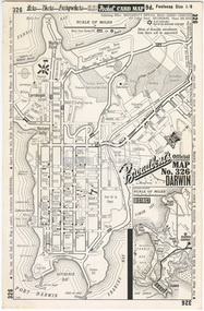
... World Aeronautical Chart: Darwin (3109), ICAO 1: 1,000,000, Division of National Mapping, Department of National Development, Canberra, A.C.T., Nov. 1961 21. ...World Aeronautical Chart: Darwin (3109), ICAO 1: 1,000,000, Division of National Mapping, Department of National Development, Canberra, A.C.T., Nov. 1961 21. ...alan gardiner collection, maps -
 Bendigo Military Museum
Photograph - RA Svy Project C4 Aerodist Operation, Eastern & Western Arnhem Land, NT, 1967, 1968
... It was the same aircraft type and company contracted to Division of National Mapping for Aerodist MRC2 surveys. From July to October 1967 the aircraft was attached to Central Comd Fd Svy Unit (Adelaide - Major Don Ridge) on Project C4 eastern-Arnhem Land NT, where 317 Aerodist lines measuring 17,300 line miles were successfully completed. ...It was the same aircraft type and company contracted to Division of National Mapping for Aerodist MRC2 surveys. From July to October 1967 the aircraft was attached to Central Comd Fd Svy Unit (Adelaide - Major Don Ridge) on Project C4 eastern-Arnhem Land NT, where 317 Aerodist lines measuring 17,300 line miles were successfully completed. ...This is a set of 26 photographs of Royal Australian Survey Corps (RA Svy) personnel from Central Comd Fd Svy Unit (Adelaide) on Aerodist survey operation - Project C4 in Eastern Arnhem Land, Northern Territory in 1967 (photos .4P to .26P) and in Western Arnhem Land, Northern Territory in 1968 (photos .1P to .3P). Photos of personnel were taken either at the operations base at Numbulwar or the main base at Gove (Nhulunbuy). RA Svy conducted nineteen Aerodist operations for 12 years from 1964 to 1975. Aerodist MRC2 was a tellurometer-based system adapted for aircraft to accurately measure distances between non-intervisible ground survey stations, using the aircraft as an intermediate station. Lower order geodetic results could be achieved by survey network trilateration. The measured distances between stations formed survey networks from which each station’s latitude and longitude was computed. Aerodist MRC2 was RA Svy’s major horizontal control survey tool for mainly medium scale topographic mapping (scale 1:100,000 Class A being spatially accurate to within 50 metres) in PNG, northern NT, north-west WA, Kalimantan Barat (West) Indonesia, Sumatra Indonesia, Gulf of Carpentaria and Cape York, QLD. In 1967, the Aerodist MRC2 Master equipment was installed in the aircraft featured in this set of photos, Executive Air Services’ (Essendon VIC) Grand Aero Commander VH-EXX. It was the same aircraft type and company contracted to Division of National Mapping for Aerodist MRC2 surveys. From July to October 1967 the aircraft was attached to Central Comd Fd Svy Unit (Adelaide - Major Don Ridge) on Project C4 eastern-Arnhem Land NT, where 317 Aerodist lines measuring 17,300 line miles were successfully completed. This was the most productive Aerodist project thus far. The most common helicopter used by RA Svy up to 1972 was the civilian Bell 47G-2 and the Sioux Light Observation Helicopters (LOH), the Australian Army’s equivalent featured in this photo set. These light observation helicopters had a limiting load carrying capacity of up to about 500 pounds. By comparison, one Aerodist team including two people weighed up to 1,500 pounds. In 1968, after completion of the Kimberley Aerodist Operation project, the Aerodist system in VH-EXX was immediately deployed to western-Arnhem Land NT for Central Comd Fd Svy Unit (Adelaide - Major Don Ridge) to complete the mapping control across northern NT from mid-July to October. The Aerodist MRC2 Remote antenna seen in Photos .24P to .26P is mounted on a 20 foot pole tower. The antenna direction was controlled by wires/ropes to the two arms under the dish at right angles. The antenna elevation could be changed to the vertical for aircraft height checks as seen in photo .25P. Source: Royal Australian Survey Corps – Aerodist Years 1964-1975 by Peter Jensen. Refer to Item 6449.30P for more photos taken during these Aerodist survey operations.This is a set of 26 photographs of Royal Australian Survey Corps (RA Svy) personnel on Aerodist survey operations in Eastern Arnhem Land, Northern Territory in 1967 and Western Arnhem Land, Northern Territory in 1968. The photographs are on 35mm negative film and scanned at 96 dpi. They are part of the Army Survey Regiment’s Collection. .1) to .2) – Photo, black & white, 1968, unidentified soldier with an opened can of food, possibly bully beef. .3) – Photo, black & white, 15 Aug 1968, aerial view of terrain taken from a helicopter in vicinity of MILINGIMBI SIERRA. .4) – Photo, black & white, 1967, aerial view of an island taken from a helicopter. .5) & .6) – Photo, black & white, 1967, unidentified soldier driving a Haflinger 4x4 Light utility vehicle with trailer. .7) – Photo, black & white, 1967, unidentified surveyors taking vertical measurements with a leveling instrument and staff. .8) – Photo, black & white, 1967, Australian Army Sioux Light Observation Helicopter (LOH) with float removed. .9) to .11) – Photo, black & white, 1967, Australian Army Sioux Light Observation Helicopter (LOH) with floats. .12) – Photo, black & white, 1967, civilian Bell 47G-2 helicopter (Australian Army Sioux LOH equivalent) refuelled. .13) – Photo, black & white, 1967, survey station on coastline surrounded by white plastic aerial photographic identification panels lined with rocks. .14) & .15) – Photo, black & white, 1967, soldier (possibly a signaller from RA Sigs) operating a radio. .16) – Photo, black & white, 1967, Central Comd Fd Svy Unit Operations Section tent, Main Base Gove (Nhulunbuy) L to R: SPR Harry Dunn, WO1 Pat Wood BEM. .17) – Photo, black & white, 1967, Central Comd Fd Svy Unit Operations Section tent, Main Base Gove (Nhulunbuy) L to R: unidentified, WO1 Pat Wood BEM. .18) – Photo, black & white, 1967, Central Comd Fd Svy Unit Operations Section, Main Base Gove (Nhulunbuy), unidentified Australian Army Catering Corps cook preparing meals. .19) – Photo, black & white, 1967, Central Comd Fd Svy Unit Operations Section, Main Base Gove (Nhulunbuy) mess tent in readiness for meals. .20) – Photo, black & white, 1967, Bank of batteries in transit boxes undergoing recharging using generators. .21) – Photo, black & white, 1967, A topographic survey identification plaque set in a concrete block being weighed using a set of scales hanging from slaughtering gallows. .22) – Photo, black & white, 1967, CPL (Geoff or Gary) Larkin operating the remote Aerodist MRC2 ground instrument at Veronica Island, located north of Nhulunbuy. .23) – Photo, black & white, 1967, L to R: CPL (Geoff or Gary) Larkin with unidentified surveyor operate the remote Aerodist MRC2 ground instrument at Venica Island, located north of Nhulunbuy. .24) & .25 – Photo, black & white, 1967, The Aerodist MRC2 Remote antenna. .26) – Photo, black & white, 1967, The Aerodist MRC2 Remote antenna.The following photos are annotated in black ink on edge of film negative: .3P – ’15 Aug ’68, 2000’, 1-C18 ’68 MILINGIMBI SIERRA’ .4P – ’U462’ .8P – ‘1-C3/67 Float Removed’ .13P – ‘U477 10-C3/67 .20P - ‘2-C3/67 Bank of Chargers’ .21P - ‘3-C3/67 Gallows & Scales’ .22P - ‘0462 VERONICA ISLAND NT, CPL Larkin’ .23P - ‘0462 VERONICA ISLAND NT’ .24P - ‘4-C3/67 20’ Aerodist Tower’ .25P - ‘5-C3/67 20’ Aerodist Tower’ .26P - ‘6-C3/67 20’ Aerodist Tower’royal australian survey corps, rasvy, army survey regiment, army svy regt, fortuna, asr, aerodist, surveying, central comd fd svy unit -
 Bendigo Military Museum
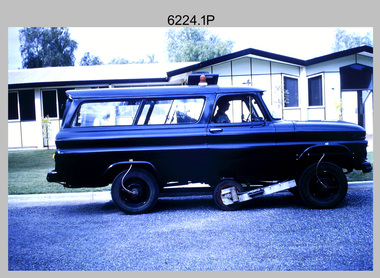
Photograph - Johnson Ground Elevation Meter (JGEM) Survey Vehicle - Army Survey Regiment, Fortuna, Bendigo, c1960s
... A limited number of Ground Elevation Meter (GEM) station wagon type vehicles were manufactured by General Motors Corporation (GMC) in the USA for the United States Geological Survey, Canada’s mapping agencies, RA Svy and National Mapping (Natmap). The GEM was a four-wheel drive, four-wheel steer vehicle. ...A limited number of Ground Elevation Meter (GEM) station wagon type vehicles were manufactured by General Motors Corporation (GMC) in the USA for the United States Geological Survey, Canada’s mapping agencies, RA Svy and National Mapping (Natmap). The GEM was a four-wheel drive, four-wheel steer vehicle. ...This is a set of 16 photograph of the Royal Australian Survey Corps’ Johnson Ground Elevation Meter (JGEM) Survey Vehicle taken at the Army Survey Regiment, Fortuna, Bendigo. The JGEM vehicle was extensively used by RA Svy within Australia from the late 1960s. A limited number of Ground Elevation Meter (GEM) station wagon type vehicles were manufactured by General Motors Corporation (GMC) in the USA for the United States Geological Survey, Canada’s mapping agencies, RA Svy and National Mapping (Natmap). The GEM was a four-wheel drive, four-wheel steer vehicle. Four-wheel steering was necessary to avoid systematic errors caused by non-tracking of front and rear wheels on conventionally steered vehicles. The manufacturer substituted the rear axle with a front axle and connected them to form the four-wheel steering mechanism. The two Australian GEM vehicles, referred to as Johnson GEMs (JGEMs) were converted into right-hand drive. After delivery in 1964, acceptance Natmap and RA Svy testing and operator training was undertaken at the Army's School of Military Survey located at Balcombe, Victoria. A small fifth wheel was mounted on a cantilever arm suspension midway between the front and rear wheels on the right side of the vehicle. It was lowered to and raised from its operating position by use of a constant pressure air cylinder. A telescopic bar, suspended between the front and rear axles, provided the reference datum for the angle measurement. The wheel provided the velocity or distance signal through a pulse generator system. A sensitive pendulum mounted on this bar provided the angle measurement for each minute distance traversed. The JGEM contained electromechanical instruments used to determine relative elevations, by trigonometric principles, along a traversed path. These relative elevations were obtained through apparatus which measures the instantaneous angle of inclination of the road and the instantaneous velocity of the meter along such a path. Road routes over which the JGEM operated were planned so that each started and ended as near as practicable to an existing point of known elevation (formally referred to as a level traverse bench mark). The difference in height from the bench mark and the road surface alongside the JGEM’s fifth wheel was measured with a level and staff. Along each route, mapping control photo reference points where new elevation values were required were identified on aerial photographs. Under favourable conditions it was possible to survey as much as 160km in an ordinary working day. The first of RA Svy’s JGEM operations was undertaken in 1:250,000 scale map areas of Queensland. CPL John Hook was the JGEM’s main operator in the early 1970s undertaking operations covering 1:250,000 scale map blocks over northern Victoria and central NSW, each requiring 36 points (9 runs of photography and 4 points across. SPR Lyn Thompson and SPR Bob McDonagh teamed with CPL Hook on some of these JGEM operations. When RA Svy was integrated into the Royal Australian Engineers in 1996, the JGEM vehicle with the Survey Corps collection was donated to its museum. It is believed to be the last of the original manufactured fleet in existence. The JGEM has undergone extensive refurbishment to achieve roadworthiness and is currently housed at The Australian Army Museum of Military Engineering, Hoslworthy Barracks, NSW. It can be viewed by making an appointment with the museum’s curator.This is a set of 16 photograph of the Royal Australian Survey Corps’ Johnson Ground Elevation Meter (JGEM) Survey Vehicle taken at the Army Survey Regiment, Fortuna, Bendigo. The photographs were on 35mm slide film and were scanned at 96 dpi. They are part of the Army Survey Regiment’s Collection. .1) - Photo, colour, c1960s, Johnson Ground Elevation Meter (JGEM) Survey Vehicle .2) - Photo, colour, c1960s, JGEM instrumentation, on-board computer. .3) - Photo, colour, c1960s, JGEM instrumentation. .4) - Photo, colour, c1960s, JGEM instrumentation, on-board computer. .5) - Photo, colour, c1960s, JGEM tyre pressure controller .6) - Photo, colour, c1960s, JGEM rear doors, SGT Geoff Briggs. .7) - Photo, colour, c1960s, JGEM 5th wheel distance/angle measurement device in lowered position, SGT Geoff Briggs. .8) - Photo, colour, c1960s, JGEM 5th wheel distance/angle measurement device in lowered position. .9) & .10) - Photo, colour, c1960s, JGEM tyre pressure system, SGT Geoff Briggs. .11) - Photo, colour, c1960s, JGEM tyre pressure system. SGT Geoff Briggs. .12) - Photo, colour, c1960s, JGEM levelling scope, levelling staff, unidentified technicians. .13) & .14) - Photo, colour, c1960s, JGEM levelling scope, unidentified technician. .15) & .16) - Photo, colour, c1960s, probably survey operation adjusted height plotted on block base sheet. .1P to .16P - Some of the equipment is annotated on the frame of the 35mm slides.royal australian survey corps, rasvy, army survey regiment, army svy regt, fortuna, asr, surveying -
 Kiewa Valley Historical Society
Maps - Bogong x2, Tawonga, Omeo, Dargo, Victoria and others, 1. Bogong Alpine Area; 2. Bogong 8324; 3. Tawonga Topographical; 4. Omeo 8433; 5. Dargo 8323; 6. Victoria State
... Bogong Alpine Area (outdoor Leisure Map. survey & Mapping Victoria, Government of Victoria, Edition 2, reprinted 1991 with an image of Mt. Feathertop on the front. Information for tourist in the Alpine National Park: Bogong Area. ...Bogong Alpine Area (outdoor Leisure Map. survey & Mapping Victoria, Government of Victoria, Edition 2, reprinted 1991 with an image of Mt. Feathertop on the front. Information for tourist in the Alpine National Park: Bogong Area. ...1. Bogong Alpine Area (outdoor Leisure Map. survey & Mapping Victoria, Government of Victoria, Edition 2, reprinted 1991 with an image of Mt. Feathertop on the front. Information for tourist in the Alpine National Park: Bogong Area. Including: recreational activities, history, weather and vegetation and a list of walks together with locality maps and photographs. The front cover has an image of Mt Feathertop against a blue sky with yellow writing 'Bogong Alpine Area', there is a yellow triangular block on the right hand top corner with black writing 'Outdoor Leisure Map. On the bottom edge is a block of yellow with black writing 'Survey & Mapping Victoria' and a light green map of Victoria with 'VICMSP' printed in white. 2. 8324 Bogong Victoria, Edition 1, Commonwealth of Australia 1981. A topographical Map: 1:100,000 scale (1 cm to 1 KM). Map has a red cover with white writing together with a white block and black writing and a map insert. 3. Tawonga Topographical Map - Forests Commission Victoria, / revised 5/9/77, DEG No. 68-G/399. A Tawonga 803 folded map in a beige colour with the back blank. 4. Omeo 8433 Victoria, Edition 1, Department of Natural Resources. The map has a red and white cover with black writing and a simple map of Australia at the bottom. 5. 8323 Dargo, Edition 1, Commonwealth of Australia. A red and white cover with a map insert. 6. Victoria State Map, Hema Maps, 2002. Hema Maps, State Map, colourful cover with a map of Australia and four tourism photographs. Scale 1: 850,000 An inscription handwritten in blue pen "Trappers Gap to Mitta Mitta 1" to 1 mile". There are some pen markings and notations of tracks.maps, bogong, omeo, tawonga, dargo, victoria, bogong alpine area -
 Orbost & District Historical Society
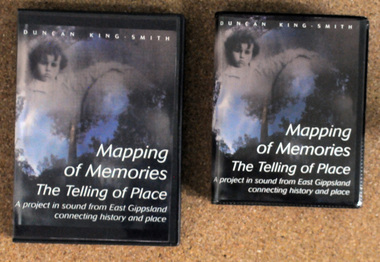
discs and tapes, Mapping of Memories The Telling of Place, 1991-1993
... These stories are from the Orbost district, Snowy River flats, Conran, Bete Bolong, Marlo, Bonang, Goongerah, Combienbar, Club Terrace,Cann Valley, Cabanandra, Bendoc, Deddickand McKillop's Bridge' Mapping of Memories was first broadcast as four programs on A.B.C. Radio National in 1993....Orbost & District Historical Society Ruskin Street Orbost gippsland These stories are from the Orbost district, Snowy River flats, Conran, Bete Bolong, Marlo, Bonang, Goongerah, Combienbar, Club Terrace,Cann Valley, Cabanandra, Bendoc, Deddickand McKillop's Bridge' Mapping of Memories was first broadcast as four programs on A.B.C. Radio National in 1993. ...These stories are from the Orbost district, Snowy River flats, Conran, Bete Bolong, Marlo, Bonang, Goongerah, Combienbar, Club Terrace,Cann Valley, Cabanandra, Bendoc, Deddickand McKillop's Bridge' Mapping of Memories was first broadcast as four programs on A.B.C. Radio National in 1993.This item is a record of the lives and history associated with East Gippsland. It is a useful reference tool.Two copies of a D.V.D. titled, "Mapping of Memories The Telling of Place". There are also two tapes - 4 sides. The D.V.D.'s are in black plastic cases with 2 discs in each. The front cover has a colored photo of a child next to a giant pumpkin.memories-orbost-district mapping-of-memories -
 Bendigo Historical Society Inc.
Newspaper - LONG GULLY HISTORY GROUP COLLECTION: SHOWCASING OUR PAST
... National Trust Chambers... Information Centre... Commonwealth Bank... City of Greater Bendigo... Museum Victoria... Andrew Paul... Sir John Quick... Jenny Whitelaw... Peter Tangey... Fortuna... George Lansell... Army's Topographical Mapping...History House 11 Mackenzie Street Bendigo goldfields BENDIGO History long gully history group The Long Gully History Group - Showcasing Our Past Bendigo Advertiser 20/2/1999 John Gascoigne Golden Dragon Museum Bendigo Pottery RSL Memorial Hall Central Deborah Gold Mine Greater City's Heritage and Historical Societies Kathryn Mackenzie Bendigo Tourism Inc Heidi Teague German Heritage Society Eureka Museum Joan Bolton David Bolton Bolton Bros Joan O'Shea Lister House Northern District School of Nursing Graduates Association Department of Human Services Public Records Office Bendigo Hospital Cliff Binks School of Mines Bendigo Regional Institute of TAFE Frank Cusack Bendigo Junior Technical School National Trust Chambers Information Centre Commonwealth Bank City of Greater Bendigo Museum Victoria Andrew Paul Sir John Quick Jenny Whitelaw Peter Tangey Fortuna George Lansell Army's Topographical Mapping Unit A Steele Weekender article from the Bendigo Advertiser 20/2/1999 mentioning the push for a museum for Bendigo by John Gascoigne. ...Weekender article from the Bendigo Advertiser 20/2/1999 mentioning the push for a museum for Bendigo by John Gascoigne. People including Kathryn Mackenzie, , Heidi Teague, Joan Bolton, David Bolton, Joan O'Shea, Cliff Binks, Frank Cusack, Ted Barkmeyer, Andrew Paul and Peter Tangey were interviewed. There is a colour photo of Joan Bolton with an old printing machine and a black and white photo looking up Mitchell Street. On the back of this page there is another item relating to preserving Bendigo's Past, (from Weekender 17). A black and white photo at the top of the page shows Bendigo in the 1860s looking up Mitchell Street, (Photo courtesy of Frank Cusack).bendigo, history, long gully history group, the long gully history group - showcasing our past, bendigo advertiser 20/2/1999, john gascoigne, golden dragon museum, bendigo pottery, rsl memorial hall, central deborah gold mine, greater city's heritage and historical societies, kathryn mackenzie, bendigo tourism inc, heidi teague, german heritage society, eureka museum, joan bolton, david bolton, bolton bros, joan o'shea, lister house, northern district school of nursing graduates association, department of human services, public records office, bendigo hospital, cliff binks, school of mines, bendigo regional institute of tafe, frank cusack, bendigo junior technical school, national trust chambers, information centre, commonwealth bank, city of greater bendigo, museum victoria, andrew paul, sir john quick, jenny whitelaw, peter tangey, fortuna, george lansell, army's topographical mapping unit, a steele -
 Bendigo Historical Society Inc.
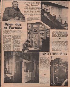
Newspaper - LYDIA CHANCELLOR COLLECTION: FORTUNA
... mapping... Bendigo... Fortuna employees... printing... army... Colonel L. B. Sprenger... National...History House 11 Mackenzie Street Bendigo goldfields BENDIGO Buildings fortuna villa Lydia Chancellor Collection collection Fortuna homestead house houses building buildings AHQ Survey Regiment Royal Australian Survey Corps mapping Bendigo Fortuna employees printing army Colonel L. B. Sprenger National Trust George Lansell Lansell family heritage place house. houses A two page article from the Bendigo 'Advertiser' on 'Open Day at Fortuna.' ...A two page article from the Bendigo 'Advertiser' on 'Open Day at Fortuna.' Apart from information about Fortuna it includes photographs of some of the rooms at Fortuna including the Royal Australian Survey Corp's AHQ Survey Regiment mapping room. It also has other photographs within the house and in the grounds. 7/4/1970.bendigo, buildings, fortuna villa, lydia chancellor collection, collection, fortuna, homestead, house, houses, building, buildings, ahq survey regiment, royal australian survey corps, mapping, bendigo, fortuna employees, printing, army, colonel l. b. sprenger, national trust, george lansell, lansell family, heritage, place, house. houses -
 Federation University Historical Collection
Book, Sivaprasad Das Gupta, Abstract of Papers: 21st International Geographical Congress, 1968, 1968
... mapping migration population urban planning cartography Soft covered white and orange book. Abstract of Papers: 21st International Geographical Congress, 1968 Book Robert H.T. Smith Sivaprasad Das Gupta Teresa Romanowska-Lakshmanan National ...Soft covered white and orange book.non-fictionrobert h.t. smith, geography, geomorphology, climatology, mapping, migration, population, urban planning, cartography -
 Merri-bek City Council
Lithograph, Megan Cope, Black Napoleon (Eulope), 2019
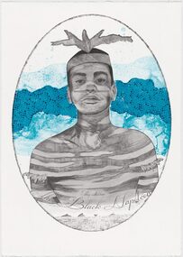
... mapping practices. Black Napoleon (Eulope) is part of a series of lithographs that highlights what Cope sees as ‘just one of the many stories of powerful and clever people defying Empire’ at the turn of the 19th century in Australia. The Black Napoleon series was produced as part of the Australian Print Workshop’s French Connections project. The project aimed to produce new work responding to the National...mapping practices. Black Napoleon (Eulope) is part of a series of lithographs that highlights what Cope sees as ‘just one of the many stories of powerful and clever people defying Empire’ at the turn of the 19th century in Australia. The Black Napoleon series was produced as part of the Australian Print Workshop’s French Connections project. The project aimed to produce new work responding to the National ...Working across installation, video and painting, Quandamooka artist Megan Cope investigates issues relating to colonial histories, the environment and mapping practices. Black Napoleon (Eulope) is part of a series of lithographs that highlights what Cope sees as ‘just one of the many stories of powerful and clever people defying Empire’ at the turn of the 19th century in Australia. The Black Napoleon series was produced as part of the Australian Print Workshop’s French Connections project. The project aimed to produce new work responding to the National Archive in Paris, with a focus on cultural materials relating to early exploration of Australia and the Pacific. It was important to Cope that she did not simply repeat the material of the archive, which was collected and conserved within a colonial framework. Instead, Cope’s work addresses Eulope’s sovereignty and role in resisting invasion. Eulope was a Quandamooka man named after Napoleon Buonaparte because of his leadership in battles against British forces, which invaded Stradbroke Island in the early 1800s. -
 Melbourne Tram Museum
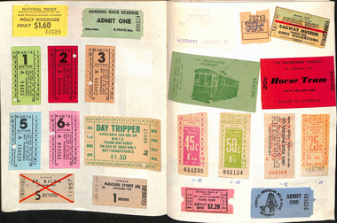
Ephemera - Exercise Book, Keith Stodden, "Tickets 2", 1950's to 1980's
... Exercise or Mapping book - Australian Mapping book, decorative cover with mathematical tables on the rear, plain paper, 48 pages holding tickets collected by Keith Stodden. Titled "Tickets 2". Tickets have been positioned using stamp hinges. Pages 1 - Sydney 2 - 5 - mixed VR Bus, MMTB, railway tours, National...Melbourne Tram Museum 8 Wallen Road Hawthorn melbourne Trams tramways Tickets The Met MMTB Adelaide Sec TMSV Sydney Buses Exercise or Mapping book - Australian Mapping book, decorative cover with mathematical tables on the rear, plain paper, 48 pages holding tickets collected by Keith Stodden. Titled "Tickets 2". Tickets have been positioned using stamp hinges. Pages 1 - Sydney 2 - 5 - mixed VR Bus, MMTB, railway tours, National ...Exercise or Mapping book - Australian Mapping book, decorative cover with mathematical tables on the rear, plain paper, 48 pages holding tickets collected by Keith Stodden. Titled "Tickets 2". Tickets have been positioned using stamp hinges. Pages 1 - Sydney 2 - 5 - mixed VR Bus, MMTB, railway tours, National Trust, and other admission tickets 6 - 8 - Brisbane 9 - BTMS, TAA 10 - TMSV, Sydney 11 - MMTB 12 - Sandhurst Town, National Trust, mixed admission 13 - Sydney 14 - MMTB Bus 15 - Adelaide 16 - 19 - Brisbane 20 - 21- Melbourne Rail, 22 - Melbourne Pageant 23 - 24 - Melbourne Rail and Tram - Travel cards 25 - 26 - Auckland, MOTAT 27 - 28 - Travelcards, Ballarat, Bendigo, Perth, MMTB Swimming ticket 29 - Melbourne rail 30 - Ansett bus, rail and MTT Perth 31 - 32 - Rail travel cards 33 - CRB Westgate bridge toll, Neighbourhood tickets 34 - ARHS ACT, Westgate bridge toll vouchers, 35 - 37 - MMTB, Rail travel cards, ACT bus 38 - Muni, and Travelcard 39 - 40 - Rail, 41 - 42 - travel cards, ARHS ACT 43 - 44 - Travelcards, Santa tram Bendigo 45 - blank 46 - VicRail country ticket, Ansett boarding pass 47 - Levers coachlines.trams, tramways, tickets, the met, mmtb, adelaide, sec, tmsv, sydney, buses -
 National Vietnam Veterans Museum (NVVM)
Manual, Australian Army, Australian Army: Supplies And POL Instructions (All Arms): Amendment No.:1
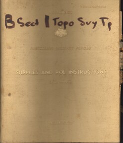
... National Vietnam Veterans Museum (NVVM) 25 Veterans Drive Newhaven phillip-island-and-the-bass-coast Australia - Armed Forces - Service manuals Topo Svy Tp - B Sect Mapping A cream coloured cover that has lots of what appears to be grime with gold writing on the front. ...A cream coloured cover that has lots of what appears to be grime with gold writing on the front. At the top right hand reads in gold 7310-66-027-2300. Hand written in black texta reads B Sect / Topo Svy Tpaustralia - armed forces - service manuals, topo svy tp - b sect, mapping -
 Bendigo Historical Society Inc.
Newspaper - Fortuna Article - "DIGO's new home opens", Nov 13 2008
... national interests. The facility ensures DIGO remains a world-class organization in geospatial information and services. Bendigo has been important to Australia's defence since 1942, previously hosting Defence mapping at the Fortuna site. ...national interests. The facility ensures DIGO remains a world-class organization in geospatial information and services. Bendigo has been important to Australia's defence since 1942, previously hosting Defence mapping at the Fortuna site. ...The article highlights the opening of the $52 million Defence Imagery and Geospatial Organisation (DIGO) facility in Junortoun, Bendigo, emphasizing its strategic and economic significance The new DIGO centre is the sole provider of geospatial intelligence for Australia's defence and national interests. The facility ensures DIGO remains a world-class organization in geospatial information and services. Bendigo has been important to Australia's defence since 1942, previously hosting Defence mapping at the Fortuna site. Defence spends about $130 million annually in Bendigo on personnel, equipment, services, and facilities. The new DIGO facility is expected to promote local employment and economic growth. Defence Minister Joel Fitzgibbon visited Thales Australia, which designs and produces the Bushmaster Protected Mobility Vehicle.Defence recently ordered 293 more Bushmasters, totaling 737 vehicles.Fortuna Article - "DIGO's new home opens" - The Bendigo Miner Thursday Nov 13 2008 Picutres Julian Prowd This item contains the following: 11217.20a Colour Photo of Joel Fitzgibbon 11217.20b Part of page 5 - Article "DIGO's new home opens" non-fictionbendigo, fortuna, george lansell, digo, geospatial intelligence -
Bendigo Historical Society Inc.
Document - National Trust Collection: Fortuna Bendigo, 20/10/2008
... The property fell into disrepair before being leased by the Army in 1942 for wartime mapping and later purchased by the Commonwealth Government.It became the headquarters for the Army Survey Regiment, with parts of the building repurposed for administrative and mapping functions until the 1980s. history National Trust Bendigo Collection bendigo Fortuna George Lansell mining Classification Report and Notes on the history of Fortuna from the National Trust to the Bendigo Council 20th October 2008. ...The Fortuna Villa is an expansive Victorian mansion built entirely on the profits of Bendigo's lucrative gold reefs. Established by the wealthy Ballerstedt family in the 1860s, it was purchased and expanded in the 1870s by George Lansell, who was to become one of Australia's wealthiest men. Fortuna villa and gardens were once occupied and cared for by the Australia Army Survey Regiments since 1942 for over thirty years. The tour guide informs us that Fortuna Villa was originally a modest two-story villa, acquired by George Lansell in 1871 along with the 180 Mine for £230,000.Lansell, known as the "Quartz King," made his fortune through deep reef gold mining in Bendigo, particularly with the New Chum Reef and other successful mines. The villa and its grounds expanded significantly as Lansell's wealth grew, incorporating architectural features inspired by his travels. The mansion is built over the New Chum Reef, with its lower floor penetrating the reef, resulting in three floors at the rear and two at the front.Notable features include the Italian water garden, tiered lakes (originally mine settling ponds), elaborate interiors (parquet floors, stained glass, marble baths), and a tunnel used for gold transport. The building underwent several phases of construction, including a reversal of its main entrance and the addition of a cupola stairwell and conservatory. Fortuna Villa hosted many notable guests, including governors and possibly the Prince of Wales.The house was lavishly furnished and decorated, reflecting Lansell's wealth and status. After Lansell's death in 1906, the villa remained in the family until 1934, then was sold and briefly used as a reception house. The property fell into disrepair before being leased by the Army in 1942 for wartime mapping and later purchased by the Commonwealth Government.It became the headquarters for the Army Survey Regiment, with parts of the building repurposed for administrative and mapping functions until the 1980s.Classification Report and Notes on the history of Fortuna from the National Trust to the Bendigo Council 20th October 2008. This item contains the following documents: 3084.46a Tourist brochure for Fortuna; 16 pages - it includes photographs and detailed history of George Lansell's involvement in the property and his mining history. 3084.45b Fortuna Bendigo re Clasification by the National Trust Detailed Letter to the Bendigo Council in 2008 contains an excellent 11 page summary of its history.history, national trust bendigo collection, bendigo, fortuna, george lansell, mining -
 Flagstaff Hill Maritime Museum and Village
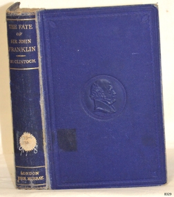
Book - Reference Travel Diary/History, Sir Francis Leopold M'Clintock, The Voyage of The 'Fox'. Fate of Sir John Franklin, 1881
... During these, he revolutionized Arctic travel by perfecting the use of human-hauled and dog-driven sledges, mapping thousands of miles of unknown Arctic coastline. His successful retrieval of the Victory Point record made him a national hero. ...During these, he revolutionized Arctic travel by perfecting the use of human-hauled and dog-driven sledges, mapping thousands of miles of unknown Arctic coastline. His successful retrieval of the Victory Point record made him a national hero. ...This classic 1859 maritime narrative with the subject copy being the 1881 fifth edition details one of the most significant moments in Arctic exploration. It follows the definitive discovery of what happened to Sir John Franklin’s lost expedition. The Voyage of the 'Fox' is a first-hand travel diary and official report written by Captain Francis Leopold McClintock.The Voyage of The 'Fox'. The Fate of Sir John Franklin Author: Sir F Leopold M'Clintock Publisher: John Murray, Albemarle Street, London. Publisher to the Admiralty Date: 1881 Blue embossed hardcover with a blue spine and lettering in gold. The spine has a Library label with an inscription.non-fictionThis classic 1859 maritime narrative with the subject copy being the 1881 fifth edition details one of the most significant moments in Arctic exploration. It follows the definitive discovery of what happened to Sir John Franklin’s lost expedition. The Voyage of the 'Fox' is a first-hand travel diary and official report written by Captain Francis Leopold McClintock.flagstaff hill, warrnambool, shipwrecked coast, flagstaff hill maritime museum, maritime museum, shipwreck coast, flagstaff hill maritime village, great ocean road, book, pattison collection, warrnambool library, warrnambool mechanics’ institute, ralph eric pattison, corangamite regional library service, warrnambool city librarian, mechanics’ institute library, victorian library board, warrnambool books and records, warrnambool children’s library, the voyage of the 'fox'. the fate of sir john franklin, sir f leopold m'clintock, arctic exploration