Showing 24 items matching "new chum railway co."
-
 Bendigo Historical Society Inc.
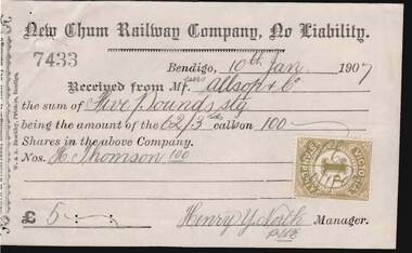
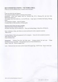
Document - KELLY AND ALLSOP COLLECTION: SHARE CERTIFICATE & RECEIPTS - NEW CHUM RAILWAY CO, 18/12/1905 to 23/04/1907
... KELLY AND ALLSOP COLLECTION: SHARE CERTIFICATE & RECEIPTS - NEW CHUM RAILWAY CO....... New Chum Railway Co....New Chum Railway Company, No Liability, New Chum & Belle Vue Reefs, Golden Square, Bendigo. Certificate represents 100 shares @ 5 Pounds each. Capital raised was 184,450 Pounds from 36,890 shares. Certificate No. 192 issued to H.Thomson of Fryerstown on 18 Dec. 1905. and signed by J.Stanfield, Manager. Two receipts Nos.7433 & 7636 for 5 Pounds & 2 Pounds 10 shillings, respectively as calls on 100 shares owned by H. Thomson and signed by Henry Y.North, Manager. One purchase receipt, dated 23 April 1907. Bought form Michael Kelly 100 New Chum Railway Co...New Chum Railway Co....North H.Thomson J.Stanfield J.Wills New Chum Railway Co. Documents. KELLY & ALLSOP COLLECTION. ...Documents. KELLY & ALLSOP COLLECTION. Share certificate issued by the New Chum Railway Company, No Liability, New Chum & Belle Vue Reefs, Golden Square, Bendigo. Certificate represents 100 shares @ 5 Pounds each. Capital raised was 184,450 Pounds from 36,890 shares. Certificate No. 192 issued to H.Thomson of Fryerstown on 18 Dec. 1905. and signed by J.Stanfield, Manager. Two receipts Nos.7433 & 7636 for 5 Pounds & 2 Pounds 10 shillings, respectively as calls on 100 shares owned by H. Thomson and signed by Henry Y.North, Manager. One purchase receipt, dated 23 April 1907. Bought form Michael Kelly 100 New Chum Railway Co. shares. J.Wills, purchaser.New Chum Railway Co.business, stockbroker, kelly & allsop, kelly & allsop collection, new chum railway co., share certificate, call & purchase receipts, henry y. north, h.thomson, j.stanfield, j.wills -
 Bendigo Historical Society Inc.
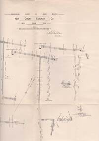
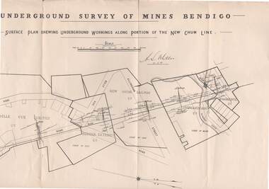
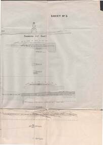
Map - STRUGNELL COLLECTION: UNDERGROUND SURVEY OF MINES, BENDIGO, 25-5-01
... ...new chum railway co....Map, Underground Survey of Mines, Bendigo, New Chum Railway Co, New Chum Line....History House 11 Mackenzie Street Bendigo goldfields MAP Bendigo new chum railway co. A.S.Whitelaw Map, Underground Survey of Mines, Bendigo, New Chum Railway Co, New Chum Line. ...Map, Underground Survey of Mines, Bendigo, New Chum Railway Co, New Chum Line.A.S.Whitelawmap, bendigo, new chum railway co. -
 Bendigo Historical Society Inc.
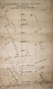
Map - STRUGNELL COLLECTION: UNDERGROUND SURVEY OF MINES, BENDIGO, 29-3-01
... ...new chum railway co....Map, Underground Survey of Mines, New Chum Railway Co., New Chum Line, Transverse Section....History House 11 Mackenzie Street Bendigo goldfields MAP Bendigo new chum railway co. A.S.Whitelaw Map, Underground Survey of Mines, New Chum Railway Co., New Chum Line, Transverse Section. ...Map, Underground Survey of Mines, New Chum Railway Co., New Chum Line, Transverse Section.A.S.Whitelawmap, bendigo, new chum railway co. -
 Bendigo Historical Society Inc.
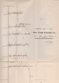
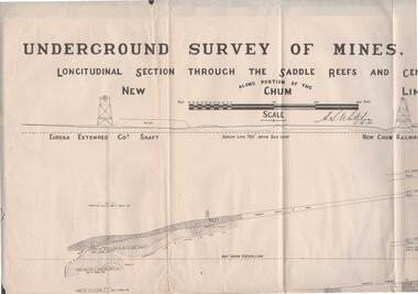
Map - STRUGNELL COLLECTION: NEW CHUM LINE OF REEF, 5/4/01
... Map, Along portion of the New Chum Line, Underground Survey of Mines, Bendigo, Longitudinal Section through the Saddle Reefs and Centre Country. Eureka Extended Co's shaft, New Chum Railway Co's shaft. ...History House 11 Mackenzie Street Bendigo goldfields MAP Bendigo new chum line H.S.Whitelow Map, Along portion of the New Chum Line, Underground Survey of Mines, Bendigo, Longitudinal Section through the Saddle Reefs and Centre Country. Eureka Extended Co's shaft, New Chum Railway ...Map, Along portion of the New Chum Line, Underground Survey of Mines, Bendigo, Longitudinal Section through the Saddle Reefs and Centre Country. Eureka Extended Co's shaft, New Chum Railway Co's shaft. Surveyed under the supervision of H.Herman, B.C.E., F.G.S., Acting Government Geologist.H.S.Whitelowmap, bendigo, new chum line -
 Bendigo Historical Society Inc.
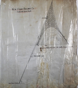
Plan - New Chum Railway Gold Mine
... Written on top of plan: 'New Chum Railway Co, Scale 10ft to an inch'. Annotations include: 'Size of reef and slide' and 'crosscut 32' below 2878' level and 246 south of main crosscut' written on bottom of plan. ...The New Chum Railway Gold Mine was located in near Breen Street, Golden Square, immediately adjacent to the Railway line. Margaret Roberts gold gold mine Bendigo New Chum Railway Gold Mine Plan hand drawn on white paper. Written on top of plan: 'New Chum Railway Co ...The New Chum Railway Gold Mine was located in near Breen Street, Golden Square, immediately adjacent to the Railway line.Plan hand drawn on white paper. Written on top of plan: 'New Chum Railway Co, Scale 10ft to an inch'. Annotations include: 'Size of reef and slide' and 'crosscut 32' below 2878' level and 246 south of main crosscut' written on bottom of plan. Plan forms part of the Margaret Roberts Collection of mining records. margaret roberts, gold, gold mine, bendigo, new chum railway gold mine -
 Bendigo Historical Society Inc.
Document - UNDERGROUND SURVEY OF BENDIGO MINES
... Report on the New Chum Railway Reserve Company and the Shenandoah Company, the New Chum Railway Co being immediately south and the Shenandoah Co immediately north of the railway line. ...Report on the New Chum Railway Reserve Company and the Shenandoah Company, the New Chum Railway Co being immediately south and the Shenandoah Co immediately north of the railway line. ...Two page document, 'Underground survey of Bendigo, report on Constellation Company's Mine on northern extension of the Garden Gully line of reef. Report on the New Chum Railway Reserve Company and the Shenandoah Company, the New Chum Railway Co being immediately south and the Shenandoah Co immediately north of the railway line. Two maps Constellation Co. Mine shaft and New Chum Railway and Shenandoah auriferous reef below 2700 feet.Jems Stirling, geologist and W.H Cundy Underground Surveyor, Department of Minesbendigo, mining, garden gully line of reef mines -
 Bendigo Historical Society Inc.
Map - STRUGNELL COLLECTION: NEW CHUM LINE, 25/5/01
... Map, Surface Plan Showing underground workings along portion of the New Chum Line.South Belle Vue United, Eureka Extended, New Chum Railway, Shenandoah Co. ...History House 11 Mackenzie Street Bendigo goldfields MAP Bendigo new chum line A.S.Whitelaw Map, Surface Plan Showing underground workings along portion of the New Chum Line.South Belle Vue United, Eureka Extended, New Chum Railway, Shenandoah Co. ...Map, Surface Plan Showing underground workings along portion of the New Chum Line.South Belle Vue United, Eureka Extended, New Chum Railway, Shenandoah Co. Shamrock Co..A.S.Whitelawmap, bendigo, new chum line -
 Bendigo Historical Society Inc.
Plan - New Chum and Bellevue Railway Reserve
... Transverse plan of New Chum and Bellevue Railway Reserve Co. mines, drawn on off-white paper. ...Margaret Roberts gold gold mine Bendigo New Chum and Bellevue Railway Reserve Transverse plan of New Chum and Bellevue Railway Reserve Co. mines, drawn on off-white paper. ...Transverse plan of New Chum and Bellevue Railway Reserve Co. mines, drawn on off-white paper. Written on top of plan: 'Underground Survey of Mines Sandhurst, New Chum and Railway Reserve Co. Plan forms part of the Margaret Roberts Collection of mining records. margaret roberts, gold, gold mine, bendigo, new chum and bellevue railway reserve -
 Bendigo Historical Society Inc.
Map - STRUGNELL COLLECTION: UNDERGROUND SURVEY OF MINES BENDIGO
... Map, Underground Survey of Mines, Bendigo, New Chum Railway Reef, Shenandoah Co's Shaft, Shamrock Co's Shaft.Young Chum Reef, Thorpe's Reef, Shenandoah Reef, Consolidated Reef, Sheet 3.Survey under the Supervision of H.Herman. ...History House 11 Mackenzie Street Bendigo goldfields MAP Bendigo shamrock & shenandoah co's Map, Underground Survey of Mines, Bendigo, New Chum Railway Reef, Shenandoah Co's Shaft, Shamrock Co's Shaft.Young Chum Reef, Thorpe's Reef, Shenandoah Reef, Consolidated Reef, Sheet 3.Survey under the Supervision of H.Herman. ...Map, Underground Survey of Mines, Bendigo, New Chum Railway Reef, Shenandoah Co's Shaft, Shamrock Co's Shaft.Young Chum Reef, Thorpe's Reef, Shenandoah Reef, Consolidated Reef, Sheet 3.Survey under the Supervision of H.Herman. Drawing shows mine shafts to over 3100 feet deepmap, bendigo, shamrock & shenandoah co's -
 Bendigo Historical Society Inc.
Document - LONG GULLY HISTORY GROUP COLLECTION: THE BENDIGO POST OFFICE
... New Chum and Victoria Mine and Battery... New Chum Railway... Koch's Pioneer... South New Moon... Catherine Reef United... New Moon... The Virginia... South Bell Vue... Central Nell Gwynne... North Nell Gwynne... Miner's Phthisis... Hercules Engine House... Ironbark... New Chum Syncline... Hercules Energetic... Roberts & Sons... Harkness & Co...History House 11 Mackenzie Street Bendigo goldfields BENDIGO History long gully history group The Long Gully History Group - The Bendigo Post Office L C Bennetts Mt Alexander Post Office Porcupine Inn Cenotaph Pike or Pyke Baby Health Centre Sandhurst Post Office Government Survey Office Queen Elizabeth Oval Sandhurst Trustees Company Mr H B Briston Savings Bank Telegraph Office The Sub-Treasury Sir Henry Brougham Lock KCB Sir John Nimmo MLA Prince of Wales group of mines The New Prince of Wales Eaglehawk Golf Links New Prince of Wales No 2 The Whip and Jersey Mines Department Lansell's Big 180 New Chum and Victoria Mine and Battery New Chum Railway Koch's Pioneer South New Moon Catherine Reef United New Moon The Virginia South Bell Vue Central Nell Gwynne North Nell Gwynne Miner's Phthisis Hercules Engine House Ironbark New Chum Syncline Hercules Energetic Roberts & Sons Harkness & Co Horwoods Great Southern Ulster Carlisle Lansells Big 180 Victoria Quartz New St Mungo Duchess Tribute South Devonshire Hopewell Mine Saxby Mine McNair & Co Shamrock Mr King Burke and Wills Expedition Sandhurst Hotel Courthouse Hiberian The Freemasons The Courthouse The Commercial Law Courts The Hamburg The European The Prince Bismark The Lord Kitchener The Bendigo The Rosalind Park The Showgrounds Atheneum Club Olivers Bridge Hotel Bourkes The Globe The Hibernia Albert Albion Abbotts Australian Belvidere Beehive British Queen Black Eagle British and American Brian Boru Bakers Arms Butchers Arms Brick Layers Arms Bull and Mouth Cresent Clarence Back Creek Bridge Cape Clear Crooked Billet Cambridgeshire Arms Camp Coach and Horses Cricketers Arms Diggers Rest Ellesmere Five Lions Franklyn Golden Square Golden Gate Golden Gully Golden Age Golden Vine Gumtree Glasgow Reef Great Britain Haymarket Daniel O'Connell Half Way House Fleece Inn Ironbark Johnsons Reef Lancashire Live and Let Live Manchester Arms Gold Mines Metropolitan Crown National New Chum Honeysuckle Street Pavilion Napier Arms Quartz Miners Arms Retreat Inn Rainbow Rose of Australia Lake View Robin Hood Fountain Southern Cross Bath Berlin Spring Gully Star Sir Charles Hotham Silvermines Royal Oak Suburban Town Hall Temperance Ship Inn View Point View Bend Victoria Exchange American Arcade Belfast All Nations Union United Kingdom Union Jack Westend Washington Waterloo Wellington Whitehorse Wheat Sheaf Yorkshire Niagra Noahs Ark Article titled The Bendigo Post Office, compiled by L C Bennetts. ...Article titled The Bendigo Post Office, compiled by L C Bennetts. Mentioned is the history of the Bendigo Post Office and postmarks, some information on mining, Bendigo foundries, Underground connections of mines, expenses and shaft sinking costs. Also mentioned is Bendigo and Eaglehawk - 60 years ago and the role the pubs played in daily living. They were where theatres, concerts and dances were held, and the meeting rooms for clubs and lodges, even church benefits. Listed is a number of Bendigo hotels. Some even had a few names. Names of the pubs are: The Freemasons, The Courthouse, The Commercial Law Courts, The Hamburg, The European, The Prince Bismark, The Lord Kitchener, The Bendigo, The Rosalind Park, The Showgrounds, Atheneum Club, Olivers, Bridge Hotel, Bourkes, The Globe, The Hibernia, Albert, Albion, Abbotts, Australian, Belvidere, Beehive, British Queen, Black Eagle, British and American, Brian Boru, Bakers Arms, Butchers Arms, Brick Layers Arms, Bull and Mouth, Cresent, Clarence, Back Creek Bridge, Cape Clear, Crooked Billet, Cambridgeshire Arms, Camp, Coach and Horses, Cricketers Arms, Diggers Rest, Ellesmere, Five Lions, Franklyn, Golden Square, Golden Gate, Golden Gully, Golden Age, Golden Vine, Gumtree, Glasgow Reef, Great Britain, Haymarket, Daniel O'Connell, Half Way House, Fleece Inn, Ironbark, Johnsons Reef, Lancashire, Live and Let Live, Manchester Arms, Gold Mines, Metropolitan, Crown, National, New Chum, Honeysuckle Street, Pavilion, Napier Arms, Quartz Miners Arms, Retreat Inn, Rainbow, Rose of Australia, Lake View, Robin Hood, Fountain, Southern Cross, Bath, Berlin, Spring Gully, Star, Sir Charles Hotham, Silvermines, Royal Oak, Suburban, Town Hall, Temperance, Ship Inn, View Point, View Bend, Victoria, Exchange, American, Arcade, Belfast, All Nations, Union, United Kingdom, Union Jack, Westend, Washington, Waterloo, Wellington, Whitehorse, Wheat Sheaf, Yorkshire, Niagra and Noahs Ark.bendigo, history, long gully history group, the long gully history group - the bendigo post office, l c bennetts, mt alexander post office, porcupine inn, cenotaph, pike or pyke, baby health centre, sandhurst post office, government survey office, queen elizabeth oval, sandhurst trustees company, mr h b briston, savings bank, telegraph office, the sub-treasury, sir henry brougham lock kcb, sir john nimmo mla, prince of wales group of mines, the new prince of wales, eaglehawk golf links, new prince of wales no 2, the whip and jersey, mines department, lansell's big 180, new chum and victoria mine and battery, new chum railway, koch's pioneer, south new moon, catherine reef united, new moon, the virginia, south bell vue, central nell gwynne, north nell gwynne, miner's phthisis, hercules engine house, ironbark, new chum syncline, hercules energetic, roberts & sons, harkness & co, horwoods, great southern, ulster, carlisle, lansells big 180, victoria quartz, new st mungo, duchess tribute, south devonshire, hopewell mine, saxby mine, mcnair & co, shamrock, mr king, burke and wills expedition, sandhurst hotel, courthouse, hiberian, the freemasons, the courthouse, the commercial law courts, the hamburg, the european, the prince bismark, the lord kitchener, the bendigo, the rosalind park, the showgrounds, atheneum club, olivers, bridge hotel, bourkes, the globe, the hibernia, albert, albion, abbotts, australian, belvidere, beehive, british queen, black eagle, british and american, brian boru, bakers arms, butchers arms, brick layers arms, bull and mouth, cresent, clarence, back creek bridge, cape clear, crooked billet, cambridgeshire arms, camp, coach and horses, cricketers arms, diggers rest, ellesmere, five lions, franklyn, golden square, golden gate, golden gully, golden age, golden vine, gumtree, glasgow reef, great britain, haymarket, daniel o'connell, half way house, fleece inn, ironbark, johnsons reef, lancashire, live and let live, manchester arms, gold mines, metropolitan, crown, national, new chum, honeysuckle street, pavilion, napier arms, quartz miners arms, retreat inn, rainbow, rose of australia, lake view, robin hood, fountain, southern cross, bath, berlin, spring gully, star, sir charles hotham, silvermines, royal oak, suburban, town hall, temperance, ship inn, view point, view bend, victoria, exchange, american, arcade, belfast, all nations, union, united kingdom, union jack, westend, washington, waterloo, wellington, whitehorse, wheat sheaf, yorkshire, niagra, noahs ark -
 Bendigo Historical Society Inc.
Document - LONG GULLY HISTORY GROUP COLLECTION: THE BENDIGO GOLDFIELD … INTRODUCTION TO FIELD
... New Chum Railway Mine... The Dascombe Nugget... The Victoria Nugget... R R Haverfield... Ballerstadt... Rae... Wittscheibe... Lazarus... Cave and Amos... Geo Lansell... The Old Chum... Victoria... Specimen... Hustlers... Bendigo Amalgamated Goldfields... Bendigo Mines Limited... Nell Gwynne... Napoleon... Carshalton... The Deborah... Roberts & Sons... The North Deborah... Williams' United... Central Deborah... Lansell's South Red White & Blue... The New Red White and Blue Consolidated (Big Blue)... Union... H Harkness & Co...History House 11 Mackenzie Street Bendigo goldfields BENDIGO History long gully history group The Long Gully History Group - The Bendigo Goldfield...Introduction to Field A Richardson New Chum Railway Mine The Dascombe Nugget The Victoria Nugget R R Haverfield Ballerstadt Rae Wittscheibe Lazarus Cave and Amos Geo Lansell The Old Chum Victoria Specimen Hustlers Bendigo Amalgamated Goldfields Bendigo Mines Limited Nell Gwynne Napoleon Carshalton The Deborah Roberts & Sons The North Deborah Williams' United Central Deborah Lansell's South Red White & Blue The New Red White and Blue Consolidated (Big Blue) Union H Harkness & Co Thompson & Co Lansell's Bendigo Battery Showgrounds Industrial Hall North Red White and Blue Central Red White and Blue Little 180 John Brown Knitwear Factory South Ironbark Victoria Consols East Shaft Ironbark Manchester Arms Hotel Unity Mine Wattle Gully Mine Chewton Hercules Hercules and Energetic Bendigo Amalgamated Goldfields Coy Long Gully Post Office The Old Wheal Owl Central Nell Gwynne Gold Mines Hotel Bendigo City Council Mr Jack Barker Bendigo and District Tourist Association The New Chum Syncline Courier of the Mines newspaper Camp Hill School Sandhurst East Post Office Bendigo Cemetery White Hills Cemetery Eaglehawk Cemetery Kangaroo Flat Cemetery Albert Richardson The Bendigo Goldfield ...Introduction to Field. ...The Bendigo Goldfield ...Introduction to Field. Compiled by A. Richardson. Mentioned are the Deborah Line of Reef, The Sheepshead Line, The Nell Gwynne Line and The Carshalton Line of Reef. Mines mentioned are: The Deborah, The North Deborah, Central Deborah, The New Red White and Blue Consolidated (Big Blue), North Red White and Blue, Central Red white and Blue, Little 180, South Ironbark, Ironbark, Hercules, Central Nell Gwynne and The New Chum Syncline. Lansell's Bendigo Battery is also mentioned. There is a short description of each mine, depth. location, machinery, Gold yield, Dividends and Calls. Closing date of some (some closed as a result of fire). Also mentioned is the postal service and the establishment of cemeteries at Bendigo, White Hills, Eaglehawk and Kangaroo Flat.Albert Richardsonbendigo, history, long gully history group, the long gully history group - the bendigo goldfield...introduction to field, a richardson, new chum railway mine, the dascombe nugget, the victoria nugget, r r haverfield, ballerstadt, rae, wittscheibe, lazarus, cave and amos, geo lansell, the old chum, victoria, specimen, hustlers, bendigo amalgamated goldfields, bendigo mines limited, nell gwynne, napoleon, carshalton, the deborah, roberts & sons, the north deborah, williams' united, central deborah, lansell's south red white & blue, the new red white and blue consolidated (big blue), union, h harkness & co, thompson & co, lansell's bendigo battery, showgrounds industrial hall, north red white and blue, central red white and blue, little 180, john brown knitwear factory, south ironbark, victoria consols east shaft, ironbark, manchester arms hotel, unity mine, wattle gully mine chewton, hercules, hercules and energetic, bendigo amalgamated goldfields coy, long gully post office, the old wheal owl, central nell gwynne, gold mines hotel, bendigo city council, mr jack barker, bendigo and district tourist association, the new chum syncline, courier of the mines newspaper, camp hill school, sandhurst east post office, bendigo cemetery, white hills cemetery, eaglehawk cemetery, kangaroo flat cemetery -
 Bendigo Historical Society Inc.
Document - LONG GULLY HISTORY GROUP COLLECTION: HISTORICAL GUIDE TO BENDIGO
... New Chum Railway... Central Nell Gwynne... North Nell Gwynne... Ironbark Mine... New Chum Syncline... Hercules... Herculesl Energetic... Roberts & Sons... Harkness & Co...History House 11 Mackenzie Street Bendigo goldfields BENDIGO History long gully history group The Long Gully History Group - Historical Guide to Bendigo The Royal Historical Society of Victoria Bendigo Branch Historical and Mining Museum Mechanic's Institute Eaglehawk Librarian Mechanic's Institute Miss J Parry John Hattam H Biggs A Richardson L C Bennetts Edith Checcucci Bendigo Advertiser Cambridge Press Mines DEpartment (Bendigo) J R W Purves Mr A O'Keefe Shire of Marong The Sandhurst and Eaglehawk Tramway Company Mr J Taylor Mr J Hanson The Bendigo Tramway Company Electric Supply Company Coliban Water Suply Juvenile Industrial Exhibition Geo Lansell Cr A harkness Salvation Army Vine and Fruitgrowers Association Decentralisation League Constable Thomas Ryan Miners Association Art Gallery Post Office Miss Broadfoot Bendigo Hospital Opera Company Bendigo Development League Victorian Women's Franchise League ANA Hall The Bendigonian Law Courts Temperance Hall Trades Hall (Old Wardens Court) Roman Catholic Cathedral Shamrock Hotel Bendigo Philosophical Society Old Bendigonian Society Bendigo Fire Brigade Bendigo Volunteers to South African War Hawkins Porcupine Inn Criterion Hotel Royal Hotel Bendigo Hotel Black Swan Hotel Gillies Bakery Hibernian Hotel Sandhurst Hotel Freemasons Hotel Courthouse Hotel Shamrock Hotel Governor Hotham Heffernan & Crowley New Chum Railway Victoria Quartz Shenandoah Shamrock Mine Hercules No 1 (originally Pearl East) Hercules New Chum (Late Pearl) Carlisle Mine Mr Arblaster Meurer Sandhurst Bee Benevolent Asylum Bendigo Gas Company A Lloyd Coliban Water Supply Scheme Cr W V Simons Eaglehawk Council J Mouat Sir Henry Barkly Agricultural and Horticultural Exhibition Sandhurst and Eaglehawk Boroughs Cr John McIntyre Latham and Watson's Mine Galatea (model ship) St Paul's Church of England Rev G P Despard Fine Arts Exhibition and Exposition Bendigo Rifle Association Strathfieldsaye Shire Hall Corporate High School Bendigonian Society Richard Andrews Easter Fair G Aspinall J Burnsides Sir H Manners Sutton Beehive Stores Mining Exchanges Bendigo Water Works City Family Hotel Bendigo United Friendly Society Medical Institute and Dispensary Benevolent Asylum Jewish Synagogue Masonic Hall School of Mines Mr J H Abbott Australian Natives Association Royal Princess Theatre Albion Hall Central State School High School Gravel Hill State School Electricity Commission James Mouat Warring Natives The Rocks Joseph Crook Gold Discovery Marong district Roads Board Camp Hotel Mr Charles Sherratt City of Bendigo Mt Alexander North Run Grice and Heape Ravenswood Gibson and Fenton Mrs John Kennedy Mrs Patrick Farrel Mr J A Paton Mr Lachlan McLachlan Theatre Royal Sir Charles and Lady Hotham Harney's Bridge E J Ennor Sandhurst Fire Brigade The Health of Towns Act Mr Townsend Cornish & Co Bendigo Pottery Bendigo Agricultural Society Pike or Pyke Baby Health Centre Sandhurst Post Office Government Survey Office Sandhurst Trustees Company Mr H B Briston Savings Bank Telegraph Office Sir Henry Brougham Lock Hon Sir John Nimmo Sandhurst Public Offices The New Prince of Wales Mine New Prince of Wales No 2 The Whip and Jersey Lansell's Big 180 New Chum and Victoria Mine and Battery New chum Railway Koch's Pioneer South New Moon Catherine Reef United New Moon Virginia Mine South Belle Vue New Chum Railway Central Nell Gwynne North Nell Gwynne Ironbark Mine New Chum Syncline Hercules Herculesl Energetic Roberts & Sons Harkness & Co Horwoods Great Southern Ulster Carlisle Cornish New St Mungo Duchess Tribute South Devonshire Hopewell Mine Saxby Mine McNair & Co Mr King Bourke and Wills Sandhurst Hotel The Dascombe Nugget Victoria Nugget R R Haverfield Ballerstedt Rae Wittscheibe Lazarus Cave and Amos Bendigo Amalgamated Goldfields Bendigo Mines Limited The Deborah North Deborah Central Deborah The New Red White and Blue Consolidated (Big Blue) Union Lansell's New REd White and Blue 9later No 3 shaft) H Harkness & Co Thompson & Co Central DEborah Lansell's Bendigo Battery North Red White and Blue Central Red White and Blue Roberts and Sons Little 180 (originally Lansell's 180 No 2 shaft) John Brown Knitwear Factory South Ironbark originally Victoria Consols East Shaft Ironbark (originally Ironbark East shaft) Manchester Arms Hotel Wattle Gully Mine Chewton Hercules Old Wheal-Owl Central Nell Gwynne Gold Mines Hotel Bendigo City Council Jack Barker The New Chum Syncline The Courier of the Mines Telegraph Office Bendigo Cemetery White Hills Cemetery Eaglehawk Cemetery Kangaroo Flat Cemetery New Moon Suffolk United North New Moon Fortuna Hustlers Buckell & Jeffrey's Royal Hustlers Reserve No 2 (City and Park shafts) Jonathan Harris Latham and Watson Great Hustlers Great Extended Hustlers J Hustler Latham Watson Tribute or Pups Shaft Bendigo's Worst Mining Disaster Hustlers Reef (Old Hustlers) Hustlers Reef No 1 Lansell's Comet The Old Comet (Cooper's Claim) United Hustlers and Redan Comet Hill State SChool K K Shaft North or New Hustlers (Agnew Hustler) Johnson's No 3 South Johnson's Lansell's Sandhurst Needle Cleopatra Needle top British American Collman and Tacchi South Virginia Saddle Reefs and Spurs Pall Mall Bendigo Ravenswood Homestead An Early Battery at Kangaroo Flat Historic High Street Golden Square The Lonely Grave Battery Tram c1888 Steam Tram c1892 Electric Tram c1903 Teh New Chum Railway Golden Square United Hustlers and Redan Mine Sandhurst Road Central Deborah Violet Street Deborah Mine Quarry Hill Deborah Mine 1000 ft level First Motion Winding Engine at Central Deborah Victoria Hill Area Looking south from New Chum Hill in 1890's Brochure with an invitation to visit Historical and Mining Museum in Mechanic's Institute, Eaglehawk. ...Brochure with an invitation to visit Historical and Mining Museum in Mechanic's Institute, Eaglehawk. Drawing of poppet legs on the front with The Royal Historical Society of Victoria Bendigo Branch. Historical Guide to Bendigo including Self Tours of Bendigo's Famous Goldfields. Forward by John Hattam. Contributors are: H Biggs, Miss L J Parry, A Richardson, L C Bennetts and Edith Checcucci. Credits - The Bendigo Advertiser, Cambridge Press, Mines Department (Bendigo) and J R W Purves. Items include Bendigo Tramways Compiled by H Biggs, Early Bendigo Hotels Compiled by L C Bennetts, Eaglehawk Compiled by H Biggs, Noted Events Compiled by June Parry, The Bendigo Post Office Compiled by LC Bennetts, The Bendigo Goldfield. Introduction to Field and Guide to Some Famous Mines Compiled by A Richardson. Photos include: Pall Mall Bendigo, Ravenswood Homestead, An Early Battery at Kangaroo Flat, Historic High Street Golden Square, The Lonely Grave, Battery Tram c1888, Steam Tram c1892, Electric Tram c1903, The New Chum Railway Golden Square, United Hustlers and Redan Mine Sandhurst Road, Central Deborah Violet Street, Deborah Mine Quarry Hill, Deborah Mine 1000 ft level, First Motion Winding Engine at Central Deborah, Victoria Hill Area, and Looking south from New Chum Hill in 1890's. Also 11010.254, 255, 268, 288a, 288b, and 289.bendigo, history, long gully history group, the long gully history group - historical guide to bendigo, the royal historical society of victoria bendigo branch, historical and mining museum, mechanic's institute eaglehawk, librarian mechanic's institute, miss j parry, john hattam, h biggs, a richardson, l c bennetts, edith checcucci, bendigo advertiser, cambridge press, mines department (bendigo), j r w purves, mr a o'keefe, shire of marong, the sandhurst and eaglehawk tramway company, mr j taylor, mr j hanson, the bendigo tramway company, electric supply company, coliban water suply, juvenile industrial exhibition, geo lansell, cr a harkness, salvation army, vine and fruitgrowers association, decentralisation league, constable thomas ryan, miners association, art gallery, post office, miss broadfoot, bendigo hospital, opera company, bendigo development league, victorian women's franchise league, ana hall, the bendigonian, law courts, temperance hall, trades hall (old wardens court), roman catholic cathedral, shamrock hotel, bendigo philosophical society, old bendigonian society, bendigo fire brigade, bendigo volunteers to south african war, hawkins, porcupine inn, criterion hotel, royal hotel, bendigo hotel, black swan hotel, gillies bakery, hibernian hotel, sandhurst hotel, freemasons hotel, courthouse hotel, shamrock hotel, governor hotham, heffernan & crowley, new chum railway, victoria quartz, shenandoah, shamrock mine, hercules no 1 (originally pearl east), hercules new chum (late pearl), carlisle mine, mr arblaster, meurer, sandhurst bee, benevolent asylum, bendigo gas company, a lloyd, coliban water supply scheme, cr w v simons, eaglehawk council, j mouat, sir henry barkly, agricultural and horticultural exhibition, sandhurst and eaglehawk boroughs, cr john mcintyre, latham and watson's mine, galatea (model ship), st paul's church of england, rev g p despard, fine arts exhibition and exposition, bendigo rifle association, strathfieldsaye shire hall, corporate high school, bendigonian society, richard andrews, easter fair, g aspinall, j burnsides, sir h manners sutton, beehive stores, mining exchanges, bendigo water works, city family hotel, bendigo united friendly society medical institute and dispensary, benevolent asylum, jewish synagogue, masonic hall, school of mines, mr j h abbott, australian natives association, royal princess theatre, albion hall, central state school, high school, gravel hill state school, electricity commission, james mouat, warring natives, the rocks, joseph crook, gold discovery, marong district roads board, camp hotel, mr charles sherratt, city of bendigo, mt alexander north run, grice and heape, ravenswood, gibson and fenton, mrs john kennedy, mrs patrick farrel, mr j a paton, mr lachlan mclachlan, theatre royal, sir charles and lady hotham, harney's bridge, e j ennor, sandhurst fire brigade, the health of towns act, mr townsend, cornish & co, bendigo pottery, bendigo agricultural society, pike or pyke, baby health centre, sandhurst post office, government survey office, sandhurst trustees company, mr h b briston, savings bank, telegraph office, sir henry brougham lock, hon sir john nimmo, sandhurst public offices, the new prince of wales mine, new prince of wales no 2, the whip and jersey, lansell's big 180, new chum and victoria mine and battery, new chum railway, koch's pioneer, south new moon, catherine reef united, new moon, virginia mine, south belle vue, new chum railway, central nell gwynne, north nell gwynne, ironbark mine, new chum syncline, hercules, herculesl energetic, roberts & sons, harkness & co, horwoods, great southern, ulster, carlisle, cornish, new st mungo, duchess tribute, south devonshire, hopewell mine, saxby mine, mcnair & co, mr king, bourke and wills, sandhurst hotel, the dascombe nugget, victoria nugget, r r haverfield, ballerstedt, rae, wittscheibe, lazarus, cave and amos, bendigo amalgamated goldfields, bendigo mines limited, the deborah, north deborah, central deborah, the new red white and blue consolidated (big blue), union, lansell's new red white and blue 9later no 3 shaft), h harkness & co, thompson & co, central deborah, lansell's bendigo battery, north red white and blue, central red white and blue, roberts and sons, little 180 (originally lansell's 180 no 2 shaft), john brown knitwear factory, south ironbark originally victoria consols east shaft, ironbark (originally ironbark east shaft), manchester arms hotel, wattle gully mine chewton, hercules, old wheal-owl, central nell gwynne, gold mines hotel, bendigo city council, jack barker, the new chum syncline, the courier of the mines, telegraph office, bendigo cemetery, white hills cemetery, eaglehawk cemetery, kangaroo flat cemetery, new moon, suffolk united, north new moon, fortuna hustlers, buckell & jeffrey's, royal hustlers reserve no 2 (city and park shafts), jonathan harris, latham and watson, great hustlers, great extended hustlers, j hustler, latham, watson, tribute or pups shaft, bendigo's worst mining disaster, hustlers reef (old hustlers), hustlers reef no 1, lansell's comet, the old comet (cooper's claim), united hustlers and redan, comet hill state school, k k shaft, north or new hustlers (agnew hustler), johnson's no 3, south johnson's, lansell's sandhurst needle, cleopatra needle top, british american, collman and tacchi, south virginia, saddle reefs and spurs, pall mall bendigo, ravenswood homestead, an early battery at kangaroo flat, historic high street golden square, the lonely grave, battery tram c1888, steam tram c1892, electric tram c1903, teh new chum railway golden square, united hustlers and redan mine sandhurst road, central deborah violet street, deborah mine quarry hill, deborah mine 1000 ft level, first motion winding engine at central deborah, victoria hill area, looking south from new chum hill in 1890's -
 Bendigo Historical Society Inc.
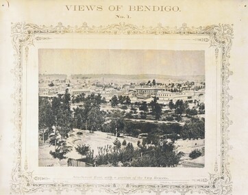
Photograph - NICHOLAS CAIRE VIEWS OF BENDIGO
... New Masonic Hall, Sandhurst. 33) The Bendigo benevolent asylum and industrial school. 34) Bendigo flat as seen from Wattle Hill. 35) View of Old Chum Hill. 36) New Chum Gully as seen from Specimen Hill. 37) Township of Eaglehawk. 38) View from St. Paul's tower looking south west. 39) View of the railway tunnel through the Big Hill, near Mt. Herbert. 40) View taken from St. Paul's looking south. 41) Scene taken from St. Paul's tower looking eastward. 42) View of Sandhurst from St. Paul's tower looking north-west. 43) The great extended Hustler's co's...New Masonic Hall, Sandhurst. 33) The Bendigo benevolent asylum and industrial school. 34) Bendigo flat as seen from Wattle Hill. 35) View of Old Chum Hill. 36) New Chum Gully as seen from Specimen Hill. 37) Township of Eaglehawk. 38) View from St. Paul's tower looking south west. 39) View of the railway tunnel through the Big Hill, near Mt. Herbert. 40) View taken from St. Paul's looking south. 41) Scene taken from St. Paul's tower looking eastward. 42) View of Sandhurst from St. Paul's tower looking north-west. 43) The great extended Hustler's co's ...Full set (52 photos) of Nicholas Caire ''Views of Bendigo'' photographs. 1) Sandhurst East with a portion of the City Reserve. 2) New Chum line of reef. 3) Sandhurst-North part as seen from the top of the Masonic Hall. 4) The Hustler's line of reef seen from Redan Hill. 5) Battery of stampers for crushing quartz 6) View of Sandhurst as seen from the top of the New Masonic Hall. 7) Excavation of quartz reef near Ironbark Hill. 8) St. Paul's Church, tower and belfry. 9) View of the Camp Reserve as seen from the Court House. 10) View of North Old Chum showing surface excavations. 11) View as seen from the Camp Hill near the lodge. 12) Garden Gully amalgamated claims. 13) Shamrock Hotel, Sandhurst. 14) View as seen from Court House showing the willows & East Pall Mall. 15) Wesleyan Church, Golden Square. 16) Savings bank, Sandhurst. 17) The Bendigo district hospital. 18) Interior of the Wesleyan Church, Golden Square. 19) View of Golden Square township. 20) The Town Hall, City of Sandhurst. 21) The City Hotel, Sandhurst. 22) Pall Mall, Sandhurst. 23) Sandhurst City Market. 24) Pall Mall, Sandhurst looking west. 25) View from Camp Hill looking north - east 26) View of Charing Cross, Sandhurst. 27) View of Sandhurst as seen from Knipe's Castle. 28) Township of Long Gully. 29) View taken from St. Paul's tower. 30) View of the Sandhurst cemetery at back creek. 31) Kock's pioneer quartz crushing plant, Long Gully. 32) The New Masonic Hall, Sandhurst. 33) The Bendigo benevolent asylum and industrial school. 34) Bendigo flat as seen from Wattle Hill. 35) View of Old Chum Hill. 36) New Chum Gully as seen from Specimen Hill. 37) Township of Eaglehawk. 38) View from St. Paul's tower looking south west. 39) View of the railway tunnel through the Big Hill, near Mt. Herbert. 40) View taken from St. Paul's looking south. 41) Scene taken from St. Paul's tower looking eastward. 42) View of Sandhurst from St. Paul's tower looking north-west. 43) The great extended Hustler's co's. quartz mining claim. 44) View from the Big Hill showing the line of railway to Melbourne. 45) View from St. Paul's Church tower looking westward. 46) View from St. Paul's Church tower looking north-west. 47) Scene near the Big Hill ranges taken from Mr. Buick's residence. 48) View from St. Paul's Church tower looking north eastward. 49) Township of Eaglehawk 50) View of Mitchell Street, Sandhurst. 51) Botanical gardens near the White Hills. 52) View Point, Sandhurst.bendigo, streetscape, various views, nicholas cairne -
 Bendigo Historical Society Inc.
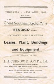
Document - IAN DYETT COLLECTION: AUCTION CATALOGUE - GREAT SOUTHERN GOLD MINE
... Co...Garden Gully Line of Reef... Fortuna Hustlers Mine... Carshalton Line... Red White and Blue Consolidated... New Chum Railway...History House 11 Mackenzie Street Bendigo goldfields BUSINESS Auctioneers j h curnow & son pty ltd Ian Dyett Collection - Auction Catalogue - Great Southern Gold Mine J H Curnow & Son Pty Ltd Prahran telegraph Printing Co Garden Gully Line of Reef Fortuna Hustlers Mine Carshalton Line Red White and Blue Consolidated New Chum Railway Whip and Jersey Small catalogue for an auction sale at the Great Southern Gold Mine on the Garden Gully Line of Reef. ...Small catalogue for an auction sale at the Great Southern Gold Mine on the Garden Gully Line of Reef. Lease Nos. 11033 and 10690. Auction of Leases, Plant, Buildings and Equipment was held on 10th April 1947. J. H. Curnow & Son Pty Ltd. Were the auctioneers. Contains description of machinery and circular brick smoke stack.business, auctioneers, j h curnow & son pty ltd, ian dyett collection - auction catalogue - great southern gold mine, j h curnow & son pty ltd, prahran telegraph printing co, garden gully line of reef, fortuna hustlers mine, carshalton line, red white and blue consolidated, new chum railway, whip and jersey -
 Bendigo Historical Society Inc.
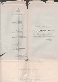
Map - STRUGNELL COLLECTION: UNDERGROUND SURVEY OF MINES BENDIGO, 27-3-01
... Co., New Chum Line, Bendigo. Transverse Section, Garibaldi Reef, Young Chum Reef, Thorpe's Reef, Mundic Reef, Shenandoah Reef, New Chum Railway Reef, Surveyed under the Supervision of H.Herman....Co., New Chum Line, Bendigo. Transverse Section, Garibaldi Reef, Young Chum Reef, Thorpe's Reef, Mundic Reef, Shenandoah Reef, New Chum Railway Reef, Surveyed under the Supervision of H.Herman. ...Map, Underground Survey of Mines, Shamrock Co., New Chum Line, Bendigo. Transverse Section, Garibaldi Reef, Young Chum Reef, Thorpe's Reef, Mundic Reef, Shenandoah Reef, New Chum Railway Reef, Surveyed under the Supervision of H.Herman.H.S.Whitelaw.map, bendigo, shamrock co. -
 Bendigo Historical Society Inc.
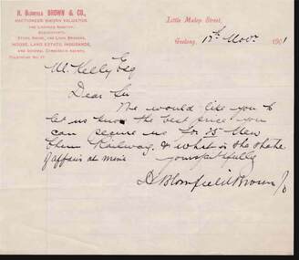
Document - KELLY AND ALLSOP COLLECTION: H. BLOMFIELD BROWN & CO, 12/11/1901
... Co.... M Kelly Esq.... New Chum Railway...Blomfield Brown & Co. M Kelly Esq. New Chum Railway H Blomfield Brown Note from H. ...Note from H. Blomfield Brown to Mr Kelly Esq. to let him know the best price he can secure for 25 New Chum Railway and what is the state of affairs at the mine. Signed by H Blomfield Brown.business, stockbroker, kelly & allsop, kelly & allsop collection - h. blomfield brown & co., m kelly esq., new chum railway, h blomfield brown -
 Bendigo Historical Society Inc.
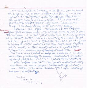
Document - ARTICLES FOR ROYAL HISTORICAL SOCIETY (BENDIGO BRANCH) JUNE 1973
... Article re two aspects of New Chum Railway mine - a. the shaft has a 180 degree 'twist' in it; b. ventilation problems at depth (4236 feet level); 2. Specimen Hill Methodist Church - mention of Mining Inspector Grainger; Mr Widdox; Blazier (Braizer)?? & Co...Article re two aspects of New Chum Railway mine - a. the shaft has a 180 degree 'twist' in it; b. ventilation problems at depth (4236 feet level); 2. Specimen Hill Methodist Church - mention of Mining Inspector Grainger; Mr Widdox; Blazier (Braizer)?? & Co ...Articles for Royal Historical Society (Bendigo Branch) June 1973. 1. Article re two aspects of New Chum Railway mine - a. the shaft has a 180 degree 'twist' in it; b. ventilation problems at depth (4236 feet level); 2. Specimen Hill Methodist Church - mention of Mining Inspector Grainger; Mr Widdox; Blazier (Braizer)?? & Co - contractors; Rev. Rankin; Mr Manley; Brass Band; Rev. Winn. 2. ''The new bells - St Paul's Church, Bendigo'' - mention of Mears and Stainbank (Bell Foundry, Whitechapel, London); Rt Rev R E Richards (Bishop of Bendigo); re-casting of bells 1964. 3. Article re artificial ventilation re West Berry Consols Mine (Allendale) and use of a Roots Blower. 4. Article ''It slowly fades away'' re demolition of 46 Lucan Street (see also Moaic #2860) - mention of Thunders Brewery; Bendigo Cognac Distillery; Cyril Michelsen; John Michelsen; description of vats and layout of site.document, names of bendigo pioneers, bendigo -
 Bendigo Historical Society Inc.
Document - NOTES ON BENDIGO MINES
... New Moon... Carlisle... Nth Garden Gully... Passby... Old Carlisle...Kentish... Central Garden Gully... Golden Fleece... Garden Gully United... Big Blue... Union Co... Red... White & Blue... New Chum Railway...Mines mentioned are: South New Moon, Carlisle, Nth Garden Gully, Passby, Old Carlisle,Kentish, Central Garden Gully, Golden Fleece, Garden Gully United, Big Blue, Union Co, Red, White & Blue, New Chum Railway, Unity, Cornish, Catherine Reef United, Garden Gully United, Gt Extended Hustlers, Gt Northern, Lady Barkly, New Moon, South St Mungo, Virginia and Victoria Quartz, Document from Albert Richardson Collection of mining history....History House 11 Mackenzie Street Bendigo goldfields DOCUMENT Gold notes on bendigo mines Notes on Bendigo Mines South New Moon Carlisle Nth Garden Gully Passby Old Carlisle Kentish Central Garden Gully Golden Fleece Garden Gully United Big Blue Union Co Red White & Blue New Chum Railway Unity Cornish Catherine Reef United Garden Gully United Gt Extended Hustlers Gt Northern Lady Barkly New Moon South St Mungo Virginia Victoria Quartz Graham Tenby and Ashman Mr J B Watson Geo Lansell Mines Dept D E Thomas Handwritten notes on Bendigo Mines. ...Handwritten notes on Bendigo Mines. Notes include area of lease, yards along the reef, depth, dividends, main shafts within one mile of Bendigo Station and shafts made safe by the Mines Dept. Mines mentioned are: South New Moon, Carlisle, Nth Garden Gully, Passby, Old Carlisle,Kentish, Central Garden Gully, Golden Fleece, Garden Gully United, Big Blue, Union Co, Red, White & Blue, New Chum Railway, Unity, Cornish, Catherine Reef United, Garden Gully United, Gt Extended Hustlers, Gt Northern, Lady Barkly, New Moon, South St Mungo, Virginia and Victoria Quartz, Document from Albert Richardson Collection of mining history.document, gold, notes on bendigo mines, notes on bendigo mines, south new moon, carlisle, nth garden gully, passby, old carlisle, kentish, central garden gully, golden fleece, garden gully united, big blue, union co, red, white & blue, new chum railway, unity, cornish, catherine reef united, garden gully united, gt extended hustlers, gt northern, lady barkly, new moon, south st mungo, virginia, victoria quartz, graham, tenby and ashman, mr j b watson, geo lansell, mines dept, d e thomas -
 Bendigo Historical Society Inc.
Document - NEW CHUM & VICTORIA LINES OF REEF - NEW CHUM RAILWAY MINE MANAGER'S REPORT 1880 - 84
... New Chum & Victoria Lines of Reef... New Chum Railway Mine Manager's Report 1880 - 84... Mr J Alderson... O'Rourke and Henderson... Allingham... Aitkens... Pandora... Richard Heals... Flat Ropes... Young Chum Co...History House 11 Mackenzie Street Bendigo goldfields DOCUMENT Gold New Chum & Victoria Lines of Reef New Chum Railway Mine Manager's Report 1880 - 84 Mr J Alderson O'Rourke and Henderson Allingham Aitkens Pandora Richard Heals Flat Ropes Young Chum Co Horwood's Old Chum Harkness Crushing Mill G Armstrong Roberts & Sons Eureka Coy Handwritten excerpts from Mine Manager's Reports from January 1880 to May 1884. ...Handwritten excerpts from Mine Manager's Reports from January 1880 to May 1884. Mine Manager Mr. J Alderson. Items mentioned: telephones, mechanical breakdowns, air supply, trouble with flat ropes, water problems, leaning and testing boiler engines.document, gold, new chum & victoria lines of reef, new chum railway mine manager's report 1880 - 84, mr j alderson, o'rourke and henderson, allingham, aitkens, pandora, richard heals, flat ropes, young chum co, horwood's, old chum, harkness, crushing mill, g armstrong, roberts & sons, eureka coy -
 Bendigo Historical Society Inc.
Document - NEW CHUM LINE OF REEF - REFERENCE FOR CALEB THOMAS PLANS
... New Chum Line of Reef... Reference for Caleb Thomas Plans... New Chum Bellevue & Railway Reserve... Bellevue & New Chum... Shenandoah... Shamrock... Old Chum... Little Chum... New Chum Trib... Young Chum... Cravens... Garibaldi... No 1 Ellesmere Coy... New Chum Consolidated... Ellesmere... New Chum United... Lansell's 222 (denis)... Lansell's 222 (New Shaft)... Koch & Hildebrandt (Lansell's 222)... Lazarus Co...History House 11 Mackenzie Street Bendigo goldfields DOCUMENT Gold New Chum Line of Reef Reference for Caleb Thomas Plans New Chum Bellevue & Railway Reserve Bellevue & New Chum Shenandoah Shamrock Old Chum Little Chum New Chum Trib Young Chum Cravens Garibaldi No 1 Ellesmere Coy New Chum Consolidated Ellesmere New Chum United Lansell's 222 (denis) Lansell's 222 (New Shaft) Koch & Hildebrandt (Lansell's 222) Lazarus Co Sheer Legs Old Chum New Chum & Victoria North Old Chum Lansell's 180 Victoria Quartz Gt Cent Vic Victoria Consols Victoria Reef Co (Ironbark) Hercules Energetic Ladder Shaft Energetic Shaft Two handwritten pages of reference numbers for Caleb Thomas plans. ...Two handwritten pages of reference numbers for Caleb Thomas plans. The numbers refer to mines on the New Chum Line of Reef.document, gold, new chum line of reef, reference for caleb thomas plans, new chum bellevue & railway reserve, bellevue & new chum, shenandoah, shamrock, old chum, little chum, new chum trib, young chum, cravens, garibaldi, no 1 ellesmere coy, new chum consolidated, ellesmere, new chum united, lansell's 222 (denis), lansell's 222 (new shaft), koch & hildebrandt (lansell's 222), lazarus co, sheer legs, old chum, new chum & victoria, north old chum, lansell's 180, victoria quartz, gt cent vic, victoria consols, victoria reef co (ironbark), hercules, energetic ladder shaft, energetic shaft -
 Bendigo Historical Society Inc.
Document - VICTORIA HILL - RECOMMENDATIONS FOR VICTORIA HILL
... New Chum Railway Mine... Fortuna Hustlers G M Co Bendigo...Ballerstedt's Crushing Battery at Victoria Hill, Thompson's Foundry at Castlemaine, Machinery made for Bendigo Mines, Air Compressor at Shenandoah Mine, Winding Engine at Koch's Pioneer Mine, Poppet Legs at Koch's Pioneer Mine, Air Compressor at New Chum Railway Mine, Fortune Hustlers G M Co Bendigo View of Mine, Winding Plant and Afternoon Shift and Underground Work in the New Chum Railway. ...Ballerstedt's Crushing Battery at Victoria Hill, Thompson's Foundry at Castlemaine, Machinery made for Bendigo Mines, Air Compressor at Shenandoah Mine, Winding Engine at Koch's Pioneer Mine, Poppet Legs at Koch's Pioneer Mine, Air Compressor at New Chum Railway Mine, Fortune Hustlers G M Co Bendigo View of Mine, Winding Plant and Afternoon Shift and Underground Work in the New Chum Railway. ...BHS CollectionHandwritten notes on recommendations for cleaning up and signposting Victoria Hill. Also contains list of photos from the Bendigonian of 1899. List of photos: Shamrock Mine, Undershot Water Wheel at Diamond Hill for Phillips Crushing Battery. Mr. Ballerstedt's Crushing Battery at Victoria Hill, Thompson's Foundry at Castlemaine, Machinery made for Bendigo Mines, Air Compressor at Shenandoah Mine, Winding Engine at Koch's Pioneer Mine, Poppet Legs at Koch's Pioneer Mine, Air Compressor at New Chum Railway Mine, Fortune Hustlers G M Co Bendigo View of Mine, Winding Plant and Afternoon Shift and Underground Work in the New Chum Railway. Also mentioned are notes on Machinery made by Thompsons. Also, a carbon copy of Annual Report to Bendigo Branch Royal Historical Society, Victoria 1/7/71. Mentioned in the Report are: Historical Ball, The Central Deborah, Victoria Hill, Tours and Society Business. Albert Richardson document?document, victoria hill, recommendations for victoria hill, north old chum, ballerstedt's rich 24 yard claim, floyds battery lansell's big 180, the bendigonian 26/1/1899, 2/2/1899, 20/4/1899, 11/5/1899, 10/8/1899, 14/9/1899, shamrock mine, undershot waterwheel at diamond hill, phillips crushing battery, mr ballerstedt's crushing battery, thompson's foundry, shenandoah mine, koch's pioneer mine, new chum railway mine, fortuna hustlers g m co bendigo, new chum railway, st mungo lady barkly, catherine reef, new moon, rae's open cut, old court house eaglehawk, police barracks, vic wodetzki, joss house, central deborah, central nell gwynne, mr harold curnow, bendigo branch royal historical society victoria, mrs kingerlee, felicity kingerlee, mr h biggs, city council, rotary club of bendigo south, white hills cemetry, chinese joss house, bendigo pottery, mr derham, reservoir high, princess theatre, a n a hall, mr hattam, col. sprenger, survey corps, a richardson -
 Bendigo Historical Society Inc.
Document - VICTORIA HILL - BENDIGO BRANCH HISTORICAL SOCIETY - MINE TOUR
... New Chum Goldfields... Central Wattle Gully Mine Chewton... Virginia Consols... Black's Quarries Coldstream... Thompson's Engineering and Pipe Co Ltd Castlemaine... New Chum Railway...History House 11 Mackenzie Street Bendigo goldfields DOCUMENT Gold Victoria Hill Bendigo Branch Historical Society Mine Tour All Saints Church Joseph La Trobe Bendigo's First Hospital Sacred Heart Cathedral The Central Deborah Mine City Council Londonderry West Shaft New Red White and Blue Consolidated (Big Blue) A Roberts & Sons Big Deborah The New Golden Fleece New Chum Goldfields Central Wattle Gully Mine Chewton Virginia Consols Black's Quarries Coldstream Thompson's Engineering and Pipe Co Ltd Castlemaine New Chum Railway Mine Golden Square Methodist Church The Rocks E J Dunn Gold Monument Shamrock Mine Mt Alvernia Hospital J B Lazarus John Brown Knitwear Factory Gold fMines Hotel David Sterry New Chum Hill Fortuna Villa Geo Lansell Theodore Ballerstedt A H Q Survey Regiment Headquarters Old Chum Mine Central Nell Gwynne Rae's Open Cut Theodore Ballerstedt New Chum Syncline Little 180 Mine Victoria Quartz Wittcheibe's 'Jeweller's Shop' Adventure Advance Cinderella J N Macartney Bendigo Goldfields Registry 1870 Wm Rae Johnson's Devonshire Mine Snobs Hill Mine Ellenborough Mullock Heap Belmont Mullock Heap Sadowa St Mungo United Devonshire Mechanic's Institute Log Lock-Up Court House J B Watson Housing Commission Homes Hustlers Hill Latham and Watsons' The Great Extended Hustlers A Richardson Typed notes for a tour of the area. ...Typed notes for a tour of the area. Areas mentioned are: Hospital Hill, The Central Deborah Mine, New Chum Railway Mine, The Rocks, New Chum Hill, Victoria Hill, Central Nell Gwynne, Rae's Open Cut, Housing Commission Homes and Latham and Watson's. Description of machinery at the Central Deborah Mine, yields, dividends, depth of shafts and directions to get ot the various places is included.document, gold, victoria hill, bendigo branch historical society mine tour, all saints church, joseph la trobe, bendigo's first hospital, sacred heart cathedral, the central deborah mine, city council, londonderry west shaft, new red, white and blue consolidated (big blue), a roberts & sons, big deborah, the new golden fleece, new chum goldfields, central wattle gully mine chewton, virginia consols, black's quarries coldstream, thompson's engineering and pipe co ltd castlemaine, new chum railway mine, golden square methodist church, the rocks, e j dunn, gold monument, shamrock mine, mt alvernia hospital, j b lazarus, john brown knitwear factory, gold fmines hotel, david sterry, new chum hill, fortuna villa, geo lansell, theodore ballerstedt, a h q survey regiment headquarters, old chum mine, central nell gwynne, rae's open cut, theodore ballerstedt, new chum syncline, little 180 mine, victoria quartz, wittcheibe's 'jeweller's shop', adventure, advance, cinderella, j n macartney, bendigo goldfields registry 1870, wm rae, johnson's devonshire mine, snobs hill mine, ellenborough mullock heap, belmont mullock heap, sadowa, st mungo, united devonshire, mechanic's institute, log lock-up, court house, j b watson, housing commission homes, hustlers hill, latham and watsons', the great extended hustlers, a richardson -
 Bendigo Historical Society Inc.
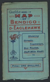
Map - GUIDE MAP OF BENDIGO & EAGLEHAWK, Late 1920's
... New Chum Railway 4,318 ft., 13 mines over 3,000ft. deep, 53 mines over 2,000 ft. deep. Sewering of City commenced 1922. All principal buildings now sewered. Map printed by Arnall & Jackson, General Printers, Stationers & Engravers, 476 Collins Street. Outer map blue cover printed in red and blue ink by J B Young, Lithographer. Map displays advertisement for Bendigo Timber Co...New Chum Railway 4,318 ft., 13 mines over 3,000ft. deep, 53 mines over 2,000 ft. deep. Sewering of City commenced 1922. All principal buildings now sewered. Map printed by Arnall & Jackson, General Printers, Stationers & Engravers, 476 Collins Street. Outer map blue cover printed in red and blue ink by J B Young, Lithographer. Map displays advertisement for Bendigo Timber Co ...Map. Guide map of Bendigo & Eaglehawk. Folded map of Bendigo & Eaglehawk with blue outer cover booklet. Map is compiled by E E Parker, Eaglehawk. Map shows tramways, bus routes and cost one shilling. Map shows Agricultural Showgrounds located between Park Street, Water Street, Barnard Street and Bridge Lane. Also shows Acclimitization Reserve located behind the Botanical Gardens at White Hills. Shows the location of Sailors Gully, Peg-Leg Gully, Jobs Gully, California Gully, Long Gully, Ironbark Gully, Golden Gully, Poverty Gully, Sheepshead Gully, Charcoal Gully, Eaglehawk Creek, Bendigo Creek and Back Creek.Contains interesting facts about Bendigo:- Area - 7,900 acres, Population - 26,000, First Council elected - 1855, Proclaimed a City - 1871. Gold Rush broke out - 1851. For first 10 years gold yield averaged 8,600 ozs. Per week. Total gold yield to 1923 - 572 tons valued at 82,000,000 pounds. Deepest mines - Victoria Quartz 4,614 ft., New Chum Railway 4,318 ft., 13 mines over 3,000ft. deep, 53 mines over 2,000 ft. deep. Sewering of City commenced 1922. All principal buildings now sewered. Map printed by Arnall & Jackson, General Printers, Stationers & Engravers, 476 Collins Street. Outer map blue cover printed in red and blue ink by J B Young, Lithographer. Map displays advertisement for Bendigo Timber Co. Outer blue cover displays advertisement for Campbell Connelly & Co. Pty. Ltd, Ironmongers, Timware Manufacturers, Plumbers, Sewerage Contractors, High and Forest Sts, Bendigo 9outside back cover) and for Hartleys ( J L Shoosmith) Bendigo, displaying Indian Motor Cycles (inside back cover).map, bendigo, township, guide map of bendigo & eaglehawk -
 Bendigo Historical Society Inc.
Plan - DEBORAH REEF CROSS SECTION
... There is also a map, scale 8 chains to an inch showing the Melbourne Echuca railway and reefs on both sides of Deborah reef including Carshalton, Napoleon, Nell Gwynne, New Chum, Sheepshead, Garden Gully, Paddy's Gully, Derby and names some mines and dividends, Whip and Jersey £200,000, Lansell's Napoleon, Railway Goldfields, New Chum Railway £170,000, Lansell's Red White and Blue Consolidated, Great Southern Co £160,000, Fortuna Hustlers £40,000 It is signed A H Cundy 19.12.17 Forms part of the Margaret Roberts Collection ...There is also a map, scale 8 chains to an inch showing the Melbourne Echuca railway and reefs on both sides of Deborah reef including Carshalton, Napoleon, Nell Gwynne, New Chum, Sheepshead, Garden Gully, Paddy's Gully, Derby and names some mines and dividends, Whip and Jersey £200,000, Lansell's Napoleon, Railway Goldfields, New Chum Railway £170,000, Lansell's Red White and Blue Consolidated, Great Southern Co £160,000, Fortuna Hustlers £40,000 It is signed A H Cundy 19.12.17 Forms part of the Margaret Roberts Collection Plan DEBORAH REEF CROSS SECTION ...OBITUARY MR. W. H. CUNDY PROMINENT FOOTBALLER. The news of the death in a private hospital at Bendigo (VIC.) on Monday of Mr. William Henry Cundy, a geologist and mining engineer, who was regarded as one of the greatest authorities on the Bendigo gold field, was received in Launceston with deep regret. A native of Hobart, Mr. Cundy, who was 71 years of age, went to Bendigo from Tasmania in 1893 to an appointment in the Mines Department, subsequently, in association with Mr. E. J. Dunn, undertaking the task of making a special report on the Bendigo gold fields, and also of charting the lines of reef. He was keenly interested in mining ventures in Tasmania, and his services were in constant demand to investigate and report on shows, particularly gold and tin. In his younger days, at Hobart, Mr. Cundy was a champion footballer, and brought about the modification of the rules of the game in Tasmania. While in Bendigo he was captain of Sandhurst for many years, and a past-president of the Bendigo Football League. He was a widower. Mercury (Hobart, Tas.: 1860 - 1954), Friday 15 February 1935, page 6) A blueprint draftsman's drawing of a cross section of the Deborah Reef to a depth of 435 feet, scale 40 feet to an inch. There is also a map, scale 8 chains to an inch showing the Melbourne Echuca railway and reefs on both sides of Deborah reef including Carshalton, Napoleon, Nell Gwynne, New Chum, Sheepshead, Garden Gully, Paddy's Gully, Derby and names some mines and dividends, Whip and Jersey £200,000, Lansell's Napoleon, Railway Goldfields, New Chum Railway £170,000, Lansell's Red White and Blue Consolidated, Great Southern Co £160,000, Fortuna Hustlers £40,000 It is signed A H Cundy 19.12.17 Forms part of the Margaret Roberts Collection bendigo, margaret roberts, gold, map, mine, w h cundy