Showing 5334 items matching "no road sign"
-
 Puffing Billy Railway
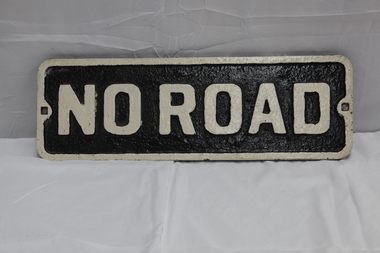
No Road - End of platform sign
... No Road - End of platform sign......no road sign...Historic - Railway - No Road Plate Sign ...No Road Plate Sign Long rectangular plate that has been painted black and white with the words "no road" written across it. made of cast metal...Puffing Billy Railway 1 old monbulk road Belgrave yarra-valley-and-the-dandenong-ranges Historic - Railway - No Road Plate Sign Historic - Railway - No Road Plate Sign puffing billy sign plate no road sign "No Road" No Road Plate Sign Long rectangular plate that has been painted black and white with the words "no road" written across it. made of cast metal No Road - End of platform sign ...Historic - Railway - No Road Plate Sign Historic - Railway - No Road Plate Sign No Road Plate Sign Long rectangular plate that has been painted black and white with the words "no road" written across it. made of cast metal"No Road"puffing billy, sign, plate, no road sign -
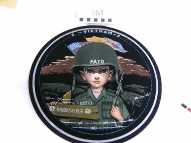
 National Vietnam Veterans Museum (NVVM)
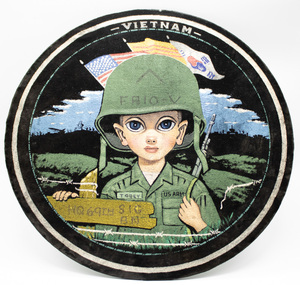
Artwork, other - Painting, on velvet
... He is holding a road sign. "Tobey" on his right pocket....On helmet: FAID-V ( written in pen) . On road sign: HQ69th Sig B.N. VIETNAM printed in white on top of disc....He is holding a road sign. "Tobey" on his right pocket. Artwork, other Painting, on velvet ...Round black velvet disc with caricature-style image of a soldier in US Army battle dress with a rifle over his left shoulder painted on it . Flags of America, Vietnam and Korea are in the background. He is holding a road sign. "Tobey" on his right pocket.On helmet: FAID-V ( written in pen) . On road sign: HQ69th Sig B.N. VIETNAM printed in white on top of disc.plaque, america, craft, art, souvenir, us soldier -
 Bendigo Historical Society Inc.
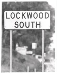
Photograph - BENDIGO ADVERTISER COLLECTION: ROAD SIGN OF LOCKWOOD SOUTH, 10/08/1993
... BENDIGO ADVERTISER COLLECTION: ROAD SIGN OF LOCKWOOD SOUTH...Road sign of Lockwood South....History House 11 Mackenzie Street Bendigo goldfields REGION Small towns Lockwood South Bill Hawkins Road sign of Lockwood South. Photograph BENDIGO ADVERTISER COLLECTION: ROAD SIGN OF LOCKWOOD SOUTH ...Road sign of Lockwood South.Bill Hawkinsregion, small towns, lockwood south -
 Vision Australia
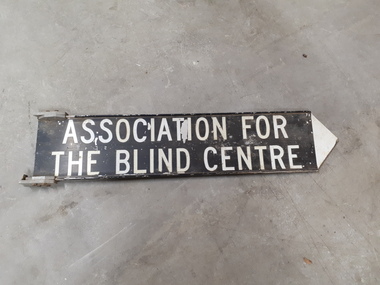
Sign - Image, Street sign for the Association for the Blind
... Black and white road sign...Vision Australia 454 Glenferrie Road Kooyong melbourne A metal street sign with a black background and white writing and a white pointing tip at the end, indicating which direction the Association for the Blind was located. association for the blind Nameplates Association for the Blind Centre Black and white road sign Street sign for the Association for the Blind Sign Image ...A metal street sign with a black background and white writing and a white pointing tip at the end, indicating which direction the Association for the Blind was located.Black and white road signAssociation for the Blind Centreassociation for the blind, nameplates -
 Falls Creek Historical Society
Poster - Kangaroo Hoppet 2011
... A Kangaroo Hoppet road sign is on the left. The page border is yellow. ...At the top: Kangaroo HOPPET 21 Australia's PREMIER X-COUNTRY SKI RACE On the road sign: KANGAROO HOPPET 42km Beneath the image 27th August 2011/ 42KM 21KM 7KM Below the line of logos: Ph. 03 5754 1045 / [email protected] www.hoppet.com.au Across the bottom in larger cursive text www.hoppet.com.au...A Kangaroo Hoppet road sign is on the left. The page border is yellow. ...The Kangaroo Hoppet is Australia’s premier long distance cross country ski race, and a member of the Worldloppet series of international cross country ski events. After running the event for 10 years, it was decided they should become part of the Worldloppet series of marathon ski races. Representatives from the Birkebeiner Nordic Ski Club and the Australian Ski Federation attended the Worldloppet Annual Meeting in Finland in June 1990 to put the case for the acceptance of an Australian event into the Worldloppet series. Before being admitted, they had to demonstrate that the Birkebeiner Club could run a world class event, so three months later in August 1990 a 42km event named the Australian International Ski Marathon was held at Falls Creek together with a 21km Birkebeiner race and a 7km event called the Birkebeiner Lite. The event was approved by delegates from USA, Norway and Austria, in 1991 Australia became the 12th member of Worldloppet, with the condition that there had to be a name change. After some late night discussion allegedly involving red wine from North East Victoria the main event became the 42km Kangaroo Hoppet, with the minor events being the 21km Australian Birkebeiner, and 7km Joey Hoppet. In the winter of 1991, the first Kangaroo Hoppet was held. It was a great success and has been a regular fixture on the international ski calendar ever since. It features the main 42km event as well as a 21km event and a 7km event. The Hoppet brings the Australian snowfields to an international audience. In 2011 the Men's Winner was Petr Novak from the Czech Republic in a time of 1:16:04. The winner of the Women's event was Esther Bottomley of Australia in a time of 1:42:22. Due to lack of snow, the course had to be relocated to the Mt McKay area at the top of the ski resort. The 42km Hoppet course was shortened to 30km.This poster is significant because it documents an event which brings international attention to Falls Creek and the surrounding region.A poster featuring a group of competitors from a previous Hoppet event. A Kangaroo Hoppet road sign is on the left. The page border is yellow. Logos of AGL, Falls Creek All Season Alpine Resort, Alpine Shire, Tourism Victoria, Parks Victoria and the Birkebeiner Nordic Ski Club are across the bottom of the poster.At the top: Kangaroo HOPPET 21 Australia's PREMIER X-COUNTRY SKI RACE On the road sign: KANGAROO HOPPET 42km Beneath the image 27th August 2011/ 42KM 21KM 7KM Below the line of logos: Ph. 03 5754 1045 / [email protected] www.hoppet.com.au Across the bottom in larger cursive text www.hoppet.com.aukangaroo hoppet, worldloppet events, falls creek, mt. beauty -
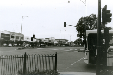
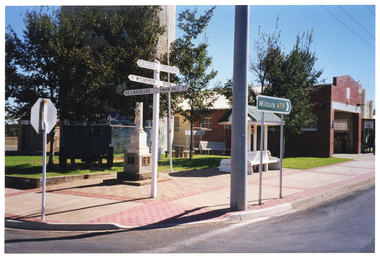 Musculoskeletal Health Australia (now held by the Glen Eira Historical Society)
Photograph - Street View, XX/04/1999
... A larger road sign indicates the route to the town of Mildura. ...COL photo of some directional road signs, a cenotaph, and a wooden bench with an overhead shelter on a paved area next to a building. ...A larger road sign indicates the route to the town of Mildura. ...In April 1999, Arthritis Foundation of Victoria staff travelled to Merbein, Sea Lake, and Mildura during National Arthritis Week (NAW). These visits were conceived as part of the Rural Access Project. This photo depicts a street view of a cenotaph, a covered wooden bench, and some directional road signs in Sea Lake, on route to Mildura. The cenotaph is dedicated to the memory of Trooper John Kiley (of the Victorian Imperial Battalion Bushmen, D Squardon). The wooden bench commemorates Councillor James Mudge. Both are located on Horace St (Calder Hwy), on the corner of Best St, Sea Lake. In the foreground, there is a directional road sign indicating 'CALDER HIGHWAY' and directions to various nearby towns. A larger road sign indicates the route to the town of Mildura. At that time, the Sea Lake District War Memorial had not yet been erected, but it now stands between the cenotaph and the wooden bench. The Sea Lake Visitor Information Centre is currently located on the property next door.COL photo of some directional road signs, a cenotaph, and a wooden bench with an overhead shelter on a paved area next to a building. In the foreground, one directional sign indicates 'CALDER HIGHWAY' and directions to various locations nearby, such as: 77 WYCHEPROOF; OUYEN (partially obscured); 33 LASCELLES; and SWAN HILL 77. A larger green directional sign indicates Route A79 to the town of Mildura.arthritis foundation of victoria, afv, rural access project, outreach, street signs, road signs, directional signs, war memorial, cenotaph, trooper john kiley, commemorative bench, cr james mudge, horace st, best st, sea lake, 1999 -
 Stawell Historical Society Inc
Photograph, Old Adelaide Road - Roses Gap, 29/04/1997
... 2 Colour Photographs; 1 Showing Old Adelaide road sign. 1 Large group of people outside....Stawell Historical Society Inc 46 Longfield St Stawell grampians Roses Gap 2 Colour Photographs; 1 Showing Old Adelaide road sign. 1 Large group of people outside. Old Adelaide Road - Roses Gap Photograph ...2 Colour Photographs; 1 Showing Old Adelaide road sign. 1 Large group of people outside.roses gap -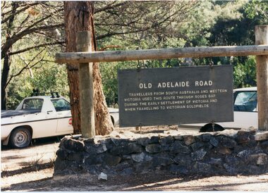
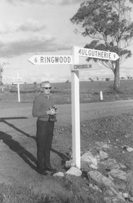 Ringwood and District Historical Society
Photograph, Hampshire, England. Road sign indicating distance to Ringwood. Undated
... Hampshire, England. Road sign indicating distance to Ringwood. Undated....Catalogue card reads, "Hampshire, England. Road sign indicating distance to Ringwood". ...No date Hampshire, England. Road sign indicating distance to Ringwood. Undated. ...Catalogue card reads, "Hampshire, England. Road sign indicating distance to Ringwood". Man is unidentified. No date -
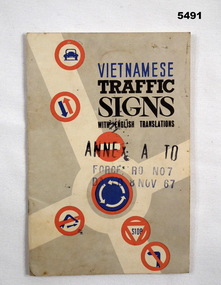 Bendigo Military Museum
Booklet - VIETNAMESE TRAFFIC SIGNS, C 1962-1972
... Grey and white with road signs in red and blue. !5 pages of traffic signs. ...Grey and white with road signs in red and blue. !5 pages of traffic signs. ...See Cat 5490.Booklet- cardboard cover, bound with 2 staples. Grey and white with road signs in red and blue. !5 pages of traffic signs. Front cover- “Vietnamese Traffic Signs, with English Translations”Cvietnam war, book -
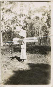 Halls Gap & Grampians Historical Society
Photograph - B/W, C 1950s (?)
... The photo shows a woman standing in front of road signs at a road junction. The visible signs read "17 Stawell" and "163 Melbourne" to the left and "Halls Gap 1" and "Dunkeld 49" to the right....PEOPLE Tourists The photo shows a woman standing in front of road signs at a road junction. The visible signs read "17 Stawell" and "163 Melbourne" to the left and "Halls Gap 1" and "Dunkeld 49" to the right. ...The woman is Mrs. Ron Groves, formerly Dulcie Stevenson, Cheltenham.The photo shows a woman standing in front of road signs at a road junction. The visible signs read "17 Stawell" and "163 Melbourne" to the left and "Halls Gap 1" and "Dunkeld 49" to the right.people, tourists -
 National Wool Museum
Photograph, Collins Bros Mill Pty Ltd, Physician Blanket Road Sign, Unknown
... Physician Blanket Road Sign...Black and white photograph showcasing the Physician Blanket advertising road sign above a two story building in a landscape format. ...Physician Blanket Road Sign Photograph Photograph Collins Bros Mill Pty Ltd ...Advertising sign for the Physician Blankets Manufactured by Collins Bros Pty Ltd. Black and white photograph showcasing the Physician Blanket advertising road sign above a two story building in a landscape format. The road and moving cars are in the foreground.Front centre - Physician Chillproof Blankets. Sign Rear - Physician Brisbane (?) (?) Signwool, woollen mills, wool manufacture -
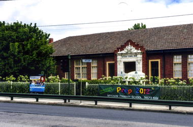 Whitehorse Historical Society Inc.
Photograph, Mitcham State School No 2904, 2012
... Coloured photograph of the Mitcham State School situated on the west side of Mitcham Road, opposite East Doncaster Road. Sign on the fence requesting 2012 prep enrolments....Whitehorse Historical Society Inc. 2-10 Deep Creek Road Mitcham melbourne See NP3945 mitcham state school no 2904 state schools Coloured photograph of the Mitcham State School situated on the west side of Mitcham Road, opposite East Doncaster Road. Sign on the fence requesting 2012 prep enrolments. ...See NP3945Coloured photograph of the Mitcham State School situated on the west side of Mitcham Road, opposite East Doncaster Road. Sign on the fence requesting 2012 prep enrolments.mitcham state school no 2904, state schools -
 Wodonga & District Historical Society Inc
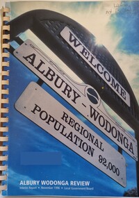
Book - Albury Wodonga Review - Interim Report, Local Govenment Board, 1996
... It features the Welcome ti Albury-Wodonga road sign showing a regional population of 92,000....It features the Welcome ti Albury-Wodonga road sign showing a regional population of 92,000. ...This book is the interim report for the review into the future development of the Albury Wodonga region. It was conducted by the Local Government Board and followed extensive investigation into cross border issues following the abolition of the Albury Wodonga Corporation, The overall recommendation was that Albury Wodonga's best interests would be served by a single-cross border municipality capable of governing the whole city on both sides of the Murray River.A spiral bound report of A4 size created by the Local Government Board. It features the Welcome ti Albury-Wodonga road sign showing a regional population of 92,000.non-fictionThis book is the interim report for the review into the future development of the Albury Wodonga region. It was conducted by the Local Government Board and followed extensive investigation into cross border issues following the abolition of the Albury Wodonga Corporation, The overall recommendation was that Albury Wodonga's best interests would be served by a single-cross border municipality capable of governing the whole city on both sides of the Murray River.albury wodonga development, albury wodonga governance -
 Orbost & District Historical Society
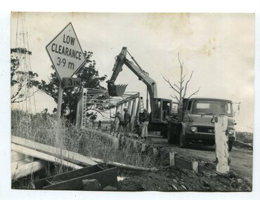
black and white photographs, 1976 - 1977
... In 3246.1 there is a triangular road sign - "LOW CLEARANCE 3.9m"...In 3246.1 there is a triangular road sign - "LOW CLEARANCE 3.9m" black and white photographs Snowy River Mail ...These photographs are of the demolition of the road bridge across the Snowy River at Orbost. This bridge over the Snowy River was opened on July 4 1922. It was constructed in 1922 alongside the previous suspension bridge. Its building was a combined effort of the Victorian Railways and the Country Roads Board at a cost of 35,000 pounds. It was replaced in 1976 by the present bridge after several major floods.This bridge was replaced in 1976 after several major floods. These photographs are pictorial records of its demolition.Four black / white photographs of the demolition of a road bridge across a river. In them can be seen trucks, excavators and workmen. In 3246.1 there is a triangular road sign - "LOW CLEARANCE 3.9m"bridge-demolition orbost-snwoy-river-bridge -
 Musculoskeletal Health Australia (now held by the Glen Eira Historical Society)
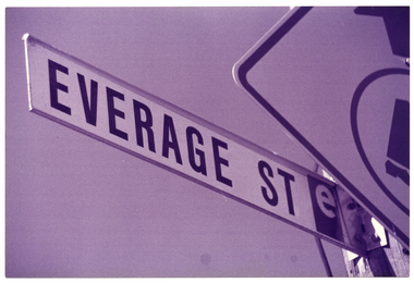
Photograph - Object, March - April 1994
... B&W photo of a street sign name "Everage St". Another road sign, for a pedestrian crossing (partially obscured) is also in the frame. ...The character's surname is a play on words: before she became a dame, Edna was an 'average' housewife who famously hailed from the Melbourne suburb of Moonee Ponds. https://www.victorianplaces.com.au/moonee-ponds arthritis foundation of victoria afv opportunity shop op shop charity shop everage street moonee ponds 1994 B&W photo of a street sign name "Everage St". Another road sign, for a pedestrian crossing (partially obscured) is also in the frame. ...In around March to April 1994, the Arthritis Foundation of Victoria (AFV) opened a second oppportunity shop in Moonee Ponds. This photo depicts a close up photo of the street sign for "Everage Street", taken from a low angle. The street, which runs beside a carpark behind the main shopping strip on Puckle St, was named after internationally renowed Australian satirist Barry Humphries' character, Dame Edna Everage. The character's surname is a play on words: before she became a dame, Edna was an 'average' housewife who famously hailed from the Melbourne suburb of Moonee Ponds. https://www.victorianplaces.com.au/moonee-pondsB&W photo of a street sign name "Everage St". Another road sign, for a pedestrian crossing (partially obscured) is also in the frame. The photo has been taken from a low angle.arthritis foundation of victoria, afv, opportunity shop, op shop, charity shop, everage street, moonee ponds, 1994 -
 Ringwood and District Historical Society
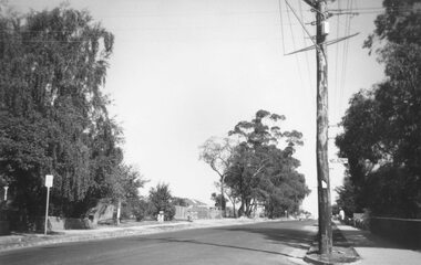
Photograph, Ringwood Street at Nelson Street Ringwood, looking south, early 1960s prior to Eastland development
... Houses either side of road. Road sign on telegraph pole reads, "Nelson St."...Houses either side of road. Road sign on telegraph pole reads, "Nelson St." ...Black and white photograph showing made road. Telegraph pole on right of picture. Tall trees to left of photograph. Houses either side of road. Road sign on telegraph pole reads, "Nelson St."Typed below photograph, "Ringwood St. looking south. Ringwood Reserve to left of row of trees in centre." -
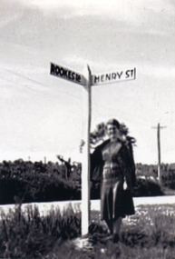 Whitehorse Historical Society Inc.
Photograph, Road signs - No roads
... Black and white photograph of road signs in Rooks Road. Note spelling of Rookes which is incorrect and Henry Street which no longer exists. ...It is presumed that it pointed to a street which lost its identity with the development of the Migrant Hostel Road signs - No roads Photograph Photograph ...Sent to a parishioner at Christ Church Mitcham, by Phyllis Grant who lived at the Migrant Hostel in Mitcham in 1952-54, where her husband did development work under the P.M.G.Black and white photograph of road signs in Rooks Road. Note spelling of Rookes which is incorrect and Henry Street which no longer exists. It is presumed that it pointed to a street which lost its identity with the development of the Migrant Hostelrooks road mitcham -
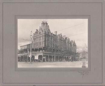 Bendigo Historical Society Inc.
Photograph - SHAMROCK HOTEL COLLECTION:PHOTOGRAPH. SHAMROCK HOTEL
... Bottom right shows two Horse drawn cabs waiting in middle of the road. Signed at bottom right by Photographer, Vincent Kelly, Bendigo....Bottom right shows two Horse drawn cabs waiting in middle of the road. Signed at bottom right by Photographer, Vincent Kelly, Bendigo. ...Photograph. Of the Shamrock Hotel - third building. Post to the left has light at the top. Bottom right shows two Horse drawn cabs waiting in middle of the road. Signed at bottom right by Photographer, Vincent Kelly, Bendigo.Vincent Kellyshamrock hotel, vincent kelly -
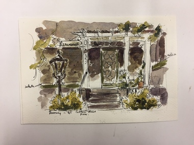 Kew Historical Society Inc
Work on paper, Joy Stewart, Doorway - 45 Cotham Road, Kew, c.1978
... Inscription: "Doorway -, 45 Cotham Road, Kew." Signed lower right: "JStewart"....Joy Stewart died in Cairns in 2018. cotham road (kew) joy stewart Inscription: "Doorway -, 45 Cotham Road, Kew." Signed lower right: "JStewart". Watercolour, pen & Ink on paper by the artist and local historian Joy Stewart of 45 Cotham Road, Kew. ...Sydney Joy (joy) Stewart (1925-2018) was a founding member of the Kew Historical Society, and during the 1970s its secretary. During her residence in Kew, she completed numerous property illustrations on commission. These ranged from preliminary sketches, including architectural details to finished pen & ink and wash illustrations on paper. On moving to Queensland, Joy Stewart donated the remaining property illustrations in her possession to the Kew Historical Society. In 1987-88, she fulfilled a commission by the Society of designs for a series of embroideries completed by residents during the Australian Bicentennial commemorations.Sydney Joy (Joy) Stewart was born in Melbourne 1925. She studied at Swinburne Technical College Art School from 1941-1945, then the National Gallery Art School 1946-1948. Her career included employment positions as a display artist, designer/painter, gallery assistant, and art teacher. Joy relocated to Cairns in 1981. Solo exhibitions in Melbourne and Cairns, including 'Done By Me' at Cairns Regional Gallery in 1999. Group exhibitions at Cairns Regional Gallery, 'The Fish John West Regrets, 1993' and 'Facets of Life' 1994. Joy Stewart died in Cairns in 2018.Watercolour, pen & Ink on paper by the artist and local historian Joy Stewart of 45 Cotham Road, Kew. Inscription: "Doorway -, 45 Cotham Road, Kew." Signed lower right: "JStewart".cotham road (kew), joy stewart -
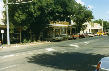 Charlton Golden Grains Museum Inc
Photograph, Pollard, Jenny, High Street Charlton 1989, c.1989
... Colour photograph of the shops at west end and south-side of High Street. 'Donald' on road sign in top left of photo. Large tree in garden bed in front of shops. ...Tippett Ross's Gifts Procter Paterson's Fibre Glass Business Industry Charlton Colour photograph of the shops at west end and south-side of High Street. 'Donald' on road sign in top left of photo. Large tree in garden bed in front of shops. ...Shops at west end and south-side of High Street. Tippett's Clothing & Furniture shop (established 1923), Ross's Gifts (in former Procter's Butcher shop built 1880), Paterson's Fibre Glass Factory, Eddie Harris Mensland.Colour photograph of the shops at west end and south-side of High Street. 'Donald' on road sign in top left of photo. Large tree in garden bed in front of shops. Sign on shop "Ross's Gifts'. Cars parked all along the street.tippett, ross's gifts, procter, paterson's fibre glass, business, industry, charlton -
 Falls Creek Historical Society
Poster - Kangaroo Hoppet 2016
... Beside Kangaroo Hoppet yellow and black Road sign: KANGAROO HOPPET 26 27 August 2016 42 km 21 km 7 km Falls Creek Victoria Australia Below the logos: www.hoppet.com.au ...Beauty Beside Kangaroo Hoppet yellow and black Road sign: KANGAROO HOPPET 26 27 August 2016 42 km 21 km 7 km Falls Creek Victoria Australia Below the logos: www.hoppet.com.au A poster featuring two skiers crossing gentle slopes passing a tree on the right. ...The Kangaroo Hoppet is Australia’s premier long distance cross country ski race, and a member of the Worldloppet series of international cross country ski events. The first race at Falls Creek was held in 1979 under the name of “Australian Birkebeiner”. It was a 21km race with about 80 participants organised by the Birkebeiner Nordic Ski Club of Mount Beauty. The course started and finished at Falls Creek Alpine Resort and took participants out into the Bogong High Plains. After running the event for 10 years, it was decided they should become part of the Worldloppet series of marathon ski races. Representatives from the Birkebeiner Nordic Ski Club and the Australian Ski Federation attended the Worldloppet Annual Meeting in Finland in June 1990 to put the case for the acceptance of an Australian event into the Worldloppet series. Before being admitted, they had to demonstrate that the Birkebeiner Club could run a world class event, so three months later in August 1990 a 42km event named the Australian International Ski Marathon was held at Falls Creek together with a 21km Birkebeiner race and a 7km event called the Birkebeiner Lite. The event was approved by delegates from USA, Norway and Austria, in 1991 Australia became the 12th member of Worldloppet, with the condition that there had to be a name change. After some late night discussion allegedly involving red wine from North East Victoria the main event became the 42km Kangaroo Hoppet, with the minor events being the 21km Australian Birkebeiner, and 7km Joey Hoppet. In the winter of 1991, the first Kangaroo Hoppet was held. It was a great success and has been a regular fixture on the international ski calendar ever since. It features the main 42km event as well as a 21km event and a 7km event. The Hoppet brings the Australian snowfields to an international audience. In 2016 the Men's Winner was Matthew Gelso from USA in a time of 1:53:23.1. The winner of the Women's event was Deedra Irwin of USA in a time of 2:08:15.6. This poster is significant because it documents an event which brings international attention to Falls Creek and the surrounding region.A poster featuring two skiers crossing gentle slopes passing a tree on the right. There is a line of international flags flying overhead and the outline of two kangaroos in the distance. Logos of Worldloppet, AGL, Falls Creek, Alpine Shire Council, Victorian State Government, the Birkebeiner Nordic Ski Club and FIS are across the bottom of the poster.Beside Kangaroo Hoppet yellow and black Road sign: KANGAROO HOPPET 26 27 August 2016 42 km 21 km 7 km Falls Creek Victoria Australia Below the logos: www.hoppet.com.au kangaroo hoppet, worldloppet events, falls creek, mt. beauty -
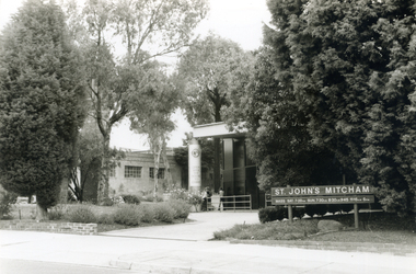 Whitehorse Historical Society Inc.
Photograph, St. Johns Catholic Church, 2000
... John's Catholic Church in Whitehorse Road, featuring sign....John's Catholic Church in Whitehorse Road, featuring sign. St. Johns Catholic Church Photograph Photograph ...Produced as one of a series of 24 prints commissioned by Nunawading & District Historical Society -|Theme: Intersections of Mitcham and Nunawading 2000/2001.|See also Series by P. Simmenauer on the same theme.Black and white photograph - print and negative of St. John's Catholic Church in Whitehorse Road, featuring sign.st. john's catholic church, mitcham, whitehorse road -
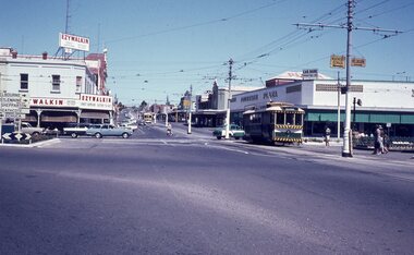 Ballarat Tramway Museum
Slide - 35mm slide/s, early 1960's
... Photo shows 'Ezywalkin' and 'Fountain Plaza' buildings, has large white with black lettering road signs on left. On centre pole in front of tram is smaller road direction signs (yellow with black letters) for Echuca, Heathcote and Melbourne. ...Photo shows 'Ezywalkin' and 'Fountain Plaza' buildings, has large white with black lettering road signs on left. On centre pole in front of tram is smaller road direction signs (yellow with black letters) for Echuca, Heathcote and Melbourne. ...Bendigo Charing Cross, looking east towards railway station, with SEC No. 7 about to depart for Eaglehawk. A Birney tram in background heading for Quarry Hill. Photo shows 'Ezywalkin' and 'Fountain Plaza' buildings, has large white with black lettering road signs on left. On centre pole in front of tram is smaller road direction signs (yellow with black letters) for Echuca, Heathcote and Melbourne. Tram has dash canopy lights, early 1960's.niltramways, trams, bendigo, charing cross, quarry hill, eaglehawk, tram 7 -
 National Vietnam Veterans Museum (NVVM)
Artwork, other - Painting on velvet
... He is holding a road sign hand written 67 HQ69 SIG BR 68. Flags of USA, Vietnam and Korea in background with silhouettes of tanks and soldiers on horizon. ...He is holding a road sign hand written 67 HQ69 SIG BR 68. Flags of USA, Vietnam and Korea in background with silhouettes of tanks and soldiers on horizon. ...Round black velvet disc with caricature of a US Army soldier, "ZERR" on right pocket. He is holding a road sign hand written 67 HQ69 SIG BR 68. Flags of USA, Vietnam and Korea in background with silhouettes of tanks and soldiers on horizon. Rows of barbed wire in foreground. At top: 6-VIETNPM - 6 (in white) On helmet: FAIO (written by hand) On sign: 67 HQ69 SIG BR 68 (in white) disc, painting, velvet, us soldier, caricature -
 Whitehorse Historical Society Inc.
Photograph, Whitehorse Road, Mitcham, 2000
... Featured from L-R shops include Stan Russell Mens Clothing; Top floor Wing Chum Kung Fu Academy (Martial Art); Lower floor: Florist, Bryson Office Supplies, Mitcham Pharmacy and Medical Centre; Road sign - Mitcham Road - Vermont; across intersection - sign for 'Bristol Paints'....Featured from L-R shops include Stan Russell Mens Clothing; Top floor Wing Chum Kung Fu Academy (Martial Art); Lower floor: Florist, Bryson Office Supplies, Mitcham Pharmacy and Medical Centre; Road sign - Mitcham Road - Vermont; across intersection - sign for 'Bristol Paints'. ...Produced as one of a series of 24 prints commissioned by Nunawading & District Historical Society -|Theme: Intersections of Mitcham and Nunawading 2000/2001.|See also Series by P. Simmenauer on the same theme. Black and white photograph - print and negative looking East along North side of Whitehorse Road towards Mitcham Road intersection from corner of Station Street. Featured from L-R shops include Stan Russell Mens Clothing; Top floor Wing Chum Kung Fu Academy (Martial Art); Lower floor: Florist, Bryson Office Supplies, Mitcham Pharmacy and Medical Centre; Road sign - Mitcham Road - Vermont; across intersection - sign for 'Bristol Paints'.whitehorse road, mitcham, stan russell menswear, wing chum kung fu academy, florists, mitcham pharmacy, mitcham medical centre, bristol paints, bryson office supplies -
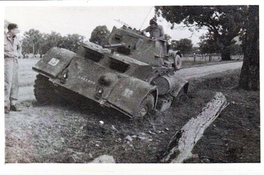 8th/13th Victorian Mounted Rifles Regimental Collection
Photograph
... Black and white photograph of Armoured Car bogged on side of road. Tactical sign of 2nd Armoured Brigade on right mudguard....Black and white photograph of Armoured Car bogged on side of road. Tactical sign of 2nd Armoured Brigade on right mudguard. ...Collection of photographs showing early evolution of an armoured regiment of the Citizen Forces as it progressed from WWII equipment and uniforms to post-war equipment and uniforms. Silver regimental hat badges are worn in place of Rising Sun badge.Unique collection of photographs showing the first years of an armoured regiment of the post-Second World War era Citizen Military Forces showing equipment, uniforms, training and social activity and some personalities.Black and white photograph of Armoured Car bogged on side of road. Tactical sign of 2nd Armoured Brigade on right mudguard." Staghound Armoured car 1956' Exercise in Chiltern/ Rutherglen area." -
 Greensborough Historical Society
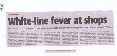
Newspaper Clipping, Diamond Valley Leader, White line fever at Were Street Shops, 23/08/2017
... When motorists completely ignore a road sign, it's time to hammer the message home. ...Greensborough Historical Society 34A Glenauburn Road Lower Plenty Lower Plenty melbourne When motorists completely ignore a road sign, it's time to hammer the message home. ...When motorists completely ignore a road sign, it's time to hammer the message home. Double white lines in Were Street Montmorency are a deterrent to crossing the road to a carpark on the other side.News article 1 page, black text.banyule city council, road rules, were street montmorency, car parking -
![Sign, Shire of Eltham, St Faiths Road, Shire of Eltham [street sign], 1970c](/media/collectors/4f729f5697f83e03086015b8/items/67db7068b13536720ddd1c08/item-media/67f21867e76666667ba84bc9/item-fit-380x285.jpg?cb=6) Greensborough Historical Society
Greensborough Historical SocietySign, Shire of Eltham, St Faiths Road, Shire of Eltham [street sign], 1970c
... St Faiths Road, Shire of Eltham [street sign]...sign...st faiths road montmorency...Road sign pre 1994 of St Faiths Road, Montmorency, formerly in the Shire of Eltham. ...Greensborough Historical Society 34A Glenauburn Road Lower Plenty Lower Plenty melbourne Road sign pre 1994 of St Faiths Road, Montmorency, formerly in the Shire of Eltham. ...Road sign pre 1994 of St Faiths Road, Montmorency, formerly in the Shire of Eltham. Following the redistribution of local government areas in 1994, St Faiths Road was allocated to the City of Banyule.Double Sided Metal sign painted yellow with green writing and Shire of Eltham Logo and Nameshire of eltham, sign, st faiths road montmorency -
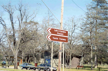 Ballarat Tramway Museum
Photograph - Colour Photograph/s - set of 2, Warren Doubleday, 13/09/2003 12:00:00 AM
... Set of two colour photographs of the then new road signs indicating the BTM using the words "Tourist Tramway" in the central median strip of Sturt St. ...Set of two colour photographs of the then new road signs indicating the BTM using the words "Tourist Tramway" in the central median strip of Sturt St. ...Set of two colour photographs of the then new road signs indicating the BTM using the words "Tourist Tramway" in the central median strip of Sturt St. West, or Western Highway at the intersection with Hamilton Ave. Photos taken by Warren Doubleday on 13.09.2002. Printed on Agfa Paper. 2604.1 - Taken from the western side 2604.2 - ditto, but further back. On rear of each photo in brown felt tip pen, the words "New Signage at Highway".btm, hamilton ave, western highway, sturt st west