Showing 331 items matching "northern area"
-
 NMIT (Northern Melbourne Institute of TAFE)
Journal: Northern contact, Northern Area Consultative Committee 1998-2007
... Journal: Northern contact, Northern Area Consultative Committee 1998-2007...Journal: Northern contact, Northern Area Consultative Committee 1998-2007...Northern Area Consultative Committee...NMIT (Northern Melbourne Institute of TAFE) Northern Area Consultative Committee Journals A4 size journal published since 1998. ...A4 size journal published since 1998. Years held 1998-2007 (incomplete). Dealt with 'Issues related to vocational skills, business growth and development, vocational education and training, school to work transition and demonstration and achievement of best practice in business, industry and education in the north of Melbourne.' northern area consultative committee, journals -
Bendigo Historical Society Inc.
Document - Forests Commission of Victoria Northern Area Fire Protection Policy, Statement, Future Bush Fire Policy, Plan for Fire Control, 1938-1939
... Forests Commission of Victoria Northern Area Fire Protection Policy, Statement, Future Bush Fire Policy, Plan for Fire Control....Four Files Forests Commission of Victoria Northern Area Report on the 1938-39 Fire Season; and the Fire Protection Policy in Respect of Field activities Prior to the Incidence of the 1939 Fires. ...Document Forests Commission of Victoria Northern Area Fire Protection Policy, Statement, Future Bush Fire Policy, Plan for Fire Control. ...Fanned by powerful winds, the Black Friday fires (13 January 1939) swept rapidly across large areas of Victoria, causing widespread destruction. Flames leaped large distances, and giant trees were blown out of the ground by fierce winds. Large pieces of burning bark (embers) were carried for kilometres, starting new fires in places that had not previously been affected by flames. Almost two million hectares burned across the state. Large areas of state forest, containing giant stands of Mountain Ash and other valuable timbers, were destroyed. As a result, approximately 575,000 hectares of reserved forest and 780,000 hectares of Crown land burned.Four Files Forests Commission of Victoria Northern Area Report on the 1938-39 Fire Season; and the Fire Protection Policy in Respect of Field activities Prior to the Incidence of the 1939 Fires. history, bendigo, forests commision of victoria, 1939 bush fires -
 Melbourne Tram Museum
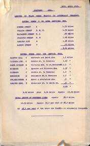
Document - Report, Tramway Board, "Northern Area - Lengths of track where traffic is abnormally frequent", 30/04/1919 12:00:00 AM
... "Northern Area - Lengths of track where traffic is abnormally frequent"...Report - single sheet, typed, titled, "Northern Area - Lengths of track where traffic is abnormally frequent", listing: 1 - Routes where 2 or more services run - giving the length in miles. 2 - route where only one service runs. ...Two copies held. "Northern Area - Lengths of track where traffic is abnormally frequent" Document Report Tramway Board ...Report - single sheet, typed, titled, "Northern Area - Lengths of track where traffic is abnormally frequent", listing: 1 - Routes where 2 or more services run - giving the length in miles. 2 - route where only one service runs. Gives an analysis of the results. Two copies held.trams, tramways, cable trams, track, services -
Ballarat Tramway Museum
Sign - Sign - Destination Blinds, Trains, Vuictorian Rail Suburban Train Destination Blind in miniature - North and East stations, Melbourne
... ...northern area...Place names listed are Lalor, Epping, South Morang, Heidelberg, Macleod, Greensborough, Eltham, East Doncaster, Princes Bridge, City Circle, City Loop, Flinders Street, Spencer Street, Camberwell, Box Hill, Ringwood, Croydon, Lilydale, Coldstream, Upper Ferntree Gully, Belgrave, Alamein, Darling, Glen Waverley. train destination blind northern area eastern area lalor epping south morang macleod greensborough eltham hurstbridge east doncaster princes bridge city circle city loop flinders street spencer street camberwell box hill ringwood croydon lilydale coldstream upper ferntree gully belgrave alamein darling glen waverley Station names List of station names on black paper written in white Vuictorian Rail Suburban Train Destination Blind in miniature - North and East stations, Melbourne Sign Sign - Destination Blinds, Trains ...Ron Bridger was an avid collector of items related to transport, predominately Trams. These items include newspaper cuttings, pamphlets, reports, timetables, fares prices plus special items relating to events. Items from Melbourne and regional Victoria, interstate - Adelaide and Sydney, plus overseas, make up this collection. A suburban train destination blind in miniature. Place names indicate the northern and eastern suburbs that the train travels to. Place names listed are Lalor, Epping, South Morang, Heidelberg, Macleod, Greensborough, Eltham, East Doncaster, Princes Bridge, City Circle, City Loop, Flinders Street, Spencer Street, Camberwell, Box Hill, Ringwood, Croydon, Lilydale, Coldstream, Upper Ferntree Gully, Belgrave, Alamein, Darling, Glen Waverley. List of station names on black paper written in whiteStation namestrain destination blind, northern area, eastern area, lalor, epping, south morang, macleod, greensborough, eltham, hurstbridge, east doncaster, princes bridge, city circle, city loop, flinders street, spencer street, camberwell, box hill, ringwood, croydon, lilydale, coldstream, upper ferntree gully, belgrave, alamein, darling, glen waverley -
 Emerald Museum & Nobelius Heritage Park
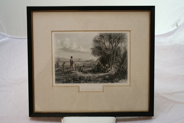
Relief prints, Thomas Baines et al, An Explorer's Camp, Circa 1875
... Thomas Baines joined Augustus Gregory as official artist and storekeeper, in the expedition across northern Australia between 1855-1857 sponsored by the Royal Geographical Society to evaluate the northern area of Australia for suitability as a colonial settlement. ...Thomas Baines joined Augustus Gregory as official artist and storekeeper, in the expedition across northern Australia between 1855-1857 sponsored by the Royal Geographical Society to evaluate the northern area of Australia for suitability as a colonial settlement. ...Thomas Baines joined Augustus Gregory as official artist and storekeeper, in the expedition across northern Australia between 1855-1857 sponsored by the Royal Geographical Society to evaluate the northern area of Australia for suitability as a colonial settlement. ...From 'Australia' by Edwin Carton Booth. Thomas Baines joined Augustus Gregory as official artist and storekeeper, in the expedition across northern Australia between 1855-1857 sponsored by the Royal Geographical Society to evaluate the northern area of Australia for suitability as a colonial settlement. The Baines River was named after him.The item is socially and artistically significant as it is a very early image of Northern Australia.Framed black and white etching depicting a cap site located near the ocean.Artist T. Baines - J.J. Crew. From 'Australia' by Edwin Carton Booth. Thomas Baines joined Augustus Gregory as official artist and storekeeper, in the expedition across northern Australia between 1855-1857 sponsored by the Royal Geographical Society to evaluate the northern area of Australia for suitability as a colonial settlement. The Baines River was named after him.print, baines -
 National Vietnam Veterans Museum (NVVM)
Photograph, Gibbons, Denis, The Imperial Palace Ceiling
... A coloured photograph of Ceiling decorations in the receiving foyer area of the Imperial Palace at Hue, in the Northern area of South Vietnam. The Palace was heavily damaged during the Tet Offensive of January to March 1968. the richness and beauty of the palace was completely scared....Photograph Imperial Palace Hue Tet Offensive 1968 Gibbons Collection Catalogue Denis Gibbons A coloured photograph of Ceiling decorations in the receiving foyer area of the Imperial Palace at Hue, in the Northern area of South Vietnam. The Palace was heavily damaged during the Tet Offensive of January to March 1968. the richness and beauty of the palace was completely scared. ...Denis Gibbons (1937 – 2011) Trained with the Australian Army, before travelling to Vietnam in January 1966, Denis stayed with the 1st Australian Task Force in Nui Dat working as a photographer. For almost five years Gibbons toured with nine Australian infantry battalions, posting compelling war images from within many combat zones before being flown out in late November 1970 after sustaining injuries. The images held within the National Vietnam Veterans Museum make up the Gibbons Collection. A coloured photograph of Ceiling decorations in the receiving foyer area of the Imperial Palace at Hue, in the Northern area of South Vietnam. The Palace was heavily damaged during the Tet Offensive of January to March 1968. the richness and beauty of the palace was completely scared.photograph, imperial palace, hue, tet offensive, 1968, gibbons collection catalogue, denis gibbons -
 Greensborough Historical Society
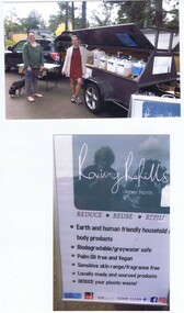
Photograph - Photographs, Rosie Bray, Roving Refills at Greenhills Neighbourhood house, 2021c
... Roving Refills produce and sell their household and body products in the inner northern area of Melbourne....Roving Refills produce and sell their household and body products in the inner northern area of Melbourne. skin care products cleaning products roving refills greenhills neighbourhood house Two colour photographs with order information card Roving Refills at Greenhills Neighbourhood house Photograph Photographs Rosie Bray ...Photographs of publicity and market sales trailer of "Roving Refills", an occasional service at Greenhills Neighbourhood House. Roving Refills produce and sell their household and body products in the inner northern area of Melbourne.Two colour photographs with order information cardskin care products, cleaning products, roving refills, greenhills neighbourhood house -
 Melbourne Tram Museum
Document - Report, Tramway Board, "Percentage of full life worn off the various type of large sheeves pulleys at the power houses and termini and the various types of pulleys and their spindles in use along the track", 10/10/1917 12:00:00 AM
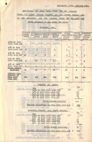
... Report - typed four pages - two copies - brass clipped together - titled "Percentage of full life worn off the various type of large sheeves pulleys at the power houses and termini and the various types of pulleys and their spindles in use along the track", listing the details for each engine or power house in the Northern Area - Fitzroy, Nicholson St, Richmond, Brunswick, North Melbourne, North Carlton and Johnston St engine houses. ...Melbourne Tram Museum 8 Wallen Road Hawthorn melbourne Trams tramways Cable Trams Track Engine Houses Cables Equipment Report - typed four pages - two copies - brass clipped together - titled "Percentage of full life worn off the various type of large sheeves pulleys at the power houses and termini and the various types of pulleys and their spindles in use along the track", listing the details for each engine or power house in the Northern Area - Fitzroy, Nicholson St, Richmond, Brunswick, North Melbourne, North Carlton and Johnston St engine houses. ...Report - typed four pages - two copies - brass clipped together - titled "Percentage of full life worn off the various type of large sheeves pulleys at the power houses and termini and the various types of pulleys and their spindles in use along the track", listing the details for each engine or power house in the Northern Area - Fitzroy, Nicholson St, Richmond, Brunswick, North Melbourne, North Carlton and Johnston St engine houses. Dated 10/10/1917trams, tramways, cable trams, track, engine houses, cables, equipment -
 Melbourne Tram Museum
Document - Drawing, Public Transport Corporation (PTC), "PTC Preston Workshops fire services", 12/1997
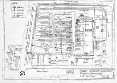
... Shows track work changes in the northern area of the workshops. Dated 16/12/1997. ...Shows track work changes in the northern area of the workshops. Dated 16/12/1997. ...A3 size drawing titled "PTC Preston Workshops fire services" showing locations of hydrants, mains, alarms, valves, and dangerous goods locations. Includes the Thornbury car shed and fibreglass workshop. Shows track work changes in the northern area of the workshops. Dated 16/12/1997. Original drawing dated 20 May 1996 for the Public Transport Corporation.Yields information about the layout of Preston Workshops in Dec. 1997,A4 sheet, marked up in blue ink for changes to track layout.Dated 16/12/1997 in ink.tramways, preston workshops, trackwork, floor plans, track plans -
 Bendigo Historical Society Inc.
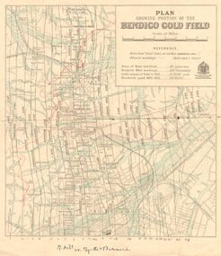
Map - DEPARTMENT OF MINES VICTORIA : PLAN SHOWING PORTION OF THE BENDIGO GOLD FIELD
... J. Tyler 1937 Northern Area. (He was a teacher at Bendigo High - see donation notes). ...J. Tyler 1937 Northern Area. (He was a teacher at Bendigo High - see donation notes). ...Department of Mines Victoria. Plan showing portion of the Bendigo Gold Field. On the back is written, in ink, J. J. Tyler 1937 Northern Area. (He was a teacher at Bendigo High - see donation notes). Across the bottom of the map is written ' M. Hill cr. Myrtle & Barnard' .The named reef lines have been numbered with ink across the bottom of the map. The gullies have been coloured with green pencil and a red pencil line is drawn through the western side of the map. Additional information: anticlinal axial lines at surface, alluvial workings, shaft sites, area of Main Goldfield, Deepest mine workings, Gold output of field to 1935, and Dividends paid 1870 - 1935.bendigo, gold mining, bendigo gold field. gold mining. tyler, j. j. -
 Wodonga & District Historical Society Inc
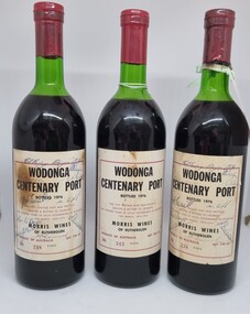
Memorabilia - Bottles - Wodonga Centenary Port, Morris Wines of Rutherglen, 1976
... Wodonga Shire was created in 1876 when the colonial government agreed to ratepayers' petitions to have their northern area severed from the Yackandandah Shire and form a new municipality. ...Wodonga Shire was created in 1876 when the colonial government agreed to ratepayers' petitions to have their northern area severed from the Yackandandah Shire and form a new municipality. ...This bottling of Wodonga Centenary Port was provided by Morris Wines of Rutherglen to celebrate the Centenary of local government in Wodonga. Wodonga Shire was created in 1876 when the colonial government agreed to ratepayers' petitions to have their northern area severed from the Yackandandah Shire and form a new municipality. In 1976 celebrations were held to mark this milestone. These bottles were donated to the Wodonga & District Historical by Jenny Brown nee Terrill daughter of former Wodonga Shire President, Councillor J. A. Terrill. These bottles of the Wodonga Centenary Port were signed by all of the councillors serving in 1976.This artefact represents the celebrations for the centenary of local government in Wodonga.3 bottles of port produced by Morris Wines of Rutherglen. This bottling celebrated the centenary of local government in Wodonga. The label is on beige paper with a maroon outline and black text. These bottle have been autographed and bear the numbers 238. 248 and 343.On Label: "WODONGA / CENTENARY PORT/BOTTLED 1976/ THIS 1975 PORT WAS SPECIALLY/ SELECTED & BOTTLED TO CELEBRATE / ONE HUNDRED YEARS OF LOCAL GOVERNMENT IN WODONGA/ 10th MARCH 1876 - 1976/ MORRIS WINES / OF RUTHERGLEN/ PRODUCT OF AUSTRALIA NET 738 ml/ NO 343 E2314wodonga shire council, wodonga local government, wodonga local government centenary -
 Bendigo Military Museum
Uniform - DRESS UNIFORM, RAAF
... During WW2 from 1941 he was explosives Inspecting Officer at Northern Area 5 then to Explosive Inspecting Officer for the whole RAAF in the S/W Pacific. ...During WW2 from 1941 he was explosives Inspecting Officer at Northern Area 5 then to Explosive Inspecting Officer for the whole RAAF in the S/W Pacific. ...The uniform belonged to Wing Commander "Leonard Bacon", born 11 June 1906. He enlisted in the RAAF on 31 May 1926 No. 03305 with the rank AC.1. In 9 postings in Vic, QLD and WA he rose through 11 ranks to Sgt Maj Class 2 by 1940. He was commissioned as Flying Officer on 1.8.1940. He rose through the ranks to be Wing Commander on 1.7.1951. During WW2 from 1941 he was explosives Inspecting Officer at Northern Area 5 then to Explosive Inspecting Officer for the whole RAAF in the S/W Pacific. This role took him to some 21 places in the North from Townsville - Darwin to across the islands many several times. Leonard was awarded a "Mention in Despatches" on Morotai in 1945. Post WW2 in 1950 Leonard was appointed Chief Inspector of explosives in the RAAF, one of these roles was the supervision of the disposal of large quantities of War Stock. On 13.6.1958 he was recommended for an “OBE” which he received in the 1959 New Years Honors List. Leonard retired from the RAAF on 11.6.1960 after 34 years. This is a very brief record of his service documents.Dark Blue Service Dress Uniform comprising of jacket (.1) Pants (.2) gold buttons with RAAF emblems. Ribbons on the coat are as follows; Left to Right: OBE, 1939-45 Star, Pacific Star, British War Medal with clasp "MID". Australian Service medal, Long Service and Good Conduct medal. Jacket has black inside lining with belt connected to back. Three stripes of Wing Commander rank on the sleeves. Size "M".raaf, uniform, leonard bacon -
 The Beechworth Burke Museum
Animal specimen - White-bellied Cuckooshrike, Trustees of the Australian Museum, 1860-1880
... In Australia, it is distributed widely, occurring in tropical northern areas as well as in the eastern parts of the country, including northern Western Australia, the Northern Territory, Queensland, New South Wales, Victoria, and southeastern South Australia. ...In Australia, it is distributed widely, occurring in tropical northern areas as well as in the eastern parts of the country, including northern Western Australia, the Northern Territory, Queensland, New South Wales, Victoria, and southeastern South Australia. ...The white-bellied cuckooshrike inhabits regions across Australia, Indonesia, Papua New Guinea, and the Solomon Islands. In Australia, it is distributed widely, occurring in tropical northern areas as well as in the eastern parts of the country, including northern Western Australia, the Northern Territory, Queensland, New South Wales, Victoria, and southeastern South Australia. The species is prevalent throughout Papua New Guinea and the Solomon Islands, but less frequently observed in Indonesia. Within Indonesia, it is most commonly found in the northern Moluccas, with occasional sightings in Eastern Wallacea. This specimen was originally identified as a young Black-Cuckoo-shrike and catalogued as such in the Burke Museum original catalogue. Analysis conducted as part of a conservation treatment in 2024 reclassified the specimen as a white-bellied cuckooshrike. This specimen is part of a collection of almost 200 animal specimens that were originally acquired as skins from various institutions across Australia, including the Australian Museum in Sydney and the National Museum of Victoria (known as Museums Victoria since 1983), as well as individuals such as amateur anthropologist Reynell Eveleigh Johns between 1860-1880. These skins were then mounted by members of the Burke Museum Committee and put-on display in the formal space of the Museum’s original exhibition hall where they continue to be on display. This display of taxidermy mounts initially served to instruct visitors to the Burke Museum of the natural world around them, today it serves as an insight into the collecting habits of the 19th century.This specimen is part of a significant and rare taxidermy mount collection in the Burke Museum. This collection is scientifically and culturally important for reminding us of how science continues to shape our understanding of the modern world. They demonstrate a capacity to hold evidence of how Australia’s fauna history existed in the past and are potentially important for future environmental research. This collection continues to be on display in the Museum and has become a key part to interpreting the collecting habits of the 19th century.This specimen is a young White-bellied cuckooshrike which stands perched on a wooden mount. It has pale grey colouring which is darker on the rear. The wings are tipped with grey-brown feathers and the same colour feathers also appear on the bird's tale. The specimen has dark limbs and bill and this specimen is provided with two glass eyes which are dark in colouring. The bird has a more creamy pale grey on the throat and stomach. It has a black facial mask which is restricted to an eye stripe. 21a / Black Faced Graculus / See catalogue page 11taxidermy mount, taxidermy, animalia, burke museum, beechworth, australian museum, skin, reynell eveleigh johns, bird, cuckoo, shrike, common birds, australian birds, australian bird, white-bellied cuckooshrike -
 Eltham District Historical Society Inc
Film - Video (VHS), Phil Burke et al, Shire of Eltham Grants Commsission Submission (Series 69, Item 7), 1993
... The Shire covers over 27,000 hectares with a population in excess of 45,000 residents, more than 70% living in the southern 10% of the Shire in suburbs of Eltham, Montmorency, Lower Plenty and Research. 85% of the Shire in the more sparsely populated northern area which is covered by the Green Wedge. ...The Shire covers over 27,000 hectares with a population in excess of 45,000 residents, more than 70% living in the southern 10% of the Shire in suburbs of Eltham, Montmorency, Lower Plenty and Research. 85% of the Shire in the more sparsely populated northern area which is covered by the Green Wedge. ...Shire of Eltham Archives: Series 69, Item 7 Opens with aerial views of the Shire, 85% of the shire covered by the Green wedge principal. Discusses the obligations required of the Shire to maintain the Green Wedge. The Shire covers over 27,000 hectares with a population in excess of 45,000 residents, more than 70% living in the southern 10% of the Shire in suburbs of Eltham, Montmorency, Lower Plenty and Research. 85% of the Shire in the more sparsely populated northern area which is covered by the Green Wedge. Council is committed to providing a parity of services to all residents such as garbage collection and maintenance of roads. Views of rubbish collection trucks in Montmorency. It is emphasised that the cost of these services in highly populated areas is relatively low whereas in the sparsely populated Green Wedge areas, considerable. There are hundreds of kilometres of roads throughout the Shire, many unmade and maintenance is high to check overhanging trees and erosion especially on the steep hills is expensive and disproportionate to servicing the population in the dense urban areas. Shows views of hilly gravel roads and graders at work maintaining them. Shows scenes of assessing planning applications in these rural areas which takes significantly more time as well as other services provided such as Meals on Wheels, building permits, Ranger services. Provision of recreational facilities in hilly areas requires the acquisition of expensive river flats (views of cricket ground surrounded by hills) and where not possible, costly earthmoving required. Also, views highlighting extensive tracks of natural habitat home to significant bird, animal and plant life. Shire emphasises its commitment highlighted by the Eltham Copper Butterfly which the Shire maintains small pockets of bushland to ensure its survival at significant expense (views of Pauline Toner Copper Butterfly Reserve.) Short interview with Pat Vaughan, Environmental Officer for the Shire discussing the Eltham Copper Butterfly who also mentions many other species in the Shire of high significance from bats to mammals to plants as well as the importance of the Green Wedge to Melbourne – the lungs of Melbourne - and ensuring the protection of very important habitat which requires a great deal of planning and management to look after. Views of Wingrove Park to emphasise this maintenance by machinery in some areas is too damaging and introduced species, etc must be removed by hand. Balancing the services and facilities expected by the community with the needs of the environment requires careful planning demands requires careful planning and the principals of the Green Wedge require constant attention in the face of growing need for housing. Director of Planning & Environment, Richard Allen advises there are approximately 1,300 planning permits and development applications each year ranging from simple subdivision, boundary realignments to further complicated non-urban developments for agricultural pursuits and the level of expertise required from architectural and engineering to land degradation, flora and fauna. Video finishes with aerial views and parklands, streetscapes and rural areas. VHS Video cassette Converted to MP4 file format 00:07:39; 89MBshire of eltham, video recording, shire of eltham archives, eltham shire council, eltham, building permits, cricket ground, development applications, eltham copper butterfly, garbage collection, graders, green wedge, lower plenty, meals on wheels, montmorency, pat vaughan, pauline toner reserve, planning applications, planning permits, ranger services, recreational facilities, research, richard allen, roads, rural areas, wingrove park, victoria grants commission -
 Bendigo Historical Society Inc.
Book - BENDIGO SALEYARDS COLLECTION: BENDIGO SALEYARDS RELOCATION STUDY - PLANNING REPORT AND ENVIRONMENT
... Drawings in Fig 1 Existing Bendigo Saleyards and Surrounding Land Uses, Fig 2 Catchment Area for Bendigo Saleyards 1983, Fig 4.1 Estimated Sheep Populatiuon in Catchment Area 1976 - 77 to 1981 - 82, Fig 4.2 Estimated Cattle Population in Catchment area 1976 -77 to 1981 -82, Fig 3 Possible Saleyard Relocation Areas, Fig 4, Directions from which access to possible Saleyard Locations would be obtained - Estimated percentage of sheep to cattle stock, Fig 5 Possible Saleyard Locations - Northern Area, Fig 6 Possible Locations of Saleyards - Inner West, Fig 7 Possible Locations of Saleyards - Outer West. ...Drawings in Fig 1 Existing Bendigo Saleyards and Surrounding Land Uses, Fig 2 Catchment Area for Bendigo Saleyards 1983, Fig 4.1 Estimated Sheep Populatiuon in Catchment Area 1976 - 77 to 1981 - 82, Fig 4.2 Estimated Cattle Population in Catchment area 1976 -77 to 1981 -82, Fig 3 Possible Saleyard Relocation Areas, Fig 4, Directions from which access to possible Saleyard Locations would be obtained - Estimated percentage of sheep to cattle stock, Fig 5 Possible Saleyard Locations - Northern Area, Fig 6 Possible Locations of Saleyards - Inner West, Fig 7 Possible Locations of Saleyards - Outer West. ...Bendigo Saleyards Relocation Study - Planning Report and Environment Effects Statement for the City of Bendigo by A E Huefner & Associates Pty Ltd in association with Meldrum Burrows & Partners. Book has a light brown cover with black plastic binder spine. Green and yellow pages separate some sections. The front cover has a sketch of a stock transport with a pig, sheep and cattle behind gates. Contents include: Introduction, Summary, Recapitulation on the Feasibility Report which includes The Need for Action, the Site and Existing Uses Adjacent to the Site, The Proposal which includes Concept, Project Description, Components, Siting of Facilities, Land Clearing, Earthworks, Darainage, Buildings and Structures, Roads and Pavements, Services, Landscaping, Soil Profile and Construction Programme. Invironmental Effects which include Visual Impact Dust, Odours, Effluent, Effluent Treatment System, Traffic, Artificial Lighting, Noise, Operational Failures and Nature Conservation Effects. Statutory Planning Considerations which includes Zoning Controls and Suggested Procedure for Initiating I.D.O. Amendment. Appendices are: A.- Copy of Tit;e, B - Soil Investigation, C - Acoustic Assessment and D - Suggested Draft Amendment to Shire of Marong I.D.O. Contains a photo of the area - View of the Site, looking South and a number of drawings. Copies of various Council Reports referring to the Saleyards Relocation Project. It has a bright yellow cover and a hard plastic type spine. Mentioned in the reports is the cost to bring the old saleyards up to standard and list of improvements. Reports are as at 16th July, 1984. Mustard coloured book with plastic spine titled Bendigo Saleyards Relocation Study Feasibility Report by Meldrum Burrows & Partners in association with A E Huefner & Associates Pty Ltd and Acil Australia Pty Ltd dated September, 1983. Items mentioned are: Introduction, Summary, Background, Role in Livestock Marketing for the Bendigo Saleyards (Acil Australia Pty. Ltd., Saleyard Relocation: Strategic Considerations, Financial Implications and Conclusion. Appendix 1: Estimation of Livestock Population in Catchment Area. Drawings in Fig 1 Existing Bendigo Saleyards and Surrounding Land Uses, Fig 2 Catchment Area for Bendigo Saleyards 1983, Fig 4.1 Estimated Sheep Populatiuon in Catchment Area 1976 - 77 to 1981 - 82, Fig 4.2 Estimated Cattle Population in Catchment area 1976 -77 to 1981 -82, Fig 3 Possible Saleyard Relocation Areas, Fig 4, Directions from which access to possible Saleyard Locations would be obtained - Estimated percentage of sheep to cattle stock, Fig 5 Possible Saleyard Locations - Northern Area, Fig 6 Possible Locations of Saleyards - Inner West, Fig 7 Possible Locations of Saleyards - Outer West. Considerations were made as to renovate the existing saleyards or to move them elsewhere. Effluent, transport and stock movement, and condition of the yards were a problem.bendigo, council, cattle markets, bendigo saleyards collection - bendigo saleyards relocation study - planning report and environment effects statement, a e huefner & associates pty ltd, meldrum burrows & partners, city of bendigo, state electricity commission, mal styles, bendigo college of advanced education, n j fieldew, pryce goodale & duncan pty ltd, p b swift, shire of marong -
NMIT (Northern Melbourne Institute of TAFE)
Book: Melbourne’s North – the new knowledge economy Melbourne’s North – the new knowledge economy 2009
... Melbourne’s North – the new knowledge economy is a study commissioned by NORTH Link and the Northern Metropolitan Melbourne Area Consultative Sub-Committee with seed funding from the Victorian Government Department of Innovation, Industry and Regional Development and matching funding from industry, education and local government in Melbourne’s North. ...NMIT (Northern Melbourne Institute of TAFE) Northern Melbourne region NMIT Melbourne’s North – the new knowledge economy is a study commissioned by NORTH Link and the Northern Metropolitan Melbourne Area Consultative Sub-Committee with seed funding from the Victorian Government Department of Innovation, Industry and Regional Development and matching funding from industry, education and local government in Melbourne’s North. ...Melbourne’s North – the new knowledge economy is a study commissioned by NORTH Link and the Northern Metropolitan Melbourne Area Consultative Sub-Committee with seed funding from the Victorian Government Department of Innovation, Industry and Regional Development and matching funding from industry, education and local government in Melbourne’s North. It was prepared by National Institute of Economic and Industry Research. The report provides a detailed analysis of the Melbourne’s North regional economy and builds on the previous report, Growing Melbourne’s North – developing an integrated economy. It concludes that the region can achieve significant economic and social benefits if stakeholders share resources and cooperate across local government boundaries to form a discrete economic zone. The report includes recommendations and benchmarks that will support growth and quality employment outcomes for the region into the future as it undergoes the transition into a knowledge economy. Consultants National Institute of Economic and Industry Research (NIEIR), Carmine Consulting ISBN 978-0-9803994-4-3 northern melbourne region, nmit -
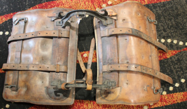 Dandenong/Cranbourne RSL Sub Branch
Memorabilia - Pack Saddle
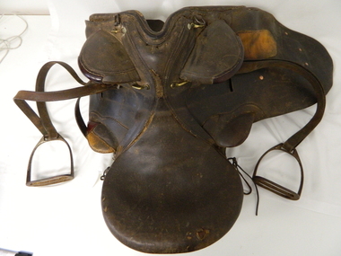
... During the Second World War pack animals were routinely used by patrols, and larger units such as Norforce, in remote areas of northern Australia. The saddle shown here has two separate girths, which crossed under the animal's belly. ...During the Second World War pack animals were routinely used by patrols, and larger units such as Norforce, in remote areas of northern Australia. The saddle shown here has two separate girths, which crossed under the animal's belly. ...Believed to have been made 1939/43. In 1904 the British Army adopted a new General Service (GS) pack saddle with an adjustable tree, known as the Mark V pack saddle. The main innovation was the adjustable tree created by having the front and back steel arches jointed to the wooden sidebars, which allowed them to turn to adjust to the size of the back of whatever animal carried the saddle, from the largest horse to the smallest donkey, and eliminated the need to manufacture saddles in different sizes. The saddle could be adapted, by the addition of hanging bars, or universal slats, to carry a wide variety of stores, tools and equipment, and also wounded men. The GS pack saddle was used in both world wars by both the British and Australian armies. The use of pack saddles was especially important in the campaign in Palestine during the First World War where wheeled transport was often not an option. Each machine gun carried by light horse units was transported on a pack saddle, and was accompanied by a second pack animal carrying spare ammunition. During the Second World War pack animals were routinely used by patrols, and larger units such as Norforce, in remote areas of northern Australia. The saddle shown here has two separate girths, which crossed under the animal's belly. Most later versions of the saddle used a shorter single girth buckled to a 'V' attachment, which was in turn buckled to the sidebars. Use of the 'V' attachment gave greater strength and stability to the saddle, and decreased 'rocking' of the load. -
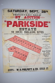 Warrnambool and District Historical Society Inc.
Work on paper - Original Document, H J Paynter, Advertisement "Parkside"Estate subdivision, Circa 1935
... This sheet denotes an auction of land which is situated close to Albert Park on the northern part of Warrnambool. The area is complete now with homes which are a mixture of brick and concrete faced houses. ...Warrnambool and District Historical Society Inc. 2 Gilles Street (south of Merri St) Warrnambool great-ocean-road This sheet denotes an auction of land which is situated close to Albert Park on the northern part of Warrnambool. The area is complete now with homes which are a mixture of brick and concrete faced houses. ...This sheet denotes an auction of land which is situated close to Albert Park on the northern part of Warrnambool. The area is complete now with homes which are a mixture of brick and concrete faced houses. The agent W H Philpott was operating in Warrnambool from the 1930's though to 1950'sThis item has local interest and significance as it records the sale of Warrnambool land.Large white paper sheet with black and red text. The auction details are at the top and down the righthand side with a map of the available blocks are coloured red and outlined in black.Parkside estate, W H Philpott & Co Kepler St , R V Philpott auctioneer,Solicitors J S Tait & son. Cramer Street, Nelson Street McConnell Street.warrnambool, mcconnell street warrnambool -
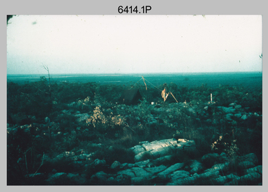 Bendigo Military Museum
Photograph - Royal Australian Survey Corps Surveyors in the Field – Northern Territory and Queensland, 1959 – 1960
... Northern Territory (NT) and Queensland (QLD) in 1959 – 1960. The photographs were printed on photographic paper and are part of the Army Survey Regiment’s Collection. The photographs were scanned at 300 dpi. .1) - Photo, colour, 1959. Tony Slattery occupying a Laplace survey station on a hill in the Mount Young area...Northern Territory (NT) and Queensland (QLD) in 1959 – 1960. The photographs were printed on photographic paper and are part of the Army Survey Regiment’s Collection. The photographs were scanned at 300 dpi. .1) - Photo, colour, 1959. Tony Slattery occupying a Laplace survey station on a hill in the Mount Young area ...This is a set of 10 photographs of surveyors and support staff in the field undertaking duties in the Northern Territory and North Queensland in 1959 – 1960. The surveyors were employed in the establishment of mapping and geodetic control. In this era surveyors used theodolites to observe horizontal and vertical angles and tellurometers to measure base line distances between survey stations. Laplace survey observations seen in Photo .1P was a series of precise observations carried out at geodetic survey stations to determine astronomic latitudes, longitudes and azimuths to achieve maximum precision in the survey network. Laplace observations were necessary in a geodetic network at every 6th survey station, however the National Mapping Council specified at this time the spacing would be ideally between 4-6 survey stations. The cairn shown in photo .4P was built by RASvy as a landmark over a trigonometric survey station. It was dismantled in 1960 to enable re-occupation and survey observations. It was not restored to the condition shown in the photo.This is a set of 10 photographs of surveyors and support staff in the field undertaking duties in the Northern Territory (NT) and Queensland (QLD) in 1959 – 1960. The photographs were printed on photographic paper and are part of the Army Survey Regiment’s Collection. The photographs were scanned at 300 dpi. .1) - Photo, colour, 1959. Tony Slattery occupying a Laplace survey station on a hill in the Mount Young area of the NT. .2) - Photo, colour, 1959. Surveyors’ camp in the Mount Young area of the NT, L to R: Spencer Snow and Tony Slattery. .3) - Photo, colour, 1959. Surveyors’ camp in the Peckman Hill area, near Katherine in the NT. .4) - Photo, colour, 1959. Cairn on Trig Hill, Borroloola, NT. Built by Spencer Snow, Tom Royle and Jack McCabe. .5) - Photo, colour, 1959. Survey party taking a break next to their Austin Champ vehicle, in transit between Katherine, NT and Wyndam WA. L to R: Tony Slattery, Dave Owens, John Van De Graff. .6) - Photo, colour, 1960. Surveyors’ camp between Mount Isa, QLD and Borroloola, NT. L to R: Pat Cox and John Van De Graff prepare their meal on an open fire. .7) - Photo, colour, 1960. Surveyor - Dennis Woods undertaking survey observations, using MRA1 tellurometer to measure base-line distances NW of Mount Isa, QLD. .8) - Photo, colour, 1960. Unidentified surveyors assessing recovery of their stalled Studebaker truck vehicle after attempting a water crossing in the NT. .9) - Photo, colour, 1960. Unidentified surveyor making batches of bread at a camp in the NT. Seen in the photo placing a lid with hot coals onto the camp oven. .10) - Photo, colour, 1960. Unidentified survey party occupying a survey station on a hill in the Mount near the Lawn Hill area, NW of Mount Isa, QLD. A MRA1 tellurometer to measure base-line distances appear on the right side of the photo. .9) - Photo, colour, 1960. Unidentified surveyors assessing recovery of their stalled Studebaker truck vehicle after attempting a water crossing in the NT. .10) - Photo, colour, 1960. Unidentified surveyor making batches of bread at a camp in the NT. Seen in the photo placing a lid with hot coals onto the camp oven. .1P to .10P annotated on back – personnel names, the year and the location. royal australian survey corps, rasvy, army survey regiment, asr, army svy regt, fortuna, surveying -
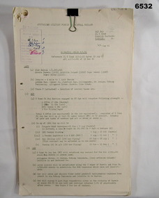 Bendigo Military Museum
Administrative record - Royal Australian Survey Corps - Central Command Operation Order C/1/61 Northern Territory 1961, DAD Svy, HQ Central Command , Keswick Barracks, SA, 1961
... Northern Territory in 1961. The task is to acquire Survey Control for the production of maps coving the following 1:250 000 map areas of Alligator River, Mt Evelyn, Coburg Peninsula, (including the offshore Islands, Melville Island and Bathurst Island. ...Northern Territory in 1961. The task is to acquire Survey Control for the production of maps coving the following 1:250 000 map areas of Alligator River, Mt Evelyn, Coburg Peninsula, (including the offshore Islands, Melville Island and Bathurst Island. ...This is a Central Command Operation Order for the Royal Australian Survey Corps to conduct a Survey Operation in Northern Territory in 1961. The task is to acquire Survey Control for the production of maps coving the following 1:250 000 map areas of Alligator River, Mt Evelyn, Coburg Peninsula, (including the offshore Islands, Melville Island and Bathurst Island. The Operation Order details the tasks for the 6 x Officers (or equivalent) and 34 x OR's (or equivalent) and the support that was allocated including Frigate HMAS Gasgoyne, LSM landing craft, Trucks amphibian (DUKW), Helicopter and Cessna aircraft.A 11 x page foolscap size paper report and 1 x foldout map Annex held together with a paper clip. Two hole punched.Hand written File Number in top RH Corner "101-310-4". Distribution stamp in top LH Corner. Hand written No7 in Top RH Corner.royal australian survey corps, rasvy, fortuna, army survey regiment, army svy regt -
 Bendigo Military Museum
Journal - Desert Exploration - Extract from Northern Territory Lands and Survey Dept Annual Report 1960-61, Northern Territory Lands and Survey Branch, 1961
... Northern Territory Lands and Survey Dept Annual Report 1960-61 is about Desert Exploration between Wave Hill and Tennant Creek. The 2 x fold out maps are 1:1,000,000 scale with one showing a Levelling Traverse. The exploration took place during March and April 1960. This document has been included in the RASvy collection because it was valuable information that was needed by RASvy surveyors who were required to operate in the area...Northern Territory Lands and Survey Dept Annual Report 1960-61 is about Desert Exploration between Wave Hill and Tennant Creek. The 2 x fold out maps are 1:1,000,000 scale with one showing a Levelling Traverse. The exploration took place during March and April 1960. This document has been included in the RASvy collection because it was valuable information that was needed by RASvy surveyors who were required to operate in the area ...This Extract from Northern Territory Lands and Survey Dept Annual Report 1960-61 is about Desert Exploration between Wave Hill and Tennant Creek. The 2 x fold out maps are 1:1,000,000 scale with one showing a Levelling Traverse. The exploration took place during March and April 1960. This document has been included in the RASvy collection because it was valuable information that was needed by RASvy surveyors who were required to operate in the area in later years.5 x foolscap sized pages and 2 x map foldout pages held together with a slide clip. Pages and maps are two hole punchedroyal australian survey corps, rasvy, fortuna, army survey regiment, army svy regt, asr -
 Kiewa Valley Historical Society
Photograph - Coloured Photographs x 5 - Bogong High Plains, January 1969 and c1970
... northern end . Howard Michell made it out to Glen Valley, a small mining town, to get help. Mick and Cleve were carried out on rough bush stretchers and Cleve died a few hours later. The Summit Hut was funded by Howard Michell and built in the 1940's. It was deliberately burnt down in the early 1980's. Bivouac hut was rebuilt in the 1980's. These photographs are of historical significance. Both huts were funded by experienced bushwalkers to provide shelter from the weather and so make walking and skiing in the area ...Bivouac Hut was built in 1935 on the Northern end of Mt. Bogong, on the Staircase Spur, about halfway to the summit. It was funded by Cleve Cole and he arranged for Walter Maddison to build it. Cleve Cole dedicated his life to the mountains and wanted to make them safer to visit - more huts and improved maps, pole lines and tracks. He perished in the winter of 1936 after attempting to make the first winter crossing from Mt. Hotham to Mt. Bogong on skis. The two others with him, Howard Michell and Mick Hull survived. The weather conditions were extreme at the time and having made the summit of Mt. Bogong they then became disorientated in the blizzard and came down the southern end of Bogong instead of the northern end . Howard Michell made it out to Glen Valley, a small mining town, to get help. Mick and Cleve were carried out on rough bush stretchers and Cleve died a few hours later. The Summit Hut was funded by Howard Michell and built in the 1940's. It was deliberately burnt down in the early 1980's. Bivouac hut was rebuilt in the 1980's.These photographs are of historical significance. Both huts were funded by experienced bushwalkers to provide shelter from the weather and so make walking and skiing in the area safer. They are both now gone with Bivouac being replaced with a more modern structure but there is nothing left of the Summit Hut. 5 coloured photographs, A4 in size, 4 near the summit of Mt. Bogong (Three of the Summit Hut) and one of Bivouac Hut on the Staircase Spur leading up to the summit.1. Hand written in ink on back of Photo - "Mt. Bogong Sep. 1976' - all underlined. Below this "Staircase Spur Hut The bloke in the hat me (David Jones)". 2. Handwritten in ink on back of photo - "Mt. Bogong winter 1970" (underlined). Underneathe "Same old Hut". 3. Handwritten in ink "Mt. Bogong Jan. 1969" (Underlined) Underneath "Tawonga Saddle looking towards the Summit". 4.Handwritten in ink back of photo "Mt. Bogong Jan. 1969" (underlined) Old hut near Summit, since removed, at the top of Staircase Spur. View looking out over Kiewa Valley." 5.Hand written on back of photo "Mt. Bogong Jan. 1969" (Underlined). Underneath - " Same old Hut (Staircase Spur) early morning".mt. bogong, summit hut, bivouac hut -
 Kiewa Valley Historical Society
Bridle Horse, circa mid to late 1900's
... Northern territory cattle stations in the late 1900's started to use helicopters for "cattle control". In the KIEWA Valley/Bogong High Plains and other rural cattle/sheep producing areas required well trained stock horses and stockmen for cattle/sheep control. ...Northern territory cattle stations in the late 1900's started to use helicopters for "cattle control". In the KIEWA Valley/Bogong High Plains and other rural cattle/sheep producing areas required well trained stock horses and stockmen for cattle/sheep control. ...This stock horse bridle was probably used in the mid 1900's. This was the period when cattle and sheep mustering was at its prime. The movement of cattle and sheep was by mounted stock horse only and not by other methods. Northern territory cattle stations in the late 1900's started to use helicopters for "cattle control". In the KIEWA Valley/Bogong High Plains and other rural cattle/sheep producing areas required well trained stock horses and stockmen for cattle/sheep control. It is only in the later 1900's that motor bikes and four wheeled quad-bikes have taken over, in part, from the mounted stockman.This horse bridle is very significant to the Kiewa Valley because of the early introduction of cattle and sheep stations in what initially was regarded as a semi remote valley location. The maintenance of cattle and sheep in the Kiewa Valley was, and still is an important requirement of livestock management. A good stock horse bridle is important, especially during the period when cattle and sheep were grazed on the Bogong High Plains. The mustering and and moving cattle/sheep from the valley pastures to the high country was a demanding and dangerous exercise requiring "sure footed" stock horses.The "good specialised" bridle was a vital part of this cattle/sheep mustering. A scientific study started in 1947 to study the impact of grazing cattle/sheep on the natural Alpine and sub Alpine vegetation found grazing cattle had an adverse affect on the natural Alpine and sub alpine vegetation, and grazing on the plains was stopped by the Victorian Government in 2005.This "camp draft" on the Bogong High Plains could take up to six weeks.This harness bridle includes "blinders, winklers or blinkers" and would therefore be used on a pack or "working" horse. This bridle has rings on each end of the browband. The bridle is one used by a horse working in a team configuration pulling a heavy cart or wagon. The bridle has ten adjustable straps to allow it to accommodate a variety of horse sizes. See KVHS 0495 for a stock horse saddle.horse, country, leather bridle, gaiters, high country grazing, cattlemen, laces, studs -
 Bendigo Military Museum
Photograph - FRAMED WW1 PHOTOGRAPH, Wayne Eels, C.2008/2009
... northern France. Refer Cat No. 1280 for Jack Grintons service details. Framed accessories Camera on the Sommne WW1 38th Bn Grinton Le Havre "Group 3: Trip of a Lifetime" "H. Port of Le Havre". Photograph framed. Photograph - black and white photograph on paper depicting a port scene, foreground - paved area ...The Grinton Collection. The Port of Le Harve, port city on the Seine River northern France. Refer Cat No. 1280 for Jack Grintons service details. Photograph framed. Photograph - black and white photograph on paper depicting a port scene, foreground - paved area with lamp posts, water. - background - ships, some with masts, with buildings behind. Frame - timber, light varnish finish, Perspex front, cardboard backing."Group 3: Trip of a Lifetime" "H. Port of Le Havre".framed accessories, camera on the sommne, ww1, 38th bn, grinton, le havre -
 Bendigo Military Museum
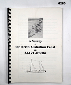
Booklet - A survey of the North Australian Coast on AK121 Aroetta, NT Force, NT Coastal Recce Unit RAE, 6 Aust Army Topo Survey Corps, AKA121 Aroetta, 28 Mar 1945
... northern parts. The best maps in existence of the N.T. coast in Dec "41 were those made by Matt Flinders in 1801 -1802. The Army soon got out new maps of all important areas including much of the inland. ...northern parts. The best maps in existence of the N.T. coast in Dec "41 were those made by Matt Flinders in 1801 -1802. The Army soon got out new maps of all important areas including much of the inland. ...The work of the Australian Survey Corps is to make maps for the Army. At the outbreak of war very little of the mainland had been mapped, especially the northern parts. The best maps in existence of the N.T. coast in Dec "41 were those made by Matt Flinders in 1801 -1802. The Army soon got out new maps of all important areas including much of the inland. Later it was decided to bring the complete coastline up to date. Several parties put in between them six months on the coast during the dry season of "45 but a couple more months would be needed to complete the program when the "wet" interrupted the work. A small section from Buckingham Bay - Groote Eylandt was still untouched and this diary covers that section of the N.T. Coast. A survey party of four men was chosen who were to be transported from place to place by the AK121 Aroetta - a ketch of 25 tons belonging to an army unit called N.T. Coastal Recce whose work it was to patrol the coast and as well do air - sea rescue. The survey party: Lieut Jack Worsley (the Loot) Sgt Jack Love, Spr Jack Cook, Spr Pat Hede. Crew of Aroetta: Liet Ralph Warne (Skipper), Sgt Buckley (Buck) (First Mate and Orderly Rm), Sgt Jim Terjesen (Jumbo) Bosun, WO2 Tom Davis (Engineer), Cpl Kevin Monk (Artificer), L/Cpl Jack Cox (Deck Hand), Spr Jack Andrews (Signals), Spr Laurie Rament (Ass. Engineer), Spr McKenzie (Mac) (Cook). The complete history is not available after July 31 1945. The remainder of the notes are very badly water-damaged and in some places unreadable.A4 Booklet, plain paper with text and diagrams and half tone photograph of Lt Jack Worsley with plastic binderSigned by George Barton Maj. for LtCol GS. NT Forceroyal australian survey corps, rasvy, fortuna, army survey regiment, army svy regt, asr -
 Bendigo Military Museum
Photograph - Johnson Ground Elevation Meter (JGEM) Survey Vehicle - Army Survey Regiment, Fortuna, Bendigo, c1960s
... areas of Queensland. CPL John Hook was the JGEM’s main operator in the early 1970s undertaking operations covering 1:250,000 scale map blocks over northern Victoria and central NSW, each requiring 36 points (9 runs of photography and 4 points across. ...areas of Queensland. CPL John Hook was the JGEM’s main operator in the early 1970s undertaking operations covering 1:250,000 scale map blocks over northern Victoria and central NSW, each requiring 36 points (9 runs of photography and 4 points across. ...This is a set of 16 photograph of the Royal Australian Survey Corps’ Johnson Ground Elevation Meter (JGEM) Survey Vehicle taken at the Army Survey Regiment, Fortuna, Bendigo. The JGEM vehicle was extensively used by RA Svy within Australia from the late 1960s. A limited number of Ground Elevation Meter (GEM) station wagon type vehicles were manufactured by General Motors Corporation (GMC) in the USA for the United States Geological Survey, Canada’s mapping agencies, RA Svy and National Mapping (Natmap). The GEM was a four-wheel drive, four-wheel steer vehicle. Four-wheel steering was necessary to avoid systematic errors caused by non-tracking of front and rear wheels on conventionally steered vehicles. The manufacturer substituted the rear axle with a front axle and connected them to form the four-wheel steering mechanism. The two Australian GEM vehicles, referred to as Johnson GEMs (JGEMs) were converted into right-hand drive. After delivery in 1964, acceptance Natmap and RA Svy testing and operator training was undertaken at the Army's School of Military Survey located at Balcombe, Victoria. A small fifth wheel was mounted on a cantilever arm suspension midway between the front and rear wheels on the right side of the vehicle. It was lowered to and raised from its operating position by use of a constant pressure air cylinder. A telescopic bar, suspended between the front and rear axles, provided the reference datum for the angle measurement. The wheel provided the velocity or distance signal through a pulse generator system. A sensitive pendulum mounted on this bar provided the angle measurement for each minute distance traversed. The JGEM contained electromechanical instruments used to determine relative elevations, by trigonometric principles, along a traversed path. These relative elevations were obtained through apparatus which measures the instantaneous angle of inclination of the road and the instantaneous velocity of the meter along such a path. Road routes over which the JGEM operated were planned so that each started and ended as near as practicable to an existing point of known elevation (formally referred to as a level traverse bench mark). The difference in height from the bench mark and the road surface alongside the JGEM’s fifth wheel was measured with a level and staff. Along each route, mapping control photo reference points where new elevation values were required were identified on aerial photographs. Under favourable conditions it was possible to survey as much as 160km in an ordinary working day. The first of RA Svy’s JGEM operations was undertaken in 1:250,000 scale map areas of Queensland. CPL John Hook was the JGEM’s main operator in the early 1970s undertaking operations covering 1:250,000 scale map blocks over northern Victoria and central NSW, each requiring 36 points (9 runs of photography and 4 points across. SPR Lyn Thompson and SPR Bob McDonagh teamed with CPL Hook on some of these JGEM operations. When RA Svy was integrated into the Royal Australian Engineers in 1996, the JGEM vehicle with the Survey Corps collection was donated to its museum. It is believed to be the last of the original manufactured fleet in existence. The JGEM has undergone extensive refurbishment to achieve roadworthiness and is currently housed at The Australian Army Museum of Military Engineering, Hoslworthy Barracks, NSW. It can be viewed by making an appointment with the museum’s curator.This is a set of 16 photograph of the Royal Australian Survey Corps’ Johnson Ground Elevation Meter (JGEM) Survey Vehicle taken at the Army Survey Regiment, Fortuna, Bendigo. The photographs were on 35mm slide film and were scanned at 96 dpi. They are part of the Army Survey Regiment’s Collection. .1) - Photo, colour, c1960s, Johnson Ground Elevation Meter (JGEM) Survey Vehicle .2) - Photo, colour, c1960s, JGEM instrumentation, on-board computer. .3) - Photo, colour, c1960s, JGEM instrumentation. .4) - Photo, colour, c1960s, JGEM instrumentation, on-board computer. .5) - Photo, colour, c1960s, JGEM tyre pressure controller .6) - Photo, colour, c1960s, JGEM rear doors, SGT Geoff Briggs. .7) - Photo, colour, c1960s, JGEM 5th wheel distance/angle measurement device in lowered position, SGT Geoff Briggs. .8) - Photo, colour, c1960s, JGEM 5th wheel distance/angle measurement device in lowered position. .9) & .10) - Photo, colour, c1960s, JGEM tyre pressure system, SGT Geoff Briggs. .11) - Photo, colour, c1960s, JGEM tyre pressure system. SGT Geoff Briggs. .12) - Photo, colour, c1960s, JGEM levelling scope, levelling staff, unidentified technicians. .13) & .14) - Photo, colour, c1960s, JGEM levelling scope, unidentified technician. .15) & .16) - Photo, colour, c1960s, probably survey operation adjusted height plotted on block base sheet. .1P to .16P - Some of the equipment is annotated on the frame of the 35mm slides.royal australian survey corps, rasvy, army survey regiment, army svy regt, fortuna, asr, surveying -
Port of Echuca
Audio - Oral History - Geoff Evans, Oral History of Geoffrey Thomas Evans of Echuca b1924 d 2007
... northern end of the Echuca Wharf from 1923 to 1983. His grandfather Richard James Evans orig. of England, settled in Victoria at a young age. He first worked as a butcher and later cut firewood in the Heathcote and Bacchus Marsh area. ...northern end of the Echuca Wharf from 1923 to 1983. His grandfather Richard James Evans orig. of England, settled in Victoria at a young age. He first worked as a butcher and later cut firewood in the Heathcote and Bacchus Marsh area. ...Geoff Evans was the third generation to run Evans Brothers Sawmills that operated from the northern end of the Echuca Wharf from 1923 to 1983. His grandfather Richard James Evans orig. of England, settled in Victoria at a young age. He first worked as a butcher and later cut firewood in the Heathcote and Bacchus Marsh area. ‘R.J.’, as he was known established a sawmill at Barmah in the 1890s, before relocating to this site in 1923. It became known officially as the Evans Bros. Echuca Red Gum Sawmill. This site proved more economical due to its position at the railhead. Paddlesteamers towed barges carrying the logs from the surrounding forests to this mill. The Steamers that were owned by the Evans family were the Edwards (built 1875) and the Melbourne (built 1912). The Edwards was the main towing vessel. Outrigger barges at this mill were the Impulse (1885), Alison (1907), Clyde (once a paddlesteamer, built in 1884). Insider barges at the mill were old wool barges with iron topsides, the J.L.Roberts (1894), ADA (1899) and the Whaler which was of wooden construction. The Evans Mill cut both red gum and Murray pine. There was a main mill for the red gum and a second one for the pine on this site. Two new Marshall steam engines had been purchased by the family, one was used in the P.S. Edwards and the other for the Barmah mill and later this site. The Evans Bros. Mill was very much a family concern with it being owned and operated firstly by R.J., then his son Frederick. R. Evans and later grandson Geoff Evans. The mill employed 18 workers and operated until the 1980s, only briefly was it in the hands of other owners before the construction on part of the site of a tourist-oriented building known as the Red Gum Works which eventually made way for the Port of Echuca Discovery Centre in 2014.Knowledge of the redgum timber milling industry and associated mechanisms such as log slips is scant with little photographic representations to be found. The industry created alongside the Murray River in various places was very unique given the nature of red gum not floating and ingenuity and making use of local resources was required. Geoff Evans had firsthand knowledge of much of this process and how the Echuca Wharf area used to be in past decades. Geoff was also a popular musician and mayor of Echuca so had much knowledge of the local history and community.Digital recording of oral history interview with Geoff Evans of Evans Brothers Sawmill Echuca. evans bros, evans bros saw mills, evans' sawmill, geoff evans, log slip, log skid, p.s. edwards, p.s. melbourne, impulse barge, allison barge, clyde barge, j.l. roberts barge, ada barge, whaler barge, murray pine, redgum, marshall engines, r.j evans, f.j. evans, discovery centre, p.s. marion -
4th/19th Prince of Wales's Light Horse Regiment Unit History Room
Medal, Defence Medal, abt 1945
... Within Australia the area is the Northern Territory , north of 14 degrees 30 minutes south, and the Torres Strait Islands between 3 September 1939 and 2 September 1945. ...Within Australia the area is the Northern Territory , north of 14 degrees 30 minutes south, and the Torres Strait Islands between 3 September 1939 and 2 September 1945. ...The Defence Medal was instituted to provide recognition for specified periods of service in non-operational areas subjected to air attack or closely threatened. Eligibility The Defence Medal is awarded for six months service in a prescribed non-operational area subject to enemy air attack or closely threatened, in Australia and overseas, or for 12 months service in non-prescribed non-operational areas. Within Australia the area is the Northern Territory , north of 14 degrees 30 minutes south, and the Torres Strait Islands between 3 September 1939 and 2 September 1945. Overseas service includes the Middle East, east of the Suez Canal (less the period of the Syrian Campaign) or Malaya prior to the Japanese invasion on 8 December 1941. The Medal The Defence Medal is cupro-nickel, with the uncrowned effigy of King George VI on the obverse. The reverse has a conventional oak tree centrally, with a crown above, with two lions counter rampart as supporters between the dates 1939 and 1945. The base of the medal reverse has the words ‘THE DEFENCE MEDAL'. The Ribbon The Defence Medal ribbon is orange with green outer stripes, each green stripe having a black pin-stripe running down the centre. The green represents the Islands of the United Kingdom, the orange represents enemy attacks, and the black represents the black outs.Full size and miniature medals with ribbonsnildefence medal -
 Kiewa Valley Historical Society
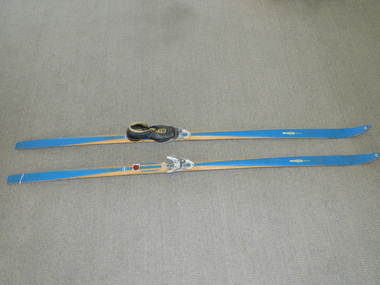
Skis Snow Competition, circa 1966
... The post World War II migration of European "snow skiiers" into Australia combined with the construction of Hydo Electricity Schemes in both the N.S.W.and Victorian Alps regions, opened up these winter snow areas to a greater influx of tourists and holiday adventurers interested in "winter" sports. The ability to project, on a global scale, skiing facilities of international standards to those in the northern hemisphere during their summer has opened up the Australia ski resorts and their facilities to a much greater winter sport orientated population. ...Kiewa Valley Historical Society Mount Beauty Information Centre 31 Bogong High Plains Rd Mt Beauty high-country The post World War II migration of European "snow skiiers" into Australia combined with the construction of Hydo Electricity Schemes in both the N.S.W.and Victorian Alps regions, opened up these winter snow areas to a greater influx of tourists and holiday adventurers interested in "winter" sports. The ability to project, on a global scale, skiing facilities of international standards to those in the northern hemisphere during their summer has opened up the Australia ski resorts and their facilities to a much greater winter sport orientated population. ...The post World War II migration of European "snow skiiers" into Australia combined with the construction of Hydo Electricity Schemes in both the N.S.W.and Victorian Alps regions, opened up these winter snow areas to a greater influx of tourists and holiday adventurers interested in "winter" sports. The ability to project, on a global scale, skiing facilities of international standards to those in the northern hemisphere during their summer has opened up the Australia ski resorts and their facilities to a much greater winter sport orientated population. These cross country skis were purchased by a member of the Bogong Ski Club and were part of a bulk ski stock consignment from Finland in 1966/67. They were introduced into the Victorian Alps to encourage skiers to take up cross country skiing both at Falls Creek and Mount Buller. This initiative spurred on the now annual 42 kilometre cross country "Kangaroo Hoppet" race at Falls Creek. This race is currently the biggest cross country snow skiing race in Australia. These snow skis were made in Finland. They are wooden (hickory) skis and made from four strips (glued and shaped) pieces of wood that are not laminated. There is a painted blue flash on the top of the skis that extends the full length of the skis. The face of the underside of the skis is flat and is coated in black Stockholm tar. Glider or grip wax was applied onto this base. The top body of the skis is tapered from shoe position to both front and back tips.Tapered curvatures from foot radiating to all sides provides the required aerodynamics. Metal boot bindings consisting of a toe plate with adjustable toe clip and a heel plate, both of which are screwed onto the skis. "KILPA, KARHU URHEILUTARPEITA SPORTART1KLAR, Karhu-Valtz Finland. Hickorypohjin"snow skiing, cross country skiing, falls creek winter tourism -
 Kiewa Valley Historical Society
Saddle Horse Stock, Circa 1950
... Northern territory cattle stations in the late 1900's started to use helicopters for "cattle control". In the KIEWA Valley/Bogong High Plains and other rural cattle producing areas required well trained stock horses and stockmen for cattle control. ...Northern territory cattle stations in the late 1900's started to use helicopters for "cattle control". In the KIEWA Valley/Bogong High Plains and other rural cattle producing areas required well trained stock horses and stockmen for cattle control. ...This stock horse saddle was probably used in the mid 1900's. This was the period when cattle mustering was at its prime. The movement of cattle was by mounted stock horse only and not by other methods. Northern territory cattle stations in the late 1900's started to use helicopters for "cattle control". In the KIEWA Valley/Bogong High Plains and other rural cattle producing areas required well trained stock horses and stockmen for cattle control. It is only in the later 1900's that motor bikes and four wheeled quad-bikes have taken over, in part, from the mounted stockman.This horse saddle is very significant to the Kiewa Valley because of the early introduction of cattle stations in what initially was regarded as a semi remote location. The maintenance of cattle in the Kiewa Valley is and was an important requirement. A good stock horse saddle as and is important, especially during the period when cattle were grazed on the Bogong High Plains. The mustering and and moving cattle from the valley pastures to the high country was a demanding and dangerous exercise requiring "sure footed" stock horses.The "good" saddle was a vital part of this cattle mustering. A scientific study started in 1947 to study the impact of grazing cattle on the natural Alpine and sub Alpine vegetation found grazing cattle had an adverse affect on the natural Alpine and sub alpine vegetation, and grazing on the plains was stopped by the Victorian Government in 2005.This "camp draft" in the High Plains could take up to six weeks.This all leather "stock horse" saddle shows plenty of wear. It is in "full harness" configaration with stirrups and leg protectors horse, country, leather, gaiters, high, grazing, cattlemen, laces, studs