Showing 33 items matching "observation towers"
-
 Bendigo Military Museum
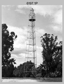
Photograph - Royal Australian Survey Corps Survey Observation Towers, c1950s
... Royal Australian Survey Corps Survey Observation Towers...Royal Australian Survey Corps Survey Observation Towers...Survey observation towers were used mainly to take angular measurements in flat or heavily forested terrain, where height was necessary to achieve observer’s line-of-sight between field survey station. ...The photographs were scanned at 300 dpi. .1) - Photo, black & white, c1950s, ‘Bilby’ survey observation tower. .2) - Photo, black & white, c1950s, CAPT George Ricketts climbing ‘Bilby’ survey observation tower. .3) - Photo, black & white, c1950s, geodetic survey equipment on ‘Bilby’ survey observation tower. .4) - Photo, black & white, c1950s, two unidentified field surveyors on ‘Bilby’ survey observation tower. .5) - Photo, black & white, c1950s, two unidentified field surveyors, with CAPT Ricketts climbing ‘Bilby’ survey observation tower. .6) - Photo, black & white, c1950s, two unidentified field surveyors undertaking observations on survey observation tower. .7) - Photo, black & white, c1950, two unidentified field surveyors erecting or dismantling a survey observation tower....Royal Australian Survey Corps Survey Observation Towers Photograph Royal Australian Survey Corps Survey Observation Towers Army Survey Regiment ...This is a set of seven photographs of Royal Australian Survey Corps surveyors setting up observation towers in the field and undertaking survey observations during mapping and geodetic control operations. c1950s. Survey observation towers were used mainly to take angular measurements in flat or heavily forested terrain, where height was necessary to achieve observer’s line-of-sight between field survey station. The Bilby Tower seen in photo .5P was erected to a height of 75 feet (23m) above ground level. The use of the Bilby Tower in Topographic Squadron’s field survey operations from 1955 to 1966 is described in page 54 of Valerie Lovejoy’s book 'Mapmakers of Fortuna – A history of the Army Survey Regiment’ ISBN: 0-646-42120-4. CAPT George Ricketts’ period of service was from 1942 to 1976 reaching the rank of LTCOL. It is noted in page 35 of Valerie Lovejoy’s book that then SGT Ricketts hand lettering skills came to the fore from his contribution to the draughting of one of the Japan’s Instruments of Surrender in 1945.This is a set of seven photographs of Royal Australian Survey Corps surveyors setting up observation towers in the field and undertaking survey observations during mapping and geodetic control operations. c1950s. The photographs were printed on photographic paper and are part of the Army Survey Regiment’s Collection. The photographs were scanned at 300 dpi. .1) - Photo, black & white, c1950s, ‘Bilby’ survey observation tower. .2) - Photo, black & white, c1950s, CAPT George Ricketts climbing ‘Bilby’ survey observation tower. .3) - Photo, black & white, c1950s, geodetic survey equipment on ‘Bilby’ survey observation tower. .4) - Photo, black & white, c1950s, two unidentified field surveyors on ‘Bilby’ survey observation tower. .5) - Photo, black & white, c1950s, two unidentified field surveyors, with CAPT Ricketts climbing ‘Bilby’ survey observation tower. .6) - Photo, black & white, c1950s, two unidentified field surveyors undertaking observations on survey observation tower. .7) - Photo, black & white, c1950, two unidentified field surveyors erecting or dismantling a survey observation tower..1P with paper tag annotated ‘Bilby Tower’ .4P on back – ‘Bilby Tower’. .5P on back – ‘Survey Observing Tower. Observing tower used for angular measurement in flat country. 75’ high – CAPT Ricketts climbing. .6P, .7P on back. ‘1960s?’royal australian survey corps, rasvy, army survey regiment, army svy regt, fortuna, asr, surveying -
 Tatura Irrigation & Wartime Camps Museum
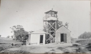
Photograph, South Guard Observation Tower Dhurringile, 1940
... South Guard Observation Tower Dhurringile......observation towers...Black and white photograph of south guard observation tower with a shed either side....South Guard Observation Tower Dhurringile Photograph Photograph ...Dhurringile guard duty.Black and white photograph of south guard observation tower with a shed either side.dhurringile pow camp, observation towers -
 Tatura Irrigation & Wartime Camps Museum
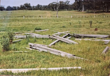
Photograph, Arthur Knee, Guard tower ruins camp 13, 1989
... ...observation tower...Camp 13 guard observation tower beams (ruins) in paddock. Timber and wire fence mid distance....Timber beams, remnants of guard observation tower (foreground)....Timber beams, remnants of guard observation tower (foreground). Guard tower ruins camp 13 Photograph Photograph Arthur Knee ...Camp 13 guard observation tower beams (ruins) in paddock. Timber and wire fence mid distance.Camp 13, Camp Road, Murchison, Victoria. Timber beams, remnants of guard observation tower (foreground).camp 13, internment camp, murchison victoria, observation tower, ruins, guard tower ruins -
 Darebin Parklands Association
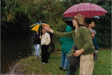
Ranger Peter Wiltshire throwing water plants into the wetlands, Darebin Parklands Association, 1993
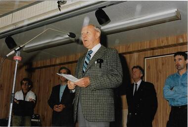
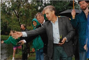
... This photograph is one of a series of 76 in folder P001 - taken at the opening of the observation tower....Opening of the observation tower. This item and all other Darebin Parklands Association archival material is now held by State Library Victoria (Accession No: YMS 13746). ...Alphington melbourne This photograph is one of a series of 76 in folder P001 - taken at the opening of the observation tower. Colour photograph. Opening of the observation tower. ...This photograph is one of a series of 76 in folder P001 - taken at the opening of the observation tower.Colour photograph. Opening of the observation tower. This item and all other Darebin Parklands Association archival material is now held by State Library Victoria (Accession No: YMS 13746). Please contact State Library Victoria if access is required. -
 Darebin Parklands Association
Ron Gleeson on stage, 1993
... This photograph is one of a series of 76 in folder P001 - taken at the opening of the observation tower....Ron Gleeson president of the DCMC at the opening of the observation tower. This item and all other Darebin Parklands Association archival material is now held by State Library Victoria (Accession No: YMS 13746). ...Alphington melbourne This photograph is one of a series of 76 in folder P001 - taken at the opening of the observation tower. Colour photograph. Ron Gleeson president of the DCMC at the opening of the observation tower. ...This photograph is one of a series of 76 in folder P001 - taken at the opening of the observation tower.Colour photograph. Ron Gleeson president of the DCMC at the opening of the observation tower. This item and all other Darebin Parklands Association archival material is now held by State Library Victoria (Accession No: YMS 13746). Please contact State Library Victoria if access is required. -
 Darebin Parklands Association
Throwing water plants into the wetlands, Darebin Parklands Association, 1993
... This photograph is one of a series of 76 in folder P001 - taken at the opening of the observation tower....Sue Course, Vin Heffernan and Rob Gell at the opening of the observation tower. This item and all other Darebin Parklands Association archival material is now held by State Library Victoria (Accession No: YMS 13746). ...Alphington melbourne This photograph is one of a series of 76 in folder P001 - taken at the opening of the observation tower. Colour photograph. Sue Course, Vin Heffernan and Rob Gell at the opening of the observation tower. ...This photograph is one of a series of 76 in folder P001 - taken at the opening of the observation tower.Colour photograph. Sue Course, Vin Heffernan and Rob Gell at the opening of the observation tower. This item and all other Darebin Parklands Association archival material is now held by State Library Victoria (Accession No: YMS 13746). Please contact State Library Victoria if access is required. -
 Buninyong & District Historical Society
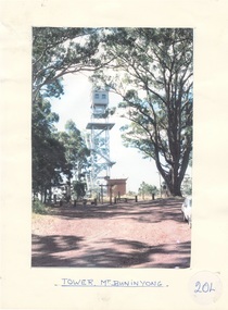
Photograph - Original Photograph, Mount Buninyong Tower, 1980's
... Colour photo, Buninyong Observation tower...Buninyong & District Historical Society Old Court House, Buninyong Town Hall 313 Learmonth Street Buninyong goldfields historic, Civil engineering Mount Buninyong Tower Colour photo, Buninyong Observation tower Mount Buninyong Tower Photograph Original Photograph Derek Leather ...historic, Civil engineeringColour photo, Buninyong Observation towermount buninyong, tower -
 National Vietnam Veterans Museum (NVVM)
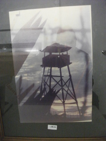
Photograph, Observation Tower
... Observation Tower......Observation Tower...Framed coloured photograph of an Observation Tower manned by two soldiers at a Firebase....Observation Tower Photograph Photograph ...Framed coloured photograph of an Observation Tower manned by two soldiers at a Firebase.photograph, firebase, observation tower -
 Lakes Entrance Historical Society
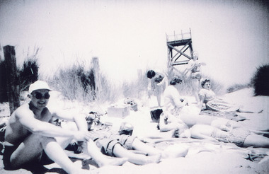
Photograph - Ocean beach Royal Lifesaving Club Tower, Lakes Entrance c1960, Scarce, Heather
... Showing the observation tower in background. Tower built for Royal Lifesaving Club. ...Showing the observation tower in background. Tower built for Royal Lifesaving Club. ...Spotting tower for lifesaving club built 1937cBlack and white photograph of eight people, some in bathing costumes, sitting on the sand hummock. Showing the observation tower in background. Tower built for Royal Lifesaving Club. Lakes Entrance Victoria people, topography, beaches -
 National Vietnam Veterans Museum (NVVM)
Photograph, Gibbons, Denis, Observation Tower 2
... Observation Tower 2......Observation Tower...A black and white photograph of the observation tower at an Australian Fire Support Base - the Diggers used the tower to maintain a close and distant surveilance of any possible NVA/VietCong movement, which may prove dangerous to those in the confines of the Fire Support Base....Observation Tower 2 Photograph Gibbons, Denis ...Denis Gibbons (1937 – 2011) Trained with the Australian Army, before travelling to Vietnam in January 1966, Denis stayed with the 1st Australian Task Force in Nui Dat working as a photographer. For almost five years Gibbons toured with nine Australian infantry battalions, posting compelling war images from within many combat zones before being flown out in late November 1970 after sustaining injuries. The images held within the National Vietnam Veterans Museum make up the Gibbons Collection. A black and white photograph of the observation tower at an Australian Fire Support Base - the Diggers used the tower to maintain a close and distant surveilance of any possible NVA/VietCong movement, which may prove dangerous to those in the confines of the Fire Support Base.photograph, fire support base, nva/vc, observation tower, gibbons collection catalogue, denis gibbons, photographer, vietnam war, diggers -
 Lakes Entrance Historical Society
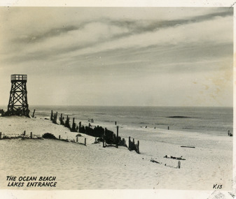
Postcard - Ocean Beach Lakes Entrance 1950's, c1950
... It shows an expanse of sand dune, remains of a brush windbreak fence and the observation tower - built for Royal Lifesaving Club, prior to formation of the Surf Life Saving Club. ...It shows an expanse of sand dune, remains of a brush windbreak fence and the observation tower - built for Royal Lifesaving Club, prior to formation of the Surf Life Saving Club. ...Black and white small format postcard of the Ocean Beach. It shows an expanse of sand dune, remains of a brush windbreak fence and the observation tower - built for Royal Lifesaving Club, prior to formation of the Surf Life Saving Club. Lakes Entrance VictoriaThe Ocean Beach Lakes Entrancebeaches, surf lifesaving -
 National Vietnam Veterans Museum (NVVM)
Photograph, Gibbons, Denis, Observation Tower 1
... Observation Tower 1...A coloured photograph of A Gunner of 104 Battery Royal Australian Artillery at Fire Base Betty, mans the observation tower constructed in the Fire Support Base. the tower maintained a vigil on probing attempts by NVA/VietCong and assisted incoming helicopters druing Tet Offensive 1969...Photograph 104 Battery RAA Fire Base Betty NVA/VC Long Bien Tet Offensive 1969 Gibbons Collection Catalogue Gunner Royal Australian Artillery Fire Support Base NVA/VietCong Helicopters Denis Gibbons A coloured photograph of A Gunner of 104 Battery Royal Australian Artillery at Fire Base Betty, mans the observation tower constructed in the Fire Support Base. the tower maintained a vigil on probing attempts by NVA/VietCong and assisted incoming helicopters druing Tet Offensive 1969 Observation Tower 1 Photograph Gibbons, Denis ...Denis Gibbons (1937 – 2011) Trained with the Australian Army, before travelling to Vietnam in January 1966, Denis stayed with the 1st Australian Task Force in Nui Dat working as a photographer. For almost five years Gibbons toured with nine Australian infantry battalions, posting compelling war images from within many combat zones before being flown out in late November 1970 after sustaining injuries. The images held within the National Vietnam Veterans Museum make up the Gibbons Collection.A coloured photograph of A Gunner of 104 Battery Royal Australian Artillery at Fire Base Betty, mans the observation tower constructed in the Fire Support Base. the tower maintained a vigil on probing attempts by NVA/VietCong and assisted incoming helicopters druing Tet Offensive 1969photograph, 104 battery, raa, fire base betty, nva/vc, long bien, tet offensive, 1969, gibbons collection catalogue, gunner, royal australian artillery, fire support base, nva/vietcong, helicopters, denis gibbons -
 Whitehorse Historical Society Inc.
Article, Apex needs new blood, 1991
... They have just won a grant from the Department of Conservation and Lands to construct an observation tower at the rear of the waste transfer station on Burwood Highway, but they need more members to carry the project through, says Geoff Secker,. membership chairman....They have just won a grant from the Department of Conservation and Lands to construct an observation tower at the rear of the waste transfer station on Burwood Highway, but they need more members to carry the project through, says Geoff Secker,. membership chairman. ...Nunawading Apex club urgently wanting new members.Nunawading Apex club urgently wanting new members. They have just won a grant from the Department of Conservation and Lands to construct an observation tower at the rear of the waste transfer station on Burwood Highway, but they need more members to carry the project through, says Geoff Secker,. membership chairman.Nunawading Apex club urgently wanting new members. service clubs, secker, geoff, victoria. department of conservation and lands, nunawading apex club, waste transfer station, vermont south -
Whitehorse Historical Society Inc.
Article, Tip top view of the city, 1994
... Opening of the observation tower at old tip site. Nunawading Apex Club joined forces with neighbouring clubs to construct it. ...Whitehorse Historical Society Inc. 2-10 Deep Creek Road Mitcham melbourne service clubs nunawading apex club secker geoff victorian government city of nunawading reeves paul waste transfer station vermont south Opening of the observation tower at old tip site. Opening of the observation tower at old tip site. ...Opening of the observation tower at old tip site.Opening of the observation tower at old tip site. Nunawading Apex Club joined forces with neighbouring clubs to construct it. The State Government and Nunawading Council have funded the project and Apex Club members have donated 2000 hours work over the last two years to complete the structure.Opening of the observation tower at old tip site.service clubs, nunawading apex club, secker, geoff, victorian government, city of nunawading, reeves, paul, waste transfer station, vermont south -
 Bendigo Military Museum
Photograph - Royal Australian Survey Corps Surveyors in the Field – North Queensland, 1958
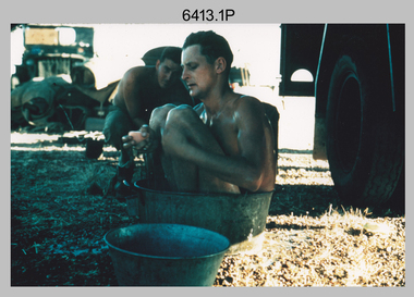
... Surveyors south of Richmond, QLD undertaking survey measurements from a Bilby observation tower....Surveyors south of Richmond, QLD erecting a Bilby observation tower. L to R: Tom Royle, Bob Skitch (on ground level), Mal Hayes. .6) - Photo, colour, 1958. ...This is a set of seven photographs of surveyors and support staff in the field undertaking duties in North Queensland in 1958. The surveyors were employed in the establishment of mapping and geodetic control. In this era surveyors used theodolites to observe horizontal and vertical angles and chains to measure base line distances between survey stations. Bob Skitch shown in photos .4P to .6P was in the 2nd year of his career in the Australian Army. He achieved the rank of Lieutenant Colonel and his last appointment was the CO of the Army Survey Regiment from 1976 to 1980. The annotation on the back of photo .5P ‘Black foreground is where Bob Skitch boiled billy and started a grass fire’.This is a set of seven photographs of surveyors and support staff in the field undertaking duties in North Queensland in 1958. The photographs were printed on photographic paper and are part of the Army Survey Regiment’s Collection. The photographs were scanned at 300 dpi. .1) - Photo, colour, 1958. Surveyor in Nth QLD enjoying a bath. L to R: Don Cocker, Bob Thompson. .2) - Photo, colour, 1958. Don Cocker surveyor in Nth QLD, enjoying a bath. .3) - Photo, colour, 1958. Surveyors Nth QLD undertaking survey observations, using MRA1 tellurometer to measure base-line distances. L to R: Len Davies, Lou Sommer, John Van De Graff. MRA1 was covered to stop overheating. .4) - Photo, colour, 1958. Surveyors south of Richmond, QLD digging holes for the erection of a Bilby observation tower. L to R: John Van De Graff, Bob Skitch, Kev Moody, Mal Hayes, Don Gray .5) - Photo, colour, 1958. Surveyors south of Richmond, QLD erecting a Bilby observation tower. L to R: Tom Royle, Bob Skitch (on ground level), Mal Hayes. .6) - Photo, colour, 1958. Surveyors south of Richmond, QLD erecting a Bilby observation tower. L to R: Tom Royle, Bob Skitch, Mal Hayes, Jim McGill (on ground level). .7) - Photo, colour, 1958. Surveyors south of Richmond, QLD undertaking survey measurements from a Bilby observation tower..1P to .7P annotated on back – personnel names, the year and the location. Annotated on back of .5P ‘Black foreground is where Bob Skitch boiled billy and started a grass fire’.royal australian survey corps, rasvy, army survey regiment, asr, army svy regt, fortuna, surveying -
 Lakes Entrance Historical Society
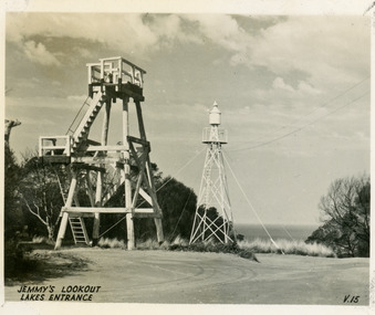
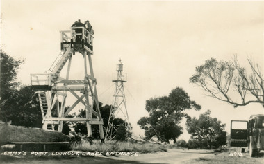
Postcard - Lookout tower Jemmy's Point, Valentine Series, 1940
... Black and white small format postcard of the timber observation lookout at Jemmy's Point, Lakes Entrance, Victoria, showing the timber tower with observation deck, signal beacon on steel tower nearby. ...Lakes Entrance Historical Society 4 Marine Parade Lakes Entrance gippsland Historic Sites Navigation Jemmys Lookout Lakes Entrance Black and white small format postcard of the timber observation lookout at Jemmy's Point, Lakes Entrance, Victoria, showing the timber tower with observation deck, signal beacon on steel tower nearby. ...Black and white small format postcard of the timber observation lookout at Jemmy's Point, Lakes Entrance, Victoria, showing the timber tower with observation deck, signal beacon on steel tower nearby. Top of old standing lookout tree just visible.Jemmys Lookout Lakes Entrancehistoric sites, navigation -
 Bendigo Military Museum
Photograph - SINO-JAPANESES, The Associated Press, Nov 1937
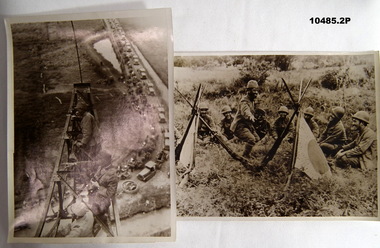
... Photo of Japanese soldiers sitting on top of Cheniu Radio Station tower for observation with troops moving to the line in background as well as civilians fleeing the front line. 2. ...Photo of Japanese soldiers sitting on top of Cheniu Radio Station tower for observation with troops moving to the line in background as well as civilians fleeing the front line. 2. ...Sino-Japan War started 1937 until 1945. Part of the collection of William (Bill) Thomason. Refer Cat No. 4136P. Two sepia photos of scenes from 2nd Sino-Japan War. 1. Photo of Japanese soldiers sitting on top of Cheniu Radio Station tower for observation with troops moving to the line in background as well as civilians fleeing the front line. 2. Photo of Japanese soldiers resting and playing games with rifles and flags stuck in the ground in the foreground. Both have detailed descriptions stuck on the back.Typed description glued to back in French. Also stamped from "Copyright - Associated Press Photo", and an address in Paris.photographs, collection of william (bill) thomason, sino-japan war -
Surrey Hills Historical Society Collection
Work on paper - Vertical file, Beckett Park and Maranoa Gardens
... 1. ‘Observation tower Beckett Park’, B.H. Reporter, 23.11.1934 (2 pages). 2. ...Surrey Hills Historical Society Collection 190A Canterbury Road Canterbury melbourne 1. ‘Observation tower Beckett Park’, B.H. Reporter, 23.11.1934 (2 pages). 2. ...1. ‘Observation tower Beckett Park’, B.H. Reporter, 23.11.1934 (2 pages). 2. ‘Glory of a native garden’, F. Chapman, Literary Section unknown paper, 2.9.1939 (1 page, 2 copies original and copy). 3. Copy ‘Centenary tower’, The Herald, 21.5.1937 (1 page). 4. ‘Maranoa’, Camberwell City News, August, 1990 (1 page). 5. ‘Rotary Club’s gift to garden’, ? Age, 1990s ? (1 page) 6. ‘Maranoa Gardens & Beckett Park’ supplement, Boroondara Bulletin, 1997 (2 page spread). 7. ‘Beckett Park revisited’ by Annie Gillison, 8.7.1985, Melbourne Week ? (1 page). 8. Maranoa gardens Boroondara Council brochure (undated) (1 page). 9. Re Mr. Arthur J. Swaby, information from various sources, undated (1 page). 10. Beckett Park – ‘Glory of a Native Garden’, F. Chapman, unnamed newspaper, 2.9.1939, copy. (1 page). 11. Beckett Park: information re Robert Beckett from various sources (2 pages). 12. ‘Most will like gardens plan’, unnamed newspaper, letter from Dennis Whelan, undated (1 page). 13. Extracts from J.A. Allan’s unpublished history of Camberwell re Beckett Park & Maranoa Gardens, undated (1 page). 14. Maranoa Gardens Self-guided walk, undated (4 page brochure). 15. Notes on F. Chapman and interests, various sources, (2 pages). 16. Empire Day celebrations, extract from Argus, 24.5.1937 (1 page). 17. Extract from Camberwell Conservation Plan, 1989 by McConville (1 page). 18. ‘A lesson in serenity’, Maranoa Botanic Gardens, Balwyn, Domain Review, 7.7.2021 (2 pages). 19. Boroondara City Council Notice of proposed naming of reserve, Progress Leader, 5.12.2019 (1 page). 20. Maranoa Botanic Gardens, undated (double sided pamphlet). 21. 2 extracts from Box Hill Recorder, 23.10.1925 and 27.11.1925 (1 page). 22. Extract from BHR, 15.1.1926 ‘Visit of Field Naturalists Club of Victoria’ (1 page). -
 Eltham District Historical Society Inc
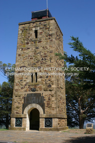
Photograph - Digital Photograph, Alan King, Shire of Eltham War Memorial, Kangaroo Ground, 28 January 2008
... Ness, secretary of the Kangaroo Ground bush fire brigade, who asked Council that the tower be used as an observation tower for detecting bush fires, and asked Council to arrange a telephone to be installed. ...Ness, secretary of the Kangaroo Ground bush fire brigade, who asked Council that the tower be used as an observation tower for detecting bush fires, and asked Council to arrange a telephone to be installed. ...The Eltham Shire War Memorial, a tower of remembrance, was built with public donations to commemorate the memory of the fallen soldiers from the shire who enlisted in the 1914-1918 war. The tower is reminiscent of the peel-towers or watchtowers that lined the English-Scottish border from the mid 14th century to around 1600 and is constructed from locally quarried stone. This uncommon and picturesque war memorial, which affords an excellent view of the surrounding district was unveiled by His Excellency the Governor-General (Lord Stonehaven) on November 11, 1926. In July 1922 a deputation of returned soldiers from Panton Hill, presumably the Panton Hill branch of the Returned Sailors and Soldiers Imperial League of Australia (RSSILA), proposed to Eltham Shire Council that the monument should be a cairn of local stone “sufficiently high to form a prominent and conspicuous landmark, and crowned with some suitable device”. Eltham Shire Councillor and President of the Panton Hill branch of the RSSILA, Basil Hall, was credited with being the first to suggest a tower, and with organising a Memorial Park committee to raise funds for the monument in the Memorial Park. A meeting for those interested in the establishing a War Memorial monument in the park was held in January 1924 and the Eltham Shire War Memorial League was formed for this purpose. It appears that the broad and rounded cairn that had been recently built was considered by the League a temporary affair, and not the substantial cairn-as-monument, sufficiently high to form the conspicuous landmark, which had been envisaged by the Panton Hill RSSILA. A design competition was held for the monument. The chairman of the League, Councillor Basil Hall, suggested that the site of the memorial in Kangaroo Ground would lend itself to something rugged, instead of polished stone. By April 1924 thirty designs for a memorial had been received from which three designs were selected and of those, the design by the shire engineer Mr McCormack, for a 70ft tower suitable for construction in rough stone, was chosen. Artist Harold Herbert suggested that a peel tower-like design reminiscent of those along the English-Scottish border would be fitting for the site. Herbert drew up a rough sketch that was approved of, and later, Melbourne architect Percy Meldrum volunteered to draw up the design from sketch to architectural drawings. By January 1925 the Soldiers’ Memorial League had adopted Meldrum’s design for a 50ft high tower. Meldrum had also offered his design and supervision of construction free of charge. The Shire provided the stone to the builders, which was a gift quarried from land owned at Kangaroo Ground by Dr Ethel and Professor William Osborne The Shire of Eltham War Memorial, a tower of remembrance, and honour board were unveiled on November 11, 1926, by the Governor General Lord Stonehaven. At this stage a temporary honour roll was painted on the panels on either side of the tower entrance. In September 1930 bronze plates were added above the portal with the names of men who fell in the 1914-18 war. On November 16, 1951, the Governor of Victoria, Sir Dallas Brooks re-dedicated the war memorial tower and unveiled the names of men who gave their lives in the 1939-45 war. Two additional bronze plaques which recognise service in the armed conflicts of Korea, Borneo, Malaya, and Vietnam were unveiled November 11, 2001, by the Governor of Victoria, John Landy, A.C., M.B.E. The tower was first used for fire spotting activities following the Black Friday bushfire in January 1939 in response to a request from Mr R.D. Ness, secretary of the Kangaroo Ground bush fire brigade, who asked Council that the tower be used as an observation tower for detecting bush fires, and asked Council to arrange a telephone to be installed. It was suggested that if the Shire were to appoint a caretaker for the Memorial Park, his duties could also include raising the alarm in the event of a fire. Later in 1939 Council applied for a radio transmitter, which the Forestry Commission planned to install at vantage places throughout the state. The first dedicated fire spotter appointed from December1948, was Mr Smith of Warrandyte. A prefabricated glazed cabin was installed in 1974, which involved the removal of the original stone structure around the rooftop exit door. A new fire spotting cabin, which included the latest technology, was installed soon after the 2009 Black Saturday fires and is manned by CFA personnel on high fire danger days. Covered under Heritage Overlay, Nillumbik Planning Scheme. Published: Nillumbik Now and Then / Marguerite Marshall 2008; photographs Alan King with Marguerite Marshall.; p123This collection of almost 130 photos about places and people within the Shire of Nillumbik, an urban and rural municipality in Melbourne's north, contributes to an understanding of the history of the Shire. Published in 2008 immediately prior to the Black Saturday bushfires of February 7, 2009, it documents sites that were impacted, and in some cases destroyed by the fires. It includes photographs taken especially for the publication, creating a unique time capsule representing the Shire in the early 21st century. It remains the most recent comprehenesive publication devoted to the Shire's history connecting local residents to the past. While published in the book in black and white, this collection features the original colour digital photographs. nillumbik now and then (marshall-king) collection, garden hill, kangaroo ground, memorial park, shire of eltham war memorial -
 Bendigo Military Museum
Photograph - RA Svy Project C4 Aerodist Operation, Eastern & Western Arnhem Land, NT, 1967, 1968
... observation helicopters had a limiting load carrying capacity of up to about 500 pounds. By comparison, one Aerodist team including two people weighed up to 1,500 pounds. In 1968, after completion of the Kimberley Aerodist Operation project, the Aerodist system in VH-EXX was immediately deployed to western-Arnhem Land NT for Central Comd Fd Svy Unit (Adelaide - Major Don Ridge) to complete the mapping control across northern NT from mid-July to October. The Aerodist MRC2 Remote antenna seen in Photos .24P to .26P is mounted on a 20 foot pole tower...observation helicopters had a limiting load carrying capacity of up to about 500 pounds. By comparison, one Aerodist team including two people weighed up to 1,500 pounds. In 1968, after completion of the Kimberley Aerodist Operation project, the Aerodist system in VH-EXX was immediately deployed to western-Arnhem Land NT for Central Comd Fd Svy Unit (Adelaide - Major Don Ridge) to complete the mapping control across northern NT from mid-July to October. The Aerodist MRC2 Remote antenna seen in Photos .24P to .26P is mounted on a 20 foot pole tower ...This is a set of 26 photographs of Royal Australian Survey Corps (RA Svy) personnel from Central Comd Fd Svy Unit (Adelaide) on Aerodist survey operation - Project C4 in Eastern Arnhem Land, Northern Territory in 1967 (photos .4P to .26P) and in Western Arnhem Land, Northern Territory in 1968 (photos .1P to .3P). Photos of personnel were taken either at the operations base at Numbulwar or the main base at Gove (Nhulunbuy). RA Svy conducted nineteen Aerodist operations for 12 years from 1964 to 1975. Aerodist MRC2 was a tellurometer-based system adapted for aircraft to accurately measure distances between non-intervisible ground survey stations, using the aircraft as an intermediate station. Lower order geodetic results could be achieved by survey network trilateration. The measured distances between stations formed survey networks from which each station’s latitude and longitude was computed. Aerodist MRC2 was RA Svy’s major horizontal control survey tool for mainly medium scale topographic mapping (scale 1:100,000 Class A being spatially accurate to within 50 metres) in PNG, northern NT, north-west WA, Kalimantan Barat (West) Indonesia, Sumatra Indonesia, Gulf of Carpentaria and Cape York, QLD. In 1967, the Aerodist MRC2 Master equipment was installed in the aircraft featured in this set of photos, Executive Air Services’ (Essendon VIC) Grand Aero Commander VH-EXX. It was the same aircraft type and company contracted to Division of National Mapping for Aerodist MRC2 surveys. From July to October 1967 the aircraft was attached to Central Comd Fd Svy Unit (Adelaide - Major Don Ridge) on Project C4 eastern-Arnhem Land NT, where 317 Aerodist lines measuring 17,300 line miles were successfully completed. This was the most productive Aerodist project thus far. The most common helicopter used by RA Svy up to 1972 was the civilian Bell 47G-2 and the Sioux Light Observation Helicopters (LOH), the Australian Army’s equivalent featured in this photo set. These light observation helicopters had a limiting load carrying capacity of up to about 500 pounds. By comparison, one Aerodist team including two people weighed up to 1,500 pounds. In 1968, after completion of the Kimberley Aerodist Operation project, the Aerodist system in VH-EXX was immediately deployed to western-Arnhem Land NT for Central Comd Fd Svy Unit (Adelaide - Major Don Ridge) to complete the mapping control across northern NT from mid-July to October. The Aerodist MRC2 Remote antenna seen in Photos .24P to .26P is mounted on a 20 foot pole tower. The antenna direction was controlled by wires/ropes to the two arms under the dish at right angles. The antenna elevation could be changed to the vertical for aircraft height checks as seen in photo .25P. Source: Royal Australian Survey Corps – Aerodist Years 1964-1975 by Peter Jensen. Refer to Item 6449.30P for more photos taken during these Aerodist survey operations.This is a set of 26 photographs of Royal Australian Survey Corps (RA Svy) personnel on Aerodist survey operations in Eastern Arnhem Land, Northern Territory in 1967 and Western Arnhem Land, Northern Territory in 1968. The photographs are on 35mm negative film and scanned at 96 dpi. They are part of the Army Survey Regiment’s Collection. .1) to .2) – Photo, black & white, 1968, unidentified soldier with an opened can of food, possibly bully beef. .3) – Photo, black & white, 15 Aug 1968, aerial view of terrain taken from a helicopter in vicinity of MILINGIMBI SIERRA. .4) – Photo, black & white, 1967, aerial view of an island taken from a helicopter. .5) & .6) – Photo, black & white, 1967, unidentified soldier driving a Haflinger 4x4 Light utility vehicle with trailer. .7) – Photo, black & white, 1967, unidentified surveyors taking vertical measurements with a leveling instrument and staff. .8) – Photo, black & white, 1967, Australian Army Sioux Light Observation Helicopter (LOH) with float removed. .9) to .11) – Photo, black & white, 1967, Australian Army Sioux Light Observation Helicopter (LOH) with floats. .12) – Photo, black & white, 1967, civilian Bell 47G-2 helicopter (Australian Army Sioux LOH equivalent) refuelled. .13) – Photo, black & white, 1967, survey station on coastline surrounded by white plastic aerial photographic identification panels lined with rocks. .14) & .15) – Photo, black & white, 1967, soldier (possibly a signaller from RA Sigs) operating a radio. .16) – Photo, black & white, 1967, Central Comd Fd Svy Unit Operations Section tent, Main Base Gove (Nhulunbuy) L to R: SPR Harry Dunn, WO1 Pat Wood BEM. .17) – Photo, black & white, 1967, Central Comd Fd Svy Unit Operations Section tent, Main Base Gove (Nhulunbuy) L to R: unidentified, WO1 Pat Wood BEM. .18) – Photo, black & white, 1967, Central Comd Fd Svy Unit Operations Section, Main Base Gove (Nhulunbuy), unidentified Australian Army Catering Corps cook preparing meals. .19) – Photo, black & white, 1967, Central Comd Fd Svy Unit Operations Section, Main Base Gove (Nhulunbuy) mess tent in readiness for meals. .20) – Photo, black & white, 1967, Bank of batteries in transit boxes undergoing recharging using generators. .21) – Photo, black & white, 1967, A topographic survey identification plaque set in a concrete block being weighed using a set of scales hanging from slaughtering gallows. .22) – Photo, black & white, 1967, CPL (Geoff or Gary) Larkin operating the remote Aerodist MRC2 ground instrument at Veronica Island, located north of Nhulunbuy. .23) – Photo, black & white, 1967, L to R: CPL (Geoff or Gary) Larkin with unidentified surveyor operate the remote Aerodist MRC2 ground instrument at Venica Island, located north of Nhulunbuy. .24) & .25 – Photo, black & white, 1967, The Aerodist MRC2 Remote antenna. .26) – Photo, black & white, 1967, The Aerodist MRC2 Remote antenna.The following photos are annotated in black ink on edge of film negative: .3P – ’15 Aug ’68, 2000’, 1-C18 ’68 MILINGIMBI SIERRA’ .4P – ’U462’ .8P – ‘1-C3/67 Float Removed’ .13P – ‘U477 10-C3/67 .20P - ‘2-C3/67 Bank of Chargers’ .21P - ‘3-C3/67 Gallows & Scales’ .22P - ‘0462 VERONICA ISLAND NT, CPL Larkin’ .23P - ‘0462 VERONICA ISLAND NT’ .24P - ‘4-C3/67 20’ Aerodist Tower’ .25P - ‘5-C3/67 20’ Aerodist Tower’ .26P - ‘6-C3/67 20’ Aerodist Tower’royal australian survey corps, rasvy, army survey regiment, army svy regt, fortuna, asr, aerodist, surveying, central comd fd svy unit -
 Bendigo Historical Society Inc.
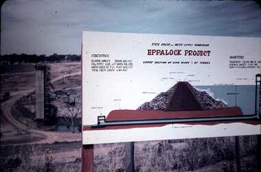
Slide - DAVID MCDONALD COLLECTION: EPPALOCK. CONSTRUCTION, c1960
... tower in the background, project board for the public to view with information about the ''Eppalock Project''. Statistics and diagram of the cross section view of the dam wall, showing the cavity in the wall and the pipeline under the wall. Markings: Eppalock Dam Observation...tower in the background, project board for the public to view with information about the ''Eppalock Project''. Statistics and diagram of the cross section view of the dam wall, showing the cavity in the wall and the pipeline under the wall. Markings: Eppalock Dam Observation ...Eppalock. Construction. Water tower in the background, project board for the public to view with information about the ''Eppalock Project''. Statistics and diagram of the cross section view of the dam wall, showing the cavity in the wall and the pipeline under the wall. Markings: Eppalock Dam Observation Point Board.Agfacolorcivil engineering, water supply, eppalock -
 Bendigo Historical Society Inc.
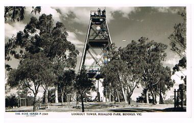
Postcard - LOOKOUT TOWER, ROSALIND PARK, BENDIGO
... Postcard, black and white: Poppet head on top of Rosalind Tower, surrounded by trees. People on observation deck. On bottom : The Rose Series P 2849, Lookout Tower, Rosalind Park, Bendigo, Vic....History House 11 Mackenzie Street Bendigo goldfields BENDIGO Buildings lookout tower rosalind park Bendigo Rosalind Park Lookout tower Postcard, black and white: Poppet head on top of Rosalind Tower, surrounded by trees. People on observation deck. On bottom : The Rose Series P 2849, Lookout Tower, Rosalind Park, Bendigo, Vic. ...Postcard, black and white: Poppet head on top of Rosalind Tower, surrounded by trees. People on observation deck. On bottom : The Rose Series P 2849, Lookout Tower, Rosalind Park, Bendigo, Vic.bendigo, buildings, lookout tower, rosalind park, bendigo, rosalind park, lookout tower -
 Narre Warren and District Family History Group
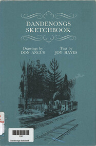
Book, Joy Hayes et al, Dandenongs Sketchbook, 1970
... One Tree Hill Observation Tower...Narre Warren and District Family History Group 110 High Street Berwick melbourne Dobson family grave Ferntree Gully One Tree Hill Observation Tower Puffing Billy Nobelius Nursery Emerald Various sketches from all areas of the Dandenong Ranges with descriptions beside it 62 p.; 23 cm Dandenongs Sketchbook Book Joy Hayes Don Angus Rigby ...Various sketches from all areas of the Dandenong Ranges with descriptions beside it62 p.; 23 cmnon-fictionVarious sketches from all areas of the Dandenong Ranges with descriptions beside itdobson family grave ferntree gully, one tree hill observation tower, puffing billy, nobelius nursery emerald -
 Lakes Entrance Historical Society
Postcard - Lookout tower Jemmy's Point, 1940
... Black and white small format postcard of the timber observation lookout at Jemmy's Point, Lakes Entrance, Victoria, showing the updated and safer steps from ground to observation deck, with fenced landing at halfway point. Old log and seat still nearby, signal beacon on steel tower a short distance away....Lakes Entrance Historical Society 4 Marine Parade Lakes Entrance gippsland Historic Sites Navigation Fences Black and white small format postcard of the timber observation lookout at Jemmy's Point, Lakes Entrance, Victoria, showing the updated and safer steps from ground to observation deck, with fenced landing at halfway point. Old log and seat still nearby, signal beacon on steel tower a short distance away. ...Black and white small format postcard of the timber observation lookout at Jemmy's Point, Lakes Entrance, Victoria, showing the updated and safer steps from ground to observation deck, with fenced landing at halfway point. Old log and seat still nearby, signal beacon on steel tower a short distance away.historic sites, navigation, fences -
 Lakes Entrance Historical Society
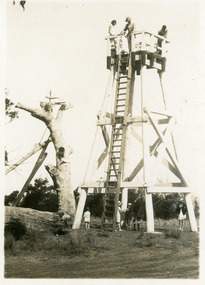
Photograph - Observation tower, 1944
... Observation tower...Lakes Entrance Historical Society 4 Marine Parade Lakes Entrance gippsland One other photography Observation Volunteering WW2 Black and white photograph of the Volunteer Air Observors Corp tower on Esplanade Lakes Entrance Victoria Photograph Observation tower ...One other photographyBlack and white photograph of the Volunteer Air Observors Corp tower on Esplanade Lakes Entrance Victoriaobservation, volunteering, ww2 -
 Lakes Entrance Historical Society
Postcard - Lookout tower Jemmys Point, 1929
... Lakes Entrance Historical Society 4 Marine Parade Lakes Entrance gippsland Also, two enlargements, 10 x 15 cm, and one enlargement 17 x 25 cm, all purchased Historic Sites Navigation On reverse, 'LookOut Jemmys Point, Lakes Entrance' Small format postcard showing the first observation lookout erected on Jemmy's Point, Lakes Entrance, Victoria, showing a timber structure about 30 feet high with a fenced platform on top, narrow ladder leading straight to top from ground. Five people on ground, three on platform. Old Lookout Tree standing in background. Postcard Lookout tower ...Also, two enlargements, 10 x 15 cm, and one enlargement 17 x 25 cm, all purchasedSmall format postcard showing the first observation lookout erected on Jemmy's Point, Lakes Entrance, Victoria, showing a timber structure about 30 feet high with a fenced platform on top, narrow ladder leading straight to top from ground. Five people on ground, three on platform. Old Lookout Tree standing in background.On reverse, 'LookOut Jemmys Point, Lakes Entrance'historic sites, navigation -
 Lakes Entrance Historical Society
Photograph - Air Observer Tower Lakes Entrance 1944, 1944
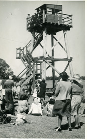
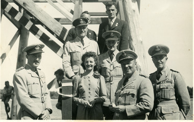
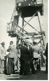
... Named in photo - Group Captain W Garing, Wing Commander D Kingwell, Squadron Leader W Leggett, Flight Lt C Patterson, Squadron Leader L Matheson, Miss J F Muir, Mr Frank Dugan, Mr D Williams Historic Sites WW2 Observation Officials Black and white photograph taken of the officials at the opening of the Volunteer Air Observors Corp tower on Esplanade, Lakes Entrance Victoria Photograph Air Observer Tower Lakes Entrance 1944 ...Named in photo - Group Captain W Garing, Wing Commander D Kingwell, Squadron Leader W Leggett, Flight Lt C Patterson, Squadron Leader L Matheson, Miss J F Muir, Mr Frank Dugan, Mr D WilliamsBlack and white photograph taken of the officials at the opening of the Volunteer Air Observors Corp tower on Esplanade, Lakes Entrance Victoriahistoric sites, ww2, observation, officials -
 Lakes Entrance Historical Society
Photograph - Volunteer Air Observers Corp tower on Esplanade, Lakes Entrance Victoria 1944
... Black and white photograph of the Volunteer Air Observors Corp tower on Esplanade showing timber tower with steps broken by two landings leading to fenced square deck on top, small observation hut built on deck, onlookers around tower and beside roadway. ...Tower was demolished 1972.|Also two other photographs similar Observation World War 1939 - 1945 Volunteering Black and white photograph of the Volunteer Air Observors Corp tower on Esplanade showing timber tower with steps broken by two landings leading to fenced square deck on top, small observation hut built on deck, onlookers around tower and beside roadway. ...Date made February 1944 Prior to the tower being built VAOC activities took place at the Post Office Jetty. Tower was demolished 1972.|Also two other photographs similarBlack and white photograph of the Volunteer Air Observors Corp tower on Esplanade showing timber tower with steps broken by two landings leading to fenced square deck on top, small observation hut built on deck, onlookers around tower and beside roadway. Lakes Entrance Victoriaobservation, world war 1939 - 1945, volunteering -
 Department of Energy, Environment and Climate Action
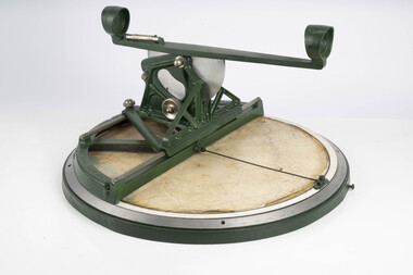
Fire Finder
... observation posts, were often just a clearing on a hill or a vantage point, whereas firetowers were definite structures. Many were established by the Forests Commission Victoria (FCV) in the 1920s, but the network was expanded rapidly in response to recommendations of the Stretton Royal Commission after the 1939 Black Friday bushfires. When a fire or smoke was spotted from the tower...observation posts, were often just a clearing on a hill or a vantage point, whereas firetowers were definite structures. Many were established by the Forests Commission Victoria (FCV) in the 1920s, but the network was expanded rapidly in response to recommendations of the Stretton Royal Commission after the 1939 Black Friday bushfires. When a fire or smoke was spotted from the tower ...Victoria once had well over one hundred fire lookouts and firetowers. Fire lookouts, or observation posts, were often just a clearing on a hill or a vantage point, whereas firetowers were definite structures. Many were established by the Forests Commission Victoria (FCV) in the 1920s, but the network was expanded rapidly in response to recommendations of the Stretton Royal Commission after the 1939 Black Friday bushfires. When a fire or smoke was spotted from the tower a bearing was taken with the alidade and radioed or telephoned into the district office. It was then cross referenced with bearings from other towers on a large wall map to give a "fix" on the fire location. Alidades and telescopes were used in the post war period but were replaced with a much simpler map table and reference string suspended from the centre of the tower cabin. This "Fire Finder" was used in Canadian fire towers to identify the location of wildfires. The unique design was first developed by the British Columbia Forest Service (BCFS) in the early 1950s. Close examination of the map indicates that this particular Fire Finder may have been once used at Bluejoint Mountain lookout in Granby Provincial Park. This Fire Finder was a gift to Barry (Rocky) Marsden from the British Columbia Forest Service in the late 1980s in recognition of the close relationships that had been forged with the staff at the Altona Workshops over many decades. Fire Finders were originally painted black but this one was repainted green after it arrived at Altona. The BC Forest Service had a large facility where they manufactured Fire Finders and many other items of equipment, but in the 1980s it was shut down. Heavy cast iron circular object with a paper topographic map mounted on it. The metal dial and ruler works similar to a compass. The sight tube is used to determine the bearing and elevation of the fire on the map. This Fire Finder also sometimes known as an Alidade. Its a different design from the Osborne Fire Finder widely used in North American fire lookouts from the 1920s. British Columbia Forest Service. Model 62A. Serial Number 6308.bushfire -
 Department of Energy, Environment and Climate Action
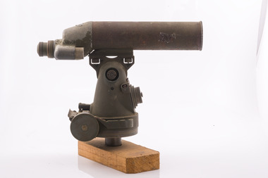
Telescope used in FCV fire towers - ex military, c 1940s
... observation posts, were often just a clearing on a hill or a vantage point, whereas firetowers were definite structures. Many were established by the Forests Commission Victoria (FCV) in the 1920s, but the network was expanded rapidly in response to recommendations of the Stretton Royal Commission after the 1939 Black Friday bushfires. When a fire or smoke was spotted from the tower...observation posts, were often just a clearing on a hill or a vantage point, whereas firetowers were definite structures. Many were established by the Forests Commission Victoria (FCV) in the 1920s, but the network was expanded rapidly in response to recommendations of the Stretton Royal Commission after the 1939 Black Friday bushfires. When a fire or smoke was spotted from the tower ...Victoria once had well over one hundred fire lookouts and firetowers. Fire lookouts, or observation posts, were often just a clearing on a hill or a vantage point, whereas firetowers were definite structures. Many were established by the Forests Commission Victoria (FCV) in the 1920s, but the network was expanded rapidly in response to recommendations of the Stretton Royal Commission after the 1939 Black Friday bushfires. When a fire or smoke was spotted from the tower a bearing was taken with the alidade and radioed or telephoned into the district office. It was then cross referenced with bearings from other towers on a large wall map to give a "fix" on the fire location Alidades and telescopes were used in the post war period but were replaced with a much simpler map table and reference string suspended from the centre of the tower cabin.Uncommon usageTelescope used in fire towers Ex military Kern Company NY Argus made in USA Adjustment lens, dials and focus ring Small spirit levelbushfire, forests commission victoria (fcv)