Showing 58 items matching "old coach road"
-
 Mt Dandenong & District Historical Society Inc.
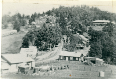
Photograph, Kalorama Gap in 1927, 1927
... ...old coach road...CRB Main Road, Ridge Road, Old Coach Road and barber's Road also visible. This photograph has a detailed inscription on the back handwritten by John Lundy-Clarke in 1974. ...Showing Jeeves Garage Fiveways Cafe Nicholls Store 'Mountjoy' C.R.B Main Rd Center Ridge Road Right of Center Old Coach Road lower right corner behind shed Barber's Road going left through clump of trees in center ...Farndons Community Hall 42 Falls Road Mt Dandenong yarra-valley-and-the-dandenong-ranges kalorama gap kalorama fiveways fiveways cafe jeeves jeeves garage garage nicholls store mountjoy barbers road old coach road ridge road main road crb road The Kalorama Gap in 1927. ...View of the Kalorama Gap (FiveWays) in 1927. Buildings shown are Jeeves' Garage, FiveWays Cafe, Nicholl's Store, Mountjoy. CRB Main Road, Ridge Road, Old Coach Road and barber's Road also visible. This photograph has a detailed inscription on the back handwritten by John Lundy-Clarke in 1974. The Kalorama Gap in 1927. Showing Jeeves Garage Fiveways Cafe Nicholls Store 'Mountjoy' C.R.B Main Rd Center Ridge Road Right of Center Old Coach Road lower right corner behind shed Barber's Road going left through clump of trees in center kalorama gap, kalorama, fiveways, fiveways cafe, jeeves, jeeves garage, garage, nicholls store, mountjoy, barbers road, old coach road, ridge road, main road, crb road -
 Mt Dandenong & District Historical Society Inc.
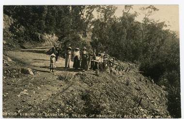
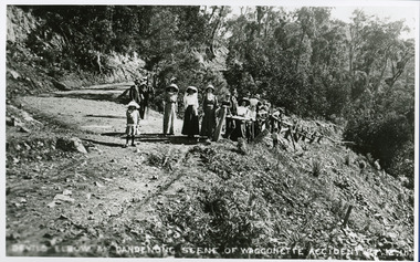
Photograph, Devils Elbow Mt. Dandenong Scene of Waggonette Disaster 27.12.1911, 1911
... ...Coach Road...old...Original postcard showing a group of about 20 people surveying the scene of the Waggonette Disaster that occurred on the Coach Road at Devils Elbow on 27/12/1911. The accident occurred at Devil's Elbow where now the Old Coach Road and Jasper Road meet at a cliff face. ...The accident occurred at Devil's Elbow where now the Old Coach Road and Jasper Road meet at a cliff face. ...Original postcard showing a group of about 20 people surveying the scene of the Waggonette Disaster that occurred on the Coach Road at Devils Elbow on 27/12/1911. The accident occurred at Devil's Elbow where now the Old Coach Road and Jasper Road meet at a cliff face. John Lundy-Clarke made a ballad about the mishap. The waggonnette was returning from an excursion to the Brooklyn Guest House in Montrose. The horses were killed and passengers presumably injured (a doctor attended). See 'The Brooklyn Dray"On front of postcard: DEVILS ELBOW MT DANDENONG SCENE OF WAGGONETTE ACCIDENT 27.12.1911wagonette, wagon, accident, disaster, devil's elbow, devils elbow, john lundy-clarke, ballad, coach road, old coach road -
 Mt Dandenong & District Historical Society Inc.
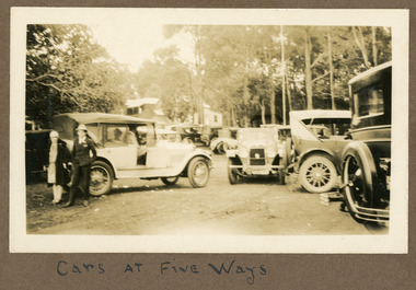
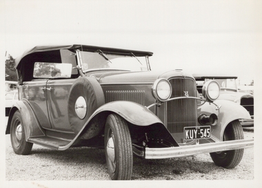
Photograph
... ...Old Coach Road...The cars appear to be parked on Old Coach Road with the FiveWays Cafe and the back of the Methodist Church in the background. ...The cars appear to be parked on Old Coach Road with the FiveWays Cafe and the back of the Methodist Church in the background. ...The photograph is taken at Five Ways intersection at Kalorama in the late 1920s. The cars appear to be parked on Old Coach Road with the FiveWays Cafe and the back of the Methodist Church in the background. The photograph is from the album of Ivy Child. Ivy May Child (1910 – 1989) was the daughter of Arthur Edward (Ted) Child (1878 – 1964) and Ethel May Madden (1888 – 1970). Ted Child was the son of Matthew Francis Child (1839 – 1933) and Martha Jeeves (1857 – 1926). He was the grandson of one of the early pioneers Francis Child. Ivy grew up on the family property on Childs Road and took many photographs. Most of these are glued into her photo album. The album covered the years from c1927 – 1932. Ivy married Henry William Burgess (1906 – 1968) in 1944. The photographs remain in their original state in the album with individual copies made. Sepia photograph showing seven or more old cars parked at FiveWays in Kalorama. A man and woman are in the foreground leaning on the back of a car.Written below photograph in album: CARS AT FIVE WAYSfive ways, fiveways, kalorama, cars, automobiles, methodist church, old coach road, ivy child, ivy may child -
 Mt Dandenong & District Historical Society Inc.
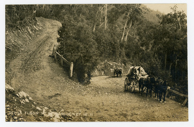
Photograph, Devils Elbow Mt Dandenong 27.12.1911, 1911
... ...Coach Road...old...Farndons Community Hall 42 Falls Road Mt Dandenong yarra-valley-and-the-dandenong-ranges Wagon Wagonette Devil's Elbow Devils Elbow Coach Road old coach road mt dandenong On front of postcard: DEVILS ELBOW MT DANDENONG 27.12.1911 Original postcard showing two wagons coming up the hill to round the Devil's Elbow, scene of a wagon disaster where a wagon and horses went over the side on December 27th 1911. ...Original postcard showing two wagons coming up the hill to round the Devil's Elbow, scene of a wagon disaster where a wagon and horses went over the side on December 27th 1911. The first wagon is pulled by three horses and the second one horse with a man leading it.On front of postcard: DEVILS ELBOW MT DANDENONG 27.12.1911wagon, wagonette, devil's elbow, devils elbow, coach road, old coach road, mt dandenong -
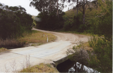 Lakes Entrance Historical Society
Photograph - Bunga Rd. Lakes Entrance 2008, Wendy Price
... Colour photograph of old Bunga Road crossing this was part of the old coach road which went from Lakes Entrance via Lake Tyers to Orbost, Lakes Entrance Victoria...This photograph was used in the 150 year display Lakes Entrance 1858 to 2008 paired with image number 03728 as the after picture Roads and Streets Development Colour photograph of old Bunga Road crossing this was part of the old coach road which went from Lakes Entrance via Lake Tyers to Orbost, Lakes Entrance Victoria Photograph Bunga Rd. ...This photograph was used in the 150 year display Lakes Entrance 1858 to 2008 paired with image number 03728 as the after pictureColour photograph of old Bunga Road crossing this was part of the old coach road which went from Lakes Entrance via Lake Tyers to Orbost, Lakes Entrance Victoriaroads and streets, development -
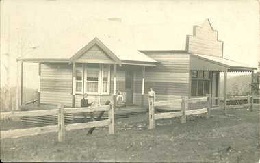 Mt Dandenong & District Historical Society Inc.
Photograph, Mt Dandenong Store, c1912
... Black & white photograph of Dower's house and shop built on the corner of Old Coach Road and Farndons Road in Mt Dandenong. ...Dower Will Dower Mt Dandenong Mt Dandenong Store Mt Dandenong Post Office Mount Dandenong Post Office Lil Badenhop Black & white photograph of Dower's house and shop built on the corner of Old Coach Road and Farndons Road in Mt Dandenong. ...The Mt Dandenong Post Office & Store was originally built by Will Dower. The house and shop was built in 1912 and staffed by Ruby and Ada Dower. It became the Post Office in 1917 when Lil Badenhop sold her business following the death of her daughter Myrtle. The Post Office and Store closed in 1926 when the new premises opened on the Main Road.Black & white photograph of Dower's house and shop built on the corner of Old Coach Road and Farndons Road in Mt Dandenong. A man, woman and two children are in the foreground. Donated as a jpeg digital image.dower, will dower, mt dandenong, mt dandenong store, mt dandenong post office, mount dandenong post office, lil badenhop -
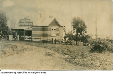 Mt Dandenong & District Historical Society Inc.
Photograph, Mt Dandenong Post Office Near Blythes Road
... Black and white photograph of Dower's house and shop built on the corner of Old Coach Road and Farndons Road in Mt Dandenong. ...Dower Will Dower Mt Dandenong Mt Dandenong School Mt Dandenong Store Mt Dandenong Post Office Ruby Dower Ada Dower Black and white photograph of Dower's house and shop built on the corner of Old Coach Road and Farndons Road in Mt Dandenong. ...The Mt Dandenong Post Office & Store was originally built by Will Dower. The house and shop was built in 1912 and staffed by Ruby and Ada Dower. It became the Post Office in 1917 when Lil Badenhop sold her business following the death of her daughter Myrtle. The Post Office and Store closed in 1926 when the new premises opened on the Main Road.Black and white photograph of Dower's house and shop built on the corner of Old Coach Road and Farndons Road in Mt Dandenong. A boy with a bicycle can be seen at the LHS edge of the photograph and the Mt Dandenong State School building directly behind the shop.dower, will dower, mt dandenong, mt dandenong school, mt dandenong store, mt dandenong post office, ruby dower, ada dower -
 Lakes Entrance Historical Society
Photograph - Old Bunga Rd. Lakes Entrance 1927, c1927
... This was the old coach road to Orbost which went from Lakes Entrance to Orbost via Lake Tyers....This was the old coach road to Orbost which went from Lakes Entrance to Orbost via Lake Tyers. ...This was the old coach road to Orbost which went from Lakes Entrance to Orbost via Lake Tyers.Black and White photograph of old Bunga Road crossing, Lake Tyers.roads and streets, development -
 Mt Dandenong & District Historical Society Inc.
Photograph, Devil's Elbow at Mt Dandenong Scene of Waggonette Accident 27.12.11, 1911
... Accident occurred at Devil's Elbow where now the Old Coach Road and Jasper Road meet at a cliff face. ...Farndons Community Hall 42 Falls Road Mt Dandenong yarra-valley-and-the-dandenong-ranges John Lundy-Clarke Kalorama Devil's Elbow Wagonette Accident occurred at Devil's Elbow where now the Old Coach Road and Jasper Road meet at a cliff face. ...Accident occurred at Devil's Elbow where now the Old Coach Road and Jasper Road meet at a cliff face. John Lundy-Clarke made a ballad about the mishap. The waggonnette was returning from an excursion to the Brooklyn Guest House in Montrose. The horses were killed and passengers presumably injured (a doctor attended). See 'The Brooklyn Dray".john lundy-clarke, kalorama, devil's elbow, wagonette -
 Mt Dandenong & District Historical Society Inc.
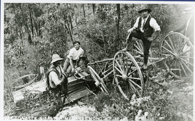
Photograph, The Wagonette Disaster 27th December 1911, 1911
... This accident occurred at Devil's Elbow where now the Old Coach Road and Jasper Road meet at a cliff face. ...Farndons Community Hall 42 Falls Road Mt Dandenong yarra-valley-and-the-dandenong-ranges devil's elbow kalorama john lundy-clarke wagonette This accident occurred at Devil's Elbow where now the Old Coach Road and Jasper Road meet at a cliff face. ...This accident occurred at Devil's Elbow where now the Old Coach Road and Jasper Road meet at a cliff face. John Lundy-Clarke wrote a ballad about the mishap, probably combining fact and fancy. The wagonette was returning from an excursion to the Brooklyn Guest House in Montrose. Apparently only the horses were killed in the accident. See 'The Brooklyn Dray". The photograph shows local men inspecting the wreckage. (Not passengers as they were injured).devil's elbow, kalorama, john lundy-clarke, wagonette -
 Mt Dandenong & District Historical Society Inc.
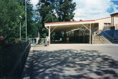
Photograph, Mount Dandenong Primary School 1997, 1997
... The first Mt Dandenong State School opened in a shed on the property of William Ferguson on the corner of Blythe and Old Coach Roads. The first teacher was Miss Ethel Gruber who opened the school on May 11th, 1897. ...Farndons Community Hall 42 Falls Road Mt Dandenong yarra-valley-and-the-dandenong-ranges The first Mt Dandenong State School opened in a shed on the property of William Ferguson on the corner of Blythe and Old Coach Roads. The first teacher was Miss Ethel Gruber who opened the school on May 11th, 1897. ...The first Mt Dandenong State School opened in a shed on the property of William Ferguson on the corner of Blythe and Old Coach Roads. The first teacher was Miss Ethel Gruber who opened the school on May 11th, 1897. It wasn’t until 1901 that the school shifted over the road into an old school building that was moved up to the new site from Ringwood. All the buildings were demolished to make way for a new school that opened in 1991. Looking across from asphalted area to the 'undercover area' November 1997.mount dandenong, mt dandenong school -
 Mt Dandenong & District Historical Society Inc.
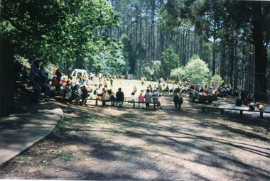
Photograph, Mount Dandenong Primary School 1997, 1997
... The first Mt Dandenong State School opened in a shed on the property of William Ferguson on the corner of Blythe and Old Coach Roads. The first teacher was Miss Ethel Gruber who opened the school on May 11th, 1897. ...The first Mt Dandenong State School opened in a shed on the property of William Ferguson on the corner of Blythe and Old Coach Roads. The first teacher was Miss Ethel Gruber who opened the school on May 11th, 1897. ...1997 was the school's centenary year. The first Mt Dandenong State School opened in a shed on the property of William Ferguson on the corner of Blythe and Old Coach Roads. The first teacher was Miss Ethel Gruber who opened the school on May 11th, 1897. It wasn’t until 1901 that the school shifted over the road into an old school building that was moved up to the new site from Ringwood. All the buildings were demolished to make way for a new school that opened in 1991. View of Sports Day November 1997 with parents watching and children participating.mount dandenong, mt dandenong school, centenary -
 Mt Dandenong & District Historical Society Inc.
Photograph, Mount Dandenong Primary School 1997, 1997
... The first Mt Dandenong State School opened in a shed on the property of William Ferguson on the corner of Blythe and Old Coach Roads. The first teacher was Miss Ethel Gruber who opened the school on May 11th, 1897. ...The first Mt Dandenong State School opened in a shed on the property of William Ferguson on the corner of Blythe and Old Coach Roads. The first teacher was Miss Ethel Gruber who opened the school on May 11th, 1897. ...1997 was the Centenary Year of the school. The first Mt Dandenong State School opened in a shed on the property of William Ferguson on the corner of Blythe and Old Coach Roads. The first teacher was Miss Ethel Gruber who opened the school on May 11th, 1897. It wasn’t until 1901 that the school shifted over the road into an old school building that was moved up to the new site from Ringwood. All the buildings were demolished to make way for a new school that opened in 1991. Students playing on the basketball/tennis court below the school oval in 1997mount dandenong, mt dandenong school -
 Mt Dandenong & District Historical Society Inc.
Photograph, Mount Dandenong Primary School 1997, 1997
... The first Mt Dandenong State School opened in a shed on the property of William Ferguson on the corner of Blythe and Old Coach Roads. The first teacher was Miss Ethel Gruber who opened the school on May 11th, 1897. ...Farndons Community Hall 42 Falls Road Mt Dandenong yarra-valley-and-the-dandenong-ranges The first Mt Dandenong State School opened in a shed on the property of William Ferguson on the corner of Blythe and Old Coach Roads. The first teacher was Miss Ethel Gruber who opened the school on May 11th, 1897. ...The first Mt Dandenong State School opened in a shed on the property of William Ferguson on the corner of Blythe and Old Coach Roads. The first teacher was Miss Ethel Gruber who opened the school on May 11th, 1897. It wasn’t until 1901 that the school shifted over the road into an old school building that was moved up to the new site from Ringwood. All the old buildings were demolished to make way for a new school that opened in 1991. There are many old, European trees that were planted in the grounds during Arbor Days. Students standing at base of large Sequoia Tree in grounds of school in 1997, centenary year.mount dandenong, mt dandenong school, sequoia, centenary, trees -
 Mt Dandenong & District Historical Society Inc.
Photograph, Mt Dandenong Primary School in Snow 1995, 1995
... The first Mt Dandenong State School opened in a shed on the property of William Ferguson on the corner of Blythe and Old Coach Roads. The first teacher was Miss Ethel Gruber who opened the school on May 11th, 1897. ...Farndons Community Hall 42 Falls Road Mt Dandenong yarra-valley-and-the-dandenong-ranges The first Mt Dandenong State School opened in a shed on the property of William Ferguson on the corner of Blythe and Old Coach Roads. The first teacher was Miss Ethel Gruber who opened the school on May 11th, 1897. ...The first Mt Dandenong State School opened in a shed on the property of William Ferguson on the corner of Blythe and Old Coach Roads. The first teacher was Miss Ethel Gruber who opened the school on May 11th, 1897. It wasn’t until 1901 that the school shifted over the road into an old school building that was moved up to the new site from Ringwood. All the buildings were demolished to make way for a new school that opened in 1991. Up until the later 2000s snow fell at the school several times a year. Three children playing in snow at the front of Mt Dandenong Primary School 5th September 1995. The snow lasted three days.mt dandenong school, snow, mt dandenong -
 Mt Dandenong & District Historical Society Inc.
Photograph, Farringdon Road
... This would be a very early photograph in the history of the road and shows a Jeeves coach travelling along the new road at the base of Farringdon Road in Kalorama. Ellis Jeeves established the coach sevice between Kalorama and Croydon in 1904. It originally travelled down the Old...This would be a very early photograph in the history of the road and shows a Jeeves coach travelling along the new road at the base of Farringdon Road in Kalorama. Ellis Jeeves established the coach sevice between Kalorama and Croydon in 1904. It originally travelled down the Old ...Mt Dandenong Road (CRB Road, New Road, Main Road) was begun in the early 1920s and completed c1926. This would be a very early photograph in the history of the road and shows a Jeeves coach travelling along the new road at the base of Farringdon Road in Kalorama. Ellis Jeeves established the coach sevice between Kalorama and Croydon in 1904. It originally travelled down the Old Coach Road. John Lundy-Clarke grew up in the Kalorama/Mt Dandenong area and later in life (1972-74) began to write a comprehensive history of the area working from an original settlement map in an effort to cover all areas.Black and white photograph looking down an unmade road showing a coach travelling along another unmade road at the bottom. Roads are tree lined. handwritten inscription on reverse by John Lundy-Clarke.1920 Farringdon Road, looking at Jeeves Coach on Mt Dandenong Road.mt dandenong road, crb road, farringdon road, jeeves, ellis jeeves, coach, mt dandenong tourist road, kalorama -
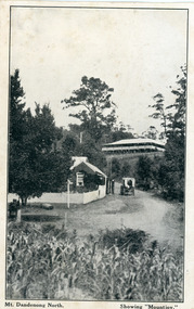 Mt Dandenong & District Historical Society Inc.
Photograph, Mt Dandenong North. Showing "Mountjoy"
... The Tourist Road does not yet exist. Old Coach Road comes into the picture from the right and the horse and cart is heading up Ridge Road. ...The Tourist Road does not yet exist. Old Coach Road comes into the picture from the right and the horse and cart is heading up Ridge Road. ...The building with the white picket fence is the Beulah Tea Gardens opened by Eliza Hand c1904 at The Gap (now FiveWays). The building is still operating as a cafe. The Tourist Road does not yet exist. Old Coach Road comes into the picture from the right and the horse and cart is heading up Ridge Road. The elm trees can be seen on the left. The building up on the hill is the Mountjoy Guest House. ‘Mountjoy’ was built by the Paynter family in 1905. It had fourteen bedrooms, a dining room and sitting room, kitchen with a big wood burning range and verandahs on three sides. There were commanding views of the eastern ranges and the city to the west. Ellis Jeeves purchased ‘Mountjoy’ in 1908 and it soon became a popular tourist destination, the coach yards making it a centre of the district. ‘Mountjoy’ is a central feature of many photographs of Kalorama in the 1900s. The building burned down in 1975. Mt. Dandenong North was renamed Kalorama in 1926.Black and white postcard showing a horse and cart on road between two buildings.On front ; Mt. Dandenong North. Showing "Mountjoy."postcard, mountjoy, guest house, beulah tea room, beulah, mt dandenong north, kalorama -
 Mt Dandenong & District Historical Society Inc.
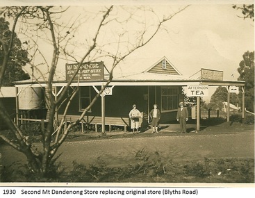
Photograph, Mt Dandenong Store, 1930
... Image shows the Mt Dandenong Store and Post Office that replaced the former Post office and Store that was located on the corner of Old Coach and Farndons Roads. The store relocated following the opening of the new Main Road in 1926. ...Farndons Community Hall 42 Falls Road Mt Dandenong yarra-valley-and-the-dandenong-ranges Image shows the Mt Dandenong Store and Post Office that replaced the former Post office and Store that was located on the corner of Old Coach and Farndons Roads. ...Image shows the Mt Dandenong Store and Post Office that replaced the former Post office and Store that was located on the corner of Old Coach and Farndons Roads. The store relocated following the opening of the new Main Road in 1926. The store pictured was on the corner of Helen Street and the Main Road. The image was taken in 1930. The photograph was taken by a member of the Dower family.Donated as a jpeg digital image that shows the Mt Dandenong Store on the corner of Helen Street and the Main Road in 1930. Two women and a man are standing at the front. Signs advertising the Store & Post Office, Age and Argus are clearly visible on top of the verandah.Front of image: 1930 Second Mt Dandenong Store replacing original store (Blyths Road)mt dandenong, post office, store, mt dandenong store, main road -
 Glen Eira Historical Society
Album - Album page, Glen Huntly Road, Circa 1972
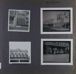
... older and from unknown sources. All photographs are black and white except where stated, with 386 photographs over 198 pages. 376 Glen Huntly Road is a contributory building to HO72 - Elsternwick Estate and Environs, City of Glen Eira. trevor hart glen huntly road elsternwick shops streetscapes vintage cars carriages and coaches glenhuntly road Hand written: Glen Huntly Road [top right] / 376 GLENHUNTLY ROAD [written in blue pen on the bottom edge of the top left photo] / 216-218 Glen Huntly Rd [under bottom left photo] / 64 [bottom right] Page 64 of Photograph Album with four photographs of different properties on Glen Huntly Road - 2 in portrait mode and 2 in portrait photographs of photographs. ...This photograph is part of the Caulfield Historical Album 1972. This album was created in approximately 1972 as part of a project by the Caulfield Historical Society to assist in identifying buildings worthy of preservation. The album is related to a Survey the Caulfield Historical Society developed in collaboration with the National Trust of Australia (Victoria) and Caulfield City Council to identify historic buildings within the City of Caulfield that warranted the protection of a National Trust Classification. Principal photographer thought to be Trevor Hart, member of Caulfield Historical Society. Most photographs were taken between 1966-1972 with a small number of photographs being older and from unknown sources. All photographs are black and white except where stated, with 386 photographs over 198 pages. 376 Glen Huntly Road is a contributory building to HO72 - Elsternwick Estate and Environs, City of Glen Eira.Page 64 of Photograph Album with four photographs of different properties on Glen Huntly Road - 2 in portrait mode and 2 in portrait photographs of photographs.Hand written: Glen Huntly Road [top right] / 376 GLENHUNTLY ROAD [written in blue pen on the bottom edge of the top left photo] / 216-218 Glen Huntly Rd [under bottom left photo] / 64 [bottom right] trevor hart, glen huntly road, elsternwick, shops, streetscapes, vintage cars, carriages and coaches, glenhuntly road -
 Greensborough Historical Society
Photograph - Digital image, Stubley's Furniture, 1958c
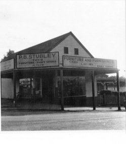
... old site to keep the business operating. It was completed in 1951. The Group expanded into other areas such as this Furniture store. [Syd Thompson Fruit Shop was here in early 1950s, Syd lived in the house at back. He coached Boxing]. This became the Welkay Store in the 1960's and owned by Walter Kenyon. The Welkay store moved opposite to 100 Main Road...Road Lower Plenty Lower Plenty melbourne Stubley's Furniture Store late 1950s. The Stubley Group began in 1946 when Purcell Stubley purchased a site with petrol bowsers in Main Street from 'Snowy' Jessop. In 1948 Purcell began building the new Stubley Motors, working round the old site to keep the business operating. It was completed in 1951. The Group expanded into other areas such as this Furniture store. [Syd Thompson Fruit Shop was here in early 1950s, Syd lived in the house at back. He coached ...Stubley's Furniture Store late 1950s. The Stubley Group began in 1946 when Purcell Stubley purchased a site with petrol bowsers in Main Street from 'Snowy' Jessop. In 1948 Purcell began building the new Stubley Motors, working round the old site to keep the business operating. It was completed in 1951. The Group expanded into other areas such as this Furniture store. [Syd Thompson Fruit Shop was here in early 1950s, Syd lived in the house at back. He coached Boxing]. This became the Welkay Store in the 1960's and owned by Walter Kenyon. The Welkay store moved opposite to 100 Main Road on 6/9/1966, ref: Diamond Valley News Page 9. Soon after the store would have been demolished to make way for 'The Valley Building' still on the site in 2018.Digital copy of black and white photographpurcell stubley, stubley motors, stubley group greensborough -
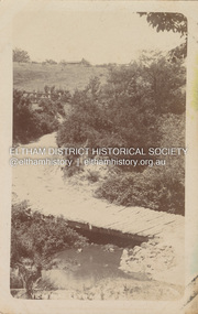 Eltham District Historical Society Inc
Postcard - Photograph postcard, Old Bridge, Kaylock's Crossing, Brougham Street, Eltham, c.1912
... Kaylock's Bridge formed part of the original coach road to Eltham and in 1922 was described as an "old rustic bridge". ...Kaylock's Bridge formed part of the original coach road to Eltham and in 1922 was described as an "old rustic bridge". ...Date estimated to be circa 1912 based on the style of printing on the reverse of the card - Kodak Austral paper for real photo postcards, the paper was manufactured c.1908-1914 (See also POSTCARDS ON KODAK PAPER - IS IT POSSIBLE TO "DATE" THEM? http://tps.org.au/bb/viewtopic.php?t=115) Brougham Street was created in Josiah Holloway's 1851 subdivision of Little Eltham. It was one of several east-west streets shown on the subdivision plan as crossing the Diamond Creek. The western part was named Wellington Street on the subdivision plan but was later changed to conform with the name of the eastern part as acknowledgement of the continuity of the street. It is not known when the first bridge was constructed in Brougham Street however it was certainly mentioned at Council’s meeting of 2 June 1884 as being in a dangerous state of repair. This photo (c.1895) of an old bridge shows a very low-level simple log girder bridge crossing the creek at a right angle and so the approaches involved bends in the road alignment. This bridge was generally known as Kaylocks Bridge or Kaylock’s Crossing after the owner of the adjoining land. It was most likely built from around the mid-1850s, or a crossing of some fashion established as Richard George Kaylock, butcher of Little Eltham and his wife Emily Ann settled there in 1854. His property was in Wellington Street (now Brougham Street) and apparently extended across the Diamond Creek. The land on the western side of the creek was farmed, the house being on the eastern side. Kaylock's Bridge formed part of the original coach road to Eltham and in 1922 was described as an "old rustic bridge". Its low level and insubstantial construction made it susceptible to flood damage, necessitating frequent closures until repairs could be carried out. In September 1922, Council called for tenders for a new timber bridge to be constructed at Kaylock’s crossing. An engineering assessment carried out for the Council by Macleod Consulting at the time of the replacement suggested that the construction details indicate that it was in the 1900s, however this dating could possibly have been the result of numerous repairs undertaken over the years to flood damage. The tender was awarded to Mr Weller of Kangaroo Ground who commenced work in February 1923 on a higher-level timber trestle bridge. Work was slowed due to illness of the contractor and the accidental death of a man in March 1923 following the collapse of the bank after he had jumped into a hole that had just been blasted. The bridge was completed around July 1923 at which point the old structure was pulled up, marking what was described in the ‘Advertiser’ newspaper as the passing of an old and well-loved landmark in the district. In April 1924 the approach to Kaylocks bridge was washed away during the heavy flooding that destroyed the Main Road bridge. The western side was repaired, and an extra span was added to the eastern side using timber from the destroyed Main Road bridge. The bridge was again severely damaged four months later in August 1924 When a lack of finances delayed repairs to the Bridge Street bridge in 1931 (also referred to as Obelisk Bridge at the time), traffic had to detour via Brougham Street for some time. Local residents feared that the Bridge Street bridge might never reopen. Kaylocks Bridge was constantly subject to damage by floods. In the 1934 flood it was submerged by two feet of water. In more recent times the bridge was again severely damaged by flooding and repairs made. A new bridge and adjoining footbridge were constructed in 2009.Digital file only Postcards scanned from the collection of Michael Aitken on loan to EDHS, 2 Sep. 2022michael aitken collection, eltham, postcards, bridge, brougham street, diamond creek (creek), kaylocks bridge, wellington street -
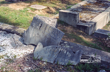 Eltham District Historical Society Inc
Negative - Photograph, Harry Gilham, Grave of Richard George, Emily Ann (nee Davis) and Edith Jane Kaylock, Eltham Cemetery, Victoria, Sep 2009
... It formed part of the original coach road to Eltham and in 1922 was described as an "old rustic bridge". ...It formed part of the original coach road to Eltham and in 1922 was described as an "old rustic bridge". ...In his early adult life, Richard Kaylock worked as a whaler (visiting California and New Zealand) and later as a drover on a large cattle station in New South Wales. In 1848 he came to Melbourne, working as a slaughterman, then settled in Eltham in 1854, his occupation thereafter being variously recorded as butcher or orchardist. He also had some experiences at Ballarat during the Eureka Rebellion. He died in 1910 at the age of 84. His obituary described him as a "striking personality" who was "brusque to a fault" and "strictly upright, expecting others to be the same". It seems from his will that he was illiterate. He is buried in Eltham Cemetery with his wife Emily. His property was in Wellington Street (now Brougham Street) and apparently extended across the Diamond Creek. The land on the western side of the creek was farmed, the house being on the eastern side. For many years the Brougham Street bridge was generally known as "Kaylock's Bridge". It formed part of the original coach road to Eltham and in 1922 was described as an "old rustic bridge". Its low level and insubstantial construction made it susceptible to flood damage, necessitating frequent closures until repairs could be carried out. The original bridge was demolished in 1923 and replaced by a "new up-to-date" one. When a lack of finances delayed repairs to the Bridge Street bridge in 1931, traffic had to detour via Brougham Street for some time. Local residents feared that the Bridge Street bridge might never reopen. In Loving Memory Of Our Dear Father & Mother R.G. and E.A. Kaylock Also E.J. Kaylock Died 21st Jan. 1927 The Eternal God Is My PledgeRoll of 35mm colour negative film, 6 stripsKodak GC 400-9eltham cemetery, gravestones, edith jane kaylock, emily ann kaylock (nee davis), richard george kaylock, brougham street bridge, kaylocks bridge -
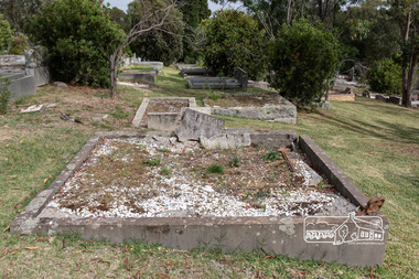 Eltham District Historical Society Inc
Photograph, Peter Pidgeon, Grave of Richard George, Emily Ann (nee Davis) and Edith Jane Kaylock, Eltham Cemetery, Victoria, 5 April 2021
... It formed part of the original coach road to Eltham and in 1922 was described as an "old rustic bridge". ...It formed part of the original coach road to Eltham and in 1922 was described as an "old rustic bridge". ...In his early adult life, Richard Kaylock worked as a whaler (visiting California and New Zealand) and later as a drover on a large cattle station in New South Wales. In 1848 he came to Melbourne, working as a slaughterman, then settled in Eltham in 1854, his occupation thereafter being variously recorded as butcher or orchardist. He also had some experiences at Ballarat during the Eureka Rebellion. He died in 1910 at the age of 84. His obituary described him as a "striking personality" who was "brusque to a fault" and "strictly upright, expecting others to be the same". It seems from his will that he was illiterate. He is buried in Eltham Cemetery with his wife Emily. His property was in Wellington Street (now Brougham Street) and apparently extended across the Diamond Creek. The land on the western side of the creek was farmed, the house being on the eastern side. For many years the Brougham Street bridge was generally known as "Kaylock's Bridge". It formed part of the original coach road to Eltham and in 1922 was described as an "old rustic bridge". Its low level and insubstantial construction made it susceptible to flood damage, necessitating frequent closures until repairs could be carried out. The original bridge was demolished in 1923 and replaced by a "new up-to-date" one. When a lack of finances delayed repairs to the Bridge Street bridge in 1931, traffic had to detour via Brougham Street for some time. Local residents feared that the Bridge Street bridge might never reopen. In Loving Memory Of Our Dear Father & Mother R.G. and E.A. Kaylock Also E.J. Kaylock Died 21st Jan. 1927 The Eternal God Is My PledgeBorn Digitaleltham cemetery, gravestones, brougham street bridge, edith jane kaylock, emily ann kaylock (nee davis), kaylocks bridge, richard george kaylock -
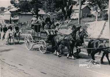 Eltham District Historical Society Inc
Photograph, Cobb and Co. Coach and horses, ERSILAC Parade, c.1960
... Black and white photograph featuring a Cobb and Co coach drawn by four horses with a full complement of passengers in period clothing. Taken near the old bakehouse at the corner of Main Road and York Street. ...Eltham District Historical Society Inc 728 Main Rd Eltham melbourne cobb and co bakery main road york street parade procession ersilac parade Horse drawn carriage Black and white photograph featuring a Cobb and Co coach drawn by four horses with a full complement of passengers in period clothing. Taken near the old ...Black and white photograph featuring a Cobb and Co coach drawn by four horses with a full complement of passengers in period clothing. Taken near the old bakehouse at the corner of Main Road and York Street. Part of a procession/parade.cobb and co, bakery, main road, york street, parade, procession, ersilac parade, horse drawn carriage -
 Ringwood and District Historical Society
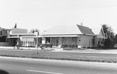
Photograph, Maroondah Highway West, Ringwood- 1969. Old Coach and Horses Hotel site
... Ringwood and District Historical Society 125A Warrandyte Road Ringwood North melbourne Written on back of photograph: "May 1969. Old Coach and Horses Hotel altered to this". ...Black and white photographWritten on back of photograph: "May 1969. Old Coach and Horses Hotel altered to this". -
 Ringwood and District Historical Society
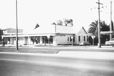
Photograph, Maroondah Highway West, Ringwood- 1978. Antique Shop on old Coach and Horses site
... Ringwood and District Historical Society 125A Warrandyte Road Ringwood North melbourne Written on back of photograph, "May 1978" Black and white photograph Maroondah Highway West, Ringwood- 1978. Antique Shop on old Coach ...Black and white photographWritten on back of photograph, "May 1978" -
 Ringwood and District Historical Society
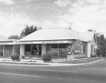
Photograph, Second Coach and Horses Hotel built 1909 used as shops today (1979)
... Ringwood and District Historical Society 125A Warrandyte Road Ringwood North melbourne Typed below photograph, "The second Coach and Horses Hotel built 1909 used as shops today (1979). Written on backing sheet, "old ...Black and white photograph of shops.Typed below photograph, "The second Coach and Horses Hotel built 1909 used as shops today (1979). Written on backing sheet, "old C & H 1909-1939" -
 Ringwood and District Historical Society
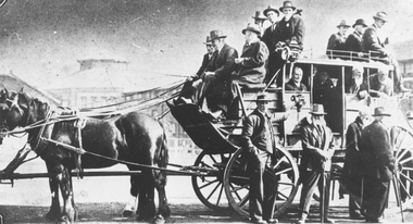
Photograph, William Hussey at a reunion of the Old Cobb & Co Drivers . c1920
... Road Ringwood North melbourne Written on back of one photograph: "Hussey 1920s". (William Hussey is marked with a cross on the photo). Written on back of other photograph: "Former Cobb & Co drivers attending a reunion of The Old Cobb & Co. Coach ...Black and white photograph (2 copies)Written on back of one photograph: "Hussey 1920s". (William Hussey is marked with a cross on the photo). Written on back of other photograph: "Former Cobb & Co drivers attending a reunion of The Old Cobb & Co. Coach Drivers held in Melbourne during the 1920's. (Refer also Hussey book- ref 4596). -
 Ringwood and District Historical Society
Photograph, First Ringwood Spring Fair at various locations. Vintage cars display in 1971
... Road Ringwood North melbourne First Ringwood Spring Fair (did they ever hold another?) at various locations. In Notlen St the band included Gendarme the famous Victoria Police horse, and the Cobb and Co coach. The balance of the Spring Pair photos were taken in the park/ gardens opposite the old ...First Ringwood Spring Fair (did they ever hold another?) at various locations. In Notlen St the band included Gendarme the famous Victoria Police horse, and the Cobb and Co coach. The balance of the Spring Pair photos were taken in the park/ gardens opposite the old Ringwood Market site. 1971. (Pam Payne) -
 Ringwood and District Historical Society
Photograph, First Ringwood Spring Fair at various locations. Playing in Charter Street Park in 1971
... Road Ringwood North melbourne First Ringwood Spring Fair (did they ever hold another?) at various locations. In Notlen St the band included Gendarme the famous Victoria Police horse, and the Cobb and Co coach. The balance of the Spring Pair photos were taken in the park/ gardens opposite the old ...First Ringwood Spring Fair (did they ever hold another?) at various locations. In Notlen St the band included Gendarme the famous Victoria Police horse, and the Cobb and Co coach. The balance of the Spring Pair photos were taken in the park/ gardens opposite the old Ringwood Market site. 1971. (Pam Payne)