Showing 12125 items matching "on the land"
-
 Bendigo Historical Society Inc.
Newspaper - JENNY FOLEY COLLECTION: WORKING ON THE LAND
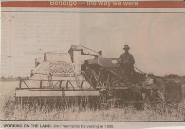
... JENNY FOLEY COLLECTION: WORKING ON THE LAND...Bendigo Advertiser ''The way we were'' from 2002. Working on the land: Jim Freemantle harvesting in 1930. The clip is in a folder....Newspaper JENNY FOLEY COLLECTION: WORKING ON THE LAND ...BHS CollectionBendigo Advertiser ''The way we were'' from 2002. Working on the land: Jim Freemantle harvesting in 1930. The clip is in a folder.newspaper, bendigo advertiser, the way we were -
 Bendigo Historical Society Inc.
Newspaper - JENNY FOLEY COLLECTION: THE MAN ON THE LAND
... JENNY FOLEY COLLECTION: THE MAN ON THE LAND...Bendigo Advertiser '' The way we were'' from Saturday, February 28, 2004. The man on the land: George McDonnell transports hay to Bendigo from Winzar farm, on five-tonne cart drawn by five horses. ...Newspaper JENNY FOLEY COLLECTION: THE MAN ON THE LAND ...BHS Collection Bendigo Advertiser '' The way we were'' from Saturday, February 28, 2004. The man on the land: George McDonnell transports hay to Bendigo from Winzar farm, on five-tonne cart drawn by five horses. The clip is in a folder.newspaper, bendigo advertiser, the way we were -
 Bendigo Historical Society Inc.
Newspaper - JENNY FOLEY COLLECTION: WORKING ON THE LAND
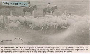
... JENNY FOLEY COLLECTION: WORKING ON THE LAND...Bendigo Advertiser "The way we were" from Friday, August 15, 2003. Working on the land: this photo of two farmers herding a flock of sheep on horseback was found by a Bendigo resident at the Mandurang tip. ...Newspaper JENNY FOLEY COLLECTION: WORKING ON THE LAND ...Bendigo Advertiser "The way we were" from Friday, August 15, 2003. Working on the land: this photo of two farmers herding a flock of sheep on horseback was found by a Bendigo resident at the Mandurang tip. It was only one of three unbroken glass negatives of old photographs.newspaper, bendigo advertiser, the way we were -
 Bendigo Historical Society Inc.
Newspaper - JENNY FOLEY COLLECTION: LIFE ON THE LAND
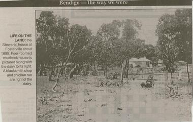
... JENNY FOLEY COLLECTION: LIFE ON THE LAND...Bendigo Advertiser ''The way we were'' from 2000. Life on the land: the Stewart's house at Fosterville about 1895. ...Newspaper JENNY FOLEY COLLECTION: LIFE ON THE LAND ...Bendigo Advertiser ''The way we were'' from 2000. Life on the land: the Stewart's house at Fosterville about 1895. Four-roomed mud brick house is pictured along with the dairy to its right. A blacksmith shop and chicken run are right of the dairy. The clip is in a folder.newspaper, bendigo advertiser, the way we were -
 Ballarat Tramway Museum
Document - Photocopies, State Electricity Commission of Victoria (SECV), "Electricity's the new power on the land", c1995
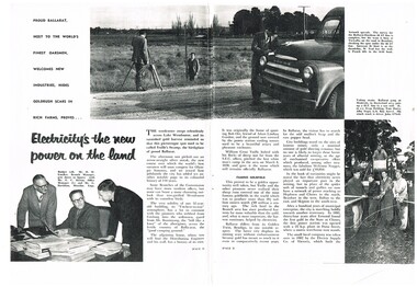
... "Electricity's the new power on the land"...Titled "Electricity's the new power on the land". Images added and record revised 30/10/2013...Titled "Electricity's the new power on the land". Images added and record revised 30/10/2013 "Electricity's the new power on the land" Document Photocopies State Electricity Commission of Victoria (SECV) ...Yields information about the SEC activities in the Ballarat district during the mid 1950's and has a strong association with a number of people in the article.Photocopy of ?/1956 pages 2- 7 of SEC News featuring SEC activities in the Ballarat area, trams, personnel, black and white photographs, 3 A3 size sheets. Titled "Electricity's the new power on the land". Images added and record revised 30/10/2013trams, tramways, secv, ballarat trams, personnel, power supply -
 National Wool Museum
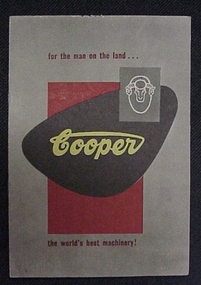
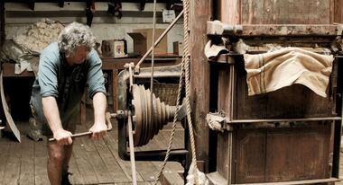
Booklet, For the man on the land... Cooper the world's best machinery!
... For the man on the land... Cooper the world's best machinery!...For the man on the land... Cooper the world's best machinery! ...Catalogue advertising shearing machinery by Cooper.Catalogue advertising shearing machinery by Cooper.shearing shearing machinery, cooper engineering company pty ltd sunbeam corporation limited, shearing, shearing machinery -
 Eltham District Historical Society Inc
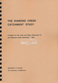
Book, Department of Zoology, The University of Melbourne, The Diamond Creek Catchment Study: A report on the Land and Water Resources of the Diamond Creek Catchment, 1994
... The Diamond Creek Catchment Study: A report on the Land and Water Resources of the Diamond Creek Catchment...Eltham District Historical Society Inc 728 Main Rd Eltham melbourne Shire of Nillumbik Spiral bound, soft cover, A4, 368 pages, 368 pages The Diamond Creek Catchment Study: A report on the Land and Water Resources of the Diamond Creek Catchment Book Book Department of Zoology, The University of Melbourne ...Shire of Nillumbik -
 Eltham District Historical Society Inc
Photograph postcard, On the land, Panton Hill, Vic; postcard dated 13 March 1907
... On the land, Panton Hill, Vic; postcard dated 13 March 1907...Eltham District Historical Society Inc 728 Main Rd Eltham melbourne michael aitken collection postcards Panton Hill Digital file only Postcards scanned from the collection of Michael Aitken on loan to EDHS, 13 Feb 2018 On the land, Panton Hill, Vic; postcard dated 13 March 1907 Photograph postcard ...Digital file only Postcards scanned from the collection of Michael Aitken on loan to EDHS, 13 Feb 2018michael aitken collection, postcards, panton hill -
 Round the Bend Conservation Co-operative
The Co-op was fortunate to have members with the professional skills to design, plan, cost, negotiate and organize this project effectively resulting in minimal impact on the land
... The Co-op was fortunate to have members with the professional skills to design, plan, cost, negotiate and organize this project effectively resulting in minimal impact on the land. ...Round the Bend Conservation Co-operative Bend Of Islands yarra-valley-and-the-dandenong-ranges The Co-op was fortunate to have members with the professional skills to design, plan, cost, negotiate and organize this project effectively resulting in minimal impact on the land. ... -
 Round the Bend Conservation Co-operative
Land management involves careful planning in all activities carried out on the land. Careful raking before burning can protect significant trees, bushes or orchids as well as providing a fire break
... Land management involves careful planning in all activities carried out on the land. ...Round the Bend Conservation Co-operative Bend Of Islands yarra-valley-and-the-dandenong-ranges Land management involves careful planning in all activities carried out on the land. ... -
 Ringwood and District Historical Society
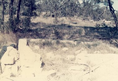
Photograph, Remains of the mud brick shed on the land owned by Robert Clarke, North Ringwood in Aug 1976
... Remains of the mud brick shed on the land owned by Robert Clarke, North Ringwood in Aug 1976...Remains of the mud brick shed on the land owned by Robert Clarke, North Ringwood in Aug 1976 Photograph ...Part of a 101-photo record of the development of the "Bel Air" Estate, Ringwood North, including road works to Debbie Place, Kubis Drive, Jenkins Close, Burlock Avenue, Pamela Court, Manuelo Terrace, Lyn Court, Rudolf Court, Werac Drive, Iluka Place and Glenvale Road. From the Jack Lundy Clarke collection (39 Burlock Avenue, North Ringwood) of photos taken from 1976 to 1982. The developer, Mr Kubis, named streets after his family and associates.Near the intersection of Manuela Terrace, Burlock Avenue and Lyn Court. Built in 1946 -
 Wonga Park Community Cottage History Group
Letter - Letter dated 18/10/1985 from the Shire of Lillydale to Margaret Fankhauser, agreeing to name the reserve on Upton land the Arthur John Upton Reserve
... agreeing to name the reserve on Upton land the Arthur John Upton Reserve...Letter dated 18/10/1985 from the Shire of Lillydale to Margaret Fankhauser agreeing to name the reserve on Upton land the Arthur John Upton Reserve...Wonga Park Community Cottage History Group Unit 1, 9 – 13 Old Yarra Road Wonga Park melbourne Letter dated 18/10/1985 from the Shire of Lillydale to Margaret Fankhauser agreeing to name the reserve on Upton land the Arthur John Upton Reserve agreeing to name the reserve on Upton land the Arthur John Upton Reserve Letter Letter dated 18/10/1985 from the Shire of Lillydale to Margaret Fankhauser ...Letter dated 18/10/1985 from the Shire of Lillydale to Margaret Fankhauser agreeing to name the reserve on Upton land the Arthur John Upton Reserve -
Tatura Irrigation & Wartime Camps Museum
Booklet, Making A Crust In The Depression and Entertaining Ourselves When Young, 1991
... ...life on the land...Stories of life on the land, early 1900's and how the young people entertained themselves,...Tatura Irrigation & Wartime Camps Museum 49 Hogan Street Tatura the-murray Stories of life on the land, early 1900's and how the young people entertained themselves, farming in the 1900's life on the land White booklet, black lettering, stories of early farming and fruit growing. ...Stories of life on the land, early 1900's and how the young people entertained themselves,White booklet, black lettering, stories of early farming and fruit growing. Kyabram and Lancaster area.farming in the 1900's, life on the land -
 National Wool Museum
Film - Ferrier Wool Press, Bonart Multimedia, 2015
... ...On The Land...Film commissioned for exhibition in On The Land at National Wool Museum, Geelong. Featuring Nicholas Cole at West Cloven Hills Station, speaking about the history of the Ferrier Wool Press. ...West Cloven Hills Station History Wool Press Ferrier Wool Press Nicholas Cole On The Land National Wool Museum Three minute seven second colour digital film with audio. ...Film commissioned for exhibition in On The Land at National Wool Museum, Geelong. Featuring Nicholas Cole at West Cloven Hills Station, speaking about the history of the Ferrier Wool Press. Three minute seven second colour digital film with audio.west cloven hills station, history, wool press, ferrier wool press, nicholas cole, on the land, national wool museum -
 Greensborough Historical Society
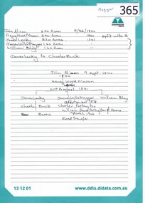
Genealogical Document, Family records: various sources, 15/02/1840o
... Families include: Mayger, Lecky, Britnell, Garthwaite, Green, Beale, Coulstock, Sherwin, Batey, Cobham, Partington, Catchpole, Whatmough.Contains transcript of land ownership in Greensborough area 1840-1906....One page of details transcribed from Land ownership 1840-1906....Land ownership notes are hand written....One page of details transcribed from Land ownership 1840-1906. Family records: various sources Genealogical Document ...Families include: Mayger, Lecky, Britnell, Garthwaite, Green, Beale, Coulstock, Sherwin, Batey, Cobham, Partington, Catchpole, Whatmough.Contains transcript of land ownership in Greensborough area 1840-1906.One page of details transcribed from Land ownership 1840-1906.Land ownership notes are hand written.greensborough -
 Phillip Island and District Historical Society Inc.
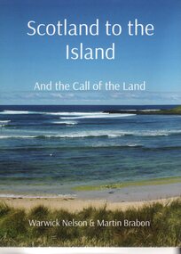
Book, Warwick Nelson & Martin Brabon, Scotland to the Island. And the call of the land, 2022
... And the call of the land....Robert Miller selected land in Ventnor in 1868. His daughter, Catherine, later lived nearby with the neighbouring bay named after her, Kitty Miller Bay....Book - Scotland to the Island and the call of the land. Large Book...Scotland to the Island. and the call of the land. Warwick Nelson & Martin Brabon...And the call of the land. Book Warwick Nelson & Martin Brabon ...The Miller family were one of the early settlers on Phillip Island. Robert Miller selected land in Ventnor in 1868. His daughter, Catherine, later lived nearby with the neighbouring bay named after her, Kitty Miller Bay.HistoricalBook - Scotland to the Island and the call of the land. Large BookScotland to the Island. and the call of the land. Warwick Nelson & Martin Brabonmiller family, kitty miller bay phillip island, catherine walker (nee kitty miller), warwick nelson, robert miller, farming, ventnor -
Clunes Museum
Document - LAND PURCHASE, 1862
... LAND PURCHASE...SPECIAL LAND PURCHASE CERTIFICATE FOR LAND PURCHASED BY JAMES GRIFFIS OF CLUNES, DATED 4TH APRIL 1862....CERTIFICATE OF SPECIAL LAND PURCHASE....ENTERED ON RECORD AND ENROLLED IN THE OFFICE OF THE REGISTRAR OF THE SUPREME COURT OF THE COLONY OF VICTORIA, IN REGISTER NO. 13 SPECIAL LAND PURCHASES, FOLIO 2483 THIS THIRTEENTH DAY OF MAY 1862. ...SIGNED BY ACTING REGISTRAR CERTIFICATE OF SPECIAL LAND PURCHASE. Document LAND PURCHASE ...SPECIAL LAND PURCHASE CERTIFICATE FOR LAND PURCHASED BY JAMES GRIFFIS OF CLUNES, DATED 4TH APRIL 1862.CERTIFICATE OF SPECIAL LAND PURCHASE.ENTERED ON RECORD AND ENROLLED IN THE OFFICE OF THE REGISTRAR OF THE SUPREME COURT OF THE COLONY OF VICTORIA, IN REGISTER NO. 13 SPECIAL LAND PURCHASES, FOLIO 2483 THIS THIRTEENTH DAY OF MAY 1862. SIGNED BY ACTING REGISTRARlocal history, document, certificates, griffis james -
 Orbost & District Historical Society
black and white photograph, late 19th century - early 20th century
... bendoc-land-clearing bendoc-early-settlement...This photograph shows land clearing at Bendoc. From 1845 the Bendoc area was part of pastoral leases. ...A badly distorted black / white photograph of a horse drawn wagon, three men and two women clearing land....on back - "Clearing land at Bendoc"...Some miners selected land, which in many cases is still held by descendants. ...This photograph shows land clearing at Bendoc. From 1845 the Bendoc area was part of pastoral leases. In the 1850s alluvial gold was discovered in the Bendoc River. This was quickly exhausted, and a number of mines began successful reef operations. At the head of the river, the settlement of Clarkville clustered round several other mines. Many miners, including numbers of Chinese, sluiced the rivers. The population of the area was as high as 500 during this period. The township was surveyed in 1869 and the hotel built in 1870. This building was burnt down in the early 1900s and rebuilt. A school was also begun at this time. In the 1870s there was a decline in gold mining. Some miners selected land, which in many cases is still held by descendants. Dairying was common in the early days, supplying a butter factory at the New South Wales border, and a milk factory at Orbost in more recent times. Wheat was grown for the settlers' own use and ground at Bombala. Now beef cattle grazing is the main occupation. (info. from Victorian Places)This is a pictorial history associated with the early settlement of Bendoc in East Gippsland.A badly distorted black / white photograph of a horse drawn wagon, three men and two women clearing land.on back - "Clearing land at Bendoc"bendoc-land-clearing bendoc-early-settlement -
 Greensborough Historical Society
Genealogical Document, Family records: various sources, 06/02/1854o
... Item 365 contains transcript of land ownership in Greensborough area 1840-1906....One page of details transcribed from various rolls and directories. Also Item 365 Land ownership 1840-1906....Land ownership notes are hand written....Also Item 365 Land ownership 1840-1906. Family records: various sources Genealogical Document ...Family details collected and transcribed from various sources: rolls, directories, insolvency lists, etc. Families include: Mayger, Lecky, Britnell, Garthwaite, Green, Beale, Coulstock, Sherwin, Batey, Cobham, Partington, Catchpole, Whatmough. Item 365 contains transcript of land ownership in Greensborough area 1840-1906.One page of details transcribed from various rolls and directories. Also Item 365 Land ownership 1840-1906.Land ownership notes are hand written.greensborough, mayger, lecky, britnell, garthwaite, green, beale, coulstock, sherwin, batey, cobham, partington, catchpole, whatmough. -
 Kiewa Valley Historical Society
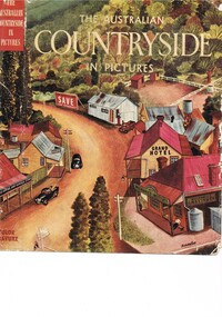
Book - Reference Countryside, The Australian Countryside in Pictures, circa 1950s
... ...life on the land...This unity within the rural environment is something that is attracting more and more families from sometimes alienating city life. country life australian "outback" rural industries life on the land swag-man of the bush On the tittle page is a signature "C Roper" This printed coloured sketched, or painted paper sleeve of the book is freely wrapped over a dark red hard cover. ...This book is a "snapshot" in time (1950s) detailing life in Australia covering a time when a "man's word and handshake" were his moral and quasi legal bond, and the now relative defunct saying "smoko" (having a "time out" from work for a cigarette and tea or coffee). The book spans an era where the male was still the "head" of the family even though for a majority of families the women took on the many "male only" roles during the World War II period. This shift in the leadership of the family hierarchy is mentioned, so ever slightly, (not to offend the still predominant macho male image) in both rural and city environments. The effects of the war, and later the push for women's emancipation and equality in both family, social, workplace and political areas of life, since this book was published, is now finally resolved. However there are still some sections of the recent migrate population where this male dominance is causing a few problems.The significance of this book is not only because it was donated by Mrs C. Roper ( from the Roper Family, a pioneer Kiewa Valley and surrounding Region family - originally beef cattle graziers) but also a Kiewa Valley resident and family, experiencing the shift in the social and economical life of post World War II rural Australia. The strong heritage link to this region of many families still residing within its boundaries, is a clear affirmation of the bond that the Kiewa Valley and its Regions have upon family unity. This unity within the rural environment is something that is attracting more and more families from sometimes alienating city life.This printed coloured sketched, or painted paper sleeve of the book is freely wrapped over a dark red hard cover. Into the front of the cover is pressed a standing pose of a farmer with long sleeves rolled up over his elbows. Behind him and to the right are what appears to be three sacks of wheat and next to him is a merino sheep. To the left and down are two dogs one with a fox in its jaws. The book contains 240 pages, 300 illustrations in gravure and 25 pictures in full colour. The inside fly leaf is a colour photograph of a rural scene with dirt road running in the centre and to the left a farm house and a five bay open storage barnOn the tittle page is a signature "C Roper"country life, australian "outback", rural industries, life on the land, swag-man of the bush -
 Clunes Museum
Photograph
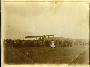
... ...first plane to land in clunes...PHOTO OF FIRST PLANE TO LAND IN CLUNES, NEAR THE OLD HOSPITAL....PHOTOGRAPH OF FIRST PLANE TO LAND IN CLUNES...HANDWRITTEN ON BACK - "ONE OF THE FIRST AEROPLANES TO LAND IN CLUNES (IF NOT THE FIRST). LANDED IN PADDOCK ALONGSIDE CLUNES HOSPITAL ON CRESWICK ROAD ABOUT 1920. ...Clunes Museum 36 Fraser Street enter building through Collins Place Clunes goldfields PHOTO OF FIRST PLANE TO LAND IN CLUNES, NEAR THE OLD HOSPITAL. local history photography photographs events and celebrations first plane to land in clunes HANDWRITTEN ON BACK - "ONE OF THE FIRST AEROPLANES TO LAND IN CLUNES (IF NOT THE FIRST). ...PHOTO OF FIRST PLANE TO LAND IN CLUNES, NEAR THE OLD HOSPITAL.PHOTOGRAPH / COPY OF AEROPLANE WITH CROWD OF PEOPLE. PHOTOGRAPH OF FIRST PLANE TO LAND IN CLUNESHANDWRITTEN ON BACK - "ONE OF THE FIRST AEROPLANES TO LAND IN CLUNES (IF NOT THE FIRST). LANDED IN PADDOCK ALONGSIDE CLUNES HOSPITAL ON CRESWICK ROAD ABOUT 1920. NOTE NURSE IN UNIFORM."local history, photography, photographs, events and celebrations, first plane to land in clunes -
Clunes Museum
Document - LAND PURCHASE AGREEMENT, 1862
... LAND PURCHASE AGREEMENT......land purchase...SALE OF CROWN LAND IN VICTORIA 1862...TO ABEL GRENFELL OF CRESWICK. LAND SITUATED IN ALLIANCE STREET, CLUNES....LAND SITUATED IN ALLIANCE STREET, CLUNES. SALE OF CROWN LAND IN VICTORIA 1862 Document LAND PURCHASE AGREEMENT ...SIGNED IN MELBOURNE 29TH MARCH 1862 BY SIR HENRY BARKLEY GOVERNOR-IN-CHIEF OF THE COLONY OF VICTORIASALE OF CROWN LAND IN VICTORIA 1862TO ABEL GRENFELL OF CRESWICK. LAND SITUATED IN ALLIANCE STREET, CLUNES.local history, document, land purchase, government, colonial government -
 Bacchus Marsh & District Historical Society
Map, Atkins and Clarke Land Sale situate at Bacchus Marsh 1856 Copy 2
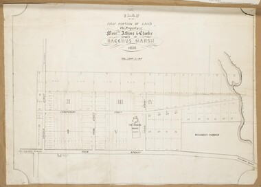
... Atkins and Clarke Land Sale situate at Bacchus Marsh 1856 Copy 2...Land Sales...This plan of land allotments for sale indicates the property once owned by the Bacchus family in and around the township area of Bacchus Marsh. ...A single page paper map showing a portions of land available for sale in Bacchus Marsh in 1856. ...Plan of the first portion of land. The property of Messers Atkins and Clarke situate at Bacchus Marsh....Atkins and Clarke Land Sale situate at Bacchus Marsh 1856 Copy 2 Map Shire of Bacchus Marsh ...This plan of land allotments for sale indicates the property once owned by the Bacchus family in and around the township area of Bacchus Marsh. The Bacchus family sold their property in Bacchus Marsh to John Atkins and Robert Nalder Clarke in March 1851. Atkins and Clarke kept the property for a number of years until April 1856 when these allotments were put up for sale.This plan is almost identical to another copy held by the Bacchus Marsh and District Historical Society, VC Record 707, BMDHS collection). This plan, VC Record 452 Copy 2, contains a less detail than than VC Record 707 Copy 1. For example the selling agents and the surveyor who created the plan are not indicated on this copy of the plan. This copy of the plan does indicate the name Crook Street on the map. As the Crook family were the buyers of the Manor House property and surrounding land from Atkins and Clarke in 1856 it suggests that this copy is a later one of the earlier version. It is unlikely that the Crook family would have had the adjacent street named after them prior to purchasing the house and property. This is a very early land sales plan for the township of Bacchus Marsh and it therefore provides some clues as to how the early urban development of the township took place. Upon seeing the map in 1911 Bacchus Marsh Express newspaper editor Christopher Crisp wrote "The sale appears to have created the present township, which had a nucleus in earlier times further east", Express, 30 September, 1911, page 3. A single page paper map showing a portions of land available for sale in Bacchus Marsh in 1856. The subdivided land shown was owned by John Atkins and Robert Nalder Clarke, but previously owned by the Bacchus Family and was in and around their Manor House (Mansion) property in Bacchus Marsh.There are 5 portions of land further divided into numerous small portions. The land for sale is bounded by the present day streets of Main Street, Young Street, McFarland Street, Morton Streets, Crook Street, and part of the eastern section extends to the Lerderderg River. Scale: 4 chains to 1 inch. The map is pasted into a bound volume containing 76 maps or plans in total. High resolution digital image stored on BMDHS computer network. Plan of the first portion of land. The property of Messers Atkins and Clarke situate at Bacchus Marsh.land sales, land sales bacchus marsh, manor house bacchus marsh, crook family bacchus marsh -
 Bendigo Historical Society Inc.
Administrative record - The Land Act 1869
... The Land Act 1869...Land act...The Victorian Parliament passed Land Acts in 1860, 1862 and 1869, which offered settlers land within defined agricultural areas. ...The book contains amendments to the land act 1869. throughout the book there are handwritten notes with names and localities...Red pen mark at the front Land(?) 869. some of the nameswriten are: Sanderson, O'Brien, H. ...(from Wikipedia) Land act Victorian legislation Red pen mark at the front Land(?) ...The Victorian Parliament passed Land Acts in 1860, 1862 and 1869, which offered settlers land within defined agricultural areas. Settlers paid for half of an allotment on selection at a uniform price of £1 per acre and paid rent on the other half for usually 7 years. By the end of the period, to obtain title to the land, settlers would have had to pay the balance of the purchase price and make certain improvements. (from Wikipedia)Blue book missing front cover, some loose pages. The book contains amendments to the land act 1869. throughout the book there are handwritten notes with names and localitiesRed pen mark at the front Land(?) 869. some of the nameswriten are: Sanderson, O'Brien, H. Jackson, R. Wharton, W. Porter, J. Stewart, Foley and Mortonland act, victorian legislation -
 Bendigo Historical Society Inc.
Document - LAND SALES REGISTER - 1882 - 1909, 1882 - 1909
... LAND SALES REGISTER - 1882 - 1909...land sales...Journal: Hard cover journal, dark green cover with buff corners and spine. Land Sales by auction 1882 - 1909. The sale of land in the following areas: Sandhurst, Bendigo, Heathcote, Shepparton, Inglewood, Rushworth. ...Land Sales Office...Land Sales by auction 1882 - 1909. The sale of land in the following areas: Sandhurst, Bendigo, Heathcote, Shepparton, Inglewood, Rushworth. ...Journal: Hard cover journal, dark green cover with buff corners and spine. Land Sales by auction 1882 - 1909. The sale of land in the following areas: Sandhurst, Bendigo, Heathcote, Shepparton, Inglewood, Rushworth. On front cover label (light buff) in blue ink, Bendigo, Sale Register, 1882 - 1909. On spine red label with gold lettering: Report of sales by auction.Land Sales Officeland sales, bendigo, sandhurst, auctions, sales register -
 Bendigo Historical Society Inc.
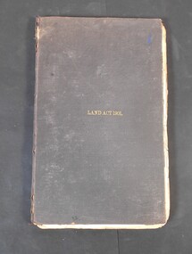
Legal record - Land Act 1901
... Land Act 1901...Land Act 1901...Black hardcover book. Land Act 1901 in gold letters on the font. ...Land Act 1901 on the cover...History House 11 Mackenzie Street Bendigo goldfields Land Act 1901 legal record Land Act 1901 on the cover Black hardcover book. ...Black hardcover book. Land Act 1901 in gold letters on the font. The book has 286 pages with few handwritten notes attached to the pages.Land Act 1901 on the coverland act 1901, legal record -
Whitehorse Historical Society Inc.
Document, Robert Collier Land, 1903
... Robert Collier Land...Morton & Coghill 10 Aug 1903; statement and receipt from Maddock & Jamison for services relating to above sale and to purchase of land in Tunstall from Freehold Investment Company 6 Nov 1903....Papers relating to land dealings by Robert Collier of Springvale Road Tunstall. ...Morton & Coghill 10 Aug 1903; statement and receipt from Maddock & Jamison for services relating to above sale and to purchase of land in Tunstall from Freehold Investment Company 6 Nov 1903....Robert Collier Land Document Document ...50 acres and house in Canterbury Road Blackburn to I.N. Cuttle for (pounds)590Papers relating to land dealings by Robert Collier of Springvale Road Tunstall. 50 acres and house in Canterbury Road Blackburn to I.N. Cuttle for (pounds)590collier, robert, t.r.b morton & coghill, maddock & jamison, canterbury road blackburn, freehold investment company of australia ltd -
Whitehorse Historical Society Inc.
Article, Rating on unimproved land values, 1911
... Rating on unimproved land values....Complaining about the difference between rating of unimproved land and improved land....Complaining about the difference between rating of unimproved land and improved land....Rating on unimproved land values. Article Article ...A letter from 'Ratepayer' in the Open Column of the Reporter (Box Hill).A letter from 'Ratepayer' in the Open Column of the Reporter (Box Hill) .A letter from 'Ratepayer' in the Open Column of the Reporter (Box Hill). shire of nunawading, mitcham road mitcham, whitehorse road mitcham, station street mitcham -
4th/19th Prince of Wales's Light Horse Regiment Unit History Room
Book, Joseph Wones Ltd, Land Rover Series IIA Owner's Manual, Oct 1962
... Land Rover Series IIA Owner's Manual......Land Rover...Soft covered owner's manual for the Land Rover Series II A....Land Rover Series IIA Part No 4482 'Regular', 'Long' and Forward Control Owner's Manual ...Land Rover Series IIA Owner's Manual Book Joseph Wones Ltd ...Manual for vehicles used by the RegimentSoft covered owner's manual for the Land Rover Series II A.Land Rover Series IIA Part No 4482 'Regular', 'Long' and Forward Control Owner's Manual user manual, land rover -
 Kew Historical Society Inc
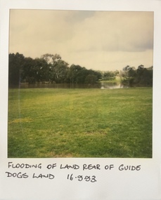
Photograph - Flooding at parkland at rear of Guide Dogs Victoria, 1993
... This includes the land, designated as parkland which adjoins the Yarra River. ..."Flooding of land rear of Guide Dogs land 16.9.93"...This includes the land, designated as parkland which adjoins the Yarra River. ...The land currently occupied by Guide Dogs Victoria was once part of the grounds of the Kew Lunatic Asylum. This includes the land, designated as parkland which adjoins the Yarra River. It is now designated as the Chandler Park.Original colour small format polaroid photograph of flooding in parkland at the rear of Guide Dogs Victoria in the area now used as the Main Yarra Trail; taken on 16 September 1993."Flooding of land rear of Guide Dogs land 16.9.93"yarra river -- floods -- kew (vic.), guide dogs victoria, main yarra trail, chandler park