Showing 78 items matching "on-site dwelling"
-
 The Beechworth Burke Museum
Photograph
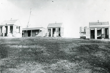
... ...on-site dwelling...Further research into the importance of the Hospital in Beechworth and it's connection to the town will be supported through images like these kept in the Mayday Hills photo album in the collection of the Burke Museum. mental hospital mayday hills beechworth copy nurse nurses quarters on-site dwelling 1900s 1880 beechworth asylum Black and white rectangular photograph printed on gloss photographic paper Photograph Photograph ...These images are copies of a photograph (3448) captured in approximately 1900 and depicts the on site nurses homes. During the 1880s, these detached cottages were constructed and provided accommodation for the staff (in this case, the nurses) who lived within the hospital walls. Within the image are weatherboard buildings, a number of nurses and water tanks. Beechworth's Mayday Hills was chosen as the site of Victoria's newest asylum, at the time, due to the landscape and altitude. The hilltop atmosphere and the native fauna, it was argued, would assist in the cure of the patients kept at the hospital (Wood 1985, 122). The positioning of the hospital had a beneficial effect on the rural town. A pamphlet published by James Ingram and Son (1849) reveal that famous landmarks in Beechworth which included the Post Office, Gaol, Courthouse and Asylum "demonstrate the appreciation of Beechworth by the Government not only as as important district center, but also as a site unrivaled as a sanitarium". There were other locations in contention at the time, but ultimately Beechworth was chosen (Craig 2000, 33). Prior to the creation of the Asylum in Beechworth, those charged with having mental illnesses or, as it was termed, "insanity" were unable to be properly cared for in the Gaol (which is where they were often sent). John Buckley Castieau wrote, in 1861 for the Ovens and Murray Advertiser, that the Gaol was unable to properly care for those classified then as "insane" but that they would endeavor to treat them above the other inmates (which he notes is not always the case in other establishments). Castieau wrote this in favour of supporting the building of the Mayday Hills Hospital in Beechworth. It was stated that at the time the Mayday Hills Hospital was built, there were 83 prisoners kept in the Gaol who were to be rehoused to the Hospital on the grounds of "insanity". The classification as someone as "insane", in this period of time is a reflection on the inability to cure and understand illnesses of the mind during the mid to late 1800s. Opening on the 24th of October 1867, the Mayday Hills Hospital was originally named the "Ovens Lunatic Asylum", a title which is very much a product of its time. Whilst controversial, changes to the name is part of the history of the Hospital and can provide much insight into the understanding of mental illness throughout history and the use/disuse of this term provides information into the reception/changing opinions of mental illness in society. The Hospital would later become known as the "Mayday Hills Asylum" and/or "Mayday Hills Hospital" with the latter being the most commonly used title. An article in the Ovens and Murray Advertiser notes that on the 7th of March 1865, the foundation stone of the Hospital was laid (it would officially open in 1867) and that it was such a moment of accomplishment and joy for Beechworth that a letter to the editor even suggested that there should be a holiday dedicated to the day the foundation stone as laid. This reveals an extent to which the townspeople of early Beechworth valued the construction of the Hospital in their town. It provided the town with a sense of prestige and honour.At first glance, the remains of the Mayday Hills Hospital in Beechworth, Victoria, inspire tragedy, trauma and beauty. The buildings themselves, with their Italianate style Renaissance architecture designed by J.J. Clark (Craig 2000, 49 & Smith 2016, 203) reflect a bygone period of European and Australian history. The gardens provide a sense of tranquility and beauty. The experience of those within these walls remains a valuable area of study to provide a more complete understanding. This particular hospital is considered the fourth of its like and one of three identified as the largest of their kind. The Mayday Hills Hospital is a sister to the Kew and Ararat Asylums in Melbourne which are both located in relative proximity. Understanding the role of the Mayday Hills Hospital in Beechworth history is integral to understanding the development of the goldfields town, but also for providing important information as to the history of caring for, and the reception of, mental illnesses in Australian and wider European history. Mayday Hills provides a case study which can be researched through oral history, an analysis of the grounds/buildings and through images like these. Images like these depict the strong façade of the Hospital and provide a glimpse into the tranquility of the gardens. This has been done deliberately to provide a sense of comfort and healing about the building to those looking from the outside. Further research into the importance of the Hospital in Beechworth and it's connection to the town will be supported through images like these kept in the Mayday Hills photo album in the collection of the Burke Museum.Black and white rectangular photograph printed on gloss photographic papermental hospital, mayday hills, beechworth, copy, nurse, nurses quarters, on-site dwelling, 1900s, 1880, beechworth asylum -
 Bendigo Historical Society Inc.
Photograph - GOLD MINES BENDIGO 1861, 1861
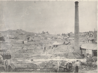
... Copy of photograph of mine site with dwellings to right top, mine buildings, 'whim?' ...see also 131.01 Copy of photograph of mine site with dwellings to right top, mine buildings, 'whim?' ...Copy of photograph of mine site with dwellings to right top, mine buildings, 'whim?' drays, horse and work men. Large brick chimney on right. B+W photo. On back 'Gold Mines Bendigo 1861','Probably, looking NW up New Chum Hill, which was then known as Sth Victoria Hill'.place, mining site, sth victoria hill ?, see also 131.01 -
 Bendigo Historical Society Inc.
Document - H.A. & S.R. WILKINSON COLLECTION: CONTRACT OF SALE
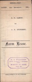
... Stevenson (lessee) for parcel of land situate in Keck Street, Bendigo approx 2 acres, including dam site with dwellings out-houses and all improvements to have and to hold for a term of 1 year and 4 weeks upon the following conditions: One- the term of tenancy shall be from the ninth of December 1933 to the fifth of January, 1935. ...Stevenson (lessee) for parcel of land situate in Keck Street, Bendigo approx 2 acres, including dam site with dwellings out-houses and all improvements to have and to hold for a term of 1 year and 4 weeks upon the following conditions: One- the term of tenancy shall be from the ninth of December 1933 to the fifth of January, 1935. ...This business was owned by father and son, Henry Archibald Wilkinson and Samuel Ronald "Ron" Wilkinson. Henry (1882-1954) was born in Shepparton and died in Bendigo. He was married to Grace Hovendon in 1908. Samuel Ronald "Ron" (1914-1995), Henry's son, was married to Florence Jean McKerlie in 1937.Farm lease dated 9th December, 1933 between W.T. Dawson (lessor) and P.R. Stevenson (lessee) for parcel of land situate in Keck Street, Bendigo approx 2 acres, including dam site with dwellings out-houses and all improvements to have and to hold for a term of 1 year and 4 weeks upon the following conditions: One- the term of tenancy shall be from the ninth of December 1933 to the fifth of January, 1935. Two- that rent for the said term shall be at the clear annual rental of 58 pounds and 10 shillings payable quarterly in advance.organization, business, h.a. & s.r wilkinson real estate -
 Mt Dandenong & District Historical Society Inc.
Photograph, Home and Shop of Edward Joseph Price
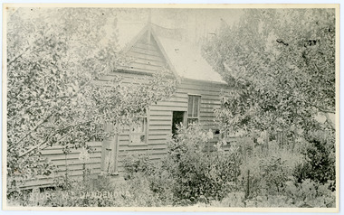
... On Front STORE MT DANDENONG On Reverse Home and Shop of Edward Joseph Price LOT 1 SECT 1 erected in 1908 on site of earlier dwelling from which goods had been sold without a special room for shop. ...The house faced Ridge Road. edward joseph price store shop On Front STORE MT DANDENONG On Reverse Home and Shop of Edward Joseph Price LOT 1 SECT 1 erected in 1908 on site of earlier dwelling from which goods had been sold without a special room for shop. ...John Lundy-Clarke grew up in the Kalorama/Mt Dandenong area and later in life (1972-74) began to write a comprehensive history of the district working from an original settlement map in an effort to cover all areas. Edward Joseph Price was the first settler to take up a lot (Lot 1, Section 1) in the Village Settlement. He built a slab hut and brought up his family in 1896. This photograph shows a newer home built in 1908. It had a section used as a shop and also had a large room built that was to be used for public gatherings. Health department regulations led to this being impossible. The house faced Ridge Road.Black and white close up photograph showing a building made from wooden boards with trees in the front. Reverse of photograph has handwritten description by John Lundy-Clarke.On Front STORE MT DANDENONG On Reverse Home and Shop of Edward Joseph Price LOT 1 SECT 1 erected in 1908 on site of earlier dwelling from which goods had been sold without a special room for shop. In picture the room on the extreme left was bedroom for boys Charlie and Ted (Edward John). Under the gable was a large room planned for public use but never used owing to Health Department Regulations. The narrow door (open) and window were the shop which was the district’s first newsagency. Window behind leaves at right was the kitchen. 1908-1912. Gabled portion is now part of home “Mirra Laken” 1975edward joseph price, store, shop -
 Whitehorse Historical Society Inc.
Photograph - Colour Photograph, Britannia Street, Mitcham, 13/06/1986 12:00:00 AM
... Shops on Western side of Britannia Street are located on the site of Barelli's shop, dwelling and bakehouse. To the north of these buildings and across a cobblestone lane now called Enterprise Way was the Salvation Army Citadel, .a further commercial building housing a printer. ...Shops on Western side of Britannia Street are located on the site of Barelli's shop, dwelling and bakehouse. To the north of these buildings and across a cobblestone lane now called Enterprise Way was the Salvation Army Citadel, .a further commercial building housing a printer. ...2 Coloured photos of Brittania Street, Mitcham. Looking North from Corner of Whitehorse Road. Shops on Western side of Britannia Street are located on the site of Barelli's shop, dwelling and bakehouse. To the north of these buildings and across a cobblestone lane now called Enterprise Way was the Salvation Army Citadel, .a further commercial building housing a printer. Erection of this building necessitated demolition of Barelli's stable and reclamation of its horse yard. The Salvation Army are now located on the Mitcham Road and Harrison Street corner.britannia street mitcham, shops -
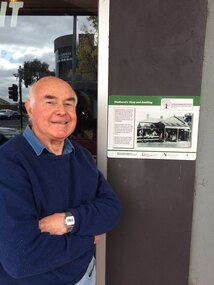
 Eltham District Historical Society Inc
Document - Property Binder, 16 Homestead Road, Eltham, 'Handfield House'
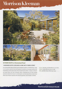
... The courtyard planning, floor to ceiling glass walls and the combination of single and double storey sections on the steep site illustrate quite advanced dwelling design for its time. ...The courtyard planning, floor to ceiling glass walls and the combination of single and double storey sections on the steep site illustrate quite advanced dwelling design for its time. ...Contents: 1. Morrison Kleeman Sales brochure 2008 2. Newsclipping; Advertisement, Morrison Kleeman, Eltham South 16 Homestead Road, Diamond Valley Leader, November 5, 2008, p7 (on reverse, p8 Advertisement, Morrison Kleeman, Eltham 45 Lavender Park Road) Designed by Robin Boyd for friends John and Esta Handfield, Handfield House was built 1961. In a letter dated 16 May 1989 to Blanche Shallard of the Shire of Eltham Historical Society, John Handfield advised that the house was designed by their friend Robin Boyd and that it was built in 1961. As of that date they had been the only occupants. They were still the owners when the house was included in the 1992 Shire of Eltham Heritage Study The 1992 Study advised: CULTURAL SIGNIFICANCE Designed by well-known Victorian Architect Robin Boyd after he returned from lecturing architectural students in Japan, the Handfield residence shows the influence of traditional Japanese design in its modular wall arrangements, solid and glazed panels and sliding exterior doors. The courtyard planning, floor to ceiling glass walls and the combination of single and double storey sections on the steep site illustrate quite advanced dwelling design for its time. Designed to house three generations, grandparents, their children and grandchildren, the house at the time of the 1992 study was reported to be very intact. DESCRIPTION Quite advanced design, in planning and detailing. Plan U-shaped. Single and double storied; the arms of the U are basically single storied, while the base running parallel with the Yarra River is two storied. Walls timber stud framed?, asbestos cement sheet clad. Roofs flat?. Floors timber, some concrete?. Features include the modular wall design, courtyard planning, combination of single and double storey sections, internal planning and floor to ceiling glass walls. SOURCES OF INFORMATION: Information from Mr. John Handfield. CONSERVATION GUIDELINES: Keep this residence intact. Esta Handfield died in 1995 The property was sold in 1996 Property history (source realestate.com.au) 2022 – Sold $2,240,000 September 17, 2022 by Jellis Craig - Eltham 1998 – Sold $348,500 June 20, 1998 1996 – Sold $250,000 September 9, 1996 (possibly Stockdale & Leggo) The property was offered for sale in 2008 by Morrison Kleeman with a price guide of $900,00 to $990,00 but it has not been confirmed if this sale proceeded property, eltham, houses, john handfield, esta handfield, robin boyd, 16 homestead road, handfield house, 45 lavender park road -
 Warrnambool and District Historical Society Inc.
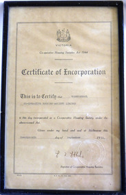
Certificate - Warrnambool Co-operative Housing Society Limited Certificate of Incorporation, 1951
... site, plans and amount that they would like to spend. The co-operatives were administered by accounting firms. There were conditions placed on the borrowers in regard to amounts able to be borrowed and size of dwelling and percentage of cost which could be borrowed....site, plans and amount that they would like to spend. The co-operatives were administered by accounting firms. There were conditions placed on the borrowers in regard to amounts able to be borrowed and size of dwelling and percentage of cost which could be borrowed. ...Co-operative housing societies were loan societies established in the mid to late 20th century. They were based on the structure of a group of borrowers approximately 40, who lived within a radius of thirty miles joining a co-operative. They had the right to select their own site, plans and amount that they would like to spend. The co-operatives were administered by accounting firms. There were conditions placed on the borrowers in regard to amounts able to be borrowed and size of dwelling and percentage of cost which could be borrowed.The era of post-World War Two saw a shortage in a number of areas one of which was housing. The co-operative Housing scheme was preferred by many as it avoided the block approach which had been used by the Housing commission. The co-operative housing scheme proved to be of benefit to many families around that time.Framed certificate with black text Stylised frame around text. Paper is cream.H.E Daw Gov Print., Melb. Victorian Government seal in bottom Right hand corner. Registrar of Co-operative housing societies, Victoria. warrnambool, co-operative housing society 1951 -
 Victoria Police Museum
Police Stations (Apollo Bay)
... site of the current Mechanics' Institute and changed its name to the Apollo Bay Police Station on 1 September 1990. It came under the Barwon District in 1948 and "Lima" Western District from 4 March 1990. In 1930 the police station was located to 29 Nelson Street. It was a seven-roomed weather-board dwelling...site of the current Mechanics' Institute and changed its name to the Apollo Bay Police Station on 1 September 1990. It came under the Barwon District in 1948 and "Lima" Western District from 4 March 1990. In 1930 the police station was located to 29 Nelson Street. It was a seven-roomed weather-board dwelling ...Apollo Bay is a coastal town in southwestern Victoria. It is situated on the eastern side of Cape Otway, along the edge of the Barham River and on the Great Ocean Road, in the Colac Otway Shire. The original township was surveyed in 1853 and named Middleton. In 1881 the town was renamed Krambruk which was changed to Apollo Bay in 1898. The Krambruk Police Station was opened on 7 March 1888 in the Southern District on land opposite the site of the current Mechanics' Institute and changed its name to the Apollo Bay Police Station on 1 September 1990. It came under the Barwon District in 1948 and "Lima" Western District from 4 March 1990. In 1930 the police station was located to 29 Nelson Street. It was a seven-roomed weather-board dwelling on three-quarters of an acre of land. It consisted of six rooms of pine, lined and painted; one pantry; one bathroom and wash-house; one hall; one office and one W.C.. There was stabling for one horse and one cell for prisoners. It was staffed by one Mounted Constable. In the early 1970s land was acquired at 31 Nelson Street and a new police station was constructed. This was a three-roomed brick building with a cell block at the rear. By the time it closed in 2005 it had been extended twice. On 17 November 2006 the current Apollo Bay Police Station opened in its current location at 35a Nelson Street, on the corner of Cartwight Street). Outside the peak summer season, the station is open 16 hours per day and staffed by one sergeant and five other members. 3 black & white photos and 2 coloured photospolice stations; apollo bay police station -
 Orbost & District Historical Society
newspaper clippings, April, May 1987
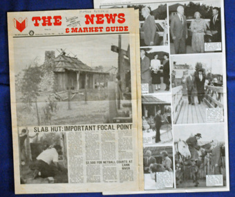
... The hut was an original family dwelling built in 1872, on a site approximately three kilometres upstream from the junction of the Buchan and Snowy Rivers. ...The hut was an original family dwelling built in 1872, on a site approximately three kilometres upstream from the junction of the Buchan and Snowy Rivers. ...The Slab Hut (Orbost Visitor Information Centre) was opened on March 28, 1987. It was officially opened by Dr D. Caughey, the governor of Victoria. The Orbost Visitor Information Centre is situated in Forest Park on Nicholson Street. The centre is housed in the historic Slab Hut. The hut was an original family dwelling built in 1872, on a site approximately three kilometres upstream from the junction of the Buchan and Snowy Rivers. The Hut was removed from its original site around 1970, and stored until 1984 when the Shire Council approved the current site. It was restored and brought to life as a Tourist Information Centre in 1987.The Slab Hut is an icon of Orbost. These newspaper articles are contemporary records of the opening of this building.A selection of articles from The News and the Snowy River Mail. All relate to the opening of the Slab Hut, the Orbost Visitor Information Centre. They are photographs, information and the history of the Slab Hut.slab-hut-orbost newspaper-snowy-river-mail -
 Orbost & District Historical Society
framed photograph, 14.4.2004
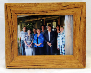
... The hut was an original family dwelling built in 1872, on a site approximately three kilometres upstream from the junction of the Buchan and Snowy Rivers. ...This photograph was taken on 14.4.2004 at the time of the visit to Orbost by the Governor of Victoria, John Landy.The Orbost Visitor Information Centre is situated in Forest Park on Nicholson Street. The centre is housed in the historic Slab Hut. The hut was an original family dwelling built in 1872, on a site approximately three kilometres upstream from the junction of the Buchan and Snowy Rivers. The Slab Hut is an Orbost Icon. It supports one part time manager and a team of dedicated volunteers.A coloured photograph in a wooden frame. A group of people stand in front of the Slab Hut (Orbost Information Centre) .On frame - NATURAL FEATURED HARDWOOD MADE BY 20.12.98 W. ASHLYN MARLO VIC.slab-hut-committee photograph -
 Orbost & District Historical Society
album, Orbost Visitor Information Centre, 1997
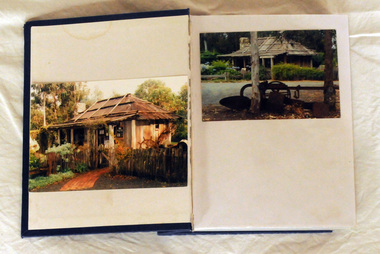
... The original slab hut was built in 1872 as a family dwelling on a site about 3 km upstream from the junction of the Buchan and Snowy Rivers about 40 kms from Orbost on the Yalmy Rd. ...Orbost & District Historical Society Ruskin Street Orbost gippsland The original slab hut was built in 1872 as a family dwelling on a site about 3 km upstream from the junction of the Buchan and Snowy Rivers about 40 kms from Orbost on the Yalmy Rd. ...The original slab hut was built in 1872 as a family dwelling on a site about 3 km upstream from the junction of the Buchan and Snowy Rivers about 40 kms from Orbost on the Yalmy Rd. No nails were used in the construction; it was all wired together. After a period in storage the Slab Ht was opened in its present location in Orbost as the Information Centre in 1987. This album documents an important event in Orbost.A photo album with a navy blue cardboard cover with gold embossing on the front and spine. It contains 32 photos of the 1997 10 year anniversary celebration of the establishment of the Slab Hut - the Orbost Visitor Information Centre. It also contains 3 postcards and 2 fridge magnets.slab-hut album orbost -
 Orbost & District Historical Society
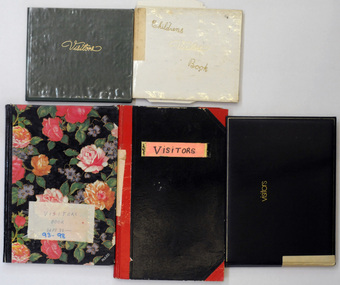
visitor books, 1987 -1989
... This slab hut was built in 1872 as a family dwelling on a site about 3 km upstream from the junction of the Buchan and Snowy Rivers about 40 kms from Orbost on the Yalmy Rd. ...These books were used at the Slab Hut (Orbost Visitor Information Centre) as visitor sign in books. Orbost. This slab hut was built in 1872 as a family dwelling on a site about 3 km upstream from the junction of the Buchan and Snowy Rivers about 40 kms from Orbost on the Yalmy Rd. No nails were used in the construction; it was all wired together. After a period in storage the slab hut was opened in its present location in Orbost as the Information Centre in 1987. The Slab Hut is an Orbost icon.Five books used by the Slab Hut (Orbost Visitor Information Centre) as visitor sign in books. 2467.1 has a green cover with "Visitors" in gold print and is dated 28.3.87 - 6.7.87. 2467.2 has a black cover with a gold border and "Visitors" in gold print. It is dated 11.6.87 - 3.11.89. 2467.3 has a black cover with red corners and spine. 2467.4 has pink and red flowers on a black background and is dated Sept 93 - 9.3.98. 2467.5 is a Children's Visitor Book and has a white cover with gold print. It is dated 9.4.87 -23.7.89. All contain handwritten comments, details of visitors to the Orbost Visitor Information Centre.2467.1 - Inside front cover - OFFICIALLY OPENED 28.3.1987 by VIC. GOVERNOR DAVIS McCAUGHEY 2467.2 - label on spine - VISITOR BOOK 2 inside a circle. 2467.3 - label on front - VISITORS ; label on spine - dates Feb 89 - Sep 93 2467.4 - label on front - VISITOR'S BOOK Sept 93 -9.3.98 tourissm slab-hut orbost-visitor-information-centre -
 Orbost & District Historical Society
documents in folder, 1988 -1992
... This slab hut was built in 1872 as a family dwelling on a site about 3 km upstream from the junction of the Buchan and Snowy Rivers about 40 kms from Orbost on the Yalmy Rd. ...These folders contain letters written to the Slab Hut either requesting information or making comments. There are copies of the replies.The Slab Hut (Orbost Visitor Information Centre) is an Orbost icon. This slab hut was built in 1872 as a family dwelling on a site about 3 km upstream from the junction of the Buchan and Snowy Rivers about 40 kms from Orbost on the Yalmy Rd. No nails were used in the construction; it was all wired together. After a period in storage the slab hut was opened in its present location in Orbost as the Information Centre in 1987.Two manila folders containing correspondence to/from Orbost Visitor Information Centre. The letters are tied together with string/ribbon. Most are information requests with copies of the replies.correspondence-orbost-visitor-information-centre tourism -
 Orbost & District Historical Society
albums, late 1980's
... The hut was an original family dwelling built in 1872, on a site approximately three kilometres upstream from the junction of the Buchan and Snowy Rivers. ...The hut was an original family dwelling built in 1872, on a site approximately three kilometres upstream from the junction of the Buchan and Snowy Rivers. ...These two albums were used at the Slab Hut - Orbost Visitor Information Centre. The Orbost Visitor Information Centre is situated in Forest Park on Nicholson Street. The centre is housed in the historic Slab Hut. The hut was an original family dwelling built in 1872, on a site approximately three kilometres upstream from the junction of the Buchan and Snowy Rivers. No nails were used in the construction; it was all wired together. After a period in storage the slab hut was opened in its present location in Orbost as the Information Centre in 1987.These albums are contemporary records of the construction and relocation of an iconic Orbost building, the Slab Hut.Two large photo albums. 2280.1 has no front cover. The back cover and spine are red. The pages are black and most photos are labelled. They are photographs of the Orbost area. 2280.2 has brown covers. It contains photographs of the construction of the gardens and buildings around the Slab Hut (Orbost Visitor Information Centre). On the cover in gold print is "PHOTOS".slab-hut-orbost album-photographs-orbost -
 Orbost & District Historical Society
album, 1990's?
... This slab hut was built in 1872 as a family dwelling on a site about 3 km upstream from the junction of the Buchan and Snowy Rivers about 40 kms from Orbost on the Yalmy Rd. ...This slab hut was built in 1872 as a family dwelling on a site about 3 km upstream from the junction of the Buchan and Snowy Rivers about 40 kms from Orbost on the Yalmy Rd. ...This album was used at the Orbost Visitor Information Centre (the Slab Hut). The Slab Hut (Orbost Visitor Information Centre) is an Orbost icon. This slab hut was built in 1872 as a family dwelling on a site about 3 km upstream from the junction of the Buchan and Snowy Rivers about 40 kms from Orbost on the Yalmy Rd. No nails were used in the construction; it was all wired together. After a period in storage the slab hut was opened in its present location in Orbost as the Information Centre in 1987.This item is a useful reference tool for the history of Orbost.A large photo album containing copies of photographs, some historical articles and b/w photos of Orbost. The covers are brown with a narrow gold frame. it has no spine and the covers are tied with tape. The pages, all different sizes, are bolted in.orbost-history album-photographs -
 Eltham District Historical Society Inc
Photograph - Digital Photograph, Alan King, Panton Hill Primary School, 27 March 2008
... site. Though now unrecognisable, the school building includes the classroom of the last Smiths Gully State School No 1737, which was built in 1882, and moved to Panton Hill in 1894. From 1922 each school day began with the ringing of the bell, which is still in its stand, and is an unusually old memorial of this kind. To accommodate the growing population, the building was remodelled, with additions in 1923 and classrooms were added in 1955, 1963 and 1970. The former teacher’s residence is the only surviving 19th century dwelling...site. Though now unrecognisable, the school building includes the classroom of the last Smiths Gully State School No 1737, which was built in 1882, and moved to Panton Hill in 1894. From 1922 each school day began with the ringing of the bell, which is still in its stand, and is an unusually old memorial of this kind. To accommodate the growing population, the building was remodelled, with additions in 1923 and classrooms were added in 1955, 1963 and 1970. The former teacher’s residence is the only surviving 19th century dwelling ...The Panton Hill Primary School building, which has served the community since 1889, was not the area's first. Kingston School (an early name for Panton Hill) opened in May 1865. This was replaced in 1871 when the Panton Hill School number 1134 opened and in 1874 the school moved to its current location [September 2023] where many additions and renovations have taken place to meet the needs of local children in the 21st century. Covered under Heritage Overlay, Nillumbik Planning Scheme. Published: Nillumbik Now and Then / Marguerite Marshall 2008; photographs Alan King with Marguerite Marshall.; p63 The Panton Hill Primary School building, which has served the community since 1889, was not the area’s first. In 1871 Henry Edelman opened a Common School in a paling-clad hut, replacing the Kingstown No 786 school. The two-acre (0.8ha) site of crown land had previously been held under Miners Right. In 1875 the Education Department bought a building on the main road for State School No 1134, for £200 and remodelled it as a school.4 Panton Hill had as one of its teachers, Frank Tate, who was to become one of Victoria’s most influential educational reformers. It was his first school, when he began teaching on January 22, 1884, as a 20 year old.5 The following month Robert J Harris was appointed to the school and remained as head teacher until his death in 1887. His son R C Harris was apprenticed to Mr Rossiter, editor of the first local paper. The Evelyn Observer, first published in 1873. Harris later bought the newspaper which remained a family business until the 1920s. J Hughes of Cherry Tree Road succeeded Harris as teacher at Panton Hill and sold his land for the school site. Though now unrecognisable, the school building includes the classroom of the last Smiths Gully State School No 1737, which was built in 1882, and moved to Panton Hill in 1894. From 1922 each school day began with the ringing of the bell, which is still in its stand, and is an unusually old memorial of this kind. To accommodate the growing population, the building was remodelled, with additions in 1923 and classrooms were added in 1955, 1963 and 1970. The former teacher’s residence is the only surviving 19th century dwelling in the centre of Panton Hill, and is now used as part of the school. The residence was originally rectangular but is now L-shaped. Similar weatherboard State School buildings in the shire from this period are the Kangaroo Ground and the St Andrews Primary Schools. All were standard Education Department/Public Works Department designs.This collection of almost 130 photos about places and people within the Shire of Nillumbik, an urban and rural municipality in Melbourne's north, contributes to an understanding of the history of the Shire. Published in 2008 immediately prior to the Black Saturday bushfires of February 7, 2009, it documents sites that were impacted, and in some cases destroyed by the fires. It includes photographs taken especially for the publication, creating a unique time capsule representing the Shire in the early 21st century. It remains the most recent comprehenesive publication devoted to the Shire's history connecting local residents to the past. nillumbik now and then (marshall-king) collection, panton hill primary school -
 Eltham District Historical Society Inc
Photograph - Digital Photograph, Alan King, Pigeon Bank, one of the Nillumbik shire's oldest farm dwellings, 6 February 2008
... sites that were impacted, and in some cases destroyed by the fires. It includes photographs taken especially for the publication, creating a unique time capsule representing the Shire in the early 21st century. It remains the most recent comprehenesive publication devoted to the Shire's history connecting local residents to the past. Nillumbik Now and Then (Marshall-King) Collection ewen hugh cameron Francis Rogerson Kangaroo Ground Kangaroo Ground-Warrandyte Road Pigeon Bank Born digital image file Pigeon Bank, one of the Nillumbik shire's oldest farm dwellings ...In 1848, Francis Rogerson form Dumfriesshire, Scotland purchased 80 acres of land at Kangaroo Ground on which he built a two-roomed bark hut. He named the property afterr the many Bronzewings and Wonga Pigeons in the area. Ewen Hugh Cameron moved to Pigeon Bank the same year he was elected to Parliament as the Member for Evelyn. At the time he moved in, Pigeon Bank had six rooms and the present water well. He made further extensive additions and lived there until his death in 1915. Covered under Heritage Overlay, Nillumbik Planning Scheme. Published: Nillumbik Now and Then / Marguerite Marshall 2008; photographs Alan King with Marguerite Marshall.; p27This collection of almost 130 photos about places and people within the Shire of Nillumbik, an urban and rural municipality in Melbourne's north, contributes to an understanding of the history of the Shire. Published in 2008 immediately prior to the Black Saturday bushfires of February 7, 2009, it documents sites that were impacted, and in some cases destroyed by the fires. It includes photographs taken especially for the publication, creating a unique time capsule representing the Shire in the early 21st century. It remains the most recent comprehenesive publication devoted to the Shire's history connecting local residents to the past. nillumbik now and then (marshall-king) collection, ewen hugh cameron, francis rogerson, kangaroo ground, kangaroo ground-warrandyte road, pigeon bank -
 Bendigo Historical Society Inc.
Document - AILEEN AND JOHN ELLISON COLLECTION: BENDIGO HISTORICAL INFORMATION
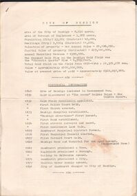
... After a brief description of the area, population, dwellings, city revenues, amount of gold and value of gold mined there is a timeline of the history of Bendigo starting in 1840 when the site of Bendigo was included in the Ravenswood run to 1891 when the city of Sandhurst changed to City of Bendigo. ...After a brief description of the area, population, dwellings, city revenues, amount of gold and value of gold mined there is a timeline of the history of Bendigo starting in 1840 when the site of Bendigo was included in the Ravenswood run to 1891 when the city of Sandhurst changed to City of Bendigo. ...9 pages document City of Bendigo historical information. After a brief description of the area, population, dwellings, city revenues, amount of gold and value of gold mined there is a timeline of the history of Bendigo starting in 1840 when the site of Bendigo was included in the Ravenswood run to 1891 when the city of Sandhurst changed to City of Bendigo. The following 8 pages dig deeper in the history starting with the find of the first gold nugget and describing the various industries that developed in the city. A description of the climate, agricultural activities, prominent people and buildings is also given.bendigo, history, city history -
 The Beechworth Burke Museum
Postcard
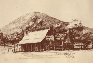
... This hut was later replaced with a dwelling using compensation money provided to Ann from the government for the loss of her property and goods; however, she was denied a new trading licence which did not enable her to re-establish her previously successful business. The reverse of this postcard provides a snippet of information into the Glenrowan siege, for which this site...This hut was later replaced with a dwelling using compensation money provided to Ann from the government for the loss of her property and goods; however, she was denied a new trading licence which did not enable her to re-establish her previously successful business. The reverse of this postcard provides a snippet of information into the Glenrowan siege, for which this site ...This Australian yesteryear postcard was published by Cobb & Co in circa 1990. It is a sepia toned artwork of the Ann Jones Inn in Glenrowan which was taken prior to 1880. The building at rear in this photograph was the private residence of Ann Jones, a migrant from Tipperary, Ireland. Two years after building her private residence, in 1878/1879, Ann Jones added the Inn to the front of the building which is depicted in the postcard. In 1880 the Inn was burned to the ground during the Kelly Gang siege. After the siege, Ann Jones and her children continued to live on the same location in a makeshift hut. This hut was later replaced with a dwelling using compensation money provided to Ann from the government for the loss of her property and goods; however, she was denied a new trading licence which did not enable her to re-establish her previously successful business. The reverse of this postcard provides a snippet of information into the Glenrowan siege, for which this site is most well-known. It outlines the role and demise of the members of the Kelly Gang but what it does not include is how Ann Jones, owner of the Inn depicted on the postcard, was impacted. Ann’s son of 13 years, Johnny was killed during the siege, and a bullet grazed the forehead of her daughter, Jane Jones. Jane would die two years after this event from tuberculosis, but it was believed by Ann that the cause was grief for the death of her brother and distress at having witnessed the siege. Ann was provided with 100 pounds in compensation money for the loss of her children. Her husband, Owen Jones passed away late 1880 and in 1891 Ann Jones remarried. She died at the age of 80 in 1910. The “last stand” of the Kelly Gang at this location is estimated by Dr Stuart Dawson of Monash University to have taken less than 10 minutes in duration. During and following this time, the life of Ann Jones was turned upside down and everything she had worked for in the preceding years was now in ruins. This postcard has the capacity to reveal information about the popularity of the Kelly story in Australia. It was created in approximately the 1990s which perhaps reveals a resurgence in interest into the Kelly Gang and Australian history when card was made. This image, and others depicting the Ann Jone’s Inn, have the ability to shed light on the Kelly story and the events of the Glenrowan Siege. Additionally, they can reveal information into the life of a female business owner during the 1870-1880 period. Archaeological research has been conducted at this site by LaTrobe University and a study of these images alongside the analysis of the material culture found at this location can help to build more comprehensive understanding into life in Australia during this period and Ann Jones herself.Sepia rectangular postcard printed on cardObverse: [Illegible] Reverse: G4/ 3276/ Australian / Yesteryear / cards/ correspondence / address / Published by Cobb & Co (03) 5766 2409 / The Glenrowan Inn owned by Ann Jones. / It was this Inn in which the Kelly Gang imprisoned / 62 people, while waiting for the special train / carrying the police to arrive from Benalla. On 28th / June 1880, following a seige which lasted over 12 / hours, Ned Kelly was captured. Joe Byrne was shot, / and the Inn was set on fire in an attempt to flush out / the two remaining outlaws, Dan Kelly and Steve / Hart. However, some time prior, the two boys, it / was believed, had committed suicide, as a result, / their bodies were incinerated beyond recognition. / A sepia tone facsimile of / an early Australian photograph. /kelly album, postcard, glenrowan inn, kelly siege, australia yesteryear card, cobb & co publisher, ned kelly capture, jones ann, dan kelly, joe byrne, steve hart, fire, train, police, benalla, 28 june 1880 -
 Camperdown & District Historical Society
Photograph - Etching of early Camperdown scene, Mt Leura Camperdown, c1850s
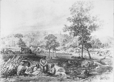
... First dwelling constructed by David Fenton in 1853 on site of Commercial Hotel. ...First dwelling constructed by David Fenton in 1853 on site of Commercial Hotel. ...This etching was created of Camperdown c1850s showing a group of First Nations people and early dwellings and native vegetation around Mounts Leura and Sugarloaf. Camperdown was surveyed by Robert Dunbar Scott in 1851. First dwelling constructed by David Fenton in 1853 on site of Commercial Hotel. Etching of early Camperdown scene showing group of First Nations people in the foreground with early buildings, native vegetation and Mount Leura and Mount Sugarloaf in the background. On front: Mt Leura, Camperdowncdhs, djargurd wurrung, djargurdwurrung, mount leura, mt leura, mount sugarloaf, mt sugarloaf, cdhsfirstnations -
 Greensborough Historical Society
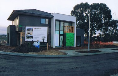
Photograph - Digital image, Frank Solomon, First dwelling in the One Evelyn Way development, 2010c
... Greensborough Historical Society 34A Glenauburn Road Lower Plenty Lower Plenty melbourne First home built on the One Evelyn Way development in Greensborough This site was previously a pig farm and there were some environmental concerns as this site was developed. one evelyn way greensborough Digital copy of colour photograph First dwelling in the One Evelyn Way development Photograph - Digital image Frank Solomon ...First home built on the One Evelyn Way development in Greensborough This site was previously a pig farm and there were some environmental concerns as this site was developed.Digital copy of colour photographone evelyn way greensborough -
 Greensborough Historical Society
Photograph - Digital Image, Chris Foster, Medhurst's shop and dwelling (Main Street Plaques Project), 17/05/2018
... dwelling on Grimshaw Street Greensborough. The Main Street Plaques Project placed historical information about original Greensborough buildings as close to the original site as possible. ...In 2018, Greensborough Historical Society placed plaques in the Main Street area of Greensborough. In these photographs, GHS President Noel Withers and GHS member Chris Foster view the plaque of Medhurst's shop and dwelling on Grimshaw Street Greensborough.The Main Street Plaques Project placed historical information about original Greensborough buildings as close to the original site as possible. Further information available on the GHS website. The Plaques were made possible through a Greensborough RSL Grant.Digital copy of 2 colour photographs.main street plaques project, medhurst family, medhurst's fruit shop, grimshaw street greensborough -
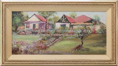 Eltham District Historical Society Inc
Painting, The David Harbison Rest Home, 10 & 12 Arthur Street, Eltham
... Site of present-day Eltham Mall The property was owned by a Mr David Harbison who was connected to one of the Melbourne daily newspapers who donated the property to the City Newsboys Society to be used as they required. The property consisted of two building blocks with one four roomed house known as the Cottage. The Secretary of the City Newsboys Society decided to use the property as a Rest Home for mothers of newsboys who needed a rest and could not afford a holiday. Miss Onians added another four roomed dwelling...Site of present-day Eltham Mall The property was owned by a Mr David Harbison who was connected to one of the Melbourne daily newspapers who donated the property to the City Newsboys Society to be used as they required. The property consisted of two building blocks with one four roomed house known as the Cottage. The Secretary of the City Newsboys Society decided to use the property as a Rest Home for mothers of newsboys who needed a rest and could not afford a holiday. Miss Onians added another four roomed dwelling ...Notes by Jock Read who donated painting to the Society: “Site of present-day Eltham Mall The property was owned by a Mr David Harbison who was connected to one of the Melbourne daily newspapers who donated the property to the City Newsboys Society to be used as they required. The property consisted of two building blocks with one four roomed house known as the Cottage. The Secretary of the City Newsboys Society decided to use the property as a Rest Home for mothers of newsboys who needed a rest and could not afford a holiday. Miss Onians added another four roomed dwelling to the home which was known as the Bungalow. Another three roomed residence was erected at the rear of the cottage for the use of the Caretaker. The rear of the property was used as a camp area for the use of Troop of Boy Scouts known as the 13th Melbourne Troop which met at the Newsboys Society Hall in Little Collins Street. Later the name of the troop was changed to City Newsboys Troop who held their Christmas camps at Eltham and Hurstbridge alternating years. In 1930 the caretaker (Mr. Francis) became ill and resigned that position. I had been a member of the scout troop and offered the position as Honorary Caretaker which I held for eight years. The Homes were used regularly as such until the death of Miss Onians. It was sold later and used as private homes until the Eltham Mall was built.” Further research has determined that apparently, Harbison left £1,000 in his will for the City Newsboys Society and the Secretary, Miss Edith Onians built the rest home from these funds. It was opened on November 12, 1919. David Harbison Rest Home, Jock Read, City Newsboys Society, 13th Melbourne Troop, Boy Scouts, City Newsboys Troop, Miss Onions, Mr Francis, Arthur Street, Eltham, Eltham Mall, David HarbisonN.D. 16 x 36 cm Oil on Masonite board UnsignedInscribed on back "The David Harbison Rest Home 10 & 12 Arthur St. Eltham" -
 Eltham District Historical Society Inc
Audio - Audio Recording, Audio Recording; 2018-06-13 Jim Connor and the history of the former Shire of Eltham office site, 13 Jun 2018
... dwellings and a fine example of the work of the well-known pioneer builder George Stebbing. In 1964 the then Shire of Eltham purchased the Shillinglaw property with the intention of demolishing the cottage and constructing new Shire offices on the site. ...dwellings and a fine example of the work of the well-known pioneer builder George Stebbing. In 1964 the then Shire of Eltham purchased the Shillinglaw property with the intention of demolishing the cottage and constructing new Shire offices on the site. ...June Meeting (Newsletter No. 240, Jun. 2018) Prior to Shillinglaw Cottage (c1878-80) being relocated to where it is now operated as a popular cafe near the Eltham Library, it was within Josiah Holloway’s 1850s subdivision known as Little Eltham, which later became the centre of the first Eltham township. Originally a farmer’s cottage it is historically significant because it is one of the Shire’s oldest dwellings and a fine example of the work of the well-known pioneer builder George Stebbing. In 1964 the then Shire of Eltham purchased the Shillinglaw property with the intention of demolishing the cottage and constructing new Shire offices on the site. However extensive community action resulted in funds being raised to have the building saved and relocated further south to the Eltham Common, where it was joined by the Eltham Library 1994. New Shire offices opened in 1965, but following municipal restructure in 1994 these were demolished and the land sold to a developer, which precipitated a dramatic trail of community angst, threats of legal action, the sacking of a newly elected council and several unsuccessful development proposals, by subsequent councils. After all these years the vacant site there is still guarded by the three trees that were outside the front of the Shillinglaw Cottage. At our Society meeting on Wednesday 13th June 2018 Jim Connor will speak about the dramatic tale encompassing the history of the former Eltham Shire office site and the adjoining War Memorial Buildings complex, which are now being considered for sale or redevelopment by the current Nillumbik Shire Council.1:17:57 duration Digital MP3 File 27 MB audio recording, eltham district historical society, jim connor, meeting, shire of eltham office site, society meeting -
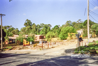 Eltham District Historical Society Inc
Photograph, Clearing land for Le Pine Funeral Home, cnr York Street and Main Road, Eltham, c.March 1998, 1998
... The site contains an architect's office in a building which was formerly a shop and dwelling dating from the 1920's. ...The site contains an architect's office in a building which was formerly a shop and dwelling dating from the 1920's. ...Newsletter No. 116, September, 1997 846-848 MAIN ROAD ELTHAM Nillumbik Shire Council has granted a permit for a funeral parlour on land which includes this site at the corner of Main Road and York Street. The site contains an architect's office in a building which was formerly a shop and dwelling dating from the 1920's. The proposal requires demolition of this building which is one of the few remaining old shops which formed the rather spread out "town centre" of Eltham. Prior to making its decision the Council obtained a report from Graeme Butler and Associates, the heritage consultants who carried out Stage 1 of the Nillumbik Heritage Study. The report summarized the historical significance as follows:- "This brick comer shop with associated residence has potential local historical significance as a late 1920's grocer's shop, now much altered and one of only a few shops of that era left in Eltham's Main Road. This significance is qualified by the many changes. The other examples are better preserved and still function as shops." With this type of expert advice it is difficult to make a strong case for preservation of the building although, of course, it is a shame to see it demolished. The report includes details of the site itself and its history based on research carried out by Carlotta Kellaway. The building dates from the late 1920's when it was owned by C.R. Nicholls. From the early 1930's it was Charles Cockroft's grocery shop and he also ran a grain store there. According to his daughter, Edna Brown, he delivered groceries around the district taking his truck as far as Kangaroo Ground. In 1950 he shifted to Traralgon. Since then several different businesses have operated from the site including a bottle merchant and produce store. Conversion to the present office use involved alterations to the shop front and rebuilding the galvanized iron store at the rear. Newsletter 119 March 1998 In our Newsletter No. 116 it was reported that the former shop on the comer of Main Road and York Street, Eltham was to be demolished as part of a funeral parlour development. If you have passed the site recently you will have noticed that it has now been demolished - another part of the old Eltham township has disappeared.Roll of 35mm colour negative film, 6 strips Also photographic prints 10 x 15 cmKodak Gold 200-6a.r. warren, eltham feed store, le pine funeral home, main road, york street, c.r. nicholls, charles cockcroft, grocery store -
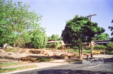
 Eltham District Historical Society Inc
Slide, Joh Ebeli, The old Baker's house prior to demolition, corner of York Street and Main Road, Eltham, c.Sep. 1979
... dwelling with a shop in the front room opening off a timber verandah deck which directly fronted the Main Road footpath. At the rear is a brick building of much later date which was for many years used for the bakery. The buildings were demolished for flat construction. Publicity at the time was oriented toward moves to preserve the weatherboard building which came from a number of individuals including members of this society. The society had no official connection with any proposal to retain the building or any part of it on any other site...dwelling with a shop in the front room opening off a timber verandah deck which directly fronted the Main Road footpath. At the rear is a brick building of much later date which was for many years used for the bakery. The buildings were demolished for flat construction. Publicity at the time was oriented toward moves to preserve the weatherboard building which came from a number of individuals including members of this society. The society had no official connection with any proposal to retain the building or any part of it on any other site ...Photo taken immediately prior to the demolition of the old baker's shop on the corner of Main Road and York Street, Eltham. Joh Ebeli and Elwers Howard endeavoured to preserve some parts of the house. The old weatherboard building, possibly dating from the 1860s, comprised a dwelling with a shop in the front room opening off a timber verandah deck which directly fronted the Main Road footpath. At the rear is a brick building of much later date which was for many years used for the bakery. The buildings were demolished for flat construction. Publicity at the time was oriented toward moves to preserve the weatherboard building which came from a number of individuals including members of this society. The society had no official connection with any proposal to retain the building or any part of it on any other site. The issues involved were part of a wider consideration of the matter of preservation of historic buildings. In this case the Society and in particular the committee had been aware for some years of the impending demolition. The possibility of the preservation of the building had been canvassed on a number of occasions. The Society’s view was that whilst the baker’s shop was an interesting old building which contributed to the character of Main Road, it was not of sufficient importance to wage an organised campaign for its preservation. It considered that if the building were to be preserved for historical reasons it would be far more feasible to retain it in its present location than to re-build it on another site.35 mm colour positive transparency Mount - Agfachrome Professional black (Germany) 4 dotsmain road, old eltham bakery, york street -
 Eltham District Historical Society Inc
Slide - Photograph, Second Life, 736 Main Road, Eltham, c.May 1988
... The c1920 brick shop and side dwelling is one of just three early 20th century shop buildings left in Eltham and one of just two that have intact facades. These shops are physical links with the country village of Eltham at that time and their siting in isolated locations along the street reflects that village era. ...Eltham District Historical Society Inc 728 Main Rd Eltham melbourne The c1920 brick shop and side dwelling is one of just three early 20th century shop buildings left in Eltham and one of just two that have intact facades. These shops are physical links with the country village of Eltham at that time and their siting in isolated locations along the street reflects that village era. ...The c1920 brick shop and side dwelling is one of just three early 20th century shop buildings left in Eltham and one of just two that have intact facades. These shops are physical links with the country village of Eltham at that time and their siting in isolated locations along the street reflects that village era. Since the 1950s Eltham's main street has changed dramatically and the intact pre 1940 buildings such as this shop are key components of the section of Main Road south of Henry Street which still has a streetscape recognisable from that earlier time. The side dwelling illustrates the common practice of that time for shopkeepers to live at their premises. In the 1990s this was an antique Shop and in 2010 “Eltham Cycles”. It is now a popular eatery – Zen Den. 35mm colour positive transparency (1 of 23) Mount - Kodak EktachromeProcess Date MAY 88Meltham, main road, antiques and old wares, cafe zen den, restaurants, second hand dealer, second life decor pty ltd, shops